Ausgrabung eines christlichen Klosters der Kirche des Ostens
| 2004 | 2005 | 2006 | 2007 | 2008 | Publications |
Ausgangslage
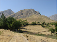
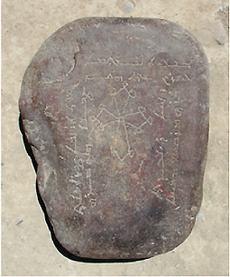
Der Ort Urgut befindet sich rund 30 km südlich Samarkands im einstigen Sogdien. Heute gehört Urgut zu Usbekistan. In der Nähe Urguts sind in einer Felswand an die einhundert rund 1000 Jahre alte syrische Inschriften sowie Kreuze eingemeißelt, die mit der Kirche des Ostens, den sogenannten Nestorianern in Zusammenhang stehen könnten.3 Eine solche Inschrift ist mit dem Jahr 1206 Alexanders datiert, was dem Jahr 895 unserer Zeitrechnung entspricht.4 Die Kirche des Ostens, deren Sitz sich in Seleukia-Ktesiphon, ab 780 in Bagdad, Irak befand, zählte zu ihrer Glanzzeit im 12./13. Jahrhundert 27 Metropolitansitze, über 200 Bistümer und 10-15 Mio. Gläubige. Ihre Diözesen reichten von Ägypten und Syrien im Westen über Mesopotamien, den Iran und Zentralasien bis nach China und in die Mongolei sowie nach Indien im Osten. Das nestorianische, auch ostsyrisch genannte Christentum erreichte Sogdien im 5. Jahrhundert, das Bistum Samarkand wurde spätestens in der Mitte des 9. Jahrhunderts zum Metropolitansitz erhoben. Das Christentum erlosch in Sogdien gegen Ende des 14. Jahrhunderts.
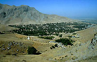 Urgut: Übersicht |
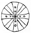
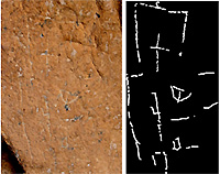
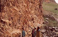 Die Felswand mit den Inschriften |
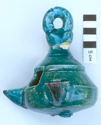
Bei Urgut wurde sodann 1916 ein kleines, bronzenes Weihrauchgefäß aus dem 8./9. Jahrhundert gefunden, das mit neutestamentlichen Szenen verziert ist und sich heute im Eremitage Museum in St. Petersburg befindet. (Nr. CA 12 758)5 Ende des 19. Jahrhunderts wurden bei Urgut auch zwei mit einem Kreuz versehene, nestorianische Grabsteine gefunden; sie befinden sich im Museum von Askhabad, Turkmenistan.6 Ebenfalls aus Urgut stammt ein tragbares Kreuz aus örtlichem Schieferstein. Weitere Kleinfunde aus diesem Teil Sogdiens vom 7. bis 9. Jh. verweisen auf eine damalige christliche Gemeinde. Zu ihnen gehören bei Taschkent, Samarkand und Penjikent entdeckte Münzen aus dem 6./8. Jh., die auf der Rückseite ein maltesisches Kreuz aufweisen; diese sind vielsagend, da einzig Stadtbehörden oder Herrscher Münzen prägen konnten. Ebenfalls aus Penjikent stammen ein mit Psalmen aus der Peshitta-Bibel in der syrischen Estrangela-Schrift beschriebener Keramikscherbe vom frühen 8. Jh. und ein bronzenes Kreuz. Aus Samarkand ein weiteres Kreuz sowie eine mit Kreuzen und einem Heiligen verzierte Reiseflasche. 7
 Altsyrische Inschrift |
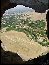
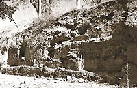 Grabungsort |
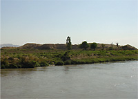
Eine literarische Quelle vermittelt eine weitere Auskunft: Der muslimische Geograph und Historiker Abu-´l-Qasim Muhammed Ibn Hawqal aus dem 10. Jahrhundert beschreibt in seinem Reisebericht Darstellung der Erde ein bei Samarkand gelegenes christliches Kloster, das er um 970 besuchte. Al-Sawadar ist ein Berg südlich Samarkands. Beim Berg Sawadar sieht man ein Kloster, wo Christen zusammenkommen und wo sie ihre Zellen haben. Ich traf dort viele Christen aus dem Irak, die sich wegen der guten und einsamen Lage und des gesunden Klimas hierher zurückziehen. Der Ort thront über Sogdien, er heißt Wazkard. 8
Der russische Archäologe Alexei Savchenko glaubt, daß Wzkrd, das in einer anderen Handschrift Wrkwd genannt wird, mit Urgut identisch ist. Seine 1997 bis 1999 durchgeführten Ausgrabungen brachten einen architektonischen Komplex mit einigen Räumen zutage, die möglicherweise zu einem Kloster gehören könnten. Die Radiokarbon-Messungen von Baumaterialien deuten auf eine Gründung im 9. Jahrhundert.9 Leider haben schon 1995 Straßenbauarbeiten die westlichen und östlichen Ränder der Anlage zerstört. Finanzielle Engpässe verunmöglichten nach 1999 die Fortführung der vielversprechenden Ausgrabung.
Bedeutung
Infolge der Zerstörung praktisch aller architektonischen Zeugnisse der Kirche des Ostens östlich Irans durch Kriege und gezielte Verfolgungen wäre der Fund eines nestorianischen Klosters von großer kultur- und religionsgeschichtlicher Relevanz. Wenn man von den relativ zahlreichen christlichen Grabsteinen Kyrgyzstans, Usbekistans, Chinas und der Inneren Mongolei, ein paar chinesischen Stelen sowie der spärlichen baulichen Relikte Keralas in Südwestindien absieht, sind die einzigen architektonischen Zeugnisse der Kirche des Ostens die Fundamente eines größeren Kirchenkomplexes, einer weiteren Kirche und einer kleinen Kapelle in Ak-Beshim, Kyrgyzstan, einer mutmaßlichen Kirche in Termez, Usbekistan,10 einer Kirche in Qocho, Xinjiang, eines mutmaßlichen Klosters Ta Qin bei Wuchun, Shaanxi sowie einer kaum mehr erkennbaren Kirche in Olon Sume, Innere Mongolei die drei letzteren in China liegend. Falls sich die Ruinen Urguts als diejenigen eines nestorianischen (oder jakobitischen) Klosters entpuppten, wäre diese Erkenntnis von größter Bedeutsamkeit.
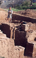 Ausgrabungsarbeiten |
 Ausgrabungsarbeiten |
Zielsetzung
Die geplante Ausgrabungskampagne wird versuchen, die mutmaßliche Klosterkirche zu finden um den monastischen Charakter der Anlage abzusichern. Auch ist unweit davon eine mögliche Gräberzone zu erforschen.
| Projektleitung Dr. Alexei Savchenko Islamwissenschaftler und Archäologe Bekhterevsky per. 13, kv.9 04053 Kiev, Ukraine www.apple.kiev.ua/esarex |
Zum Namen und Ort des christilichen Klosters von Urgut siehe folgenden Beitrag von Dr. Alexei Savchenko ( |
mit der Mitarbeit des:
Archäologischen Instituts Samarkand
_______________________________
3 Einzig aufgrund der Inschriften läßt sich nicht entscheiden, ob sie von ostsyrischen Nestorianern oder von westsyrischen Jakobiten stammen. Ähnliches betrifft die auszugrabenden Ruinen, die zu einem nestorianischen oder einem jakobitischen Kloster gehören könnten. Die viel stärkere Ausbreitung der Nestorianer in Sogdien als diejenige der Jakobiten läßt allerdings ein ostsyrisches Kloster als die wahrscheinlichere Hypothese erscheinen.
4 Tardieu Michel: Un site chrétien dans la Sogdiane des Sâmânides. In: Le Monde de la Bible,
No. 119. Mai-Juni 1999. S. 42.
5 Savchenko Alexei: Urgut Revisited. In: ARAM, Journal of the Society for Syro-Mesopotamian Studies, vol. 8: 1&2. Oxford-Harvard 1996. S. 334f. The Monastery of Urgut investigated by The East Sogdian Archaeological Expedition. ESAREX, 1999. S. 1. www.apple.kiev.ua/esarex
6 Klein Wassilios: Das nestorianische Christentum an den Handelswegen durch Kyrgyzstan bis zum 14. Jh. S. 226f. Brepols, Turnhout 2000.
7 Paykova Aza Vladimirovna: The Syrian Ostracon from Panjikant. In: Le Muséon, Éditions Peeters, Leuven 92/1-2, 1979. S. 159-169. Savchenko Alexei: Urgut Revisited. In: ARAM, S. 339.
8 Ibn Hawqal: La Configuration de la Terre. Ca. 988. Introduction et traduction par J.H. Kramerd, G. Wiet. Maisonneuve & Larose, 2 Bde. Paris 2001. S. 477f.
9 Savchenko Alexei: The Monastery of Urgut investigated. S. 5.
10 Albaum, L.I.: Xristianskij xram v starom Termeze. In: Iz istorii drevnix kultovsrednej Azii. Xristianstvo. Glavnaja Redakciha Enciklopedii, Taskent 1994. S. 34-41.
Kurzbericht der Grabungskampagne 2004
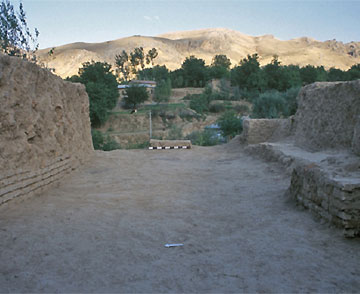
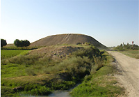
Die archäologische Expedition von Ost-Sogdien nahm dieses Jahr ihre Ausgrabungen am Ort Sulayman-tepe wieder auf, das bei älteren Einheimischen auch als Urus-Machit, die russische Moschee, bekannt ist. Sie dauerten sechs Wochen vom 16. August bis zum 25. September. Obwohl in der Vergangenheit vorgenommene Landwirtschaftsarbeiten das Zielgebiet teilweise beschädigt haben, sind die Gebäude und Strukturen immer noch genügend gut erhalten.
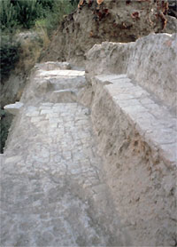
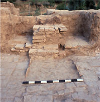
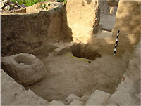
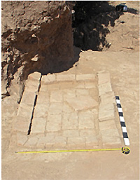
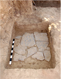
Die Ausgrabungen von 2004 konzentrierten sich im Zentrum der Stelle, wo 1999 durchgeführte Probegrabungen gut erhaltene Mauern und gepflasterten Boden nachgewiesen hatten. Es sollten nun die Funktion der Räume identifiziert, datierbare Funde geborgen und der Ort kartographiert werden. Gleichzeitig wurde die Ausgrabung zweier Brunnen östlich der Hauptausgrabungsstelle beschlossen. Die Ausgrabungen legten einen recht großen Teil eines architektonischen Komplexes frei, der durchaus klösterlicher Natur gewesen sein könnte. Auf Grund gefundener Keramik läßt er sich um das 9. bis 13. Jh. u.Z. datieren. Die architektonischen Funde zeigen nach einem klaren Plan angelegte Räume und Korridore. Alle Räume wurden bis auf den gepflasterten Boden oder den Erdboden freigelegt, ohne daß ihre Funktion bestimmt werden konnte. Die Mauern, die bis zu 3 m hoch sein mochten, waren vielerorts zerstört. Sie scheinen nicht auf ein Mal eingestürzt zu sein, sondern stückweise, vielleicht über einen längeren Zeitraum verteilt.
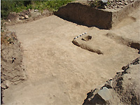
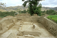 Die 2004 ausgegrabene Stätte; im Hintergrund die Felsen mit den Inschriften. |
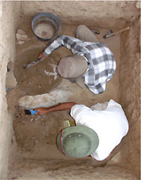
 Das Grabungsteam |
Es wurden mehrere Nutzungsperioden identifiziert: Die früheste stand in Zusammenhang mit dem ursprünglichen Gebäudezweck, die späteren sind vermutlich Wiederbesetzungen nachdem die ursprünglichen Strukturen Schaden erlitten hatten und aufgegeben oder zerstört waren. Diese Phase einer Hausbesetzung wird durch eine kleine, temporäre Feuerstelle innerhalb des gepflasterten Bodens dokumentiert. Als Baumaterial dienten vor Ort gebrannte Ziegel unterschiedlicher Größe (30 x 15 x 5 cm, 23 x 23 x 5 cm, 30 x 30 x 5 cm und 27 x 8 x 5 cm), Keramikkacheln von 30 x 20 x 2.5 cm für den Boden sowie Lehmziegel. Unter dem Schutt, der von einer Wand gefallen war, fanden sich Fragmente von dekorativem Verputz und Spuren smaragdgrünen, karminroten, ocker, weißen und kobaltfarbenen Stucks.
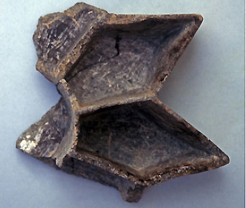
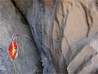
Ein lang ersehnter Fund war die Entdeckung eines überzeugenden Beweisstückes für eine christliche Anwesenheit an dieser Stätte. Es ist ein metallenes, vielleicht tragbares Kreuz, das im gleichen Kontext wie eine gut erhaltene Öllampe aus dem 13. Jh. gefunden wurde. Dieser Fund bestätigt unsere Hypothese einer christlichen Anwesenheit in Urgut; er ergänzt und bereichert die in historischen Texten vorhandene Information.
|
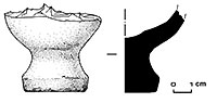
_klein.jpg) Metallkreuz |
Fortführung der Erforschung
Das gefundene Material inklusive der Münzen wird vertieft analysiert. Die archäologischen Arbeiten werden im Mai-Juni 2005 wieder aufgenommen. Inzwischen wird die archäologische Stätte bewacht um Störungen zu vermeiden.
Der Grabungsbericht für 2005 ist zurzeit nur in der englischen Fassung verfügbar.
Excavations in Urgut: August–October 2005
Progress Report
 |
|
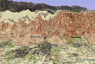
GIS by Dr E. Potapov, Univ. of Pennsylvania, eye alt. 8.51 km |
This year the research team continued excavations of the site of Sulayman-tepa, believed to have been the seat of the Christian monastery of Warkūda (present-day Urgut) in IX–XIII AD.1 The site with precise geographical coordinates: 39º22'46'' N, 67º14'28'' E, elevation 1134 m is situated at the southernmost edge of the habitable territory of the town of Urgut, Samarkand province, Republic of Uzbekistan.
The goal set for this season was to extend the excavations in the three available directions (north, east
and south) in order to uncover the perimeter walls and to excavate the previously pin-pointed room behind
the main northern wall.
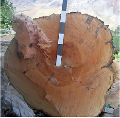 |
Works in the S–E sector were obstructed by the huge planetree overhanging the dig and having its roots deep in the earth mass. The tree had to be removed as it was a danger to the people working around and could destroy some fine architectural elements had it suddenly fallen. Upon cutting down the tree, a dendrochronological examination of its trunk was done. The tree appeared to be 700-800 years old, which means that it grew here (or was intentionally planted) no great length of time after the decline of the settlement in XIII AD. This additional chronological evidence accords well with the terminus post quem so far established for the site on the basis of the ceramics, coins and radiocarbon analysis. |
1The background to the excavations is described in my papers: “Urgut Revisited”, ARAM Periodical (The Journal of the Society for Syro-Mesopotamian Studies, Oxford–Harvard) № 8 (1996); “По следам арабских географов” (In the Footsteps of Arabic Geographers), Археологические исследования в Украине (Archaeological Researches in Ukraine) № 7 (2003–2004), Kiev 2005; “По поводу христианского селения Ургут” (On the Christian Settlement of Urgut), Записки Восточного отделения Российского географического общества (Transactions of the Oriental Department of the Russian Archaeological Society) № 2 (XXVII), St. Petersburg 2006.
 |
A group of plane-trees of
the same age or older
mark the mazar (holy
grave) of Khoja Abu Talib
Sarmast, one of the four
missionaries who came to
Urgut from Bukhara to
propagate Islam in X AD.
This mazar, known locally
as Chor-Chinor ("Four
Plane-Trees"), is situated
near Sulayman-tepa, and
a possible link might be
established by further research. |
The tree shown here was 1050 years old at the time of the dating (1990s), as attested by the plate in the top left corner of the photo. Before 1920 there was a Muslim grammar school (maktab) inside the trunk.
After the loess sediments were removed, we were pleased to observe that the main eastern wall survived the destruction of 1996, being intact. This fact allows to analyse the space syntax of the complex in its entirety, greatly increasing the value of the results and the plausibility of the reconstruction. The main eastern wall was made of mud brick, a narrow stripe of outside premises paved with fired brick situated behind it. At least two building horizons are present. Some boulder stones that still remain in the vertical plane of the hill at various heights, as well as memories of the old inhabitants2 suggest that initially this slope had been converted into a sequence of terraces gradually lowering towards the east.
 |
 |
| Space behind the main eastern wall, looking north | Same space, looking south |
2 Of the informants I should pick out as the most knowledgeable and co-operative Warr. Off. Ret. Khursan-
Murad Ghaffarov, the present Guardian of Sulayman-tepa, and Timurlang Khalikov, 80-year-old healer, storyteller and keeper of the local lore.
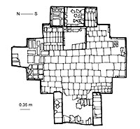
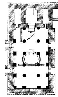
In order to interpret the form and function of the excavated part of the building we shall now treat it
together with the previously excavated sectors. There is an element of standardization which suggests
a system at work that fits well with the order implicit in a monastic settlement, where uniformity of
building would be a characteristic of the community.
The overall layout of the complex can be conveniently described as two aisles separated by a raised
platform in the centre. The walls of the platform were made of fired brick, forming a rectangular structure
up to 25 rows of brick high in the better preserved wertern part. This perimeter was filled with
clayey loess well rammed to the surface of the ground (a vertical stratigraphic shaft has been laid to
check the uniformity of the filling). The fact that the purpose of the walls was to serve as a contour
only is confirmed by the fact that no care has been taken to arrange bricks regularly inside, by contrast
to the smooth line of brickwork on the outside.3
The top of the platform could be reached through the aperture in its western wall which must have
been followed by a mud brick or loess stairway, not preserved.
I believe that the most plausible interpretation of this platform is as of a bēma which played an important
role in the liturgical setting of the Eastern Syrian churches and was situated in the centre of the
nave (although the exact position varies). If this assumption is correct, then we have a quite rare example
of an Eastern Syrian church with a well-preserved bema, since little archaeological material independently
confirms its importance.4
3 “Inside” and “outside” relate here to the walls of the platform, which still is part of the interior of the building.
This means that the outside of the platform was seen by the visitors as the walls of the northern and southern
aisles and of the western corridor between them.
4 Of the recent studies v. Marica Cassis, ‘The Bema in the East Syriac Church In Light of New Archaeological
Evidence’, Hugoye: Journal of Syriac Studies, Vol. 5, № 2 (July 2002), and the bibliography therein.
Northern aisle and chancel
 |
 |
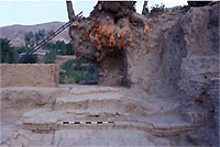
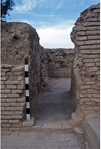
The northern aisle starts with the main entrance in the western wall excavated in 1999 and continues
eastwards, elevating by three steps before reaching the culmination point. The fine investigation
revealed there a cross-shaped room recognisable as chancel, with the altar adjoining the eastern wall
and constructed of fired brick. The seat of the priest who, in the tradition the Church of the East, was
serving the liturgy facing the altar, is marked by ceramic tiles inserted into the flooring edgewise.
The floor of this room is made of ceramic tiles plastered with a fine gypsum which is still intact
over most of the church interior. Small fragments of stucco were found on the walls, adding colour
carmine to the range already established: white, emerald-green, ochre and ultramarine. These traces of
colouring are so slight that it is impossible to determine whether they are the remains of a single
overall colouring or some more complex decoration.
Southern aisle and beyond
 |
Another aisle, also extended along the axe W–E, is situated between the southern side of the platform and the main southern wall. The wall ca. 1,5 m thick was made of mud brick faced with several rows of fired brick on the inside. It has two doorways leading outside, one of which was intentionally filled with rubble and brick breakage. |
In the east the wall ends with a curving suggesting an apse; however,
its clear delineation or just any fine investigation of this corner was complicated by the ubiquitous
roots of the plane-tree which have greatly deformed all surrounding substance.
The floor of the aisle is paved with fine quality ceramic tiles with traces of plaster finish in several
places. In the east the floor elevates to form several footsteps leading outside the main eastern wall. At
least one footstep was made using the common dandona technique, when the bricks are laid edgewise
in order to increase wear resistance. It is on these footsteps that the iron cross was found during the
last year’s field campaign.
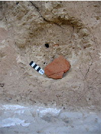 |
Outside the main eastern wall were the remains of another
premise, also under the roof judging from the gypsum plastering
of the paved floor. In the centre of this room, exactly on the
axis W–E stands a rectangular base made of fired brick. The
location of this room and a decorative context in the form of a
rounded niche filled with a ceramic plaque suggest its use as an
oratorium external to the main nave.
In the cross piece of the eastern wall between the central
and the south-eastern sectors, in a niche, was found a glazed
lantern full of substances which are likely to be oil. This is an excellent and rare case of obtaining sufficient amount of material for C14 sampling. The contents was passed to the Radiocarbon Dating Lab of St. Petersburg Institute of Archaeology where it will be examined by Dr Sergei Vartanian. |
| Decorated niche in the rear side of the main eastern wall. |
Northern yard
 |
 |
This space with an earthen floor, external to the main building, is linked to the northern aisle by two
doorways in the main northern wall and one more narrow passage connecting it to the chancel. In the
eastern end there is another rectangular stand made of fired brick. The room was not excavated at full
length due to the lack of time; this is the direction in which the excavations will continue in the next season.
Finds
 |
 |
| Glasswork found in the bottom of the water reservoir connected by an underground tunnel to the mountain water stream. | Fragment of a stone lantern from the chancel. |
As there is a good reference collection of stratified ceramics for the area, there are no difficulties for
the interpretation of our finds. The study of the pottery and glasswork from the excavated site suggests
an early Samanide date for the founding and an early Mongol date for the end of the main occupational
period (followed by the another with a squatter re-occupation after damage to the original
structures).
While these preliminary observations may require amendment in the light of future excavation,
there is enough evidence available at present to propose that the Sulayman-tepa assemblage indicates
occupation between IX AD and XIII AD, and not extending far into the Mongol period. This accords
well with the previously obtained C14 dates (one more process is pending).
The first evidence of a Christian element at the
site came to light in 2004 when an iron cross was
found on the steps in the eastern part of the
southern aisle. More Christian artefacts, found in
this season, should be included into this report:
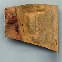 |
 |
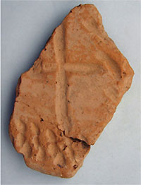
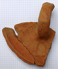
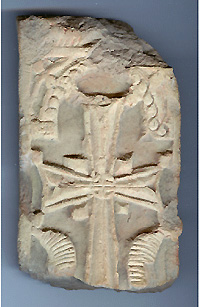
| Fragment of a decorative tile from the nave. | Fragment of a plate with an offprint of
a seal with a "Nestorian" cross. |
 |
|
| Fragment of a ceramic plate kept in a niche. |
Parallels
While the full rationalisation will only be possible when all adjacent rooms are excavated, the most
exact parallel to the site is provided by the church complex recently excavated in Aq-Beshim, Qirghizstan,
and brought to scholarly notice by G. Semionov, Суяб. Ак-Бешим (Suyab. Ak-Beshim), St.
Petersburg 2002, pp. 44-114.
Addenda
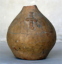
A moulded ceramic pot featuring a cross and an ornamental scribble resembling Syriac characters
suddenly came to light this year, some 40 years after it had been unearthed in Urgut. It was kept at a
private collection in Samarkand, where Mr Firdaws Naberayev of the Regional Inspectorate of the
Antiquities noticed it and brought it to my attention.
By an almost holmesiane inquiry I managed to establish that it was found in the late 60-ies by the
now retired schoolteacher Juma Daniyorov, who with the help of his pupils once undertook amateur
excavations of a tepa in his home village of Gus-Say, the western suburb of Urgut.
Great is my indebtness and gratitude to the owners, Ms Kutbiya Rafiyeva and Ms Aziza Haydarova,
who kindly agreed to give it as a free gift to the Samarkand Historical Museum when they realised
its importance.5
 |
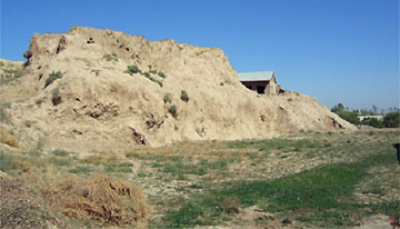 |
| Pot for hallowed water of oil, VII-XI AD. | Quq-tepa in Gus-Say where it was found. |
In this season a vague semantic link has been tentatively established between the monastery and the
inscriptions on the rock above it. While doing theodolite survey, we observed that the walls of the
building, despite being very neatly erected, deviate from the magnetic axis by 15º. This is explained by
the simple fact that, in the absence of a compass, the builders’ only reference points were those of
sunrise and sunset. The rocks of the two mountain ranges – Qutirbuloq to the east and Gulbogh to the
west – prevent the viewer from seeing the sun at horizon level (which would have more or less coincided
with the geographical East of West). This fact means that the reference point shifts a number of
degrees, as it takes the sun some time to move from the horizon to the point where it becomes visible
above the hills.
It can now be stated with confidence that in the summer period (that is, when the building works
should have been conducted), the sun rises at dawn exactly from behind the rock of Qizil-Qiya (“The
Red Rock”), as opposed to any of the other rock in the Qutirbuloq gorge that are clearly visible from
the site. Since I am unable to comment on this fact any further at this stage, I will leave it as is.
It would be appropriate to add here that two more inscriptions from this epigraphic site have been read
and interpreted recently by Prof. N. Sims-Williams of SOAS, London, throwing light upon the monastery’s
geographical connections. One of them (also showing a cross) consists in the word bxt “[good] fortune” in the Sogdian adaptation of the Syriac script (while the form is Persian); the other
may be Turkish Alp (“hero”, personal name) in Uighur script.
5 The two refined ladies run a small private hotel in the historical centre of Samarkand which I would recommend
to any short- or long-term visitor. 58 Iskandarov St. (just off the Gur-Emir Mausoleum), tel. 2352092,
muhandis2004@rambler.ru May an increased flow of visitors be a reward for their co-operation.
|
 |
Acknowledgements
This year, Dr Gennadiy Ivanov volunteered to take charge of the cameral work and to assist with the
excavations. I have long known this archaeologist, formerly based in the Ferghana valley, as one of
the country’s leading specialists in the field; however, we had met only briefly. Having spent two
months together in the hills, I realised in full measure the scope of this scholar’s erudition, experience
and insight. I can only regret that our acquaintance did not take place in the former years; I am comforting
myself with the idea that the real investigation of the lost monastery is just starting.
Alexei Savchenko Director of Research The East Sogdian Archaeological Expedition  Alexei Savchenko, Olga Jouravleva (Architect, ESAREX) and Christoph Baumer, President, The Society for the Exploration of Eurasia. |
 |
Der Grabungsbericht für 2006 ist zurzeit nur in der englischen Fassung verfügbar.
Excavations in Urgut: June – July 2006
Progress Report
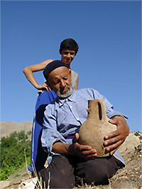
Timurlan Khalikov holding a 10 th century jar discovered at Urgut.
He helped identifying the location of the monastery.
A new field campaign at Sulayman-tepa in Urgut was conducted during May and June, 2006. This year, the excavations were concerned with the area to the north and south of the church building unearthed in the previous seasons. The aim was to complete the excavations of the northern nave, to uncover the outside edge of the main walls, and to improve the general plan. The northern nave was excavated down to the level of the beaten clay floor. The entrance from the western side appeared to had been filled with rubble, which probably indicates a squatter occupational period of the complex. Summarising the result, it can be safely argued that beyond the southern nave there lies an open yard with no architectural structures whatsoever; beyond the northern nave a habitational context was discovered consisting of a number of ovens ( tandoors ) and a cesspit ( badrab ), leaving us with the interpretation of this sector as a kitchen.
 |
It is this context which provided us with the earliest dated find so far: a bronze coin of the Sogdian ruler ( ikhshid ) Turghar, 1 st quarter VIII AD (type B according to the accepted classification)1 . |
| Space in front of the entrance to the northern nave, facing north-east. |
 |
The new chronological evidence provided by this singular find is amplified by another artefact dating to the same period or earlier: fragment of a ceramic beaker being an imitation of a wooden prototype. While a fuller substantiation will only be possible after this sector is studied in its entirety, these finds throw new light upon the chronology of the complex, shifting its possible terminus ante quem back by a century. |
The earliest firm evidence for the monastery was so far provided by the date in an inscription on the rock of Qizil-qiya, August of the year 1206 [of Alexander] = August 895 2. However, it would be natural to expect that the monastery was founded before the Arab conquests (around AD 712 for the district of Samarkand), since the Islamic restrictions on new church building are well-known.3 Still there were some exceptions from the general rule, e.g. legal church construction in Muslim Spain 4 or the foundation of the Monophysite Church of Mary Magdalene at Jerusalem, endowed by a notable of Alexandria in 820 5.
1 O. I. Smirnova, Svodniy katalog sogdiyskikh monet, Moskow: Nauka 1981, q. v.
2) M. Tardieu, ‘Un site chrétien dans la Sogdiane des Samanides’, Le monde de la Bible 119 (mai-juin 1999), p. 42.
3) See, e.g.: Abū Zakaryā Yahyā b. Sharaf al-Nawawī (AD 1233-1278), Al-minhaj bi-sharh Sahīh Muslim, English translation in Bat Ye‘or, Islam and Dhimmitude: Where Civilizations Collide, Fairleigh Dickinson University Press 2002.
4) Sally Garen, ‘Santa María de Melque and Church Construction under Muslim Rule’, The Journal of the Society of Architectural Historians, vol. 51 № 3 (September 1992), pp. 288-305.
5) Severus ibn al-Mukaffa‘, ‘History of the Patriarchs of the Coptic Church of Alexandria’, Patrologia Orientalis Vol. 10.5, col. 460.
 |
|
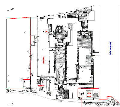
| The red line indicates the area excavated in 2006. |
The main problem presented by the ground plan is that of the prototypes. The cross-shaped chancel terminating the nave finds its parallels in the following known examples:
 |
 |
Church ? XI at Hira according to D. Talbot Rice, Arte Cristiana in Asia', in: Giuseppe Tucci (ed.), Le civiltà dell'Oriente. Storia, letteratura, religioni, filosofia, scienze e arte , vol. IV, Roma: Gherardo Casini 1962, p. 441 fig. 7. |
Monastic church of Mar Ibrahim and Mar Ubil at Midiat according to G. Bell, The Churches and Monasteries of the Tur Abdin , London: Pindar Pres 1982, p. 36 fig. 23. |
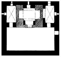 |
 |
| Monastic church at Arica (Kefri) according to G. Wießner, Christlische Kultbauten im Tur Abdin , Wiesbaden: Otto Harrasowitz 1982, p. 30 fig. 5. | Church in the Akkese village of Viransehir (Tella), plan courtesy of Elif Keser-Kayaalp, Exeter College, Oxford, unpublished. The cross-shaped room is a burial chamber. |
Of the three ecclesiastical buildings known in Central Asia6 the same feature is present at the more recently excavated church in Aq-Beshim7.
6) see the detailed discussion in: A. Naymark, Sogdiana, Its Christians and Byzantium: A Study of Artistic and Cultural Connections in Late Antiquity and Early Middle Ages , unpublished PhD thesis, Univ. of Indiana 2001.
7) G. Semenov, Suyab. Ak-Beshim , St. Petersburg 2002, figs. 2, 4, and 27.
 |
However, the closest architectural parallel seems to be presented by Church 7 in Hakkari, the easternmost province of Turkey which was the stronghold of the Nestorians until the First World War and where the Patriarch of the Assyrian Church of the East was resident. The Lives and Legends of Saints of the Hakkari date its sanctuaries to IVV AD.8 If the identification of Church 7 with Mar Awraha is correct, this was a well-known and much-frequented place of worship. |
||||
| Mar Awraha according to C. Dauphin, Rediscovery of the Nestorian Churches of the Hakkari (South Eastern Turkey), Eastern Churches Review Vol. VIII (1976), p. 63 fig. 6. | |||||
 |
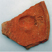
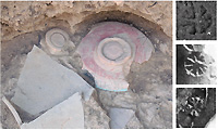
Speaking of the finds, one spectacular artefact must be mentioned. It is a fragment of a lid of ceramic vessel with an offprint of a crossshaped stamp, thumb-print and a decorative pattern of several rows of notches. Another fragment of the same item was found in 2005, with the same motif (v. the report for that year).
|
In the light of the above-listed parallels I would cautiously highlight the fact that Mt Allahyarhan , the mount of the zealots, at the foothills of which the monastery was situated, shares its semantic core with Tur Abdin , the mount of the servants [of God].
8) J.-M. Fiey, Proto-histoire chrétienne du Hakkari turc', L'Orient Syrien 9 (1969), pp. 443-72.
Faith Carved on the Rocks
In this season, a number of previously unknown Syriac inscriptions were found, sought after since our first surveys of Urgut in 1995.
This story began in 1955 when a group of schoolchildren led by geography teacher and a scout came across a cave cemetery in the gorge of Gulbogh which also appeared to be an epigraphic site.
 |
|
| The hill of Bobo-Qurboni (“Granddad’s Belly”), view from the site of Sulayman-tepa. On the left and behind is the mountain of Allahyaran, on the right – the gorge of Gulbogh. |
|
 |
 |
| View looking out from a one-time hermit’s cell | ‘Abdisho (“servant of Jesus”, personal name) |
An account was published in a regional youth newspaper,.9 to become the starting point of our longlasting investigations which yielded their result only now.
Inside the caves was noticed the presence of Shilajit (Mumiyo), blackish-brown exudation used in popular medicine,10 and plants of the genus Eremurus.11 Both substances have healing properties, which suggests a link with strong medicinal traditions at Syrian monasteries which often comprised a hospital.
 |
More than 60 varieties are known across Eurasia, from Afghanistan to the Caucasus: Eremurus sogdianus, bucharicus, hissaricus, nuratavicus, tianschanicus, turkestanicus, tadshikorum , etc. The leaves are taken as a fresh salad, while the roots are used for the preparation of glue applied in bookbinding and shoemaking. The same glue was also added to the grout for extra stickiness. In the popular medicine the pounded roots were used for treatment of abscess and tumour. Craftsmen were also using this plant to dye wool and silk into colours pink, yellow and olive. |
 |
|
| Drawing of what can be interpreted as a church tower on the wall of cave 2. |
|
9) The text is available in my translation from Uzbek in: Alexei Savchenko, Urgut Revisited', ARAM Periodical
8 (1996), pp. 341-32.
10) A Syriac etymology of Mumiyo is proposed by Dr Rainer Nabielek of Freie Universität Berlin in his Heilen
mit Mumia (Mumia naturalis) . Herkunft und Geschichte eines jahrtausendealten Allheilmittels , forthcoming.
11) T. Konovalova, Eremurusy , Moscow: Armada-press 2001.
Beyond Urgut
A survey of the site of Quq-tepa in Gus, west of Urgut, was conducted. In the light of the archaeological evidence the preliminary identification of this settlement is that of a hamlet or a secluded par-ish.12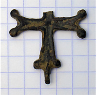 |
An acquisition was made to the benefit of the Historical Museum in Samarkand. This wearable cross was purchased from a private owner and given as a gift to the Museum where it is now exhibited together with the rest of Christian finds from the Samarkand region. |
12) v. Alexei Savchenko, Urgut', Encyclopaedia Iranica (www.iranica.com), forthcoming.
We owe our thanks to the following persons and institutions directly involved in the described Sergei Rovensky, communications technician, Samarkand Airport; Michael Jouravlev, lab assistant, ESAREX; Sattar Ghaffarov, field assistant, ESAREX and resident, mahalla (community) of Chor-Chinor, Upper Urgut for discovering the cave hermitage; Samarkand Regional Inspectorate of the Antiquities for taking every effort to safeguard the results of our work; Timurlan Khalikov (Timur-bobo, v. photo on the title page) for the efficiency of his prophecies.
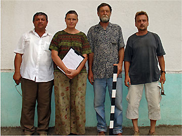 |
The
East Sogdian Archaeological Expedition, from left to right: Samariddin
Mustafakulov, archaeologist and anthropologist; Olga Jouravleva,
architect; Gennadiy Ivanov, archaeologist and topograph-er; Alexei
Savchenko, archaeologist and Orientalist. |
***
Fortsetzung des ProjektsDer Grabungsbericht für 2007 ist zurzeit nur in der englischen Fassung verfügbar.
Excavations in Urgut
June – July 2007
Progress Report
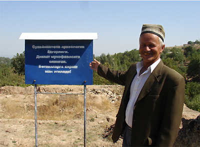
Sign board at the archaeological site
In June, 2007 the team continued excavations of Sulayman-tepa, the seat of the monastery of Urgut (Warkudah).
Initially the works concentrated beyond the main northern wall of the northern aisle. That is the sector where an habitational context was found during the previous campaign, in the form of a cooking place provided with several ovens (tandoors) and a cesspit (badrab). That was the long-awaited evidence of household activity of the monastery’s inhabitants.
In the course of the first two weeks the area of ca. 100 m2 was excavated, to reveal no presence of architectural structures or significant artefacts. It became clear that the northern aisle was the last room belonging to the church complex, and the area to the north of it was void of material remains except insignificant.
 |
|
| North-western sector of the dig beyond the last northern wall, facing N-E. |
In the light of this fact the nature of the northern aisle became more clear. On one hand, it has all the features of other two naves: same proportions and the altar-like structure in the eastern end. On the other hand, it lacks the rest of the architectural details – the steps and the narrowing (skakona) separating the chancel from the naos, the paved floor, or the decorations. Moreover, it is contiguous to a kitchen situated where the main nave has narthex – immediately before the entrance to the hall from outside.
Upon consideration we decided to identify it as a refectory which was considered to be a sacred place in some Eastern monasteries, and even in some cases was constructed as a full church with altar, where some services were specifically performed. All food served in the refectory should be blessed, and for that purpose, holy water was kept in the large pot found in one corner.
At this point the works were relocated to the southern sector where we continued to investigate the space beyond the main southern wall and to the west from it.
In the S-W sector, at floor level was found rectangular brickwork, at first glance resembling a funeral decoration. Upon removing, the surface structure gave way to a sealing made of large pieces of shale which once were solid slabs. Further down, at depth. 1,5 m were found remains of a large ceramic vessel dug into the ground. The bottom and the inside walls of the jar were covered with whitewash, with clear traces of claret-coloured depositions on it.
 |
 |
 |
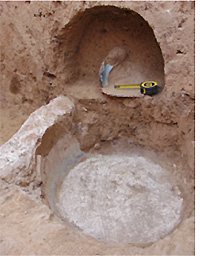 |
| Phases of the excavation of the wine cellar in the south-western sector of the site. | |
 |
|
Given the peculiar colour, it is most likely that the depositions were produced by must or wine. Putting Calcium hydroxide into wine is a centuries-old technique used to prevent the product from going sour by neutralising extra acid. The purpose to which the vessel had been put is thus clear: it is a wine jar, and the context in question is a wine cellar.1
Christian wine-making is attested at three other sites in Central Asia:
– winery in the monastery of Aq-Beshim (Suyab) in Qirghizstan;2
– jar with a Sogdian inscription containing a Syriacism (malpna – teacher or doctor) found at the site of Krasnaya Rechka in Qirghizstan;3
– bottom of a tub laid with bricks with carved crosses, found at a winepress in Aq-Tobe (Southern Kazakhstan).4
It should be said at this point that impressions of a stamp on several pottery items from Urgut are identical to those found in Aq-Beshim, Novopokrovka (Qirghizstan), and Krasna-ya Rechka (this last accompanied by the name of “craftsman Pastun”).5
On the top of the roof of the cellar was found a sealed pottery assemblage consisting of unbroken items and items that can be put together from fragments. Such assemblages usually belong to the time of destruction of an archaeological complex and testify to a sud-den and abrupt death of a monument.6
 |
|
1 Close semantic link between Christianity and wine-making is illustrated by the following passage by the Arab lexicographer al-Firuzabadi (AD XIV): “Mushammas is a name for wine. It is derived from shamms, the name given to the deacon of a Christian church and it means: a wine grown and nursed by a shamms” . – v. D. S. Rice, ‘Deacon or Drink: Some Paintings from Samarra Re-Examined’, Arabica 5 (1958), p. 22.
2 G. L. Semënov, Raskopki 1996-1998 gg., ‘Suyab. Ak-Beshim’, SPb. 2002, pp. 44-114. V. also: G. L. Semënov, ‘Mona-styrskoye vino Semirechya’, B. B. Piotrovsky Memorial Readings at the Hermitage, SPb. 1999, pp. 70-74.
3 A. N. Bernshtam, ‘Uygurskaya epigrafika Semirechya’, Epigrafika Vostoka 1 (1 947), pp. 34-37.
4 K. M. Baypakov, Srednevekovaya gorodskaya kul’tura Yuzhnogo Kazakhstsna i Semirechya, Alma-Ata 1986, p. 184.
5 V. A. Livshits, ‘Sogdiytsy v Semirechye: lingvisticheskiye I epigraficheskiye svidetel’stva’, Pis’menniye pamiat-niki I problemy istorii kul’tury narodov Vostoka. XV yearly conference at Leningrad Dept., The Institute for Oriental Stu-dies, December 1979, part I (2), Moscow 1981, p. 80.
6 V., e. g. V. I. Raspopova, Zhilishcha Pendzhikenta, Leningrad 1990, p. 17.
Since there is a good collection of stratified ceramics from the area, the complex found can be safely dated to the early XIII century, thus providing the terimus post quem for the mona-stery which probably corresponds to the Mongol taking of Samarkand in 1220.
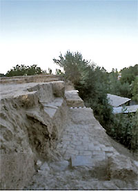
A number of fine cleanings was undertaken in order to establish and mark on the ground plan the main western wall destroyed by a seasonal mountain torrent between 1999 and 2004, yet before we were able to study the corresponding sector.
 |
|
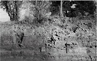
| Western slope of Sulayman-tepa in 1997 with the brickwork of the western wall clearly visible. | |
Apart from the excavations of the main site, we continued to map other local spots where Christian presence was attested in some way or another. The following sites were surveyed:
– Durmon-tepa in ca. 20 km to the west of Samarkand, where a mediaeval Christian burial was found in 1986, containing a cross of sheet gold. The cross had been sewn onto the dress of the dead, which probably indicated his priestly rank;7
– Arbinjan-tepa in ca. 80 km to the west of Samarkand, on the road Samarkand-Bukhara which once was a major trade route. Ceramic cast for moulding crosses was occasionally found there several years ago;8
– Kosh-tepa 2 in ca. 10 km from Urgut, where a rim of a jar featuring a scratched scene of baptism was found in 1973;9
– the area where a bronze cross was found in 2006 appeared to be flooded by the Chimkur gan water reservoir (ca. 70 km south of Samarkand).
– an area near Chinaz, Tashkent province was surveyed in order to pin-point the site of the other of the two Christian settlements in Mawarannahr described by Arab geographers (described separately, v. Addenda).
7 G. V. Shishkina, ‘Netorianskoye pogrebeniye v Sogde Samarkandskom’, Iz istorii drevnikh kul’tov Sredney Azii. Khristianstvo, Tashkent 1994, pp. 56-63. The item is kept at the Museum of the Peoples of the Orient in Moscow.
8 kept at the Institute of Archaeology in Samarkand.
9 M. M. Iskhakov, Sh. S. Tashkhodzhaev, T. K. Khodzhayov, ‘Raskopki Koshtepa’, Istoriya material'noy kul’tury Uzbekistana 13 (1977), pp. 88-97. Current location unknown.
 |
 |
| Main part of Durmon-tepa, facing north. | Arbinjan-tepa watered by the
river Narpay, facing south-east. lt was the main centre of the
resistance to the Arab conquest, and the last ruler of Sogd Divashtich
was executed here |
 |
|
| Kosh-tepa 2, now Iargely destroyed, looking south-east. | |
 |
 |
| The cast from Arbinjan-tepa. | Gravestone accidentally discovered
in Panjikant, Tajikistan, most probably of Semirechye origin. |
Permanent stainless steel big board was mounted at Sulayman-tepa explaining the significance of it and warning visitors against misconduct.
Twelve previously unknown archaeological sites dating to the early Middle Ages were dis-covered and mapped in the course of our surveys of the Urgut area.
Alexei Savchenko
Director of Research,
The East Sogdian Archaeological Expedition.
Conclusion of the excavation project at Urgut
After careful considerations it has been decided by the project leader Dr. Alexei Savchenko and the Society for the Exploration of EurAsia to conclude the fieldwork at Urgut since the project's objective set in early 2004 has been fully achieved with the discovery and excavation of the Christian church and monastery belonging to the Church of the East mentioned by the 10 th century geographer and historian Ibn Hawqal.
The results from this project will be published in scientific and popular media in due course which will be mentioned and possibly also published on the Society's homepage.Publications
-
Alexei Savchenko, Mark Dickens: Prester John’s Realm: New Light
on Christianity between Merv and Turfan. In: Erica Hunter
(ed.): The Christian Heritage of Iraq, Gorgias Press, 2009 (.pdf).
- Alexei
Savchenko: Östliche Urkirche in Usbekistan. In: Antike Welt, Philipp
von Zabern, Mainz, 2/2010
(.pdf).
| copyright by Gesellschaft zur Erforschung
EurAsiens | E-mail
| Home
| ![]()