Ausgrabung einer mutmasslichen buddhistischen
Anlage sowie einer sogdischen und karakhanidischen Siedlung
(Ab 2009 nur in englischer
Version verfügbar)
| 2004 | 2005 | 2006 | 2007 | 2008 | 2009 | 2010 | 2011 | 2012 | 2013 | 2014 | 2015 | 2016 | 2017 | 2018 |
| |
|
|
|
|
| |
|
|
|
|
| |
|
|
|
|
| |
|
|
|
|
| |
|
|
|
|
Ausgangslage
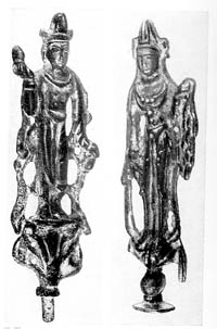
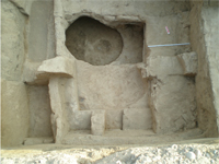
Novopokrovka II liegt am östlichen Rand von Bishkek, der Hauptstadt Kyrgyzstans, im Tal des Flusses Tschu. Die Fläche beträgt rund 14'000 m2. Das Objekt wurde schon 1953 von P.N. Kozhemjako1 mittels Sondierungen untersucht, wobei er zwei verschiedene Kulturschichten feststellte: Die untere datierte er ins 8.-9. Jahrhundert n. Chr., die obere ins 10.-12. Jahrhundert. In den Jahren 1965/66 wurden beim Grabungsort mehrere buddhistische Kleinfunde gemacht, darunter ein Steinrelief im Gandhara Stil, ein Kopf eines Buddha aus Lehm sowie Bronzefiguren.2 Auf Grund dieser Funde läßt sich vermuten, daß es sich bei Novopokrovka II um eine buddhistische Anlage, eventuell ein Kloster handeln könnte.
Bedeutung
Das Tal des Tschu-Flusses war einst ein Ballungsort buddhistischer Religiosität, denn unweit Novopokrovkas wurden einige buddhistische Klöster und Schreine entdeckt, darunter zwei Tempel in Ak-Beshim aus dem 6./7. Jahrhundert und zwei Heiligtümer in Krasnaja Retschka aus dem 8./9. Jahrhundert. Die Existenz mehrerer buddhistischer Heiligtümer im Gebiet des Tschu-Tals erstaunt insofern nicht, als hier eine der Routen der Seidenstrasse führte, die China mit Rom und Byzanz verband. Zwischen dem 7. und 9. Jahrhundert kämpften Westtürken, China, Araber und turkstämmige Karluken um die politische Herrschaft über das Tschu-Tal.
Zielsetzung
Die geplante Grabung soll die Natur der beiden Kulturschichten identifizieren und prüfen, ob sich eine buddhistische Funktionsanlage nachweisen läßt. Dabei wird von der Ummauerung des Geländes ausgegangen, so daß auch Ergebnisse über die Art der Stadtbefestigung zu erwarten sind.
Kurzbericht der Grabungskampagne 2004
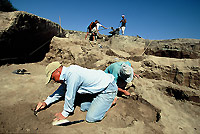
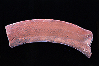
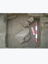
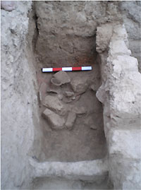
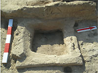
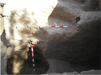
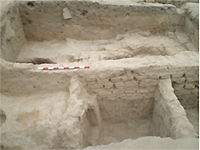
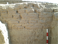
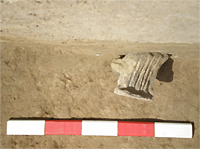
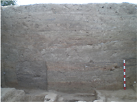
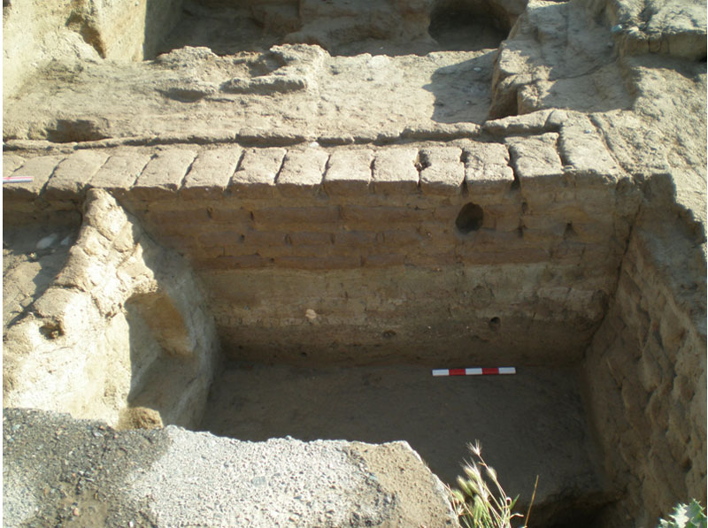
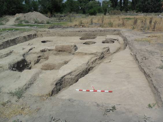
Die Ausgrabungen wurden vom 20. August bis 2. Oktober durchgeführt. Da das Zentrum des Zielgeländes durch heute mehrheitlich wieder abgerissene Überbauungen aus dem mittleren 20. Jh. stark beeinträchtigt ist, konzentrierte sich die Arbeit auf die gut erhaltene südöstliche Siedlungsmauer. Hier wurde ein unmittelbar an die äußere Siedlungsmauer angrenzender Wirtschaftskomplex freigelegt, vermutlich handelt es sich um den Markt, den Bazar, der aus mehreren Räumen bestand. Dort wurden Öfen und Müllgruben geöffnet. Durch die Münz- und Keramikfunde kann der Komplex ins 11. Jh. u.Z. datiert werden. Zu den interessantesten und sehr seltenen Funden gehören zwei Fragmente von großen Tongefässen, die zur Aufbewahrung von Getreide oder Wein dienten, sogenannte Chum . Die beiden Bruchstücke stammen vom oberen Gefäßhals und sie tragen eine Inschrift, wovon die eine als sogdisch identifiziert wurde. Die Ausgrabungen ergaben, daß die Siedlungsmauer in zwei Perioden errichtet wurde: Die erste Mauer wurde aus Stampflehm genannt Pachsa gebaut, die zweite aus ungebrannten Ziegeln. Zur genauen Datierung der Mauern gibt es heute noch nicht genug Materialien. Schließlich wurde auch ein Teil der Fassade des Eckturms freigelegt, der, wie die Mauer aus der ersten Bauperiode, aus Stampflehm erbaut war.
 |
 |
Abendzeitung Bishkek vom 27. September 2004, Auszüge:
" Die Geheimnisse des Hügels von Novopokrovka
Fast alle kennen die Anhöhe rechts an der Strasse Bishkek-Tokmak bei der Ausfahrt aus Bishkek. Hier stand früher Novopokrovkas Kulturhaus, das es nicht mehr gibt. Dafür haben auf dem Hügel mit großem Erfolg archäologische Ausgrabungen begonnen.
Wie der Vizepräsident der Akademie der Wissenschaften, Professor Vladimir Ploskih vermutet, sind schon die ersten Ergebnisse der Ausgrabungen sensationell. Es wurden zwei Fragmente von Chum entdeckt, der großen Gefäße zur Aufbewahrung von Getreide und Wein, die je eine sogdische Inschrift aus dem 8. bis 11. Jh. aufweisen. Es wurden in Kyrgyzstan im 20. Jh. nur rund zehn analoge Inschriften gefunden, die eine an demselben Ort wie die jetzigen beiden Funde. Dank dieser Inschrift weiß man, daß Novopokrovka mit der antiken Stadt Pakap identisch ist.
Der Ausgrabungsleiter von Novopokrovka, der Dozent an der Russisch-Kirgisischen Slawischen Universität Philipp Rott berichtet: Kyrgyzstan ist ein Klondike für Archäologen. Im Chu Tal [wo u.a. Bishkek und Novopokrovka liegen] sind über 20 mittelalterliche Städte und über fünfzig kleinere Siedlungen bekannt. Aber nur drei bis vier Städte blieben als Ruinen erhalten; auf den andern wurden Müllhalden, Friedhöfe oder sogar Militäranlagen errichtet. Auf Novoporovka's Hügel wurde früher ein Kulturhaus gebaut, worauf sich der Boden sehr bald zu senken begann. Deshalb wurde es wieder abgerissen. Dort haben wir begonnen zu arbeiten. Wir werden von der schweizerischen Gesellschaft zur Erforschung EurAsiens unterstützt . Außer den Chum-Fragmenten fanden die Archäologen im südöstlichen Teil der Anhöhe mächtige Festungsmauern. In der Zukunft sind neue interessante Entdeckungen zu erwarten.
Fortführung der Erforschung
Im Winter 2004/05 werden die entdeckten Funde wie beispielsweise rund zehn Kisten Keramikscherben, die Münzen und die beiden mutmaßlich sogdischen Inschriften weiter analysiert. Die Erforschung der Besiedlungsmauer und der früheren Baugeschichte des wirtschaftlichen Komplexes außerhalb der Stadtmauer wird 2005 fortgesetzt.
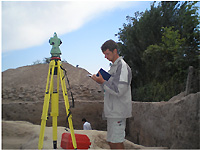
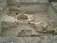
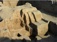
 Grabungsbeginn, im Vordergrund Ph. Rott. |
________________________________
1 Kozhemjako, P.N.: Rannesrednevekovje goroda i poselenija Tschujskoi doliny. Frunze 1959.
2 Staviskij B. J.: Sud'by buddhisma v Srednei Asii. Moskva 1998. S. 130ff.
Der Grabungsbericht für 2005 ist zurzeit nur in der englischen Fassung verfügbar.
Excavation 2005: Brief Report
Summary
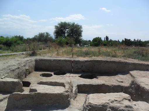
The excavation resumed in August/September 2005. The work continued at the south-eastern city wall where the excavation started in 2004. In rooms 1 and 4 (see plan) the lower strata were excavated, which belong to the Karakhanid period, 11 th century A.D. In room 4 a large clay vessel was found; a second large clay oven in room 9; the latter was surely a kitchen.
Excavations were continued around the corner tower found in 2004, which belongs to an older horizon and which was probably destroyed prior to the construction of the Karakhanid complex. No traces of fire were found. Two rubbish pits were found with shards. The bottom of the ground has not yet been reached.
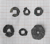
The north-western part of the excavation revealed an older than Karakhanid horizon, pottery vessels with more archaic shapes and two Turkish coins with Sogdian inscriptions. Such coins were used as off the 8 th till the 11 th century AD. The coins are presently analyzed. In this section at least two rooms (10, 11) were identified.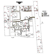 |
 |
|
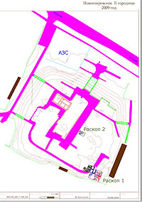
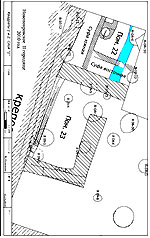
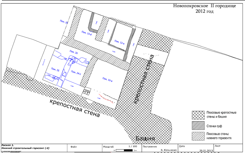
Plan Novopokrovka II |
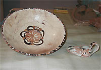
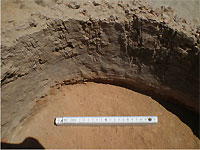
Two Buddhist figures found 1965/66 . |
|
 |
 |
|
|
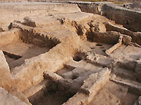
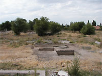
The excavation seen from the south . |
|
 |
 |
|
|
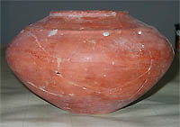
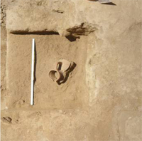
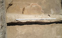
Jar found in 2005 |
Projektleitung
Philipp Rott. Diplom-Kulturwissenschaftler.
Universität Bishkek, Kyrgyzstan
Email: philipp.rott@firemail.de
Valery Kolchenko. Diplom-Historiker.
Wissenschaftlicher Mitarbeiter der Akademie der Wissenschaften
Archäologische Abteilung
Bishkek, Kyrgyzstan
Asan Torgoew
Wissenschaftlicher Mitarbeiter der Kunstkammer
Abteilung Sibirien
St. Petersburg, Rußland
PD. Dr. Dr. Wassilios Klein
Rheinische Friedrich-Wilhelms-Universität, Bonn, Deutschland
Email: wassilios.klein@t-online.de
Vorläufiger Bericht über die Grabung auf Novopokrovka II im Jahr 2006
von Philipp Rott
2006 wurden die Arbeiten auf der Siedlung Novopokrovka II fortgesetzt.
Der Raum 9 wurde völlig freigelegt (siehe Plan im Bericht 2005). Entlang der westlichen Wand wurde Tandyr 2 (Backofen) mit zwei Reservoirs für die Ablagerung von Asche und Holz ausgegraben. Dieser Tandyr ist gleich wie die Konstruktion des Tandyrs 1, der 2004 in diesem Raum freigelegt wurde (Foto 1 ).
 |
 |
| Foto 1. Raum 9 des karachanidischen Komplexes. Blick von NO. Tandyr 2 | Foto 2. Raum 11. Füllung (Stratigraphische Situation). . |
Im früheren, vor-karachanidischen Komplex innerhalb der Stadtmauer wurde die Freilegung der Räume 10-12 fortgesetzt. Die stratigraphische Situation in den Räumen 11 und 12 ist gleich. Die Verschüttung in den unteren Teilen der Räume wurde mit einer dicken Lehmschicht überdeckt, was bedeutet, dass es zwischen diesem Komplex aus höchstwahrscheinlich sogdischer Zeit und dem Komplex, der außerhalb der Stadtmauer freigelegt wurde, dem karachanidischer Komplex eine bedeutende Zeitspanne gab (Foto 2).
Zwischen der Epoche der sogdischen Siedlung und dem karakhanidischen Komplex war der Ort also vermutlich unbewohnt.
Der Raum 11 ist fast völlig freigelegt. Die Nordmauer aus Ziegeln ist spät bzw. nicht vom Boden aus gebaut, sondern von einer der Ebenen der vor-karakhanidischen Verschüttung. Die südliche Wand ist aus Pachsa (Stampflehm) gebaut. Die östliche Wand der Räume 10-12 sind Teile der Stadtmauer. Am Boden wurden drei Müllgruben ausgegraben.
Südlich des Raums 10 ist der Raum 11 freigelegt. Dieser Raum wurde in der Ecke der Stadtmauer eingerichtet, so dass die östlichen und südlichen Wände Teile der Stadtmauern sind. 2006 wurde in diesem Raum erst die nachsogdische Zwischenschicht entfernt. Raum 12 ist nördlich von Raum 11 (Foto 3).
 |
 |
| Foto 3. Raum 12, Bodenschicht, die Reste des zerbrochenen Chums . (grosses Tongefäss) | Foto 4. Raum 11, NO Ecke, Blick von W, Bodenschicht, ein keramisches Gefäß.. |
In der Verschüttung der drei Räume und in der Bodenschicht wurde Keramik gefunden, die prinzipiell andere Formen hat als im karachanidischen Komplex (Foto 4). Aber das Fehlen weiterer Münzen im Raum 11 (im Jahr 2005 waren zwei Münzen aus der Türkenzeit mit sogdischen Inschriften dort gefunden worden) oder anderer datierbaren Artefakten gibt noch keine Möglichkeit für eine feinchronologische Datierung dieses Komplexes. Relativchronologisch und ausgehend aus dem Charakter der Keramik wird er der so genannten sogdischen Phase der Kultur des Chu Tals zugeordnet.
Westlich der oben beschriebenen Räume wurden in der oberen Schicht, zum Teil eingetieft in die Zwischenschicht, weitere Stadtstrukturen freigelegt. Einer dieser Räume wurde zum Teil ausgegraben. Seine Wände (die nördlichen und östlichen) waren aus Ziegeln gebaut. Die relative Chronologie und der Charakter der Keramik weisen darauf hin, dass diese Struktur synchron mit dem karachanidischen Komplex ist. Diese Raumgruppe wurde ebenfalls erst gebaut, nachdem die frühere sogdische Siedlung von ihren Bewohnern verlassen worden war. Die architektonische Beziehung zwischen diesen Räumen und dem Komplex außerhalb der Stadtmauer ist noch nicht geklärt.
In den Räumen des karachanidischen Komplexes außerhalb der Stadtmauer wurde weiter gegraben (Foto 5) und einige Sondagen durchgeführt, um zu erkennen, ob es auch hier frühren Bauperioden gegeben hätte. Das Ergebnis ist in allen Fällen ungefähr gleich es gibt keine Baustrukturen unter den karakhanisischen Böden, die 2004-2005 ausgegraben wurden. Die ausgegrabenen Räume des Komplexes waren auf Schutt außerhalb der Stadtmauer errichtet worden.
 |
 |
| Foto 5. Raum 2, Füllung des Sufas, ein Bodenherd. | Foto 6. Baustruktur im östlichen Teil des Profils der Stadtmauer. |
Gearbeitet wurde auch im Schnitt der Stadtmauer. Es wurde hier fast überall der Mutterboden erreicht. Es handelt sich dabei um eine natürliche Terrasse, auf der die Siedlung entstand. Die Mauer des früheren Komplexes bzw. Siedlung wurde aus Pachsa gebaut. Später wurde sie mehrmals mit den zusätzlichen Ausmauerungen repariert. Nachdem die Siedlung eine Zeit lang verlassen war, wurde die Mauer in karachnidischer Zeit stark überbaut.
In östlichem Teil des Schnittes wurde noch eine Baustruktur gefunden (Foto 6), deren völlige Freilegung 2006 unmöglich war. Es handelt sich hier um eine Ziegelwand, die diagonal zur Stadtmauer lag. Das Fundmaterial in dieser Struktur ist gering; sie muss in die karachanidische Zeit zugeordnet werden.
Während der Grabung wurden keramische Komplexe gefunden, die in erster Linie aus den Müllgruben stammen. Unter den Metallfunden sind mehrere bronzene Schnallen zu nennen. In der oberen Schicht der Siedlung wurde ein wichtiger karachanidischer Fals, also eine Münze aus der karachanidischen Zeit gefunden, dessen Typ (Uzgend, 421) bis heute unbekannt war. Deshalb ist dieser Fund für die Numismatik von besonderer Bedeutung, eine entsprechende Publikation ist in Vorbereitung.
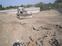
Schliesslich wurde die grosse Betonplatte aus den 1950er Jahren, welche das Stadtzentrum bedeckte und jede archäologische Arbeit dort verunmöglichte, mit Hilfe eines Bulldozers entfernt. (Foto 7)
 |
|
| Foto 7. Entfernung der Betonplatte aus den 1950er Jahren in der Stadtmitte. |
|
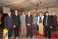
Am 21. Dezember 2006 wird im Nationalmuseum in Bishkek eine Ausstellung über die bisherigen Funde und daraus gewonnenen Erkentnisse von Novopokrovka II eröffnet. Diese Ausstellung ist auch eine Anerkennung des Projekts Novopokrovka II und der geleisteten archäologischen Arbeit. (Photo 8)
 |
|
| Photo 8. Bei der Eröffnungszeremonie der Ausstellung über Novopokrovka II, National Museum von Kyrgyzstan, Bishkek. V.l.t.r: Dr. Tabaldiew, Dr. Abetekow, Dr. Chargynow, Dr. Kamyschew und die beiden Projektleiter bei Novopokrovka II, Valery Kolchenko und Philipp Rott. |
|
Plan für 2007
Da die karakanidischen Strukturen ausserhalb und an der Stadtmauer
genügend erforscht sind und ausreichend karakanidisches Material
gewonnen wurde, werden sich die archäologischen Arbeiten ab 2007
klar in Richtung Stadtmitte konzentrieren. Die Arbeit an der Stadtmitte
ist dank der Entfernung der dortigen Betonplatte jetzt möglich.
****
Kurzbericht über die Grabung
auf Novopokrovka II, Kyrgyzstan
Kampagne 2007
Philipp Rott, Grabungsleiter
Die archäologischen Arbeiten konzentrierten sich während der Grabungskampagne 2007 (Objekt „Grabung 1“) auf die frühen Schichten des karachanidischen Komplexes außerhalb der Stadtmauer, da diese in Beziehung zu den ursprünglichen Fortifikationsstrukturen standen und Teilaspekte der Befestigung noch nicht abschließend geklärt waren. Indiziert war diese Maßnahme, da das Grabungsareal wieder zugeschüttet werden sollte.
Im Ergebnis lässt sich für die Grabungssaison 2007 festhalten, dass das Niveau zwischen dem Wohn- und Wirtschaftskomplex außerhalb der Stadtmauern und der Fläche des Grabens eine Verfüllung (ein Auffüllen eines Hohlraums mit fremdem Material) aufwies, die als Resultat der Zerstörung der Stadtmauer und der Fortifikationsbauten zu betrachten ist.
Diese Verfüllung war mit einer Steinschicht überdeckt worden,
die ein bestimmtes Ereignis im Leben der Siedlung markiert. Diese harte
Schicht von unterschiedlicher Mächtigkeit besteht aus einer Vermischung
feinen Lehms, Flusskieseln, kleinen Knochensplittern und Keramikfragmenten.
Es lässt sich vermuten, dass diese Vermischung durch Wassereinfluss
entstand. Ob dies mit einer Hochwassersituation zu verbinden ist, lässt
sich beim derzeitigen Auswertungsstand noch nicht beantworten. Foto
1 und 2 ist zeigen die stratigraphische Situation unter der Steinschicht.
 |
 |
| Foto 1: Stratigraphische Lage und Abfallgrube. | Foto 2: Stratigraphische Lage und Abfallgrube. |
Unter der Verfüllung ist ebenfalls die Oberfläche der Plattform zu erkennen. Bisher konnte nicht geklärt werden, ob die Siedlung auf einer künstlich angelegten Lehmplattform erbaut wurde oder ob es sich bei der Plattform um die Oberfläche der natürlichen Terrasse handelt. Die Analyse einer Probenentnahme steht noch aus.
Die Untersuchung der Verfüllung erbrachte wichtige Ergebnisse für das Verständnis der Existenz der Siedlung während der karachanidischen Zeit.
Es waren vor allem die zahlreichen Abfallgruben (mehr als 30!) und
ihre stratigraphische Situation, die zu folgenden Schlussfolgerungen
führten. Der ausgegrabene Bereich wurde am Anfang der zweiten Siedlungsphase
als Abfalldeponie benutzt. Die Abfallgruben, wie man auf dem Plan erkennen
kann, bilden Reihen, was auf eine regelmäßige Struktur (planmäßige
Anlage) hinweist. Die Abfallgruben haben unterschiedliche Formen, Größen
und Verfüllungen. Einige von ihnen waren in die Lehmplattform eingetieft,
andere schneiden sich, wie auf Foto 3 zu sehen.
Man will auf eine interessante Tatsache hinweisen. In vielen Müllgruben
wurden die Skelette von Hunden gefunden, die in voller anatomischen
Ordnung sind. Ein kultischer Zusammenhang ist nicht vorhanden. Auf dem
Foto 4 ist ein Beispiel davon zu sehen.
 |
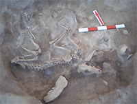 |
| Foto 3: Abfallgrube. | Foto 4: Hundeskelett. |
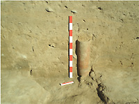
In einer der Gruben wurde ein Teil einer Wasserleitung (Kubur) gefunden
(Foto 5).
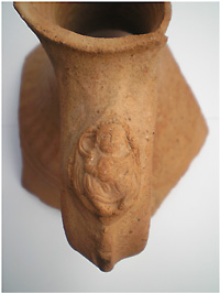
Außerordentlich interessant ist der Fund eines Gefäßbruchstückes
aus einer der Abfallgruben. Dabei handelt es sich um einen Krug, dessen
Henkel mit einer Terrakottenverzierung dekoriert ist (Foto 6). Die Verzierung
stellt einen männlichen Lautenmusikanten en face dar. Bis heute
sind nur zwei Vergleichsstücke aus dieser Region bekannt. Eine
davon wurde von A.N. Bernstam mit dem Buddhismus in Zusammenhang gebracht,
was noch offen bleibt. Entfernte Analogien gibt es zu Ost-Turkestan
und Mittelasien. Ein Aufsatz des Grabungsleiters wird auf den Sommer
2008 vorbereitet.
 |
 |
| Foto 5: Wasserleitung (Kubur). | Foto 6: Krug mit Terrakotta-Verzierung eines Lautenmusikanten. |
Was die Bauaktivität in diesem Bereich betrifft, so lässt
sich schon heute vermuten, dass sich die Siedlung weiter ausbreitete
und der Abfallgrubenbereich mit einem Wohn- und Wirtschaftskomplex überdeckt
wurde.
Während der Grabungskampagne 2007 wurde die Siedlung topographisch komplett aufgenommen.
Für die Grabungskampagne 2008 ist eine Fortsetzung der archäologischen
Arbeiten mit den Ziel, die Beziehung zwischen den beiden Siedlungsphasen
zu untersuchen. Die Forschungsarbeiten werden sich auf die sogdische
Schicht konzentrieren. Dafür bieten die 2007 gewonnenen Daten und
Materialien eine solide Grundlage.
 |
|
| Photos © by Philipp Rott, Christoph Baumer |
|
Bericht über die Grabung Novopokrovka II 2008
Während der Grabungskampagne 2008 richtete sich die Aufmerksamkeit der Arbeiten vorwiegend auf die weiteren Untersuchungen der im Jahre 2007 freigelegten Räume innerhalb der Stadtmauer, die zum früheren Bauhorizont I (so genannte sogdische Phase) gehören. Außerdem wurden 3 neue Flächen (1-3) bzw. Quadrate (5 x 5 m) angelegt, wobei hier vorwiegend die oberen Schichten untersucht wurden.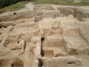 |
|
|
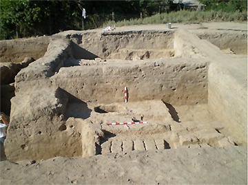
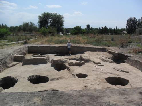
| Abb.1. Gesamtblick auf die Grabung 2008. Blick vom Osten |
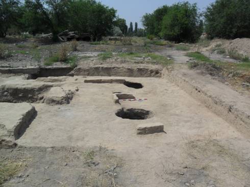
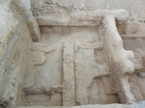
Die Untersuchung der Räume, die sich östlich entlang der Stadtmauer befinden, hatte als Ergebnis die teilweise Freilegung des Raumes 10 zur Folge. Die Funktion dieses sich an der Ecke der Stadtmauern befindenden Raumes, blieb noch unklar, so dass weitere Grabungen notwendig sein werden.
 |
|
|
| Abb. 2. Raum 10 und 9. Blick vom Norden |
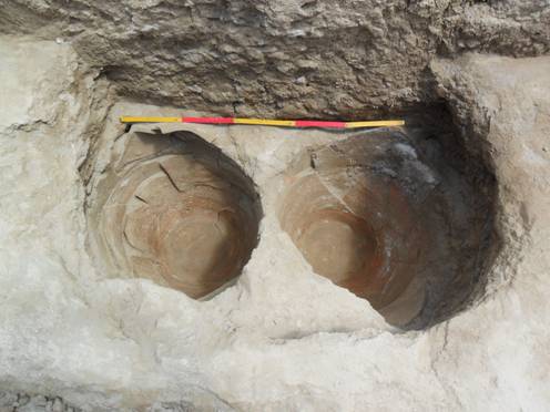
Im Raum 12, der ebenfalls nur zum Teil freigelegt wurde, wurde unterhalb des Fußbodens eine eingetiefte Grube (Nr. 24) entdeckt, die einen für Cu-Tal einzigarteigen keramischen Komplex enthielt. Neben frühen Gefäßformen große Chums und Gefäße mit Kesselfunktion ist ebenso ein Pokal zu nennen, der zweifelsohne ein Unikat für die Region darstellt. Einzigartig ist auch das Fragment eines so genannten Rauchgefäßes mit einem zickzackförmigen Rand.
 |
|
|
| Abb. 3. Der Pokal aus der Mullgrube 24 |
Abb. 4. Fragment eines sogenannten Rauchgefäßes. |

Die Münzfunde von 2005 und die relativ chronologische Fakten lassen den Bauhorizont (Räume 10-12) ins 8. Jh. datieren.
Es ist die Aufgabe der nächsten Grabungskampagne, die oben genannten Räume vollständig freizulegen um ihre Funktion festzustellen.
In den Flächen 1-3 wurden vorwiegend die oberen Schichten freigelegt, die von zahlreichen Gruben durchgeschnitten wurden, wodurch die Kulturschicht sehr stark zerstört wurde. Problematisch ist jedoch, dass die oberen Schichten durch den Bau des Kulturhauses entfernt bzw. zerstört wurden und es bleibt deshalb unklar, von wo bzw. von welchem Horizont die Müllgruben eingetieft wurden.
Stratigrafische Situation ist folgende: Unter der modernen Schicht liegt eine Schicht, die von späteren Müllgruben durchgeschnitten wurde. Das Material aus den Gruben lässt weder eine chronologische noch eine kulturelle Abfolge erkennen, da es nicht sehr repräsentativ ist.
Unter dieser Schicht liegt der Bauhorizont IIa, der sich mit karachanidischer Phase zu korrelieren ist. Die Baustrukturen stellen dabei die Räume dar, deren Funktion nicht klar ist. Die Reste der Bronzegießerei, die in ihnen gefunden wurden, sowie ihr provisorischer Charakter, lassen vermuten, dass es sich hier um Werkstätte handelt.
 |
 |
|
| Abb. 5. Die Baustrukturen des Horizontes II. Im Vordergrund ist eine Lehmziegelplattform zu sehen. |
Abb. 6. Die Baustrukturen des Horizontes II bzw. Räume 13-15 im Vordergrund. |
Die Räume bzw. deren Böden überdecken die massive Schicht, welche die Verwüstung der Siedlung markiert. Sie hat eine heterogene Struktur. In dieser Schicht kommen Tonscherben und Tierknochen vor. Markant ist dabei eine große Zahl der Fragmente der so genannten Ständer, die grob angefertigt sind.
 |
 |
|
| Abb. 7. Nordmauer des Raumes 14. Struktur der Mauernaufführung. Die Mauer überdeckt der Verwüstungsschicht. |
Abb. 8. Das Fragment eines so genannten Ständers in situ |
Diese Schicht ist genauso mit Abfallgruben durchgeschnitten, die wiederum die unteren Schichten durchschneiden. Die Abfallgruben wurden aus verschiedenen Leveln bzw. Unterschichten eingetieft und enthalten Keramik und Tierknochen.
 |
 |
|
| Abb. 9. Fl. 2. Die stratigrafische Situation. Die Wüstungsschicht überdeckt Horizont IIb. |
Abb. 10. Baustrukturen der Horizonts Ib |
Darunter wurden Baustrukturen freigelegt, die Einfüllungen der Räume des so genannten sogdischen Bauhorizontes (Horizont I) überdecken. Sie stellen den Horizont Ib dar. Die Erhaltung dieser Strukturen lässt keine Rekonstruktionsvorschläge zu. Der Horizont I wurde während der Kampagne 2008 nur zum Teil freigelegt.
 |
||
| Abb. 11. Die Absenkung der Mauer ist zu sehen. |
Die Ausgrabungen 2008 haben ergeben, dass es zwischen dem Bauhorizont I bzw. Ib und II eine Verwüstungsperiode gab. Relativ stratigrafisch entspricht diese Periode der Zeit zwischen dem 8. und 10. Jahrhundert. Historisch ist diese Zeit mit der Invasion der Karluken zu verbinden. Ob dies wirklich eine große Auswirkung auf die Entwicklung der Stadtkultur in der Region hatte, ist immer noch diskutabel und kann nur dann beantwortet werden, wenn eine Reihe weiterer Siedlungen großflächig ausgegraben sein wird. Was zur Verwüstung auf dem Siedlungsterritorium Novopokrovka II in dieser Zeit führte, bzw. was dafür verantwortlich war, ist noch unklar.
Weiterhin bleibt unklar die Frage, welche Funktion die Anlage ursprünglich hatte. Um die vorhandenen chronologischen Beobachtungen zu überprüfen, bzw. ursprüngliche Funktion der Anlage festzustellen sowie weitere Fragen der Siedlungsentwicklung zu beantworten, wurde entschieden während der Kampagne in Jahre 2009 zwei neue Flächen bzw. Quadrate im zentralen Teil der Siedlung zu öffnen.
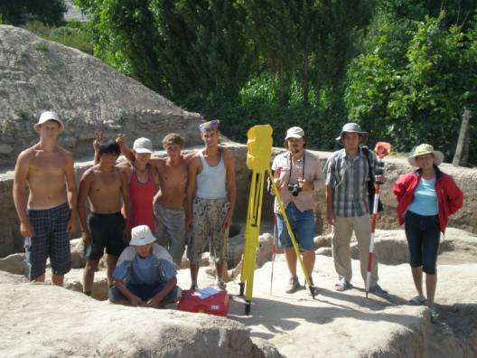
Abb.12. Grabungsteam 2008.
Report on the Excavation of the Novopokrovka II
Settlement 2009
Philipp Rott
(Zurzeit
nur in englischer Version verfügbar)
In 2009, work was performed at two locations: Excavation I on the southeast
corner of the settlement, where work has been done since 2004, and Excavation
II in the central part of the settlement. The second instance deals
with two squares measuring 2.5 x 2.5 meters. (Maps 1 and 2)
Excavation I.
|
|
|
| Fig. 1. View from the south. Rooms
13 and 15. The structure of the wall to the north is visible. |
Room 15.
In 2009, this room was further excavated. It was discovered that its
east wall was built of clay bricks (1,5). It covers the deterioration
layer, which is characteristic for the entire area. The north wall is
leaning against the east wall. The floor in this room was not found,
its destruction can be explained through the soft structure of the deterioration
layer.
The north wall is built of clay bricks, with measurements of 50 x 24
x 9 cm.
Through the uncovering of the deterioration layer, a row of refuse pits
was found.
 |
 |
|
| Fig. 2. Rooms 13-15. Refuse pits 1-3/2009 |
Fig. 3. Overview of the
area excavated in 2009. Room 16 is in the foreground |
To the north, a further room (Room 16), i.e. its southern wall, was
uncovered. Its correlation to Rooms 13-14 is still unclear. In the deterioration
layer of this area, a row of refuse pits was uncovered that reaches
down to the lower layers. Out of Refuse Pit 24/2008, which was completely
uncovered in 2009, a number of heavily corroded coins of the Tyrgesh-type
(most of the coins have a diameter of up to 1 cm) were brought out.
(Fig. 4) In addition to the coins, remnants of bronze casting (wire,
etc.) were found in this pit. Almost all of the refuse pits that can
be correlated with the deterioration layer, contain fragments of ceramics
and animal bones.
 |
||
| Fig. 4. Tyrgesh-type coins |
Room 12.
In 2009, Room 12 was completely uncovered. The following results were
obtained.
 |
 |
|
| Fig.5. Room 12. View from the south. |
Fig.6. Room 12. View from
above. |
The north wall of this room was built of bricks. Additional walls belong
to the beginning period of this complex, i.e. to the earlier horizon
on this settlement, therefore to the 6th-7th cent. A.D. They were built
of pachsa. Along the south and west walls, there are sufas. These sufas
indicate they functioned as residences, which could have changed, however,
in the course of time. It was discovered that they were built after
a certain model. This concerns a special technique, in which the front
wall consists of clay bricks that are laid cross-wise.The maximum height
of the sufas is 38 cm.
The wall in the centre of this room formally divides it into two smaller
rooms: 12 a and b. It was built from clay bricks and belongs to a later
building period than the pachsa walls. Its maximum height is still 80
cm, its thickness – 50 cm. Its central section was destroyed by
a later refuse pit 15/2009. It covers the sufa, which is located along
the western wall.
 |
||
| Fig.7. Fragment of a vessel on the
sufa of Room 12. |
In the north wall of the room is a passage to the north that leads
along the eastern wall. To the west, this room connects with Room 16a,
which is only marked by a passage. This passage also runs along the
southern wall. The entire concept, i.e. function of this room remains
unclear, not least because of its destruction by later refuse pits.
This question can therefore only be solved, after Room 16, which is
situated west of it, is excavated.
Excavation II.
Excavation II is located in the central part of the settlement. A square
of 5 x 5 meters was outlined in squares of 2,5 x 2,5 m. These were named
1a, 1b, 1c, 1d. In 2009, squares 1a and 1d were examined. East of these
squares, two additional squares were outlined. These were named 2a and
2c. Square 2c was excavated.
 |
||
| Fig.8. The two squares of excavation
II investigated in 2009 |
In square 1d, two building periods were identified. Here we are dealing
with the upper structures, severely damaged by a house of culture built
in the 1950s, the correlations of which have remained unclear. One can
only speak of a wall, built of clay bricks and running in a north-south
direction with a small deviation. The height of this wall is 10 cm,
the thickness – 12 cm. The length of the bricks is 40 cm. Because
of this wall, one can speak of two rooms, Room 1 and 2. Additional constructions
that could be connected to this wall, were not determined.
The fill in both rooms is relatively crumbly, with fragments of ceramics,
clay bricks, as well as animal bones and pieces of coal.
In Room 1, a very good floor was uncovered. On this floor, a Karachanid
coin was found, which dates this building period in the Karachanid period.
Very good flooring was also uncovered in Room 2. The ceramic complex
is very poor.
 |
 |
|
| Fig.8. Square 1d. The wall between
Rooms 1 and 2 covers a destroyed tandoor (oven). View from the east. |
Fig.9. Square 1d. The wall
between Rooms 1 and 2 covers a destroyed tandoor I and an ash
reservoir to the north of it; a salt line marks its outer limits.
View from above. |
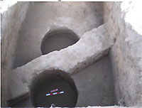
Included in the lower building period (second building period) are additional structures: a room which functioned as a kitchen (Room 3). It contains a tandoor and a floor oven with an ash reservoir, the upper parts of which were destroyed through later building work, so that only their lower parts were found intact. The tandoor has a diameter of 64 cm, its height is 30 cm. In the fill of the tandoor, remains of a water jug were found.
 |
||
| Fig. 10. Character of the tandoor walls. |
The floor oven has an opening towards the west. The measurements: north-south
– 27 cm, heigth – 20 cm. North of the oven is a reservoir,
which was used for ash. A similar kitchen room was discovered in 2004
near Room 9.
The floor of this room has a tilt towards the north.
Beneath this floor lies a very soft fill with many ceramic fragments,
which can indicate a refuse area in this location. Among the latter
are chums and other ceramic forms. The fill is a spongy loam with pieces
of the tandoor wall and pieces of coal.
 |
||
| Fig. 11. Square 1d. Room 3. View from
the east. |
In Square 1a, a row of refuse pits was uncovered, which had been deepened
by the upper layer. Additional work, i.e. examinations of lower layers
on this level are planned for 2010.
The most important results of the season are the following:
A large room (Room 12), belonging to the original period of the complex
within the city walls, i.e. the earlier horizon, was completely uncovered.
The function of this room is not yet totally clear, since it is not
known, how this room can be correlated with others next to it. To clarify
this is one of the goals for Season 2010. Through the excavation of
a number of additional rooms (Rooms 10, 11) along the eastern city wall,
it will be made clear, how this important area, which was connected
to the fortification, can be viewed. Unique ist the ceramic complex
that stems from this horizon. For the Chu-Valley, this may be the richest,
closed complex containing forms that indicate relatively distinct relationships
with the Syr-Darya region. In Sogd, the ceramic forms obtained here
do not find any clear parallels. Practically for the first time with
regard to the Chu-Valley, we can thus speak of an earlier building technique.
The find from Refuse Pit 24/2008 can point to a local coin production,
which can be confirmed by a further examination of the coins.
Work at Excavation II has shown that the cultural layer in the central
part of the settlement is intact, inspite of the now-torn-down culture
house from the Soviet period. A later layer, belonging to the Karachanid
period, was for the most part uncovered. In 2010, the lower layers,
which might be connected to an assumed Buddhist complex, will be examined.
The results that were achieved in Excavation II confirmed, that the
entire area of the settlement was used as a living area in Karachanid
times.
The accomplishments of this season again have had great resonance in
the local and international press. In the major newspapers, half- and
full-page reports were featured. In addition, there are a number of
publications in the Internet.
Scientific publications will follow. In the series „Materials
and Investigations in the Archaeology of Kyrgyzstan) (starting in 2010),
the publication of yearly excavation reports is planned.
The results of the excavations were presented in a lecture at the Institute
for Religious Science in Bern, November 2009. A lecture on the results
of the excavations on Novoprokrovka at the DAI German Archaeological
Institute) is planned for 2010.
In addition, the settlement was recorded as part of the summer school
program of DAAD. (Human-Environment-Interaction on the Silk Roads: An
Interdisciplinary Summer School August 2 – 18, 2009.
| http://www.uni-tuebingen.de/ETHNOLOGIE/praktika/sommerschule.html |
 |
 |
|
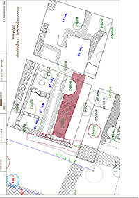
| Map 1: Total site |
Map 2: Total site |
 |
 |
|
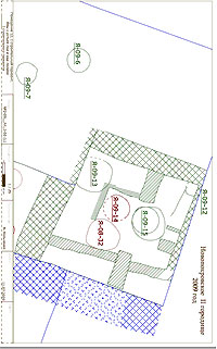
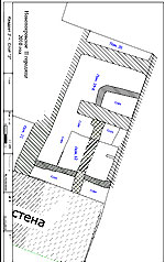
| Plan 3: Excavation I |
Plan 4: Room 12.5 |
 |
||
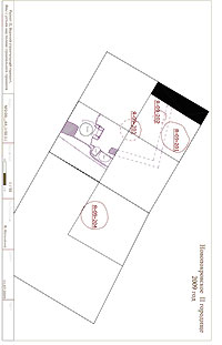
| Plan 5: Excavation II |
The archaeological report on the excavation
of 2010 in Novopokrovka II
(Zurzeit
nur in englischer Version verfügbar)
The research of Novopokrovka archaeological group of the Institute of
History of National Academy of Sciences of Kyrgyzstan was focused in
2010 on the excavation of the living structures inside the ancient town
wall and its system fortification (Excavation I). In the centre of the
ancient town (Excavation II), the technical works (measurements), which
were conducted by the owners of the site at the time of our excavation
(the territory of the ancient town is now a privacy) forced us to postpone
our excavation in the centre to 2012.
The following works were done:
1. Living quarters:
– research of building horizon 1 in the squares 1 and 2;
– research of low building horizon in the square 3 (rooms 19c
and and 20).
2. Fortification:
– research of the outside surface of the ancient town wall at
the point of its connection with south-eastern corner tower: three periods;
– research of the structure of the ancient town wall.
The research of the living structures in the squares 1 and 2 made clear
that the wall 1, of which remained only one layer of bricks, is higher
than the base of other walls of this room, so it was built later, from
the building horizon 0.
After this wall below its level was researched and moved off the new
room 23 was formed. Its northern, western and eastern walls are built
from bricks (45-46 x 25-26 x 9-10 cm). The height of this is 2-4 layers
of mud bricks. The southern wall of this room is the inside surface
of the ancient town wall. The western and eastern walls are put against
it. The entrance to this room could only be a place in the northern
wall, but this wall was extremely destroyed by the latest rubbish pits
(08-2, 09-11![]() 10-15). The floor
of this room has no clay covers. The finds are some fragments of ceramics.
10-15). The floor
of this room has no clay covers. The finds are some fragments of ceramics.
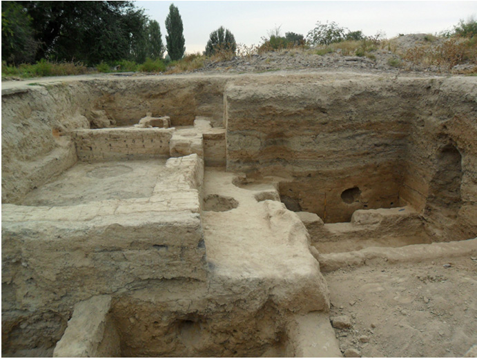
Photo 1. Rooms 19-23.
The works in the square 2 focused on the research of the construction
of the room 16 of horizon 0. The excavation of this area brought some
new constructions including the walls. Due to these structures the new
room was formed: 22. This room has a sufa. The filling of the first
southern sufa includes fragments of ceramics, a fragment of a bronze
buckle and a coin of unidentified type, both in very bad condition.
The other sufa lies along the eastern wall.
The tandyr was found here. It is formed as a block, which is already
known from another rooms. This block includes a tantyr itself and reservoir
for keeping ashes. The diameter of tandyr is ca. 80 cm. It was found
that the tandyr’s block was built at the same time with eastern
sufa of this room.
 Photo 2. Room 21-22. |
 |
|
| |
Photo 3. Room 22. |
 |
||
| Photo 4. Room 22-23. |
. |
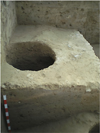
The works in the square 3 focused on the room 19/19c found 2009. The size of this room: 3,7 x 2,7 m. The northern wall of this room is built from the mud bricks (50-52 x 22-24 x 8-9 cm). The surface of this wall has a plaster. The eastern wall is adjacent this room 12. It was found that the maximal thickness of this wall is 75 cm. The western wall was extremely destroyed by the latest rubbish pit 08-19. Only the northern part of this wall is remained. Its maximal thickness is 60 cM.
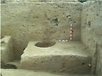
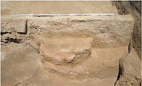
This room 19c has sufas along three walls: northern, southern and eastern. Their size: (1,10, 1,05 and 0,57 m). The height is 20 cm. In the centre of this room is found a square podium, which height is also 20 cm. Its base size: 80 x 90 cm. Research of all these sufas has shown that they all are monolith and built from pachsa.
The floor was covered with clay plaster.
The only entrance to this room was found; it is located in the eastern wall and connects this room with room 12. Its maximal 1,1 m.
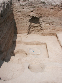 |
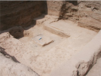 Photo 6. Room 19c. |
|
| Photo 5. Room 19c. |
The area to the west of the western wall of rooms 19c and 19d was called as room 20. In the south-eastern corner of this room the rubbish pit 10-7 was found. It was dropped from the level c. Its construction destroyed the southern and eastern walls of the room. In 2010 it was partly excavated. Within the content of filing were some fragments of ceramics and pieces of mud bricks.
 |
||
| Photo 7. Room 20. |
. |
Fortification
The building history of the town wall and fortification
in general was researched mostly during the first years of excavation
on Novopokrovka II. So, it was stated that the wall consists from the
base made from pachsa and some mud brick walls built to it from the
outside later.
In 2010 we got some new and detailed information on this aspect.
In the pachsa base of the wall there are two horizontal layers to see.
Their height is ca. 1 m. But there are vertical lines. The surface has
a horizontal incline 70º.
The tower has the same type structure. The lower layer of the tower
is put against the wall, and the upper is on the contrary. So, we can
say that both these structures were built at the same time.
The tower is put against the wall absolutely perpendicular.
The above mentioned two layers of pachsa were covered with another layer
of smaller pachsa-blocks. The height of this layer is ca. 30 cm and
it is well visible only in the area of the tower (to rubbish pit 10-8).
Due to these works we could understand the correlation of the latest
mud brick walls, put against the pachsa base of the town walls. The
construction of these mud brick walls was studied in detail: the size
of mud brick etc.
 |
 |
|
| Photo 8. The structure of the town
wall. |
Photo. Rubbish pits 10-4
and 10-6.. |
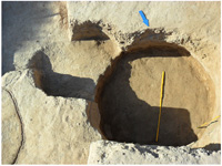
The 15 new rubbish pits were found 2010.
Their metrological characteristic is in the table.
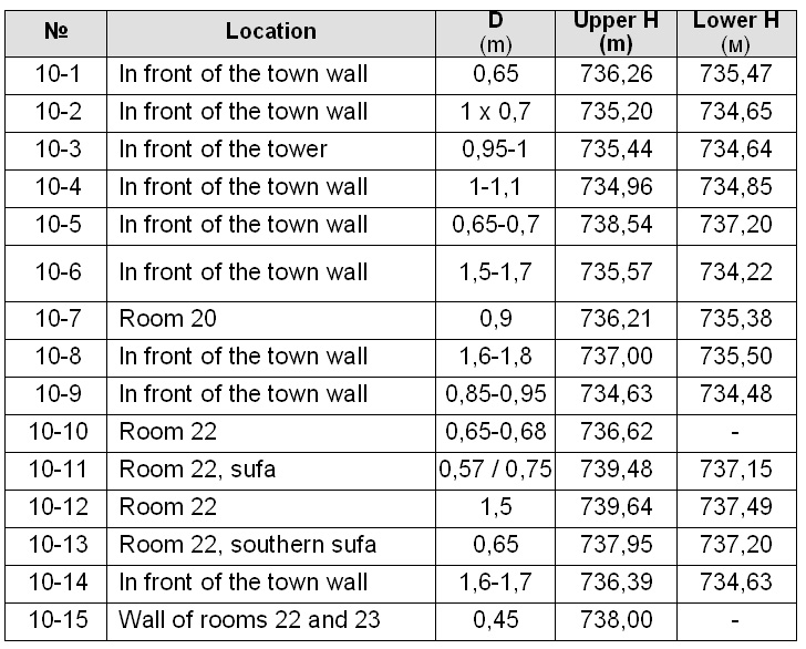
Unfortunately, most part of these rubbish pits as well as the filling
of the excavated rooms did not contain interesting finds.
The work of 2011 will focus on the partly excavated 2010 rooms of Excavation
I and structures of Excavation II in the centre of the site.
Philipp Rott, 15 January 2011
 |
 |
 |
 |
| NP2-20-3.PDF | NP2-2010_common_plan.pdf | NP2-2010_layer_1.pdf | NP2-2010_layer_3_rooms19d+12+20-1.pdf |
Report on excavations at Novopokrovka II in 2011
Philipp Rott, Valery Kolchenko
The archaeological works were carried out in 2011 on the surfaces I and II.
On the surface I (south-eastern part of the hill) Quadrant I was further deepened.
Here the walls of the room 23 were dismantled, which was already exposed in 2010. Under the floor of this room seven rubbish pits were found, which contained mainly pieces of building materials: unfired brick and pachsa and also a few ceramic fragments. All of them are not deep, their depth is about 0,4 m. And all of them belong, as one might expect, to the same level. The building history of this area looks as follows: First, the rubbish pits were deepened into a unbuilt rubbish area, then before to the construction of the room 23 this area was leveled and the top parts of the rubbish pits were destroyed.
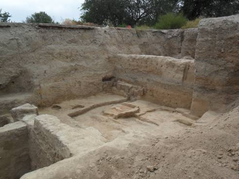
Photo 1. Room 23 and 24. Overall view from the south-east.
Here is something deeper, a further wall was discovered, it belongs to the room 24, that is located underneath the level of the room 23. This room was excavated down to the floor. Along the southern wall, which is also the settlement wall and the eastern wall the Sufas were exposed, their height is about 20 cm and the width is 1,2 m. Their surface and also of the floor of this room is relatively smooth. The western wall of this room is not found, it must be outside the area.
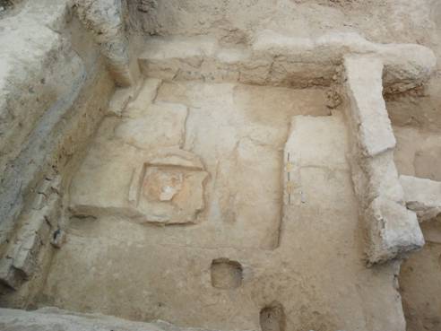
Photo 2. Room 23 and 24. View from above.
The room 24 is square in shape. Its size is (not fully excavated): NS - max. 5,17 m, WE - max. 4,4 m. In this room was only found a passage that runs along the northern wall of the room. Its width is 65 cm. The northern and eastern walls of this room are constructed from pachsa and at an earlier time. They are plastered.
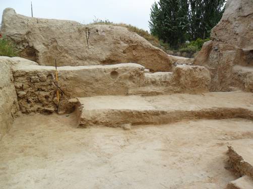
Photo 3. Room 24. Passage
Approximately in the center of the room stood a tandyr, a free furnace. Its base consists from three burnt bricks including brick fragments (36 х 18 х 4 cm), which lie on a NS line.
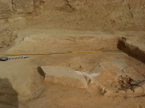
Photo 4. Construction of the furnace in the room 24.
On the floor near the tandyr a Türgesh coin was found (d = 2,4 cm). Also here is a fragment of a bronze buckle (the two pieces are currently being restored). Among other finds, some fragments of pottery are to mention.
The room 24 corresponds to the level of the room 19c, which is located to the north of it.
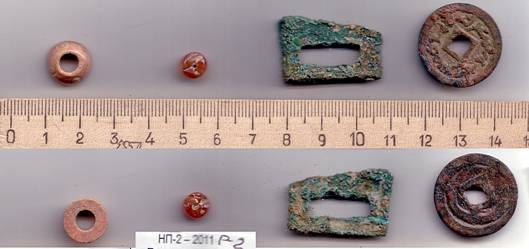
Photo 5. A Türgesh coin and other small finds from Room 24.
The filling of the spaces between the bottoms of the rooms 23 and 24 includes the ashlayers. In the southern area of the room a block of unfired bricks was found. It lies approximately horizontally with a small inclination to the north and was followed on 2 meters. The position of the bricks in the block is reminiscent of an arch but it lacks any trace of curvature. The disassembly of this block will continue in 2012, which provides more information.
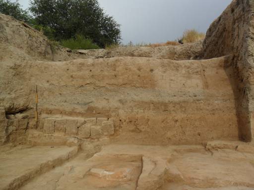
Photo 6. Room 24. Block of unfired brick.
There were also rooms 10 and 11 investigated further (voluntary work for documentation), that belong to an earlier horizon at the settlement.
The room 11 connects the city wall, in the east it borders on the room 24, in the north to the room 12. Its size: 4,3 х 1,8 to 1,9 m. This room has two passages: the first one goes along the northern wall to the west, the second one goes along the western wall to the south.
The room 10 is rectangular in shape and has the following size: 4,15 to 4,2 х 1,7 to 1,75 m. It has a single passage along the western wall to the north.
Parallel parts of the city wall were examined further. Ist strucure was documented.
On the surface II in 2010 interrupted the work continued. Three quadrants, which were moved here, were combined into one large area, which currently amounts to 10 x 10 meters. In 2011, on the whole surface the upper destructive layers were removed. Underlying layers were examined. Several walls were found here.
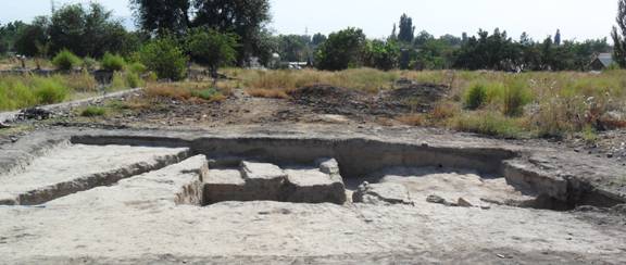
Foto 7. Overall view of the surface II.
Metrological data on the rubbish pits
Arch. Name |
Place |
D fix. |
Н fix. (m) |
Н |
Depth fix. |
Я-11-1 |
Under the floor of the room 23, southern wall |
1,24 / 1,1 |
737.199 |
736.397 |
0,8 |
Я-11-2 |
Under the floor of the room 23, northern wall |
1,35-1,55 |
736.75 |
736.36 |
0,4 |
Я-11-3 |
Brickwall |
1,0 |
736.693 |
735.742 |
0,95 |
Я-11-4 |
Under the floor of the room 23, eastern wall |
0,7 |
737.135 |
737.185 |
0,05 |
Я-11-5 |
Under the floor of the room 23, north-east |
1,1 |
736.802 |
736.680 |
1,12 |
Я-11-6 |
Under the floor of the room 23, eastern wall |
1,35 |
736.903 |
736.646 |
0,25 |
Я-11-7 |
Under the floor of the room 23,western wall |
0,85 |
737.185 |
736.780 |
0,4 |
Я-11-9 |
Under the floor of the room 23, nothern wall |
0,85 / 0,9-1,1 |
736.810 |
736.260 |
0,56 |
Я-11-10 |
Southern settlement wall |
0,85 |
737.381 |
734.473 |
2,9 |
Я-11-11 |
Room 10, floor |
0,45 |
735.228 |
734.455 |
0,77 |
Я-11-12 |
Settlement wall |
0,8 |
736.874 |
736.367 u. deaper |
>0,5 |
In 2012, the works will be focused on the surface II, where the goal is to investigate the lower strata of the settlement. Parallel smaller works must be carried out on some structures of the surface I, which have remained unexplored.
15 January 2012
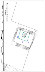
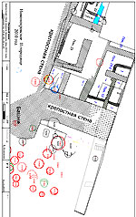
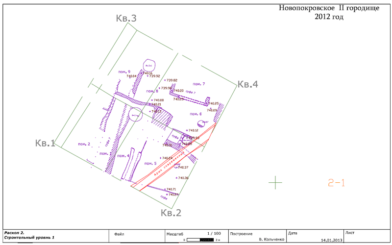
Plan of excavated sectors and rooms
The south-easter sector (PDF)
Rooms 10-12 (PDF)
Room 24 (PDF)
Report on the archaeological excavation on Novopokrovka II in Kyrgyzstan in 2012
Valery Kol’chenko, Philipp Rott
Excavation II
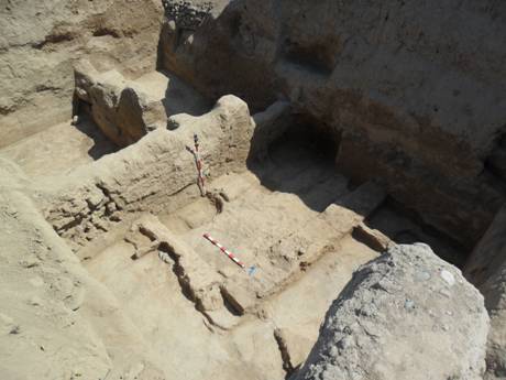
The focus of the works of 2012 (18.06.-20.07.) was concentrated on the Excavation II in the centre of the settlement, so on the northern and eastern quadrants of this area (Pic. 1).
Pic. 1. General view of the Excavation II. View from the North
In the northern part of Excavation II under the destructive modern layer the walls of some rooms of the first building period (horizon I, so called kharachanid time, 10-12 centuries) building period I (the date is still related) were found (rooms 6-8/8а) with some restructuring (building period II, the data is still related). The rooms were on the line North-South. Their walls are extremely destroyed. It could be found that they were built from one line of mud bricks. The floors of all these rooms were partly disturbed with the rubbish pits, which went from different levels. Such situation is typical for this time (10 century?, it is also related) on this settlement. The same picture we could see at the Excavation I (Pic. 2).
Pic 2. Rooms (6-8/8а). Remains of the walls. View from the East
In the year 2012 13 rubbish pits at the area of the Excavation II were found. Almost all of them were completely excavated. They were filled with organic materials, including animal bones, fragments of ceramics, including some whole ceramic vessels, coming for example from the rubbish pit 12 (Pic. 3), slag and fragments of building materials: mud and unfired bricks. In the rubbish pit 2/2012 an unidentified bronze coin was found.

Pic. 3. Filling of the spoil pit 12. Ceramic vessels
In the rubbish pit 6/2012 the fragments of the fired oven were found. It was surely the oven, which after usage was thrown down into this pit from the floor of room 6 (Pic. 4).
Pic. 4. Fragment of the fired oven, found in the rubbish pit 6/2012
The eastern area of the Excavation II was seriously destroyed by the modern channel, made during the building activity at the territory of the settlement in the 1960-es (Pic. 5). See plan. The room 5 was excavated here. It has two levels of floor. In general it correlates with the level of rooms 6-8/8а. The walls of this room were also extremely destroyed, so only a western wall of this room and a sufa of the nothern one, which was destroyed by the modern channel, are remaining. The both floors of this room are of good quality. Under the surface of the sufa was a rubbish pit 9 found.
Pic. 5. South-Easthern part of Excavation II. Room 5. The modern channel
Under the level of room 5 the series of rubbish pits (10-13) was found, which correlates also very well with the common stratigraphical situation at the settlement (Pic. 6).
Pic. 6. Rubbish pits under the level of room 5. View from the North
We got following results 2012. All the structures, which were excavated this year belong to the Karachanid time (Horizon I), 11-12 AD. Unfortunately many aspects could not be clear because of the high level of disturbances to the upper strata. We see at Excavation II practicaly the same stratigraphical situation as at Excavation I. The level of the rooms 5, 6, 7, 8/8a covers the so called level of rubbish pits. The architectural remains give us unfortunately not much to say about the function of the opened rooms. In general we are dealing here with typical architecture for the time. The same picture we know from the other settlements of the Chu valley, where the so called kharachanid strata were researched, so the strata, which belong to the kharachanid time, first of all Krasnaya rechka and Ak-Beshim and commonly of Semirechie. We see here the same building tradition, so the same types of rooms, which have sufas, tandyrs etc. Also the ceramic material has very good correlations. So we can speak about more or less unified urban culture of Kharachanid time (See for exapmle: V.D. Goryacheva, Urban culture at the Tian Shan in the period of turkic khaganates (6-beginning of the 13 centuries), Bishkek 2010.
Excavation I
The works at the Excavation I were also continued (early stage of settlement). Here the rooms 10-11 (10b) were completely, and room 26 was partly, excavated.

Pic. 7. The common veiw of Excavation I. Rooms 10, 11, 24
The structure of the wall between the rooms 10 and 11 was completely researched. It was built of the yellowish mud bricks and it was built from the late level. So it was originally (very beginning of the settlement) one big room 10-b, which was later separated with this wall into two smaller ones 10-11. The original connection between this big room 10-b and room 26 went direct to the corridor, which went along the southern wall. This connection was later walled up (Pic. 8).
Pic. 8. The corridor between rooms 10-b and 26 4
In the room 24-b, which was excavated 2011, a sufa along the eastern wall was dismantled. Under ist surface two Chums in situ were found. They were originally droped from the level of this room (Pic. 9-10).
Pic. 9. Room 24-b, with dismanteled sufa. View from the East.
Pic 10. Room 24-b. Remains of two chums under the surface of the sufa.
The room 26 was mostly (apart fron the western part) excavated (Pic. 11-12). Nevertheles many aspects of ist building history need to be researched more detailed, first of all the very first stage of building history of this room. Here the destroyed sufa along the southern wall (in the south-western corner) and the massive wall North-South built from the level of floor were found.
Pic. 11. Room 26. Veiw from the East.
Pic. 12. Room 26. Veiw from the South-West
The building history of this corner part of the settlement looks as following: at the very first stage of developmant of the settlement it was a big room (10-b), which was correlating through the corridor, which went along the southern wall (at the same time the wall of the settlement), with a big room 26. Later this big room 10-b was separated into two rooms 10 and 11.
Another details of building history of these rooms will be clear 2013.
Parallel to the excavation the archeoseismological study of architectonical structures opened at the Novopokrovky II was done (in collaboration with Dr. Andrey Korjenkov (Institute of Seismology, National Academy of Sciences of Kyrgyz Republic). The study revealed numerous tilted and bent walls differing in age, shifts of the upper parts of the retained walls relative to their lower parts, cracking of walls near the corners, and other deformations. The data we got show that in historical time the Chuy Basin was repeatedly subject to strong earthquakes, which affected the inhabitants and the economic and political situation at that time. The deformed buildings in the Novopokrovka site of ancient settlements unequivocally indicate damage of a seismic nature. Dr. A. Korjenkov does not exclude that the settlements were abandoned following a strong earth quake, which seems questionable.
Walls of the Karakhanid period of Novopokrovka II were subject to deformation. Thus, the age of earthquake corresponds to the end of the epoch of Karakhanids; most probably, it was the end of the 12th century A.D. The radiocarbon age of the significant landslide, which occurred in the Isyk_Ata Valley to the south of the site (800 ±40 years, sample LU_949 [12]), is indirect evidence for the synchronous destruction of the settlement.
Report on the archaeological Excavation at the settlement Novopokrovka II 2013
(V. A. Kolchenko, Ph. G. Rott)
The archaeological works at the Settlement Novopokrovka II were done from 12th September to 10th October. They were focused on the Excavation II in the centre of the settlement 1.

Photo 1. Rooms 9-11. View from the west.
Directly under the level of the rooms 6-8, which were excavated 2012 in the northern part of Excavation II, were found a series of rooms, which belong to the earlier building period of the same top horizon (horizon I). All of them are oriented on the line North-East (Photo 1).
Stratigraphical situation in these rooms is the same: soft clayish ground with ash inclusions, animal bones incl. horns, rolled stones of middle size, fragments of ceramic. In room 9 was found a bronze badge. In room 11 were found fragments of vessel caps and clay stands.
Room 9. From its western wall are some bricks remained, which were in one layer. Its max. height is ca. 10 cm. The bricks are of light-brown colour, of a good quality, with pebble- stone inclusions; these have the tracks of finger forming. Brick size is 40 х 20 х 10 cm. The eastern wall of this room has the same degree of condition. Its max. height is ca. 10 cm. From the southern wall of this room only the eastern part remains. The northern wall of this room no longer remains. In the southern part of this room were remains of strongly destroyed tandyr oven found. Its mouth is oriented to the North. Its walls are made from clay, their thickness is ca. 10 cm, max. height is ca 5 cm. The floor of the room is of relative good quality. In the northern part of the room is found an area, covered with small stones.
To the East from the room 9 is located room 10. In the northern part of this room there is a sufa. Its front wall is made of a line of un-fired bricks put on their edge. The bricks are of yellow colour. The max. height of the sufa is ca. 15 cm. Size of bricks: 40 х 15 х 10 cm. The filling of the sufa: hard clayish ground, there are some ceramic fragments. 80 cm from the western wall a very destroyed floor oven was found. It was built in front of the sufa. It was built of un-fired bricks, their size could not be defined. The mouth of the oven is oriented to the South. Its size: 40 х 20 cm. It is filled with charcoal.
The sufa in its eastern part was with a rubbish pit 2/2012 destroyed. The floor of this room is of relatively good quality, and ends of in the southern part of the room.
The area to the North and East of the described rooms has no remains of building structures on the same level. This fact can be defined by strong destroying the layer throw the rubbish pits and the generally low remaining degree of the rooms of this building period.
Nominal room 11. That is an area without any remains of building structures, located to the North of the rooms 9-10.
Nominal room 14 is also an area without any remains of building structures, located to the West of the room 9. In the filling of this room, are generally the same like that found in other rooms of this building period; fragments of dastarhan (clay table) were found.
In the southern part of the Excavation II (Photo 2) was the room 12 found.
1 In the works Tomasz Georgievski (Makedinia) took part.

Photo 2. General View of the southern part of Excavation II from the North.
It belongs to the earlier building period (period III) of the same horizon I. So it is earlier than rooms 9-11 and 14. It is extremely destroyed by the rubbish pits 2012 and 10/2013 and
13/2013. It is built of the unfired bricks of a good quality of yellow colour with fluffs of grey (swamp) colour. The wall was not completely researched in 2013. The eastern, western and northern walls of this room were not found in 2013. The floor of these room is of relatively good quality with coating of yellow colour. It has a significant drop to the east. The stratigraphical situation in the room: destructed clayish layers with organic and rubbish inclusions. In the filling of this room were ceramic fragments found, primarily in the rubbish inclusions and also animal bones.
To the west of this room is located a nominal room 13, which is of the same level. The floor of this room no longer remains, which could be explained through significant destruction of this room with rubbish pits, coning from the top strata.

Photo 3. Rooms 12, 13, 17. View from the West.
The nominal room 12a is located to the east of room 12. Its filling: predominantly ash and greenish organic layers. In the filling of this room a bronze coin of turgesh type and a piece of clay vessel with a stamp in the form of an anthropomorphic figure was found. This figure (Photo 4) has possibly Buddhist iconography. Just some parallels are known (Materily i issledovanija po archeologii SSSR, 1950, 98, 120, 133, Tab. LX, 1, 2.)

Photo 4. Piece of a ceramic vessel found in the room 12 a.
To the east of room 12a is room 15 located. Only a part of this room excavated. The eastern wall, of this room has a complicated structure. Its top part is extremely eroded from rain water. The wall was built of two blocks. Bricks of western block are of good quality, dark-brown colour, with grout of swampy grey colour. The size of the bricks: 42 х 24 х 10 cm. The thickness in the base ca. 55 cm. This wall was integrated into the top part of wall of lower period. Between both of them is a thin layer which includes ash. Another synchronous wall was built to it from the East. The building technique of both walls is the same. Both of
them are built on the early one, so from another building period, which line was followed in the bottom of rubbish pit 2012 (Photo 5).

Photo 5. Structure of the wall between rooms 15 and 16.
In the filling of this room a miniature ceramic vessel in fragments and a piece of slag found.

Photo 6. Rooms 15, 16. View from the West.
Room 16.The eastern wall of this room is built from bricks of black-brown colour with grout of light-brown colour. Its max. thickness is ca. 45 cm, max. height in the eastern part is ca. 50 cm. The floor of the room is of good quality and has some slope to the west.The eastern wall is covered with an avalanche of unfired bricks. It looks like it fell during the first demolition with some removal of material to the east. In the filling of this
room was a handle of a ceramic cup, in the eastern part of the room were massive incrustations, pieces of fired clay and pieces of tandyr walls documented.
The western wall of this room is common in structure with the eastern one of the room
15. Its structure was described above. To this wall a sufa was built. The sufa was extremely destroyed by rubbish pits of 2012 and 11/2013. Its thickness is 1,05 m, max height – ca 50 cm. The sufa is covered with coating of good quality of yellow colour. Its front wall, which has a thickness of 24 cm, is built of unfired bricks of brown colour, which were laid flat. The eastern wall of the sufa is covered with a plaster of light-brown colour. Its thickness is ca. 3,5 cm. The structure and filling of sufa were not researched in 2013.
The northern wall of this room is not found. Also the southern one, which must be located outside the excavation II.

Photo 7. Room 16. a view from the East. A sufa of this room destroyed by the rubbish pits
Room 17 is oriented on the line North-South and is a sort of a passage. Its floor hat a significant slope to the west. Its eastern wall is built of unfired bricks of dark-brown colour with grey grout. This wall was not fully researched in 2013. In its northern area it is extremely destroyed by rubbish pit 12/2013. The northern and southern walls were not found.Rubbish pit 13/2013 is irregular, of truncated cone form. It goes from the level which corresponds to the level of room 12. It is located to south from the rubbish pit 10/2013. It has a cove from the walls to the bottom. The filling: soft clayish ground with ash inclusions. In the filling were found some ceramic fragments und animal bones, and also pieces of unburned bricks of brown colour of very good quality, in the dough there are inclusions of sand and straw.
Rubbish pit 14/2013 is located to the south-west from the rubbish pit 13/2013. The filling: soft clayish ground with significant ash inclusions.
The room 18 is possibly a passage. Its southern wall, which goes out of the Excavation II, is built of unfired bricks. Its thickness is ca. 40 cm, max. height is 35 cm. Its southern surface is covered with a plaster. This plaster is of good quality, with inclusion of straw, of light-brown colour. The thickness of plaster is ca. 3 cm. From the western wall of this room only a small southern part remained. In its northern part this wall was destroyed through the
rubbish pit 12/2013. This wall is also covered with a plaster, which is similar to of the southern wall. The floor of the room barely remains. In the filling on the floor is an avalanche of unfired bricks, documented.
To the south of room 18 is located room 19. This room is also filled in its floor partly with unfired bricks. In 2013 it was not completely excavated.

Photo 8. Room 18, 19.
In the excavation II were found some rubbish pits, which go from the different levels. Here the rubbish pits also extremely destroyed the strata – the same situation what we saw at the excavation I. We can even say that they destroyed whole rooms.
Rubbish pit 1/2013 has an irregular egg form with some offset to the east. Its mouth comes from the level of rooms 9-11. The filling is soft, clayish with ash and organic inclusions. In the filling were found: a cap with a rich ornament, small cap and a copper.
Rubbish pit 2/2013 is regular of truncated cone form. Its mouth comes from the level of rooms 9-11. Its diameter is ca. 75 cm. The filling is soft, clayish with ash and organic inclusions. In the filling were found a fragment of a big bowl, a neck of a big water ewer and animal bones.
Rubbish pit 3/2013 has a regular barrel form. Its mouth comes from the level of rooms
9-11. The filling is soft, clayish with a significant ash inclusions. In the filling were found pieces of unfired und fired bricks, last ones have thickness 6,5 cm. In the filling were a full skeleton of a dog.
Rubbish pit 4/2013 is regular of truncated cone form. Not fully excavated in 2013. Rubbish pit 5/2013 is located at the southern border of the excavation. It is regular of
truncated cone form. The filling is soft, clayish with ash and organic inclusions, charcoal. In the filling were found ceramic fragments and animal bones.
Rubbish pit 6/2013 has a regular barrel form. Its mouth was found under the floor of room 14, so it was covered the to floor level. The filling is very soft with significant ash and
organic inclusions. In the filling were found ceramic fragments and pieces of unfired bricks of a very good quality and brown colour. Their size: ? х 22 х 10 cm.
Rubbish pit 7/2013 is regular, of truncated cone form. It goes from the level under the floor of the room 14. The filling: in the top – very soft and ash, in the bottom – clayish. In the filling were found ceramic fragments, incl. a bowl, animal bones, and also a small fragment of coral with a hole, maybe originally a part of necklace.
Rubbish pit 8/2013 is crossed with a rubbish pit 6/2013 in its southern-eastern part, it was done earlier than the rubbish pit 6/2013. It is regular of truncated cone form and has a cove from the walls to the bottom. The filling is soft clayish, in the bottom part it is hard and clayish. In the filling: ceramic fragments and animal bones.
In the bottom of pit in its eastern part there is a line of a wall of the room 16.
Rubbish pit 9/2013 goes from the level under the floor of the room 9. Filling: soft, clayish with ash and organic inclusions. In the filling were found some ceramic fragments.
Rubbish pit 10/2013 has irregular form. The filling: soft clayish with significant ash inclusions. In the filling were found ceramic fragments.
In the south-western wall of the pit were found the remains of tandyr in situ with parts of the floor of the room, which belongs to the earlier building period. It seems that the builders of the pit did not pull it out from the pit. The tandyr has a round form, its bottom is extremely destroyed. The south of the walls has inclusions of shingle. Their thickness in the base area is. 7 cm, max. height – 21 cm.
Rubbish pit 11/2013 is regular, of truncated cone form. In its northern part it bordered from the rubbish pit, found in 2008? This border is a line of unfired mud bricks of swamp colour, which were put on the edge – the technique noted repeatedly at the settlement. The filling: very soft clayish ground with significant ash inclusions and charcoal. In the filling were found ceramic fragments, incl. some coppers, the top part of chumcha, animal bones.

Photo 9. The rubbish pit 11/2013.
Rubbish pit 12/2013 is regular, of cone form, has a cove from the walls to the bottom. Diameter of its mouth is 1,4 m. The filling: in the top part – hart clayish ground, with organic inclusions of the dark green colour, in the bottom part relatively soft clayish ground. On the floor was a layer of digested millet grain. In the filling in the southern bottom part of the pit was found a series of different vessels, incl. a cover, ewer etc. Also here were found whole and fragmented fired bricks, the size of whole one: 27 х 15 х 3,5 cm, and also a iron trilobite pike.

Photo 10. Rubbish pit 12/2013. Ceramic vessels in the southern bottom part.
Rubbish pit 13/2013 is irregular, of truncated cone form. It goes from the level which corresponds to the level of room 12. It is located to south from the rubbish pit 10/2013. It has a cove from the walls to the bottom. The filling: soft clayish ground with ash inclusions. In the filling were found some ceramic fragments und animal bones, and also pieces of unfired bricks of brown colour of very good quality, in the dough there are inclusions of sand and straw.
Rubbish pit 14/2013 is located to the south-west from the rubbish pit 13/2013. The filling: soft clayish ground with significant ash inclusions.
(V. A. Kolchenko, Ph. G. Rott)
The archaeological works at the settlement Novopokrovka II were done from 6th August to 4th September. They were focused on the Excavation II in the centre of the settlement.
Under the level, excavated 2013 (Horizon I, karachanid time), some rooms of earlier building level were found. These are rooms 10a and 21-22. The rooms 21-22 form a single area.

Photo 1. Room 10a and 21-22. A view from the North
All of them are oriented on the line North-East. They were built of mud brick and are extremely destroyed as well by the later constructions as by the later rubbish pits. Generally the remaining height of the walls does not exceed one mud brick. Stratigraphical situation in these rooms is the same: soft clayish ground with ash inclusions, animal bones, rolled stones, fragments of ceramic.
In the room 10a tandyr was excavated. Its top part does not remain. Its walls are made of burned clay with pebble. On its bottom an ash layer was found.
To the South of rooms 21-22 was room 20 (West and East) found. Its eastern wall was built of unburned mud brick (Photo).
A piece of a wall between rooms 10a and 21-22 remains. It was built of unburned mud brick (37(remaining) x 20 x 10 cm).

Photo 2. Room 20. Its eastern wall. A view from the West.
Under the described level went the earlier level. Here was excavated a complex of rooms, which form probably one building, formally called Home I. All its walls were built of unburned mud brick using complex bricklaying. It consists of at least two big rooms (24 and 25, not excavated yet), which are separated by a thick wall, also built of unburned mud yellow brick. Its foundation walls belong to the earlier building period. It has profound walls, which were used during late building activity at this area.

Photo 3. The Home I and the northern street in front of it. A view from the North
Along its northern and western walls of the Home I, where no building structures were previously recorded, the streets were found (Photo 4, see also a plan).

Photo 4. The street to the north of Home I. A view from the East
In the western wall of the Home I a bronze coin was found, of which type was not identifiable due to its bad condition (Photo 5.).

Photo 5 The coin from the western wall of Home I
The northern street went originally between two buildings – the line of the wall of another building to the North was found. This wall was also built of unburned mud brick.

Photo 6. The wall of the Home II to the North of the street. A view from the South
The area to the West from the Home I has no building structures and was formally called room 23 or western street. In the filing of this ceramic fragments were found (Photo 7.).

Photo 7. Excavation II. Ceramic nozzle of water pipe (kubur)?
The main focus of works was concentrated on a series of rubbish pits.
Rubbish pit 1/2014 is located in the central part of the excavation II. The filling is soft. In the filling were found ceramic fragments including some fragments of lids and of an eating table (dastarchan).
Rubbish pit 3/2014 is located in the north-eastern corner of the excavation II (part of this pit runs outside the excavation II), has a regular cone form. The level of this pit corresponds with the highest remaining level of this excavation. Its bottom cuts the top part of the earlier pit 14/2014 (Photo 8.). The filling is soft, clayish with ash and organic inclusions. In the filling were found big rolled stones, ceramic fragments and animal bones

Photo 8. The north-eastern corner of the excavation II. Rubbish pit 3/2014 cuts the earlier pit 14/2014
Rubbish pit 4/2014 is located at the northern border of the excavation, has a regular cone form. The filling is soft, clayish with ash and organic inclusions. In the filling were found a pieces of tandyr with scratched wavy lines on the inner surface, ceramic fragments including ones of coppers and ones of glazed pottery (white/green) and animal bones.
Rubbish pit 5/2014. The filling is dark, soft, in the southern part of pit the filling is relatively hard. In the filling were found the pieces of mud brick, ceramic fragments including a big piece of chum and animal bones. In the bottom of this rubbish pit the wall was found, which is built of mud break of yellow colour, goes on North-South line and belongs to the earlier constructions, probably to the sufa.
Rubbish pit 6/2014, its northern part slotted by the rubbish pit 2013. The filling is dark brown, soft. In the filling were found ceramic fragments and animal bones.
Rubbish pit 8/2014. The filling is soft. In the filling were found some ceramic fragments and animal bones.
Rubbish pit 9/2014 goes from the level covered by the floor of the room 10a. The filling is dark soft with organic inclusions. In the filling were found ceramic fragments including a lamp (čirag), glazed with white background which dates the complex into 11 century (Photo 9.).

Photo 9. The glazed with white background a lamp (čirag) from the rubbish pit 9/2014
Rubbish pit 10/2014 is located to the North of rubbish pit 9/2014. The filling is very hard with pieces of charcoal. In the filling were found small ceramic fragments and animal bones.
Rubbish pit 11/2014 hat a pear-shaped form. The filling is soft with organic inclusions. In the rubbish pit a bone lyre-shaped belt pendant was found.
Rubbish pit 12/2014 has a regular cone form. The filling is hard with grey layers. In the filling were found a piece of a burned brick (its thickness is 3 cm), ceramic fragments and animal bones.
Rubbish pit 13/2014. The filling in its top part is relatively hard, in the filling were found pieces of mud brick predominantly of yellow colour. The filling in its bottom is soft, in the filling were found ceramic fragments and animal bones.
Rubbish pit 14/2014 is located in the north-eastern corner of the excavation II. Its top part is slotted by the later rubbish pit 3/2014. Its south-western part is also slotted by the rubbish pit 12/2014. The filling is soft.
Rubbish pit 15/2014 is located in the southern border of the excavation. It has a regular cone form. The filling is very soft with ash layers. In the filling were found a lot of ceramic fragments, including some coppers and animal bones.
The rubbish pits form a clear structure, so it can be supposed, that their creation followed a specific pattern, so the new rubbish pit was made after the actual one was filled (Photo 10.).

Photo 10. The rubbish pits form a clear structure. View from the South
As result of works of 2014 the big building structure Home I was found, which belongs to the earlier building period. It profound walls were used during late building activity at this area. It consists of at least two big rooms. The main focus of works of 2015 will concentrate on this structure.
Archaeological excavations on the Settlement Novopokrovka II in 2015
V. Kolchenko, Ph. Rott
In 2015 the archaeological works were continued in the Excavation II in central part of the settlement. They were focused on the House I, which was found 2014. Here a series of rooms inside it was excavated (Photo 1, 2).
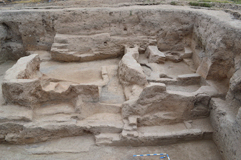
Photo 1. Rooms inside the House I. View from the West
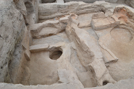
Photo 2. Rooms inside the House I. View from the East
It was found out that the Street 1 of the strata 4 goes deeper (stratum 5-6?), and that the Street 2 of stratum 5 (of 2014) is a room in form of long corridor (Photo 3). It has sufas and tandyr-structures along its walls (see below).
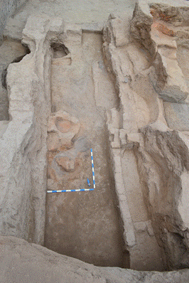
Photo 3. Room 29. View from the South
The research of the Street 1 in both strata (4 and 5 (6?) brought some interesting finds (Photo 4 and 5).
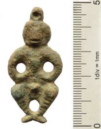
Photo 4. Street 1. Bronze amulet, strata 5/6?
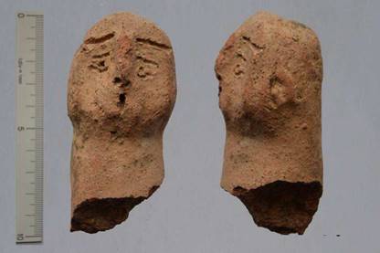
Photo 5. Street 1 Fragment of anthropomorphic sculpture, strata 5/6?
During 2015 19 rubbish pits and were partly or fully excavated. They belong to tree strata. The rubbish pits 2/15, 3/15, 5/15, 6/15, 17/15, as well as following ones, which were found and partly researched before (6/12 and 11/14), belong to the upper stratum 3. Following rubbish pits belong to the next stratum: 1/15, 4/15, 10/15, 16/15, 1-2/13 ?) as well as following ones, which were found and partly researched mostly 2013 (9/13, 12/13, 7/14=10/13, 13/14). Following rubbish pits belong to the lowest stratum 6/15, 7/15, 8/15, 11/15, 12/15, 13/15, 15/15, 18/15, 19/15.
Some rubbish pits of the stratum 3
Rubbish pit 1/15 is located to the East of the rubbish pit 12/13. During forming the rubbish pit 12/13 a part of the rubbish pit 1/15 was destroyed, so the rubbish pit 1/15 is older than the rubbish pit 12/13. The filling is a black clay with ash inclusions. There are some small pieces of mud bricks inside it. Only some small fragments of ceramic (mostly hand made) and some burned animal bones were found in the filling.
Rubbish pit 3/15 is located in the room 16 as well. Its diameter – 70 cm, depth – 50 cm. The surface of the floor of the room 16 covered this pit. Its thickness – ca. 4 cm . In its northern part the wall was found, which is located on the line East-West. The pit as of a regular cylindrical form. The filling is soft, with inclusions of ash, some small fragments of ceramics and animal bones were found in the filling.
Rubbish pit 5/15 is located in the room 17, close to its north-eastern wall. Its diameter – 64 х 70 cm, depth – 47 cm. The filling is hard. Many fragments of ceramics, incl. a piece of burned brick and animal bones were found in the filling (Photo 6).
Photo 6. Rubbish pit 5/15. View from the East
Rubbish pit 8/15 is located in the northern part of Excavation II. Its depth is 1,0 m. The filling is relatively soft. Some pieces of mud bricks and fragments of ceramics were found in the filling.
Photo 7. Room 26. Rubbish pits 12/15, 13/15, 15/15. View from the South

Photo 7. Rubbish pits 5/12, 11/14, 5/15, 7/15
Rooms 16 and 17 belong to the stratum 4 and are located in the southern part of the Excavation II. Room 17 is located to the North of the room 16.
The southern wall of the room 16 is located outside the Excitation II. Its sizes in excavated form: 4,0 (West-East) х 2,45 (North-South) m. All its walls built of mud bricks. Its western wall is significantly destroyed by the rubbish pits 15/14(=11/13) and 13/12, its northern wall by the rubbish pits 4/09, 14/12, 12/13, its eastern wall by the rubbish pits 2/14 and 2/15. The entrance into this room was not found. It can be expected in the wall, which stays outside the Excavation II.
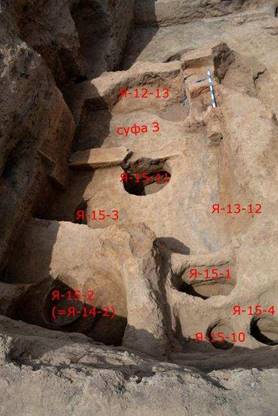
Photo 9. Room 16. View from the East
Along the eastern wall of this room a sufa (?) is located, which in its southern part goes to the border of Excavation II. Its side wall built of three rows of mud bricks. The colour is brown, the mortar is yellowish. The destruction of this wall in form of sinking is documented. The eastern wall of the sufa is almost completely destroyed by the rubbish pit 2/15. Only its remains were documented, their sizes are 60 х 35 cm.
Along its western wall another sufa is located. Its width is 1,15-1,2 m. It was followed to 2,2 m and goes to the border of the Excavation II in the southern part. Is was found out, that the external wall of the sufa was built of three rows of mud bricks as well, so its height is 0,35 m. The colour of bricks is brown. The surfaces of the sufa are covered with yellowish plaster. Its thickness is ca. 1 cm. The filling of the sufa is relatively hard, with inclusions of pieces of mud bricks and guval'a (?). A burned spot in the western part of the sufa was documented. Its diameter is ca. 40 cm, the depth of burning is ca. 2-3 cm.
It is not to exclude, that the northern wall of this room originally had a sufa as well, but this area was extremely destroyed by the rubbish pits 14/12 and 12/13. So it can not be confirmed.
The floor in this room is of a good quality, smooth, covered with plaster. It has a slope from the western sufa to the centre.
The filling of this room is relatively soft, with inclusions of ash. In the filling a series of ceramic vessels in fragments was found: one hand made pot with two handles, two fragments of caps and three fragments of coppers.
The room 17 is located to the North of the room 16 and has a neighbouring wall with it. Its sizes: 3,4 (West-East) х 3,7 (North-South) m. The entrance from the Street I into this room is located probably in the northern wall along the western wall. But it is not surely clear, because this area is strongly destroyed by rubbish pits 11/14 and 17/15. There is a wide sufa along the southern wall. Its width is ca. 1,1-1,15 m. It is significantly destroyed by the rubbish pits as well.
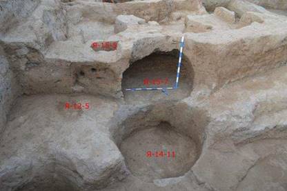
Photo 10. Room 17. Surface of the northern wall. View from the North
A small part of sufa along the western wall is remained. Here the base of small tandyr 3 was found. Its diameter is ca. 50 cm, height of its walls is ca. 3-5 cm. In the filling of tandyr a miniature ceramic vessel was found (Photo 11).
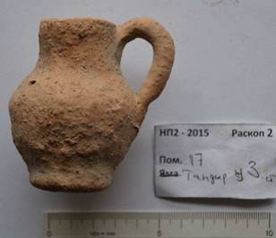
Photo 11. Miniature ceramic vessel from the tandyr 3
The northern wall of this room had probably a sufa as well. A tandyr and a base of a corner oven were located on it. The tandyr 2 is small, its diameter is ca. 4-6 cm, its walls are almost vertical. Their height is 25 cm. The base of this tandyr is built of mud bricks/guval’a. The external surfaces of tandyr were covered with yellowish plaster, its thickness is ca. 1 cm. The bottom of tandyr was formed of fragments of hums. The sizes of tandyr base – 120 х 60 cm.
The northern wall of this room was completely destroyed by the rubbish pit 17/15.
In the northern-western corner of this room the oven 3 was found. It is of rectangular form. Its sizes: 30 х 45 cm. It covered another oven 4, which goes into the western wall. It is of rectangular form as well. Its sizes: 35 х 50 cm. The height of walls of ovens: 15-20 cm. In the near of oven 4 a bronze element of music instrument (?) was found (Photo 12).
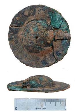
Photo 12. Room 17. Bronze element of a music instrument (?)
The floor in the room 17 has a small slope (3-6°) to the centre as a result of sinking.
On the floor to the East from centre an intensive burning spot (oven 1) is located. In the near of it a destroyed jug with ornaments was found. The filling of this room was clayish, relatively hard with ash inclusions. A big complex of ceramics was found inside it: fragments of jugs, handles, fragment of humča, bowls, small pan, flat caps, dastarhan (Photos 13, 14).
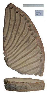
Photo13. Room 17. Fragment of dastarhan
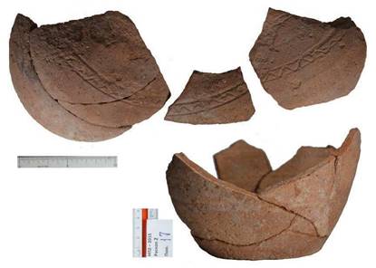
Photo 14. Room 17. Fragment of vessel with ornamentation
Both rooms are located under the floor of rooms 16 and 17, belonging to the stratum 4.
Room 25 is of rectangular form and is located on the line West-East (Photo 15). Its western, northern and partly eastern walls are inside the Excavation II. Its excavated sizes: 2,2 (western wall) х 4,5 (northern wall) х 2,9 (eastern wall + border) х 3,8 (southern border) m. The western wall is built of mud bricks of light clayish colour with grey mortar. It has a sufa. The width of sufa is 1,4 m. Its surface is covered with tick layer of plaster (5-8 cm) of yellow colour. Its base is correlated with level of the wall. The wall of stratum 5 built of mud bricks, stays on another cut wall of stratum 6, which built of pachsa. The last one is of yellowish colour. Between both walls there is a thin ash layer (2-3 cm) of black-grey colour.
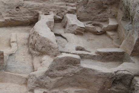
Photo 15. Room 25. View from the West
Such stratigraphical situation allows to suppose, that that area (before the wall of stratum 5 was built) stood without any building structures for a while. During the building the room 25 upper ash layers were cut vertically and horizontally and according to this the sufa was made, the room itself went somewhat deeper.
The northern wall was built on the same way. It was extremely destroyed, as well as its base, which was built of pachsa. Based on the floor of the room this wall originally had a sufa as well. Its width – 50-70 cm.
A sufa went along the eastern wall of that room. Its width – 55-75 cm, height – 30-35 cm. It fully corresponds with sufa of stratum 4. Inside the sufa two tandyrs were located. After the first/original tandyr lost its function, another one was built here, but now somewhat closer to the external wall of sufa (Photo 16).
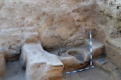
Photo 16. Room 25. Sufa with tandyrs. View from the East
The sufa in the north-eastern corner of this room is somewhat higher (45-50 cm). Its width is 130 (North-South) х 120 (West-East) cm. The wall of this sufa is destructed because of sinking the ground below it (filling of room of stratum 6). The whole floor has a slope to the centre. The entrance to this room went possibly from the room 28 in the North. There is another sufa along the southern wall here. Its height is 10-15 cm.
There are only some finds from this room, including some of them, coming from the filling of the sufas (Photo 17).
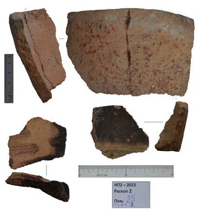
Photo 17. Room 25. Filling of the sufa 3
Room 28 is located to the North of room 25, stratigraphically under the floor of room 17. It is of quadratic form, its sizes: 4,65 (northern) х 4,25 (eastern) х 4,35 (southern) х 4,2 (western) m (Photo 18).
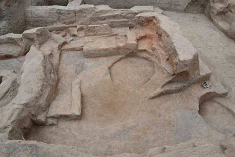
Photo 18. Room 28. View from the West
The height of the northern wall is 70 cm (8 rows of mud bricks). Its width is ca 60 cm. The mud bricks are of brown colour with grey mortar. The building technique of this wall is similar with the western wall of the room 25. The eastern wall, which is located on the border of Excavation II, is built of mud bricks of brown colour with grey mortar (7 rows of mud bricks). The southern wall has a sufa. Its width is 80 cm. In the southern wall along the eastern one there is an entrance. Its width is 90 cm (Photo 18). The floor has a slope to the centre.
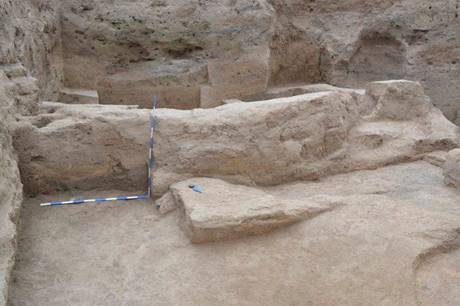
Photo 18. Room 18. Southern wall with entrance to the room 25.
View from the North
Finds: fragment of humča, some fragments of ceramic coppers and caps.
Room 20 (Stratum 4)The works were concentrated here on the research of the wall between rooms 20 and 24. It was the wall, which was found 2014, and it is built of pachsa. Along this was there was a sufa. The all of the sufa was built of two rows of mud bricks (47-48 cm). The level of this sufa corresponds with level of the wall. So we see here the same technique, that we documented based on the research of the western wall of the room 25 of stratum 5 – the floor of the room was made deeper, than the neighbouring surface. The width of the sufa is 1,55 m, height is 2 cm.
In the filling of this room some fragments of ceramic vessels were found.
That are fragments of humčas, tagoras and handles of jugs (Photo 19).
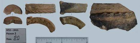
Photo 19. Fragments of ceramic vessels from the filling of the room 20
South-western part of Excavation II: Rooms 26, 27, 29 (strata 5/6)
Room 27 is located under the floor of the room 20. Only one part of this room was excavated because its northern and eastern parts go to the border of the Excavation II and the southern and western parts are fully outside it. Its excavated sizes: 1,65 (eastern wall) х 1,8 (northern wall) х 1,34 (border West) х 2,0 (border South) m. The eastern and northern walls are built of pachsa. Their thickness is 0,9 and 1,05 m measured in their bottom part. The filling of this room is clayish, very hard.
Among the finds from this room are to mention some fragments of copper with small vertical handle, fragment of cap with decorated surface and some interesting handles of jugs.
Room 26 is located to the North of the room 27 and has a neighbouring wall with it. The western part of this room is located outside the Excavation II. Its sizes: 0,95 (northern wall) х 3,2 (eastern wall) х 1,65 (southern wall) х 3,2 (border West) m. The room was excavated only partly. The walls of the room are built of pachsa, the clay is of yellowish colour with inclusions of pieces of mud bricks. The filling is very hard, clayish (Photo 20).
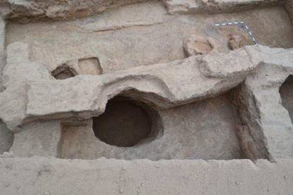
Photo 20. Room 26 View from the West
A relatively big complex of ceramics was found in the filling of this room. Among them some fragments of unfired čirags (Photo 21), of small bowl, of dastarhan, base of burner, a series of handles of coppers and caps without decoration.
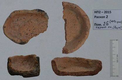
Photo 21. Fragments of unfired čirags
Room 29 is located to the East of rooms 26 and 27 and has a neighbouring long wall them (Photo 22).
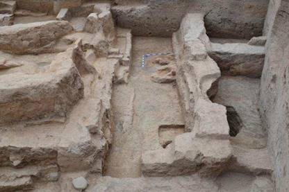
Photo 22. Room 29. View from the North
Its southern part is outside the Excavation II: Its sizes 6,8 (eastern wall) х 1,55 (northern wall) х 6,4 (western wall) х 2,15 (southern border) m. Stratigraphicly it is located under the level of Street 2. There are no passages in the western and eastern directions. It is to suppose that it was an area between two Houses, which was used for housewifely needs.
There are two building levels here. The room of the upper level has a sufa 1 in the south-eastern part and of the lower level – sufa 2 in the north-eastern part as well as a tandyr belonging to the western wall of the room. The width of sufa 1 – 50-55 cm. Its documented length – 1,6 m being destroyed by the rubbish pit in its southern part. Its height – 40 cm. The external wall of the sufa is built of mud bricks of light-grey colour. In the near of sufa remains of a wooden board were documented (Photo 23).
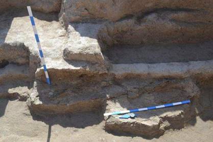
Photo 23. Room 29. Remains of a wooden board on the near of the sufa
Its length – 1,3 m. The sufa 2 belongs to the lower building level (35-40 cm lower than sufa 1). Its external wall is built of mud bricks as well. Its width – 60 cm. Its documented length – ca. 2,0 m. The height of walls of tandyr – 25-30 cm. Its diameter (bottom) – 35-40 cm. The base was built of mud bricks of light clay. In the near of tandyr a lot of burned pieces of mud bricks was found (point 1 and 2).
The filling of this room is hard. A big series of ceramic vessels was found in the filling inside this room (Photo 24, 25).
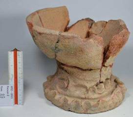
Photo 24. Room 29. Ceramic vessel from the filling
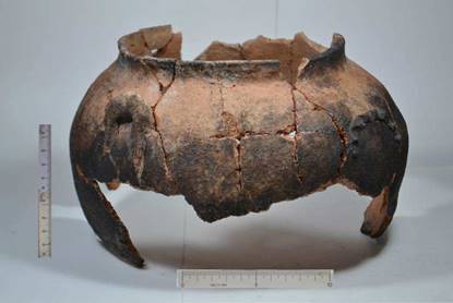
Photo 25. Room 29. Ceramic copper from the filling
In the filling of tandyr of this room a ceramic vessel was found (Photo 26).
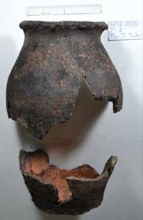
Photo 26. Room 29. Ceramic vessel from the tandyr
As result of archaeological works of 2015 the research of the strata 4 and 5 was finished. At least two following strata were documented: 6 (structures with pachsa-walls) and 7 (structures with mud bricks walls).
To stratum 4 belong rooms 16 and 17, which are located inside the structure marked in 2014 as House I. Small structures in this part of Excavation II (rooms 18 and 19 of 2014) can be now interpreted as sufas.
The House I corresponds with strata 5 and stays on the shuted structure, belonging to the strata 6. The level of walls of House I of stratum 5 correlates with level of sufas, and the floor’s level is located somewhat lower. The House I continues to exist also in the stratum 4 in the same form but with new configuration of sufas.
Rooms 20 and 21 belong to the stratum 4 in the western part of Excavation II: System of their walls correlates with those ones of the House I, but there is a difference in their construction: in one case they are built of mud bricks, in the other one – of pachsa.
Under the level of rooms 20 and 21 two following rooms were found: 26 and 27, which form House III. Their walls built of pachsa. So we now know that House I and House II belong the different strata. Between these ones there was a free area. Here there was a room 29, which belongs to the stratum 5.
Street 1 continues to exist also in the strata 5, but somewhat narrow.
Eight coins were found (see Attachment) in 2015. Two of them are Chinese coins Kai Yuan Tun Bao, other ones – so called Türgesh coins (Soghdian coins of Semirečye). Two of last ones were found in the stratum 5, on the street 1. Other ones come from the rooms and Street 1 of the stratum 4. All these data allow dating the excavated strata to time not earlier than 8 century, and in correlation with ceramic – to the end of 8-9 century.
№ |
Location |
D |
Weight |
Thickness |
Type |
|
1 |
Room 16, near the southern border of Excavation II, grey layer, stratum 4 |
24,95 |
5,12 |
2,15 |
So called |
|
2 |
Room 16, southern- western corner, grey layer, stratum 4 |
24,25 |
1,85 |
1,45 |
Kai Yuan Tun Bao |
Extremely oxidized |
3 |
Room 17, near the western wall, grey layer, stratum 4 |
24,0 |
- |
1,2 |
So called |
Extremely oxidized |
4 |
Rubbish pit 8/15 |
- |
- |
- |
So called |
Extremely oxidized |
5 |
Street 1, northern- western corner, grey layer, stratum 4 |
24,6 |
2,9 |
1,85 |
Kai Yuan Tun Bao |
Considerably oxidized |
6 |
Street 1, grey layer 3 |
21,1 |
1,46 |
2,0 |
So called |
Fully oxidized |
7 |
Street 1, northern- western corner, stratum 5 |
25,55 |
5,87 |
2,55 |
So called |
|
8 |
Street 1, northern- western corner, stratum 5 |
24,4 |
3,9 |
1,8 |
So called |
|
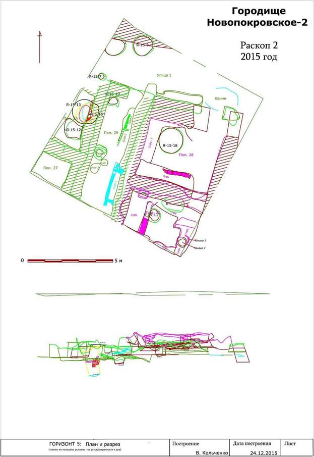
Plan 1. Stratum 5
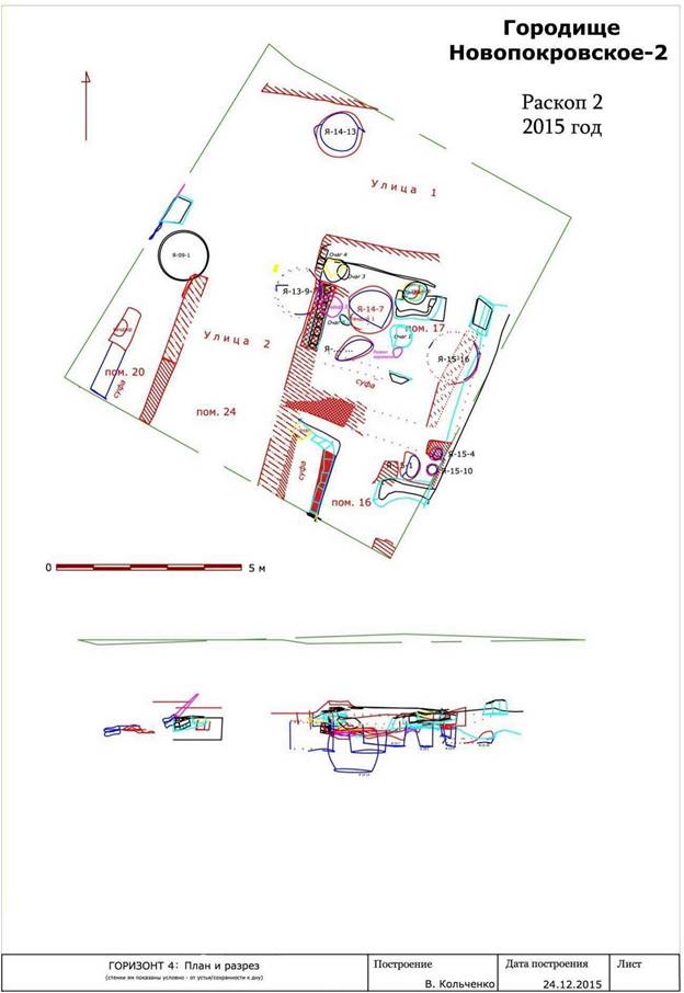
Plan 2. Stratum 4
Report
on the excavations on the site Novopokrovskoe II in 2016
(download here)
V. Kol'chenko, F. Rott
In 2016 the Novopokrovskiy archeological group of the Institute of History and Heritage of the National Academy of Sciences, with the support of the Society for the Exploration of EurAsia, Switzerland, continued the excavations of the medieval site Novopokrovskoe II. The work was done in Excavation I (small additional studies) and Excavation II.
Excavation I
In Excavation I we continued researching square 4 (5 x 5 m) in the north-west corner. The upper strata were studied here. In the uppermost layer the walls of the room 27 were identified, under it 2 smaller rooms 29 and 30 were opened. They were fully investigated and documented. Their walls were removed; and under them room 31 was found. It occupies almost fully the square 4 (Pic. 1).

Pic 1. Square 4. Rooms 29, 30. View from the south-east.
The
square 3 to the south was also researched: here the earlier layers were studied
(Horizons A3-B1). Under the walls of the previously excavated room 22, room 28
was identified (Pic. 2). Its western mud brick wall goes in the border of the
square 3.

Pic 2. Room 28. View from the south.
A series of seven rubbish pits was found 2016. Most of them contain animal bones and ceramic finds (Pic. 3).

Pic.
3. Ceramic finds from rubbish pit 7/2016
We researched layers of
square 3: the layers under the room 22 of Horizon A which belong to the Karachanid
time, and the filling of the room 28, which is not fully excavated. The layers
of square 4 (correlated with data collected before) can be dated to the end of
XI-XII centuries.
Excavation II
In excavation II the layers of the Horizon B were further studied. The constructions of room 25, which was excavated in 2015, were removed. And under them two new rooms 30 and 35 were opened. To the north of them the structures of room 28 (excavated 2015 as well) were studied. Under it the room 31 was documented. Three floor levels with associated sufas and other constructions were found here. Along the western border of the Excavation II under the room 26 and 27 (both of 2015) new rooms 33 and 34 were opened (Pic. 4).

Pic.
4 Excavation II. View from the west.
In the area to the west of the House I, which was marked as a Street 2, incl. room 29/2015, the lower layer was researched. Here the new room 32 was documented.
House I
House I is located in the south-eastern part of Excavation II. To the west of it there are street 2 (opened 2014) as well as rooms 29 (2015) and 32 (2016), to the north there is street 1. House I consists of two rooms 25 and 28. 2016 the excavations were continued here. The following rooms were found after removing the floors of the mentioned rooms: 30 and 35 and 31 to the north of them. In the last one three levels of sufas were documented. They go along the southern wall of the room. On the floor of room 25, closely to the eastern wall, there is a tandyr. Its sizes: 54-58 cm. Its height is 23 cm. Its walls are intensively burned. Inside the tandyr three fragments of a ceramic П-formed oven-stand were found. The room under the floor of room 25 was marked as room 30. It occupies practically the same area as a room 25.
In this room there were sufas along the northern, western and eastern walls. Their height is four mud bricks or 40-45 cm. The southern wall is located outside Excavation II. Anyway, no remains of the sufa along this wall were documented. The mud bricks of the eastern sufa are brown, their remained sizes here are following: 25 х 9 cm, 26 х 9,5 cm, 15 х 10 cm, 18 х 8 cm. The upper layer of the western sufa is grey, sizes: 20 х 9 cm, und lower ones are brown with sizes: 16 х 8 cm, 26 х 9 cm and 21 х 10 cm. The width of the eastern sufa is 80 cm, of the western sufa 97 cm.
The sufa 3 is made of mud bricks of grey colour. Their remained sizes: 21 х 7 cm, 23 х 8 cm, 23 х 6 cm. The wall of sufa has a slope inwards because of sag in the centre of the room. The eastern wall of the room is covered with a plaster of a good quality of yellow colour.
Between those sufas, closely to the western sufa, a floor oven was documented (Pic. 5). Its base is of one mud brick height, it is covered with a plaster. All surfaces of the base are covered with two layers of a plaster. The plaster is clayish, of yellow colour, the thickness of each layer is 2-3 cm.

Pic. 5. Room 30.
Section of the floor oven and of the western sufa. View from the north.
The area between both sufas was filled with mud bricks and afterwards the floor was made. The mud bricks are of yellow colour. Their remained sizes: 20 х 10 cm, 28 х 10 cm, 24 х 9 cm, 28 х 8 cm.

Pic. 6. Room 30.
View from the south.
Under the level of room 30 there is another room 35 (Pic. 7). The southern and eastern walls of this room are outside Excavation II. The filling is soft, in the under-floor layer a lot of organic remains in form of green lenses.

Pic. 7. Room 35.
View from the south.
In the northern wall there is a passage into room 31 (Pic. 8).

Pic. 8. Room 35. The
passage to room 31. View from the west.
Along the western, eastern and northern walls there are sufas. All of them as well as a floor are covered with a plaster. 2016 the sufas were not dismantled, so their construction remained not clear.
In the north-eastern corner of the room the mud brick block was documented. Its sizes: 137 х 60-80 cm. The mud bricks inside the block lie obliquely (Pic. 9).

Pic. 9. Room 35. Mud brick block in the south-eastern corner
of the room. View from the South

Pic. 10. Room 35.
Ceramic oven stand.
The northern wall of the room 35 consists of mud bricks of following sizes: 9-9,5-10 cm, ? х 20 х 10 cm, 37 х 20 х 10 cm, 47 х 24 х 9 cm. Some of mud bricks have however another size: ? х 22 х 6,5 cm.
The area under the floor of the room 28 is marked as a room 31 (Pic. 11).

Pic. 11. Room 31.
View from the east.
Beginning from the western part of the entrance from the south from the rooms 30/35, which goes along the eastern wall, there are remains of a sufa. The height of its walls is 2-3-layers of the mud bricks of light-brown colour. The sizes of the mud bricks: 24 х 23,5 х 8,5-9 cm and 23 х 23 х 9,5 cm in the upper layer and 40 х 22 х 8,5-9 cm and 20 х 22 х 8,5 cm in the lower layer. The thickness of the mortar is ca. 1 cm. The external wall is covered with one layer of plaster (0,2-0,3 cm). The bricks of the sufa are put to the southern wall not closely but lie on the small goaf (up to 7 cm). Under the lower bricks there is a thin layer of ash (sufa 3). The sufa 2 covered the sufa 3. It is made of mud bricks of brown colour put on thin mortar of the dark colour (Pic. 12).

Pic. 12. Room 31.
View from the north.
Street 1
In 2016 the street 1 was researched. Two layers of stones were documented here (Pic. 13, 14), which correspond with two building periods/renovations of the area here. The upper layer consists of relatively big stones (its width is 0,95-1,2 m); the lower one consists of shingles. The surfaces of the street themselves are done of clay, immediately along the wall of the House I almost no stones were documented. So there is a strip of clay here, which is free of stones.
In the surfaces of both levels of the street ceramic pieces and animal bones are incorporated.

Pic.
13. Street 1. View from the west.

Pic.
14. Street 1. Two layers of stones.
The traces of horizontal (10-12 cm) and vertical (6-8 cm) wooden poles were documented. We suppose that due to these poles the street was enhanced and repaired (Pic. 15). Unfortunately the system of those poles is remained too poor, which does not allow any reconstructions.

Pic. 15. The eastern part of the street. The traces of horizontal wooden poles.
View from the north-west.
Apart from ceramic pieces and animal bones,
the fragment of a bronze bracelet was found on
the surface of the steet (Pic. 16). Only one third of
it is remained. It is round in shape. It does not allow any conclusions, because
the typology of such bracelets does not exist
for the region and it is a single find.

Pic. 16. Street 1. The fragment
of a bronze bracelet.
Six rubbish pits were found here. They contain mostly ceramic fragments (Pic. 17-18) and animal bones.

Pic. 17. Street 1. Fragment of ceramic vessel.

Pic. 18. Street 1. Fragments of miniature ceramic vessels which
probably served to store oils or spices; several of them were found in kitchen
environments.
The rubbish pit 6/2016, as we could documented, dropped from the level of the sufa 2. It is round, has a porous filling, including organic remains and ash. In the filling there are animal bones, some ceramic fragments, mostly hand made as well as mud bricks of brown colour.
At the Excavation II the layer which was researched in 2016 belongs, according to the relative stratigraphy, to the IX century.
The finds of Türgesh coins (and of so called Türgesh type) on the surface of the street (Pic. 19) allow to date it not earlier than the VIII century.

Pic. 19. Excavation II. Coins.
Conclusion
The archaeological researches done in 2016 provided us with new data regarding to the stratigraphy and planigraphy and brought new finds, including some ceramic vessels which were so far unknown in the Chu Valley. An important point is the study of the structure of the street, which is also unusual for the mentioned region. Such profound and complicated structured street was rather unexpected for such a small settlement. The complete analysis of the street and the layers under it and under the House I will be done 2017.
16th March, 2017
Archaeological Excavation at Novopokrovskoe II 2017
V. Kolchenko, Ph. Rott The archaeological works of 2017 were concentrated on Excavations II, III, IIIa (Figs. 1-2)
.
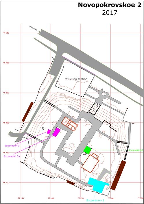
Fig. 1. Plan of all Excavations
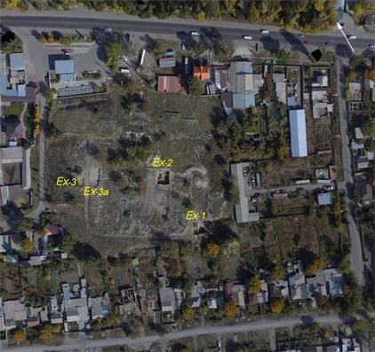
Fig. 2. Plan of all Excavations. View from a drone
Excavation II
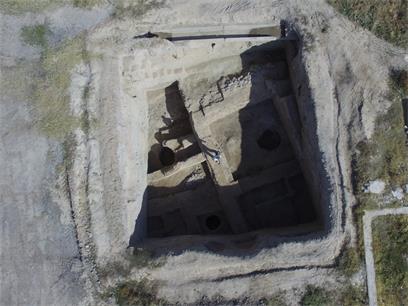
Fig. 3. Excavation II. View from a drone
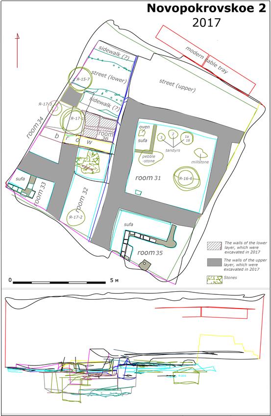
Fig. 4. Excavation II. Plan
In Excavation II the walls of House I were removed up to the level of street I (along its northern border). The walls of all rooms were fully researched. Already in 2016 it was noticed that the walls of rooms 33 and 34 have the following structure: they consist of a massive pachsa centre and are lined on both sides with mud bricks.
Room 35 is located in the southern part of House I (Fig. 5).
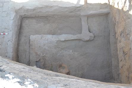
Fig. 5. Room 35. View from the south
The walls of room 35 have the same structure: it is very well visible especially at the west wall of this room (Fig. 6).
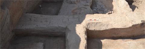
Fig. 6. Room 35. View from the east. The structure of the northern wall
Inside the wall between rooms 31 and 35, in its lower part, a ceramic oven stand and a turgesh coin were found (Fig. 7).
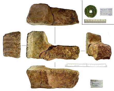
Fig. 7. Room 35. Ceramic oven stand and turgesh coin
This level corresponds with a level of floors between rooms 30 and 35, which allows us to date the construction of those rooms to a period not earlier than the 8th century.
In room 35 a series of sufas was found. All of them are covered with clay plaster.
The excavation of room 31 was completed. It is located in the northern part of House I. A sufa was found in the western corner of this room. Its sizes: 2,8 х 1,0 m. The walls of the sufa are built of half-sized mud bricks. A series of ovens and tandyrs was documented here. Their levels cover each other (Fig. 8).
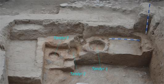
Fig. 8. Excavation II. Room 31. A series of ovens and tandyrs along the northern wall
The upper tandyr (1 a) is 0,7 m in diameter. It was documented that after destroying the new smaller one (1 b) it was integrated inside it. Its diameter is 0,55 m (Fig. 9).
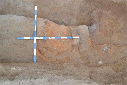
Fig. 9. Excavation II. Room 31. Tandyrs1 and 1 a along the northern wall
The lowest tandyr 2 is located between tandyrs 1 and 3 (740,85 m). As base of the tandyr 3 the upper part of a big hum was used (Fig. 10).
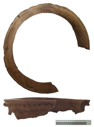
Fig. 10. ExcavationII,Room 31. Upper part of a hum as base of tandyr III
From the level of the sufa comes a fragment of ceramic copper (Fig. 11).
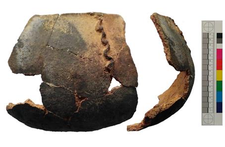
Fig. 11. Excavation II, Room 31. Level of the sufa: A fragment of ceramic copper
Under the level of the sufa there is an ashy stratum, which continues under the level of the walls of this room, with other words: the walls were built on this ashy stratum.
In the western part of Excavation II the eastern wall of room 34 was researched and removed. It originally stood on the area covered with shingle. The size of that area is 1,0 х 1,4 m. So the level of this stratum corresponds with the level of street I.
In room 33 in the south-western corner of Excavation II, which was found in 2016, the sufa along its northern wall was researched. In 2016 that was impossible due to damages to identify a corridor from this room to the north. It was documented that the eastern wall of this room up to the south-eastern corner is uniform, and it does not continue to room 34 (which is located to the north of room 33). The northern wall of this room has an interruption, which can be interpreted as a corridor from this room. This corridor originally had a doorstep. Some remaining bricks indicate this (Fig. 12, 13).
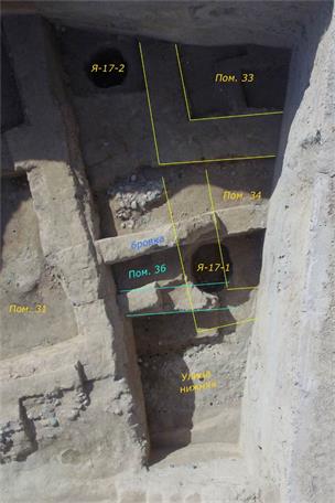
Fig. 12. Rooms 33 and 34. View from above
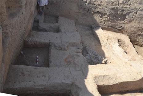
Fig. 13. Rooms 36 and 33/32
Room 34 is located to the north of room 33 (Fig. 12). In season 2017 its eastern and northern walls (which were inside Excavation II) were completely excavated. They stand on the thick ashy stratum and do not go deeper than its level.
Room 32 (Fig. 12) is located to the east of rooms 33 and 34. Under the floor of this room some ceramic fragments were found. This level belongs to the filling of the upper room 36 (Fig. 14). This room has been investigated only partly. The northern wall of the new room 36 was documented in the northern part of rooms 32 and 34. Its northern face corresponds with the southern face of the northern wall of these rooms (see Fig. 12). In the central part of room 36 the area covered with shingles was documented. Its function remains unclear (Fig. 12).
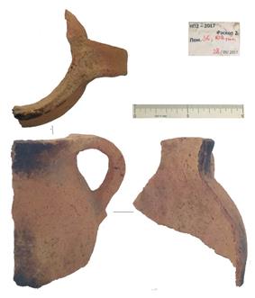
Fig. 14. Excavation II. Room 36. Fragment of ceramic jug.
Under this level inside room 31 the rubbish pit 6/2016 was completely researched. Some ceramic fragments come from this pit (Fig. 15, 16).
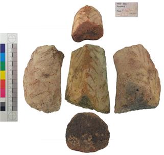
Fig. 15. Excavation II. Room 31. Rubbish pit 6/2016.
Fragments of ceramic oven stand
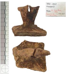
Fig. 16. Excavation II. Room 31. Rubbish pit 6/2016. Fragments of ceramic lid
The research of the strata of the area between houses I and II (room 32) near the southern border of Excavation II led to the discovery of the rubbish pit 1/2017 (Fig. 12). A small collection of ceramic fragments was found in its filling.
In the area in the northern-western part of Excavation II the other level of street I (level III) was found. The last one is located ca. 1,6-1,7 m deeper than level I. Its width is ca. 1,5 m. The street itself has pavements on both sides. The surface of the street and partly of the pavements of this period was also covered with shingle (Fig. 17).
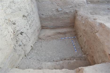
Fig. 17. Excavation II. III level of the street
In 2017 a series of artefacts and coins was found (Fig. 18-20).
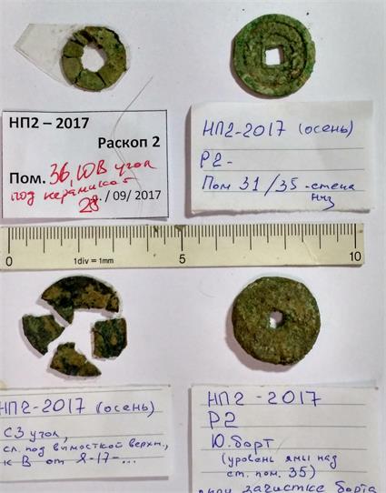
Fig. 18. Excavation II. Turgesh coins of different diameters
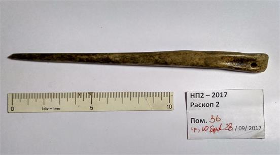
Fig. 19. Room 36. Excavation II. Bone awl/needle
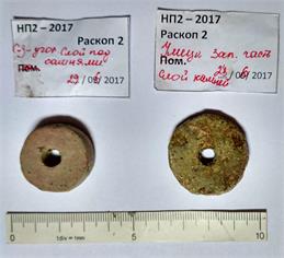
Fig. 20. Room 36. Excavation II. Street. Level II. Spindle whorls.
Excavations III and IIIa
The purpose of Excavation III was trying to find remains of Buddhist structures in the settlement. The materials yielded by Excavations I and II couldn’t answer “the Buddhist hypothesis” (based on the complex of Buddhist artefacts found during the building of the House of Culture ). They are all of profane rather than cultic/religious character, while some artefacts like a terracotta image in “Buddhist style” or a musical instrument with a Buddhist background, which were found during Excavation II, support the idea that the excavated living structures could have belonged to the local Buddhist community. So we decided to choose one more area to check the “the Buddhist hypothesis”.
In the western part of the settlement, where a small hill was documented in 1959 by P. N. Kojemyako (he gives the size of the hill as 30 m in diameter, its height was 2 m from the surface of the whole settlement) , the upper layers (their depth is up to 60-80 cm), including modern rubbish and remains of buildings, were removed (using a bulldozer) up to the upper remaining in situ layers (Fig. 21).
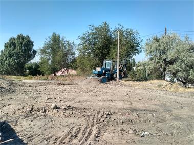
Fig. 21. Excavations III and IIIa.
A bulldozer removes upper concrete, rubbish and remains of modern buildings
That area was marked as Excavation III (western) and III a (eastern). They have different sizes and are divided by the concrete road (Fig. 22).
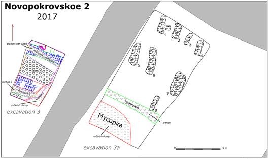
Fig. 22. Plan of Excavation III and III a. 1-8 – oval structures, possible graves
The size of Excavation III is 6,7 х 4 m. Here two parallel massive walls, which are built of mud bricks, are documented. They are oriented north-south. The space between them is filled with shingle. In the filling there are pieces of mud bricks. Its width is 2,6 m. The documented length of the northern wall is 4 m, its thickness is 0,85-90 cm in the eastern part and 1,2 m in the western part (here it is destroyed by the modern trench). It is built of mud bricks of light-brown colour. The mortar (thickness is 1 cm) is of dark-grey colour. The size of the remaining bricks: 37-41 х 20-22 х 8-9 cm.
To the west of this wall there is an area with ash – most possibly remains of a destroyed tandyr block, consisting of a reservoir for ash and the tandyr itself. The block was originally covered with clay plaster. Its thickness is 1 cm.
The length of the southern wall is 2,6 - 3,1 m, in its eastern part it is destroyed by the modern rubbish trench. The wall is built of dark mud bricks in order of 2,5 bricks. Its thickness is 1,2 - 1,25 m. The bricks in the wall are of the following sizes: 36 х 20; 39 х 23; 41 х 24; 46 х 23 cm, their thickness is 8-9 cm. The thickness of the mortar is very variable: 1 - 5 cm (Fig. 23, 24, 25).
Some deep modern canals were documented here as well.
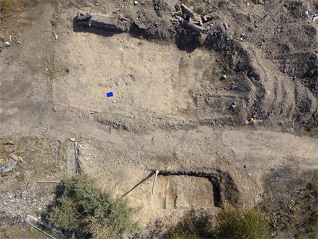
Fig. 23. Excavations III and IIIa. View from a drone
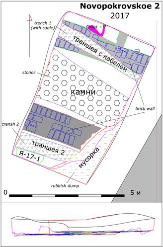
Fig. 24. Excavation III
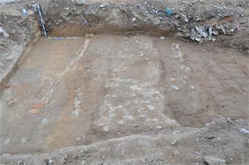
Fig. 25. Excavation III. Two massive walls and shingle filling between them
Excavation IIIa is located to the east of the concrete road and is bigger than Excavation III (its sizes: 15 х 7,5 m or 102,5 m²). Here a series of 8 oval structures is documented. They are oriented north-south. All of them are filled with stones. They are arranged in relatively regular rows. The sizes of these oval structures are: 1 - 2,14 х 0,55 m, 2 - 1,78 х 0,8 m, 3 - 1,48 х 0,5 m, 4 - 1,7 х 0,65 m, 5 - 2,6 х 0,8 m, 6 - 3 х 0,95 m, 7 - 2,8 х 1,35 m, 8 - 1,9 х 0,5 m. (Fig. 26, 27).
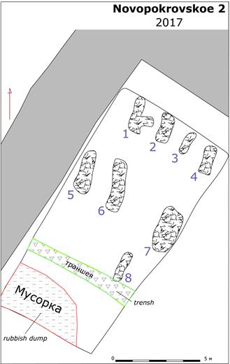
Fig. 26. Excavation III a. Oval structures filled with stones
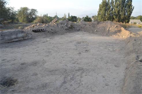
Fig. 27. Excavation III a. Oval structures filled with stones
The structures themselves have not been excavated, but we believe that they are fillings/remains of graves. According to old local people, there was a Muslim cemetery from c. 19th -20th century at that place before the construction of the House of Culture in the mid-1950s.
Possibly we deal here with remains of two houses, divided by a street. Stratigrafically they belong to the Karachanid period. No structures or artefacts that can be correlated with Buddhism were found here.
In 2018, the last excavation season, we plan to reach the topsoil of excavation II, concentrating on the research of structures of the earliest building period of the settlement. Then the excavation will be closed and a concluding report prepared.
Novopokrovka II, 2018
Due to unforeseen issues, the final campaign has been postponed to 2019.
| copyright by Gesellschaft zur Erforschung
EurAsiens | E-mail
| Home
| ![]()