FIELD REPORT
ON THE
ARCHAEOLOGICAL EXCAVATIONS
AT ILIBALYK SITE
(MEDIEVAL CHRISTIAN NECROPOLIS),
KAZAKHSTAN IN 2023
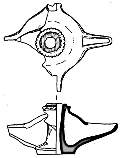
FOUR-NOZZLE LAMP (CHIRAG)
Almaty 2024
LIST OF EXCAVATORS
Introduction
Excavations at Usharal-Ilibalyk in the Republic of Kazakhstan has now completed their eight season. This past summer, July 9-30, 2023, the international excavation team continued archaeological investigations within Area C of Field IV, a Christian cemetery and funerary chapel at the Ilibalyk site, a 5000 m 2 medieval city that existed between the 10th through 15th centuries.
This project is under the direction of Dr. Dmitry Voyakin (Archaeological Expertise, LLC and International Institute for Central Asian Studies); with field direction under Mikhail Gurulev (Archaeological Expertise); and financial sponsorship by the Society for the Exploration of Eurasia (Dr. Christoph Baumer, President) in joint-participation by Lipscomb University’s Lanier Institute for Archaeology (Nashville, TN, USA, Dr. Stephen Ortiz, Dr. Thomas Davis). Additional sponsorship has also come from an anonymous group of private donors both in the United States and the Republic of Korea. In addition, both professional archaeologists, archaeology students, and local and international volunteers from 12 different countries have participated in this project over the years exceeding 200 participants and laborers. Of special note is the team of workers from the village of Usharal (Panfilov district) itself, who have provided excellent labor consistently every year together with the support of the local administration (with special thanks to the village akim (mayor), Tanatar Zhangaziev) and townspeople who annually extend their hospitality.
This excavation’s methodology, processes, and results have been carefully documented at the conclusion of each season. In addition, as the bibliography indicates, several recent publications have provided a clear record of both the results and interpretations rendered based on both the archaeological and historical context. The annual field reports can be found at https://www.exploration-eurasia.com/inhalt_english/frameset_projekt_aC.html.
The Ilibalyk investigations have provided groundbreaking information concerning the presence of medieval Christianity, specifically Church of the East (Nestorian), as it existed between the 12th-14th centuries in the Zhetisu (Semirechye) region on the territory of today’s Kazakhstan. The Christians at Ilibalyk were part of a larger Christian community throughout Zhetisu that extended the length of the so-called Silk Road of Central Asia during the Mongol period, and most specifically under the domain of the Chagatay khanate between the mid-13th through early 14th centuries. To date, 110 graves have been excavated in the Christian cemetery (estimated 60 x 70 m) located in the northern section of the medieval city. In addition, with the discovery of a funerary chapel in 2020, this structure was studied more thoroughly this season with the most recent discovery of either a northern martyrium wing to the chapel or a stand-along mausoleum which contains at least one grave. This tomb contains a person who is potentially a founder of the Christian community and whose burial indicates he was highly revered by the Christian inhabitants of Ililbalyk, with possibly two more graves identified within this structure.
As the following report will explain, more clarity has also been provided regarding a section of the cemetery that is best interpreted as containing burials with Turko-Mongolian nomads based on the interment methods, specifically grave goods. This is the same section of the previously discovered high-status female (L-290) buried with a boqtag headdress (an elite status symbol) whose remains were subsequently examined in a controlled laboratory setting. Her burial not only included the boqtag, but other items placed around the body, such as a dagger, a small jewelry box, and scissors. This season’s excavations revealed another female in an elaborately constructed wooden enclosure who also had a pair of scissors placed to the right (south) of her head; as well as a young “warrior” who was discovered with evidence of weapons placed in this tomb at the time of burial. Thus, these findings may be the first archaeological evidence for nomadic Christians who were known to exist in the region between the 11th-14th centuries.
Such findings, as detailed below, clearly demonstrate a complex community of Christians, with an organized clergy, burial rituals based on the Christian rite, structures dedicated to the declaration of the Christian faith during those funerary rites, and accompanying markers of those graves to perpetuate the memories of the dead. This season’s excavations also extended the border of the cemetery to the east, which is leading to the team’s ability to discern the exact boundaries of the cemetery. The combination of both osteological and cultural material investigations continues to yield a growing abundance of specific information that will aid scholars, historians and archaeologists in the study of Central Asian Christianity and late medieval culture far into the future.
Research Questions and Objectives
The excavation team entered the 2023 season with the following questions:
What is the relationship and function of the section between funerary chapel and the cemetery?
Do graves continue to the east and south of Unit 15, the easternmost unit of the cemetery in Area C, and is this section of the cemetery indicate a distinct sub-culture within the cemetery in comparison to other graves investigated so far?
Are more graves present in Area B (east of Area C and D) which can further help the teams understanding of the cemetery’s boundaries?
Based on the discovery of water mill stones in 2022 on the stream to the east (Karasu), can more be discerned there with the use of LiDAR drone technology?
Can LiDAR scanning help yield more information concerning the overall Ilibalyk site?
Based on these research questions, an excavation plan was adopted as follows:
Further excavations on the previously revealed graves of excavation Unit 15 will be conducted with special focus on those graves that could not be examined because of the block extraction of L-290 conducted in 2022.
Excavation units will be dug to the east and south of Unit 15 to determine if graves continue in those directions.
Excavations north and east of the funerary chapel will be conducted to determine if any other structures or graves are present in those locations. There will also be an attempt to discern the medieval occupational surface in and around the chapel.
Due to the purchase of a new LiDAR drone, scans will be conducted across the entirety of the Ilibalyk site to provide an updated geodesic survey as well as potentially locate possible structures or features that may require further investigation via excavation.
Excavation Methodology and Equipment Utilized
Because previous methodology and equipment has been detailed in previous reports, the reader is encouraged to consult those reports which provide descriptions and specification on the use of a theodolite total station for GIS, photogrammetry, and basic elevation. Excavation techniques involved the use of earth moving equipment for the removal of initial non-diagnostic agricultural topsoil, shovels, and hand tools such as trowels and even dental tools for more delicate work within graves. The osteological field procedures are discussed in the Field Forensic section. All the soil from graves was 100% sifted to insure the discovery and retrieval of all cultural material.
All activities were photographed and described using written documentation. The following report provides unit and loci descriptions explaining the excavation processes, findings, and interpretations. Excavation baulk profiles were drawn and described. Identified features were provided loci numbers and elevations taken for these features and/or for any special cultural finds. All pottery and other cultural material was carefully cleaned according to procedure with key examples drawn and described below. All the finds were recorded into the overall database, which will soon be made public via an online application.
Special care and documentation were provided to the human remains according to set procedures of previous digs. The remains were packed to carefully preserve the remains which are later examined in laboratory conditions. While field observations of the remains are taken, final conclusions regarding age, sex determination, and possible pathology are made in that setting can are official documented in the lab and will be provided in a future and final report.
Because the LiDAR scanning drone was utilized for the first time, a more detailed report concerning its usage and initial findings are provided below.
LiDAR Survey Report
Introduction
The 2023 expedition utilized a drone-mounted LiDAR solution to generate a dense three-dimensional (3D) point cloud model representing approximately 4 sq km of the immediate excavation site and surrounding context. The point cloud was then analyzed to gain further understanding of ground surface characteristics at and around the excavation site and to assist decisions regarding potential new dig locations. It was hypothesized that analysis of a high-resolution digital reconstruction of the ground plane might exhibit anomalies in the ground surface that could be indications of human-made structures or artifacts beneath. The LiDAR scans were also used to confirm and supplement measurements taken on the ground of various excavation features.
General Description
LiDAR is an acronym that stands for Light Detection and Ranging. The technology has been around for several decades, but in recent years has seen new applications developed in coincidence with the growth of the remotely controlled aerial drone industry. These applications range from surveying and mapping to environmental management and agriculture.
A LiDAR unit utilizes a reflected laser pulse to measure the distance to some observed subject. If the location of the LiDAR unit is known, as well as the direction of the laser pulse, it is then possible to determine the location of the observed subject in space in some coordinate system. When LiDAR units are part of a complete hardware and software solution, they can be used to generate informationally dense virtual reconstructions of 3D subjects, be it a small vase or a mountain range. The resultant data sets are called point clouds.
A point cloud consists of data points in a cartesian coordinate system representing three-dimensional geometry. Each point in the cloud corresponds to a specific location in space and is defined by its X, Y, and Z coordinates, sometimes accompanied by additional attributes such as color, reflectance, return count or intensity information. Software may be used to generate 3D models from the point cloud data for visualization and analysis.
In previous years, the excavation team utilized photogrammetry from drone flight imagery to produce 2D and 3D virtual reconstructions of the Ilibalyk site and context. While photogrammetry and LiDAR share some capabilities, it is important to understand the differences between the technologies particularly as it applies to our use case.
For our purposes at Ilibalyk, photogrammetry provides a medium resolution reconstruction of surface shapes that has value when understanding site conditions at a larger scale. Photogrammetry employs computers running specialized software to construct a representative digital model of a subject (typically three-dimensional) by analyzing dozens to thousands of images taken at different angles and reference points. It is computationally intensive, and the usefulness of the end product depends on the software/hardware used, the quality and quantity of input images, and the physical and form characteristics of the subject. It is a recognized weakness of photogrammetry that subjects with dense overlapping features such as vegetation produce models with confusing or inaccurate reconstructions.
The Ilibalyk site has large areas covered in dense shrubbery and trees. LiDAR offers the possibility to gain some understanding of the ground topography under these areas which has not been possible with photogrammetry. LiDAR’s advantage in such areas is due to the ability for the laser pulses to either penetrate leaves or pass between them. Where photogrammetry offers a calculated guess of a surface shape based on multiple photos, with LiDAR each reflection of a light pulse may be generally accepted as a true location of a physical surface at the given location in space, be it a leaf or a ground plane. Therefore, point clouds generated by LiDAR scans provide a high degree of information of areas covered by trees and vegetation compared to photogrammetry generated models of the same.
Specifications
The LiDAR solution utilized on this project was the DJI Zenmuse L1 LiDAR unit payload mounted to the DJI Matrice 300 RTK enterprise drone platform. The Zenmuse L1 includes an RGB camera for mapping color to the resulting point cloud. The GNSS (GPS) receiver and real-time kinematic (RTK) capabilities of the drone platform provide the precise location information (up to 2 cm horizontal precision) required for accurate LiDAR modeling, while the Zenmuse L1 employs a high accuracy inertial measurement unit (IMU) capable of sensing the laser pulse direction to within 0.025°(roll/pitch) and 0.15°(yaw). To locate a point within some reference spatial system, three things must be known: location of observer, angular direction from observer to subject, and the distance from observer to subject. For a LiDAR system, the reference location is provided by the GNSS receiver, direction (angle) to subject by the IMU, and distance to subject measured by the laser pulse. This DJI LiDAR solution, in a typical use-case with recommended settings, can generate model data at a rate of 240,000 – 480,000 points per second of flight/capture time.
The specifications and settings for each individual flight mission at Ilibalyk varied slightly based on various factors at the time and as the process was adjusted to yield higher value data. Generally, the scan missions used the following parameters:
- Drone flight speed: 5.5 m/s (12.3 mph)
- Scan altitude (above ground plane at starting position): 60 m (196 ft)
- Flight Pattern: The DJI drone flight planning software creates an optimized flight pattern for optimal efficiency and coverage based on the desired scan area. The pattern generally consists of back-and-forth passes across the subject area ensuring complete and consistent data capture. In our case, adjacent passes on the flight pattern were approximately 35m apart (115 ft).
- RTK or PPK: Both real-time kinematic (RTK) and post-processed kinematic (PPK) workflow was utilized. Due to connectivity challenges in the field, most missions had to be processed using a PPK workflow based on GNSS correction data provided by a base station in nearby Zharkent. For GNSS based locationing to be usable for LiDAR scanning purposes, the locations as calculated based on GNSS satellite signals must be corrected and made more precise to account for factors such as atmospheric conditions. (Note: GNSS refers to the Global Navigation Satellite System, a system that incorporates satellite systems developed by different countries, including among others GPS (United States), and GLONASS (Russia). The GNSS satellite system used in Kazakhstan and therefore for purposes of LiDAR on this project is the Russian-developed GLONASS.)
- LiDAR frequency/pulse: 240Khz. Therefore, our flight missions captured data at a rate of nearly a quarter-million cartesian points per second of flight time.
- Return count: Double. This setting tells the LiDAR unit how many reflections to register for each individual laser pulse. For example, when using dual return, the sensor may recognize a laser return (reflection) off a leaf at the top of a tree, and then a second return off the ground beneath, effectively providing double the model clarity per laser pulse in contexts with vegetation.
- Scan Path Overlap: 50%. This setting determines the flight path plan such that the scan surface of each pass of the drone overhead will overlap with the adjacent scan surface pass by the specified percent.
- Cloud Density (points per unit of area): 447 points/sq m (42 points/sq ft). This is the calculated assumed density based on the flight plan. Actual cloud density on some of our scans is much higher, sometimes by a factor of three.
- Ground Sample Distance: 1.36 cm/pixel for nadir aerial photography. (A function of altitude, camera resolution, and lens parameters, GSD describes the real-world distance represented by a single pixel in an overhead image.)
- Scanning Pattern: Repetitive. The Zenmuse L1 unit has two modes defining the pattern the laser takes as it sweeps across its view. The Repetitive pattern is a simple back-and-forth motion optimal for scanning large areas such as our context. The other available mode is Non-Repetitive, which is a spiraling laser sweep more suited to scans of complex-shaped individual objects.
- Coordinate Reference System (CRS): The models produced in initial processing from the captured LiDAR data were assigned the projected coordinate reference system WGS 1984 / UTM 44N
LiDAR Capture Process
In total, 20 LiDAR scanning missions were completed over the course of a week, concurrent with the 2023 dig schedule. The scanned area covered approximately 3.7 square kilometers surrounding the excavation site. See Figure 1 for a map of the planned missions.
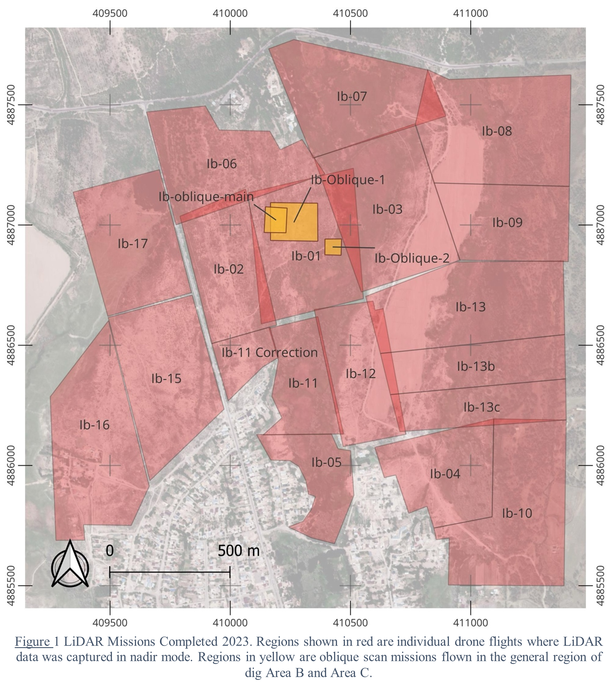
Flight missions were set to capture either nadir or oblique scans of the terrain. Nadir scans (the majority of missions flown) involve pointing the LiDAR scanner directly downward so that the laser pulse direction is generally perpendicular to the scanned surface below. Oblique scans set the laser pulses at an oblique angle (e.g. 45°) to the scanned surface, such that the LiDAR unit is essentially looking at its subject from the side. The oblique scan mission consists of five flights of the subject area, four from the cardinal directions observing the subject from an oblique angle, and one from a nadir position. The five resulting point clouds are then merged post-process into a single model yielding more clarity of the three-dimensional characteristics of the object. Oblique missions were flown to scan the immediate dig site, once in the middle of the expedition, and once at the end.
Data Processing and Analysis
Proprietary software DJI Terra was used to provide initial processing of the raw data recovered from the LiDAR unit post-flight. The primary function of this initial processing is to apply either the real-time kinematic (RTK) GNSS corrections or the post-process kinematic (PPK) GNSS corrections to the point cloud, increasing the GNSS precision of each point from a few meters to a few centimeters.
Once the raw data was processed, it was exported to a non-proprietary point cloud format for further analysis with other point cloud and GIS software tools. This specialized software offered the ability to visualize and manipulate point cloud data in various ways. For our purposes, primarily four capabilities were utilized: 1) filtration of point cloud data to distinguish ground plane points from above-ground objects, 2) scalar colorization of the model’s z-axis data for visual identification of ground surface anomalies, 3) generation of contour plots from which topographic maps could be created, and 4) distance, location, and geometry reporting.
As the primary interest in employing LiDAR on this project was the analysis of the ground surface shape or topography, a first step in processing the point cloud was to utilize specialized algorithms that could distinguish “ground points” from “above ground points.” The result of this process yields a point cloud where much of the vegetation points are removed and visualization and analysis of the ground surface can proceed with more clarity.
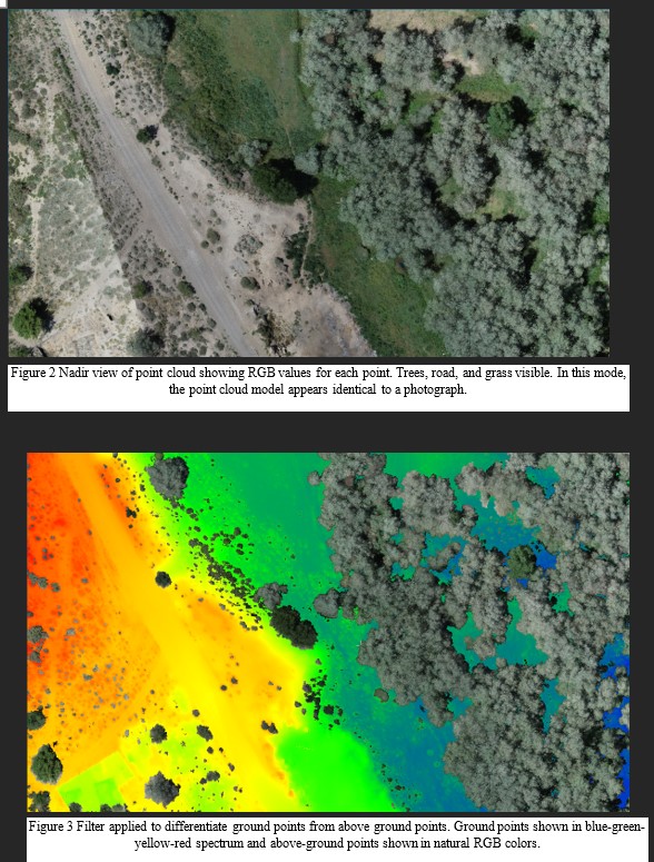
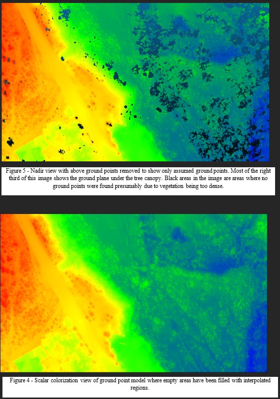
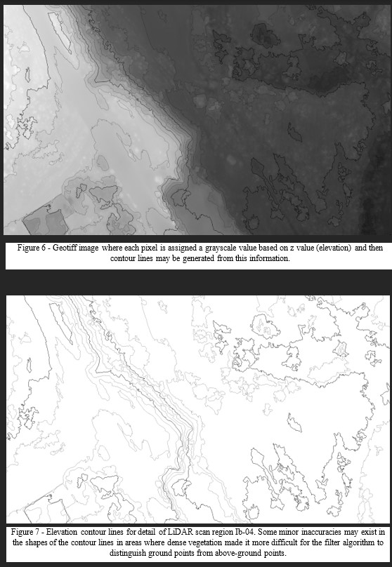
The images below (Figures 2 through 4) illustrate this part of the process. Figure 2 is a top view detail of the resulting RGB colored point cloud from scan Ib_04. Note the location of the trees in this view. Figure 3 is the same location on the same scan, but where CloudCompare has attempted to differentiate points representing the ground plane from points representing above-ground elements (vegetation, buildings, etc.). Figure 4 shows the same view, but this time with the above-ground points hidden to show the density of point information at the ground plane. Note that in this area of the model even under the tree canopy, it is possible to fully comprehend the shape of the ground plane. (Note that this level of ground plane topography information is non-existent in photogrammetry generated models).
Scalar Field colorization is rendering a point cloud such that each point is colorized on a given spectrum based upon some predetermined type of information about that point. For example, a point cloud might be rendered on a spectrum of blue to green, where dark blue points have the lowest z-value (elevation), and bright green points have the highest relative z-value (elevation). Such a rendering visually illustrates areas of the model which are higher or lower based on the color, even if one is viewing the model from above. Scalar colorization was heavily utilized during visual analysis of the Ilibalyk LiDAR scans.
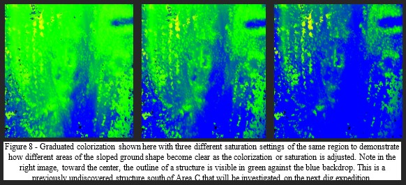
Ilibalyk was located on a topographic plane that slopes gently downward to the south. Moreover, the creek in the middle of the site means a depressed region along the center of the ancient city. In the case of field IV of the excavation site, the slope is both to the east (the creek) and the south. Including the entire area scanned with LiDAR during the 2023 expedition, there was an overall difference in elevation from highest to lowest point of over 30 meters across nearly 2.2 km horizontal distance. The significance of this during analysis of the point cloud data using scalar field colorization is that a sloped site will display a spectrum of color merely by nature of one end being higher and one lower, distracting from color differentiations that would indicate local features of the surface shape. Consequently, to visually exaggerate surface anomalies on a sloped ground plane, the color spectrum parameters must be adjusted for each respective section of the sloped ground plane moving from north to south or vice versa. This is illustrated in the images of Figure 8.
Interpretation and Results
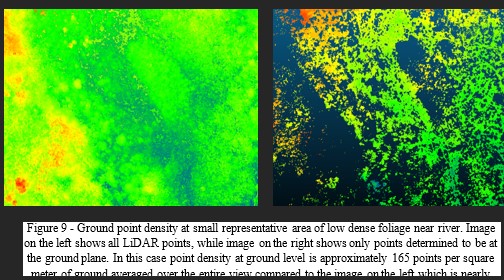
Scan regions Ib-03 and Ib-07 (refer to map above) represent regions that are heavily covered in dense low foliage. Figure 9 shows the filtered ground points in a small representative area of region Ib-07. The point density of the ground points in this region is 165 points per square meter. This contrasts to some areas with tree coverage (high foliage) which has a higher average point density of 215 points per square meter. The whole model density (ground and above-ground points) is as high as 1500 points per square meter. The result is that any interpolated ground form in dense foliage areas has relatively low reliability. It is possible to locate the ground elevation due to the fewer points that are captured at the bottom of the foliage but point density at the ground plane is too low to reconstruct the ground form in such a way that would display shape characteristics of value for our uses. This may not be entirely problematic in all cases. These densest areas of vegetation are generally found at the lowest part of the valley along the river. As our primary interest is finding new areas of the populated rabad for excavation, we can assume that these densest foliage areas are too low in the flood plane of the river to be a realistic location for most human-made structures. Should it be determined that there is value in obtaining a ground plane model with higher reliability in these low, dense foliage areas, additional LiDAR scanning should be conducted in the fall months after most leaves have fallen.
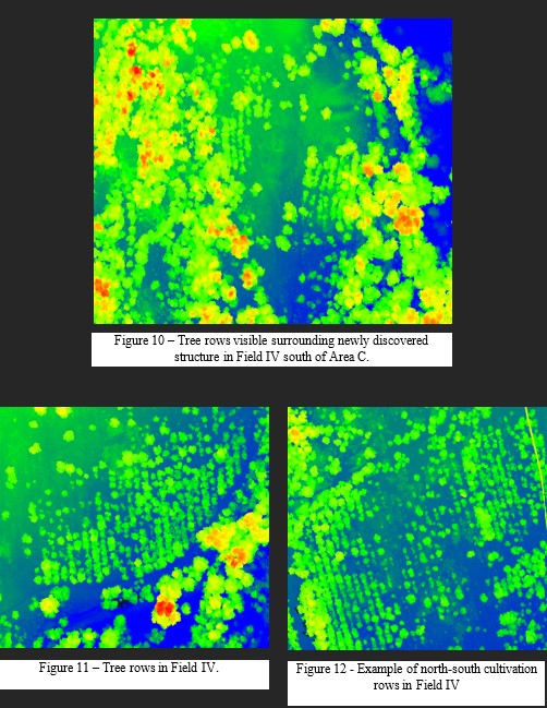
Agricultural activity from the previous two centuries in the vicinity of the medieval Ilibalyk site has re-textured the ground surface over a large portion of the overall area scanned. In the region immediate to Field IV, satellite and aerial photography reveal a discernable pattern of cultivation rows oriented generally north-south, parallel to the direction of slope. See Figure 12, Figure 11, and Figure 10. Measurements of the LiDAR model in these areas indicate an average row to row width of approximately 3.5 meters. The shape of the ground plane corresponds with the visible lines of trees. The ground texture in these areas is a clear ridge-and-furrow pattern on 3.5 meter centers with trough-to-crest elevation difference typically between 10 and 30 centimeters.
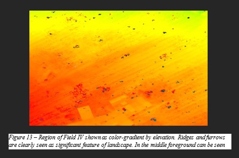
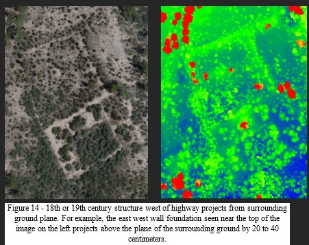
Given that our main objective in employing LiDAR on this project is to aid in finding locations of medieval structures below ground, it is important to consider how this ridge and furrow ground texture hinders us in this task. Figure 13 employs scalar field colorization to help visualize the ridge and furrow texture of the ground around Areas A and B. The orange striations in the image are the 10 to 30 cm elevation difference from furrow to crest mentioned above. Now consider the structure foundations from the 18th and 19th centuries known to exist sub-surface from in the region to the west of the highway (see field report from 2016). At these locations, the ground surface at the presumed structure location projects slightly above the surrounding grade. We can measure the amount of this projection and compare it to the ground surface re-texturing in the cultivated regions of Field IV. Such a comparison suggests that the dimensions of the furrows in regions such as Field IV are sufficient to obscure indications of structures that might otherwise be discoverable with LiDAR data analysis. Put differently, the furrows are deep enough that they would theoretically erase otherwise noticeable surface traces of structures where they occur. Figure 14 shows an aerial photo and color gradient view of a structure assumed to be from the 18th or 19th centuries located west of the highway. The greatest elevation difference between surrounding ground level and level on top of foundation is approximately 40 cm. The ridge and furrow ground texture in Field IV may potentially be preventing our detection of similar underground structures that may exist there.
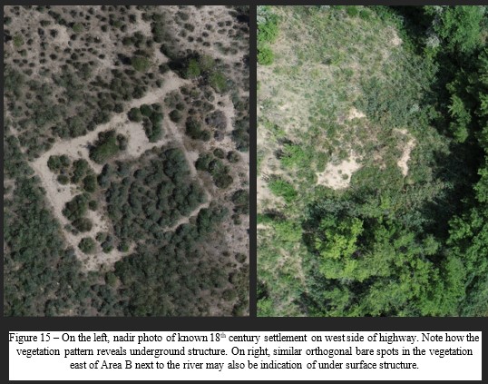
Analysis of the aerial photography that was captured during the LiDAR scan process may have yielded another approach for determining location of sub-surface structures. Nadir photographs taken in the 18th/19th century area west of the highway reveal a distinctive pattern in the distribution of plant growth in certain places. It may be hypothesized that the bare areas in these images (see Figure 18) are due to underground structures. The orthogonal arrangement and length of these bare areas suggest the presence of foundation walls for either enclosed structures or stand-alone walls. Notably, Figure 15 shows how an area in Field IV shares similar characteristics to the afore mentioned area west of the highway. The image on the right is located east of dig Area B, adjacent to the river. A discernable rectangular shape rotated slightly to the east may be inferred from ground vegetation pattern. Further examination of plant distribution and growth as seen in the aerial photography may offer additional insights, guiding the identification of areas warranting further investigation.
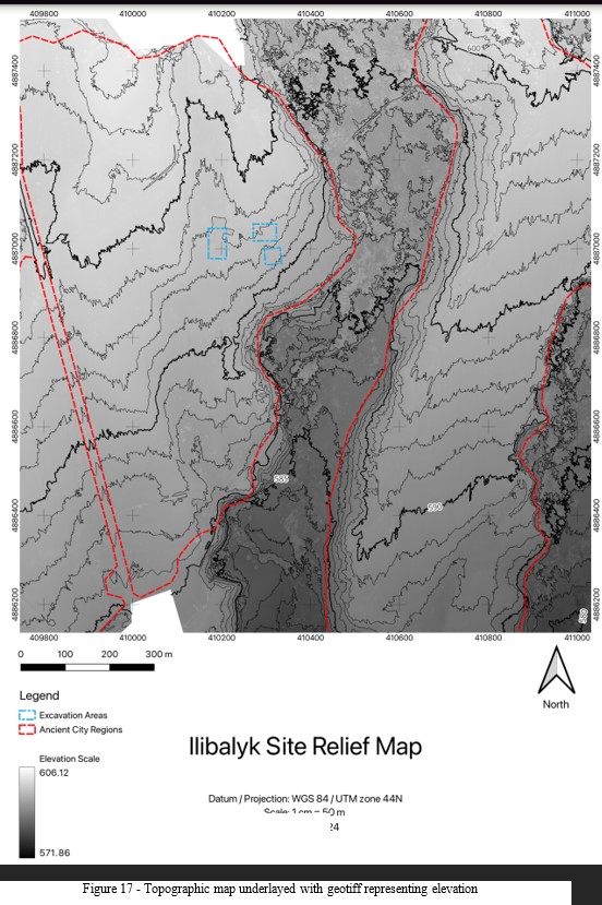
LiDAR data captured in 2023 was used to create detailed topographic maps. These maps allow us to analyze the physical landscape of Ilibalyk, providing insight into its layout, infrastructure, natural features, and relationship to the river. For example, we are now able to understand more clearly the locations and routes of the irrigation channels located throughout the scanned area.

Figure 16 - Topographic map generated by processing LiDAR data from 2023 scans of Ushural/Ilibalyk region
Other Considerations
Commercial utilization of remotely operated flying systems in Republic of Kazakhstan airspace is governed by Order No. 706 of the Ministry of Industry and Infrastructure Development from 2020 and subsequent revisions (The ministry was reorganized and divided in 2023 into the Ministry of Transportation and the Ministry of Industry and Construction). The dig team endeavors to be compliant with all local and federal regulations regarding the registration and use of unmanned aerial vehicles whether for the purpose of LiDAR scanning or photogrammetry. See bibliography for links to official regulation sources.
Conclusion
The LiDAR scan activities during the 2023 expedition provides precise and high-resolution data for analyzing ground surface characteristics. The technology's ability to penetrate vegetation offers a distinct advantage over other methods like photogrammetry, particularly in areas with dense shrubbery and trees. Analysis of the LiDAR-generated point clouds is facilitating the identification of potential anomalies indicative of sub-surface structures. While agricultural reshaping of the ground surface reduces the usability of the data in many areas, the LiDAR data is providing valuable insights for ongoing excavation efforts. Integration of LiDAR technology into the archaeological investigations at Ilibalyk is offering a nuanced understanding of the site's overall topography adding to our understanding of how the settlement in this area was organized, and its relationship to the river. The point cloud data captured in 2023 will continue to be analyzed with various visualization and filtering techniques with the purpose of potentially leading the team to new areas for excavation.
Bibliography for LiDAR Report Section
- Утверждены правила эксплуатации беспилотных летательных аппаратов в воздушном пространстве Республики Казахстан https://online.zakon.kz/Document/?doc_id=38097460
- Как можно использовать дрон в Казахстане — в МИИР напомнили правила https://www.zakon.kz/tekhno/6015766-kazakhstantsam-napomnili-o-pravilakh-ekspluatatsii-dronov-v-vozdushnom-prostranstve.html
- приказ Исполняющего обязанности Министра индустрии и инфраструктурного развития Республики Казахстан от 31 декабря 2020 года № 706 Об утверждении правил эксплуатации беспилотных летательных аппаратов в воздушном пространстве Республики Казахстан, http://law.gov.kz/client/#!/doc/181230/rus
- Crutchley, S., & Crow, P. (2018). Using airborne lidar in Archaeological Survey: The Light Fantastic. Historic England https://historicengland.org.uk/images-books/publications/using-airborne-lidar-in-archaeological-survey/heag179-using-airborne-lidar-in-archaeological-survey/
- Herrera, V. M. (2017). Archaeology et geomatics: Harvesting the benefits of 10 years of training in the Iberian Peninsula (2006-2015). Sidestone Press.
- Štular, Benjamin and Lozić, Edisa. "Airborne LiDAR data in landscape archaeology. An introduction for non-archaeologists" it - Information Technology, vol. 64, no. 6, 2022, pp. 247-260. https://doi.org/10.1515/itit-2022-0001
- Cowley, D. C., & Opitz, R. S. (2012). Interpreting archaeological topography: Lasers, 3D data, observation, visualisation and applications. Oxbow Books.
- DJI Zenmuse L1 User Manual https://dl.djicdn.com/downloads/Zenmuse_L1/20210518/Zenmuse_L1%20_User%20Manual_EN_1.pdf
- DJI Matrice 300 RTK User Manual https://dl.djicdn.com/downloads/matrice-300/20200507/M300_RTK_User_Manual_EN.pdf
- DJI Smart Controller User Manual https://dl.djicdn.com/downloads/smart+controller/20190110-2/DJI_Smart_Controller_User_Manual_EN_V1.0_0110.pdf
- Kersten, T., Wolf, J. and Lindstaedt M., Investigations into The Accuracy of the UAV System DJI Matrice 300 RTK with the Sensors Zenmuse P1 and L1 in The Hamburg Test Field, The International Archives of the Photogrammetry, Remote Sensing and Spatial Information Sciences, Volume XLIII-B1-2022 XXIV ISPRS Congress (2022 edition), 6–11 June 2022, Nice, France, https://isprs-archives.copernicus.org/articles/XLIII-B1-2022/339/2022/isprs-archives-XLIII-B1-2022-339-2022.pdf
Unit and Loci Descriptions
Excavations during the 2023 opened 2 new units (excavation trenches)—specifically Units 17 (23 E/W x 3 N/S m) and 18 (5 x 5 m). Further excavations were conducted in Unit 12—east and north of the previously identified funerary chapel first discovered in 2020—and Unit 15, an area of elite graves initially revealed in 2021. In total, 67 loci were identified, 8 of which had been designated in previous seasons such as graves that had not been excavated. In addition to the 10 graves excavated (1 in U-12, 5 in U-15, and 4 in U-17) an additional 15 probable graves were discovered in which time limitations prohibited further investigation. These discoveries expanded the known boundaries of the cemetery in Area C. In Unit 12 to the north of the northern wall of the funerary chapel as series of test trenches, along with an expansion of L-185, revealed what is currently interpreted as a martyrium that served as a possible northern annex to the chapel, or stood as a separate structure, such as a mausoleum. Excavation on the far east side of U-12, which extended beyond the eastern wall of the chapel, revealed two additional walls, one of which was a possible retaining wall for the eastern half of the structure (L-383) and the other (L-361) which may be from an earlier construction phase of an unknown building and extended the length of the unit along its north-south axis. (Appendix “Photos”. Fig. 1-4)
The following loci descriptions are grouped according to their excavation units in numerical order. All these loci are within Field IV, Area C. (Appendix “Drawings”. Fig. 1-5).
Unit 12
This unit was first excavated in 2020 and was initially delineated as a 32 E/W x 22.5 N/S m area, which at the time, was the most southern boundary of the excavation in Area C. The 2020 excavation revealed what is currently interpreted as a funerary chapel (See 2020 Field Report, pp. 70-77; 2021 Field Report, pp 5-6, and 2022 Field Report pp. 115-127). Cultural material finds and the architectural layout (E/W orientation, identified nave and altar area) continue to affirm the ecclesiastical identification of this structure. The 2023 excavation objectives involved further investigation of the area north of the chapel, specifically Locus 185, from which significant cultural finds, including a metal cross, glaze ware pottery, and a kayrak (L-234), were discovered. Excavators surmised that this section’s area needed to be lowered by several centimeters to better discern this northern section’s relationship to the chapel. In addition, 2 loci (L-257 and L-258), characterized as rectangular shaped features but indeterminate as to function called for closer examination. The results, as detailed below, exceeded expectation with the discovery that Locus 258 was a grave of high status and contained within the possible martyrium and L-257 a possibly grave laying adjacent and parallel with L-258. Due to safety concerns that arose in excavating these two graves that were immediately next to each other, excavation of L-257 was delayed for potential excavation in a future season. Additional graves in and around these two main graves were also detected but are currently obstructed by trees (Appendix “Drawings”. Fig. 6).
As when first discovered in 2020, the chapel area at the conclusion of each season’s excavations had been covered with geotextile to preserve the mudbrick and paksa (tamped earth) wall foundations. This has proven quite effective as the revealed structures remain in good condition. After sweeping the chapel, a 3-D lidar scan by an iPad Pro was successfully completed to be added to the database. Two artifacts sitting on the nave floor (Locus 230)— the base of a bowl and an animal bone—were cleared and catalogued.
The backfill soil, which created a thick layer upon the geotextile contained a few potsherds, which was expected, yet none of these sherds can provide any diagnostic information or can be considered even from the soil matrix since this backfill soil has been removed and replaced several times.
This section, designated L-185, contained a cluster of two small fruit trees hampering excavation efforts, was expanded to the south and west in 2020. This section lies between the cemetery of Area C and the funerary chapel. It also yielded additional pottery finds, including two 4-nozzel lamps (L-338), possibly used to light the martyrium. South of this section and near what appeared to be a retaining wall and platform parallel to the altar area, a completely whole vessel (L-346, a medium-sized storage jar, known as a khumcha in Russian) with an intentionally rounded, secondarily used fired brick stopper was discovered which had been inlaid at the floor level, likely utilized for storage of food stuffs or drink.
The medieval occupational surface was discerned in this section and the area identified as L-185 had gray-colored soil (Munsell 10YR 7/2), likely because of trampled ash like that discovered within both the altar area (L-240) and the chapel nave (L-230). This same-colored soil has often been found within the mudbricks of many graves within the cemetery (See 2021 Field Report, pp. 97-98). The area with the gray-colored soil appears to be contained within the possible enclosure of the currently interpreted martyrium and was possibly an enclosed structure. Further excavation will be needed to see if this potential structure was a self-contained building or an annex to the chapel.
Examination of the chapel on the east side of Unit 12 discerned a second wall (L-361), thought to possibly be a retaining wall that formed a semi-circular enclosure around the altar. Thus, the team decided to expand excavations to the east within the previously exposed boundaries. This area was contained within the initial boundaries of the previous excavation and was more definitely demarcated as a 5 EW x 16.5 m (82.5 m2) unit. Since this area was contained in the previously designated Unit 12, no additional identification was given. The purpose was to determine if any other features, cultural material and/or graves might be present. While clusters of pottery (including archaeologically whole vessels) and ash pits were discovered, no graves were discerned. (Appendix “Drawings”. Fig. 5).
The eastern, southern, and northern sides of U-12 is adjacent to the usual collection of trees as throughout Field IV, in which dense tall herbaceous vegetation, colloquially called wormwood (Artemizia) grows, along with low-growing shrubs and trees of the Laeagnus commutata variety (silver oleagenin). Additionally, wild apricot trees related to the common apricot (Prunus armeniaca Lin., Armeniaca vulgaris Lam) can be found. The soil in this eastern sector of U-12 is similar in type, color, and description as throughout the excavation site. The initial level for this northern sector of U-12, which marked the soil below the cleared surface first revealed in 2020, was designated as Locus 334 and is described below.
In total, 35 new loci were identified, and 3 previous loci were investigated, comprised of test pits in the northern sections, ash pits, pottery features, and two graves, one which was excavated (L-258).
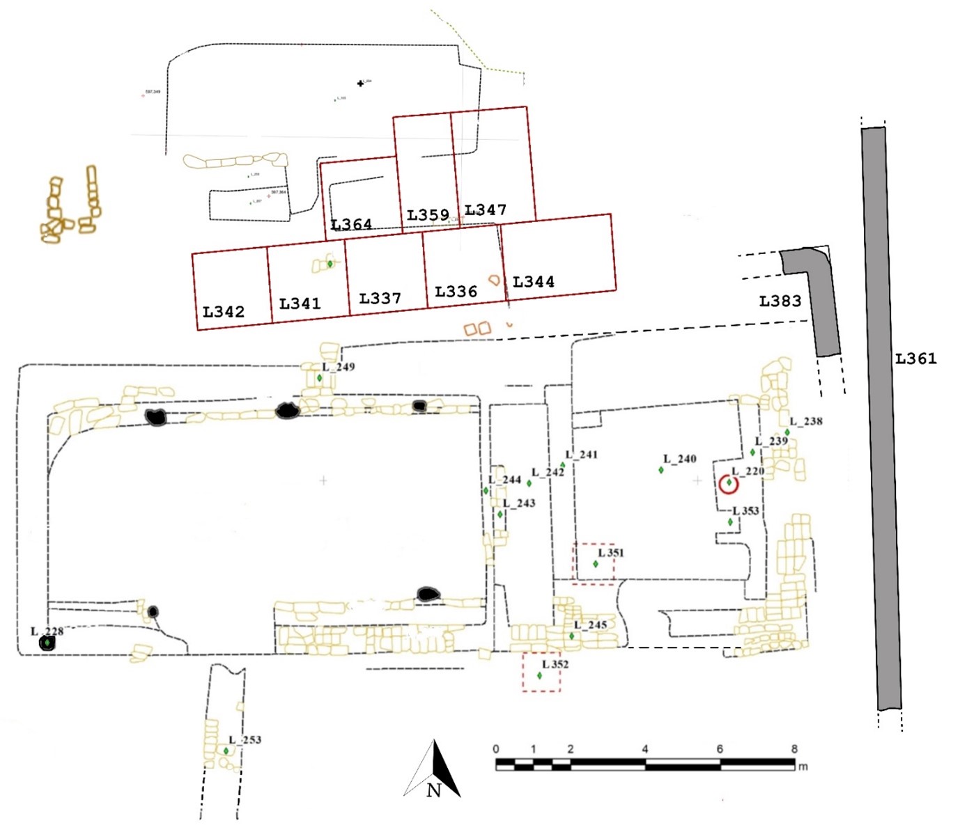
Fig. 18. Loci excavated (and or investigated) in Unit 12, supervised by C.A. Stewart in 2023, in relation to previous season(s). Measurements and orientation are approximate. L-333 incorporates all the sub-divided test pits and the is designated level between the surface at excavation and the identified medieval occupational surface.
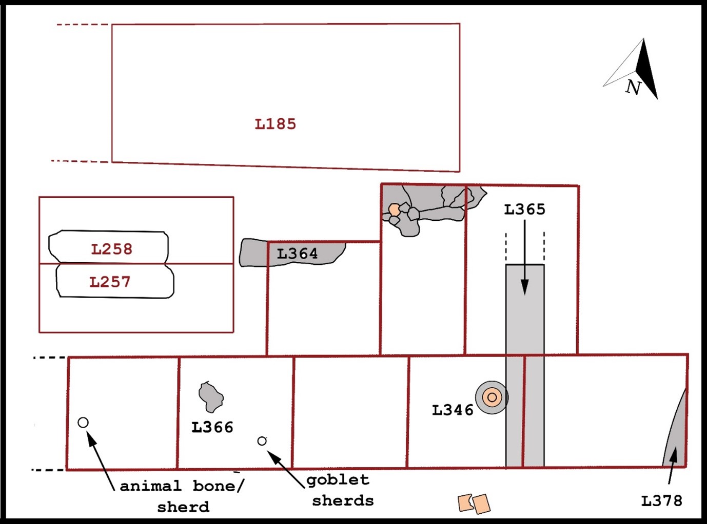
Fig. 19. Top plan of Loci excavated (and or investigated) in Unit 12, supervised by C.A. Stewart in 2023. Measurements and orientation are approximate.
Locus 185
Level
(Appendix “Photos”. Fig. 5-7)
This locus, initially demarcated in 2019, lay on the south side of the cemetery at the south baulk of Unit 9C, identified as “ashy-colored soil” (2019 Field Report, p. 111). It was also in 2019 within the soil matrix of this baulk that a 5 x 5 cm copper cross in the cross patee (equilateral) style was discovered (depth 597.384 m. asl.; Ib_19_C_IV_001_I025; 2019 Field Report, pp. 7, 228). Two of the opposing crossbars contained pierce holes on each end. The Initial interpretation was that this cross might have been possibly nailed to coffin or hammered to a wall as a decorative piece. This interpretation was further bolstered when a kayrak (gravestone) (20.6 x 17.7 cm) with a simple cross inscription was discovered the following year (2020 Field Report, p 52, Ib_20_С_IV_I234), yet at a higher depth than the metal cross (597.703 m. asl.) by 31 cm. This kayrak was discovered about a meter away from the cross’ findspot.
In 2020, with the discovery of the funerary chapel in Unit 12, due south of L-185, the archaeology team began trying to discern the relationship between L-185 and the chapel itself, particularly because of the gray soil which continued to be revealed as more upper soil began to be removed. What was first thought to possibly be the typical, gray-colored mudbrick which has covered many of the graves in the cemetery, was now apparently some type of floor surface. (2020 Field Report, pp. 13-14). The dense, gray-colored surface contains many flecks of charcoal, which initially led excavators to conclude that the surface was exposed to burning, and possibly part of an open-air courtyard. The excavation, complicated by a cluster of fruit trees, continued to reveal this floor to the west. Yet, by the conclusion of the 2020 excavation, no connection with the chapel had been determined.
As part of the 2023 excavation goals, understanding the northern territory that incorporated the chapel was priority. Thus, excavators sought to fully reveal the gray-colored surface. Eventually, it was determined that this surface was compacted (possibly due to human traffic) with the interspersed charcoal fragments a part of ash that had possibly been intentionally deposited on the floor’s surface, as opposed to being an ash layer from a catastrophic fire, however, this latter hypothesis cannot be fully ruled out.
Initial level measurements were taken with the total station: SW: 597.321; NW: 597.342; NE: 597.371; SE: 597.561 m. asl. The modern surface level with the cluster of fruit trees was also measured: 597.970 m. asl.
After excavation commenced, in the northern area of L-185 [Block 1], an unglazed lamp nozzle was found along with a brick fragment, this appeared in situ as it was found under the geotextile. This find was in the soil fill near the two trees which, as mentioned, was also the location of several previous finds, including a kayrak (L-234) discovered in 2020 and a metal cross (Ib_19_C_IV_001_I025) found in 2019. While clearing new soil in and around the area of these trees, additional pottery was discovered, including what appeared to be a large, rounded knob connected to a vessel. This piece was left in place as it extended lower than the currently cleared surface. Photos were taken and an initial total station level was taken: 597.400 m. asl.
More pottery fragments were discovered in this northern section of L-185, including 3 blue glazed pieces that were possible fragments from an archaeological whole vessel discovered near the same spot in 2020 (Ib_20_С_IV_ 185_I002). Due south of these two pieces were 2 parallel fired bricks which appeared in situ. In addition, light gray soil was found under and surrounding these bricks with a boundary or edge running in an east to west direction. Tree obstruction continued to hinder this investigation. While initially thinking the edge demarked a grave, it became clear that these bricks are more likely in conjunction with a wall line extending from the chapel or part of the later identified martyrium.
While continuing to peel back soil around trees to discern possible feature(s) under trees and around the 2 fired bricks on the northeast side an attempt was made to discern the function of fired bricks. What initially was thought to be mudbrick with a burial chamber was hardened soil. The soil was lowered on both sides of the bricks so they would be on the same level with both sides of the bricks. More large pieces of charcoal were found west of the bricks.
The soil area between the two trees was lowered. No cultural material was found in the first 30 cmbs, but, then at approximately 40 cm above the cleared surface, 2 other fired bricks were revealed, these lying horizontally. These bricks were at a slightly higher level than the other bricks on the northeast side of L-185. The first brick measured at a level of 597.615 m. asl. and the second brick to the south measured 597.575 m. asl. and they were separated by approximately 30 cm. The soil fill between the trees was then lowered to match the level of nearby L-333 and a few pottery sherds found, including a small piece of green glaze ware. Also discovered was a small piece (get dimensions) of worked bone possibly calcined by fire and part of a possible utensil, yet this is uncertain.
As excavations continued, focus was turned to the ceramic feature which initially revealed a four-nozzle lamp, virtually complete, yet with two revealed nozzles broken at the intersection with the vessel’s body. Immediately south of this vessel, another round decorative pottery fragment was discovered, thought to be a broken fragment of the first vessel. However, when proceeding to remove the 4-nozzled lamp, a second lamp also with four nozzles, yet with a variation in style, was discovered next to the original find. Both vessels lay at a slight angle parallel with each other, with the first partially on top of the second. Due north of these vessels, large wood fragments was also discovered, which appeared to be either from a large root, but more likely, wood flooring or even fragments from a box or chest, yet no complete determination could be made. A new locus was assigned to this pottery feature, Locus 338.
The soil in and around the 2 lamps was then cleared to reveal the occupational surface more clearly, and it appeared that the lamps may have been buried slightly lower than the occupational surface, or perhaps inside a container, yet no wood that might have been found from the floor of a container was discerned. To the west of the lamps, yet another pottery feature was discovered. This appeared to be a round slightly hollowed cylindrical piece, which eventually was identified as a base to a vessel It was assigned a locus number, L-339 (see locus description). Both features were measured with the total station: L-338 Lamps, Level 597.285 m. asl. L-339 Cylindrical pottery piece 597.291 m. asl. Thus, these pieces were likely deposited in this area, possibly deliberately, and at the same time.
Wood continued to be found on the gray-colored occupational surface and an attempt was made to trace it both to the east and west immediately north of the section with these pottery features. This area lay on the borders between U-12 and U-9C. Possible mudbrick was observed with this wood and what appeared to be border lines on both the north and south of the wood feature. Excavators initially thought it marked a grave with a wood cover (such as previous discoveries in the cemetery, L-146, L-291, and L-317), yet uncertainty remained as to whether the wood was natural roots from the obstructing trees, or if it was some type of flooring. Most certainly contemporary roots were seen on this level, however, they appeared to be tracing along the possibly wood planks. The ceramic features (L338/339) were kept in situ for a longer period in hopes of determining the full context. This wood feature was given a locus (L-340) with a total station level taken: 597.294 m. asl.
As excavations continued, in the northeast corner of the revealed, gray-colored surface an area of burning (calcined, red soil) was found along with an ash spot. The wood fragments proceeded across the entire area, and it was determined that the pottery vessels were probably sitting on top of the wood, which were planks of about a 1 cm wide to 1.5 cm thick, though it remained difficult to discern. Final clearing with a mechanical blower revealed a line of 5 single course mudbricks, to the east of the pottery feature by approximately 1 m and extended 1 m long proceeding in an approximate north-south direction immediately parallel with the gray-colored surface. The bricks were not in a perfectly perpendicular straight line but appeared to extended north/northwest along the edge of the gray surface. A possible hypothesis is that this section of L-185 was possibly part of a foundation for a wood structure or floor that stored vessels or the line which appears to be in line with the whole khumcha pottery feature, L-346. This area of L-185 currently does not appear to contain a grave, though the final determination is still not made due to the obstruction of the trees.
Once the context of the east side of L-185 was better determined, the lamps (L-338/L-339) were removed and carefully packed for later investigation and cleaning in the field lab. Both lamps had 4 nozzles, yet not all of them were intact or had survived unbroken. The feature in L-339 was the base to a chalice which was later confirmed in the field lab and matched with another fragment to this based that was discovered in L-341. Soil and wood samples were bagged for later analysis.
L-185 was then extended to the west for the purpose of tracing the gray-colored, compacted soil floor. It was extended to the west by 10.6 m and to the north by 2.4 m. As the tracing continued, a “turn” to the south at approximately 3 m to the west of the gray-colored flooring was detected which extended to the south just beyond the western side of the grave boundary discovered in L-258. This means that this grave and the probable grave immediately parallel (L-257) were contained within a structure, some form of mausoleum or martyrium in conjunction with the chapel. The 20-cm thick, compacted gray layer with ash and large flecks of charcoal may be indicative of the ceremonial use of ash in Syriac funerary practice (Wiśniewski 2018, 168; Wickes 2015, 120; Brock 2009, 180).
Also, in the northern extension, on the northwest side of the gray-colored flooring, a soil change was detected, containing loose sandy loam with small pebble-sized gravel and soil with a yellowish tint and no charcoal inclusions. It extended 100 cm east-west and could have served as a possible north entrance from the martyrium to the cemetery. Regardless of its function, it was outside the boundary of the gray-colored floor.
Since the soil around the tree could not be completely removed, a profile was created by the excavators to possibly detect features within an “unexpected” south baulk (230 cm) and a smaller east baulk (80 cm). This profile was then drawn (described below). The south baulk profile revealed at least 3 clusters of mudbricks, which may indicate detrital collapse or some other feature, such as grave(s). The level of the compacted, gray-colored floor was also clear within the profile and was approximately 12-20 cm thick with the bricks extending below and into the surface. This indicates possible phasing and with the usage of the structure under investigation over a long period. It also suggests that the lamps were deposited in a hole in the floor later, which might indicate rapid flight with the hope of eventual return, or some sort of ceremonial destruction of what would be considered sacred vessels by the community.
Stratigraphy Profile Description (L-185)
An east-to-west line of three fruit tree clusters in the central section of L-185 were kept in place to adhere with state regulations within the protected land area in which Areas A, B, and C of the cemetery excavations have occurred. The two tree clusters on the far eastern side of L-185, which stand east of the probable grave (L-257) and the excavated grave, (L-258) impeded the team’s ability of fully interpret the supposed martyrium that resides north of the funerary chapel. During this season, excavators sought to remove soil as closely as possible around these trees without creating permanent damage. In addition, an 80 cm stretch of soil to the west of the easternmost tree was shaved closely to create a baulk face in which to read the stratigraphy. The same was done with the soil of the other tree to the west, this time on the north side of the tree, creating a south baulk face extending 230 cm from east-to-west. The following descriptions detail the features as recorded within the profiles of these two baulks.
East baulk profile
This profile of the 80 cm east baulk of L-185 (within U-12) was characterized by three layers: an intermixed layer of topsoil from the plow zone and current excavation work, a layer of sandy silt, and a light brownish gray layer of compacted floor.
1. An intermixed layer of topsoil from the plow zone and current excavation work. This first layer of the profile was comprised of a light gray (Munsell: 10YR 7/2) sandy silty loam ranging 40 cm deep on the north side to 45 cm on the east side of the profile This layer extended across the 80 cm length of the profile and completely covered the sandy silt layer that lay under it. The soil was intermixed with soil from both the Soviet-era plow zone and the backfill from previous excavation work that was first initiated in Area C in 2017. The soil had inclusions of root systems and from churned up humus. No cultural material was visible in the soil.
2. A layer of sandy silt. This second layer of the profile was comprised of a pale brown sandy silt (Munsell: 10YR 7/2) with the top of the layer ranging from 40 cm on the north side below the surface and descending to 47 cm on the south side below the surface. The layer’s width ranged from 15 cm on the north side and descended southward to a width of 7 cm. The base of this layer overlapped the lower gray layer of compacted flooring and extended evenly across the entire profile. The layer had root disturbance and root systems with no other inclusions.
3. A light brownish gray layer of compacted floor. This third layer of the profile was comprised of a compacted light brownish gray soil (Munsell 10YR 6/2) with multiple pieces of black charcoal inclusions. The top layer appeared 55 cm below the surface and extended evenly across the entire length of the profile. It was 30 cm wide. This layer is interpreted as the floor to the martyrium. No mudbricks were seen within this layer.
South baulk profile
This profile of the 230 cm south baulk of L-185 (within U-12) was characterized by three layers and 1 feature: an intermixed layer of topsoil from the plow zone and current excavation work; a layer of sandy silt; a light brownish gray layer of compacted floor; and three mudbrick clusters within the compacted floor.
1. An intermixed layer of topsoil from the plow zone and current excavation work. This first layer extended from the 85 cm demarcation rather than across the entire baulk since the top two layers on the east side of the baulk had been removed due to excavation. This layer was comprised of a light gray (Munsell: 10YR 7/2) soil which was a mixture of Soviet-era topsoil and backfill from previous excavations that began in 2017. It contained much churned humus and root inclusions. Its length, from the 85 cm mark, was 145 cm and its width ranged from 27 cm on the east side 7 cm on the west of the profile. It overlapped across the entirety of the sandy silt layer. Inclusions of red clay pottery were visible within the cross section.
2. A layer of sandy silt. This second layer extended from the 85 cm demarcation rather than across the entire baulk since the top two layers on the east side had been removed due to excavation. This layer was comprised of and very pale brown (Munsell: 10YR 8/3) sandy silt. It contained inclusions from the tree root systems as well as cultural material such as red clay potsherds and possible fired brick fragments. Its length, from the 85 cm mark, was 145 cm, with an undulating width ranging from 17 in the central section of the layer to as narrow as 4 cm at the 190 cm mark on the west side. Its depth below the topsoil ranged from 27 cm on the east side to 7 cm on the west side. It is possible that the undulating nature of this layer is due to the presence of mudbrick which this layer may have eventually covered. These bricks may be from possible graves which were a part of the martyrium, though this is speculative.
3. A light brownish gray layer of compacted floor. This third layer of the profile was comprised of a compacted light brownish gray soil (Munsell 10YR 6/2) with multiple pieces of black charcoal inclusions. This layer’s length extended across the entire 230 cm of the profile. On the east side, this floor had been exposed from excavation. The upper two layers then covered the flooring starting at the 85 cm mark. The floor began to ascend slightly at the 100 cm mark, reaching its peak at the 190 cm mark, being 10 cm higher and then descending again by 10 cm on the west side of the profile. The black charcoal inclusions, some up to 7 cm wide, were interspersed throughout the layer. The soil was hard and compacted, yet some roots from the tree appear to have penetrated the layer on the west side of the profile. Three clusters of mudbrick, some gray, some with a reddish-brown tint, were also visible within this floor layer.
4. Three mudbrick clusters within the compacted floor. This feature within the third layer of the profile manifests itself as three clusters of mudbricks. The first cluster began at the 18 cm mark with a large amorphous mudbrick (approximately 30 x 10 cm) of reddish-brown tint quite visible within the compacted floor of the third layer. Additionally in this first brick cluster were three bricks with this same color (approximately 23 x 7 cm) in a straight line 10 cm higher in the profile beginning at the 23 cm mark and proceeding eastward and terminating at the 75 cm mark. The second cluster of bricks began at the 100 cm mark with three mudbricks in a perpendicular line from the base of the baulk. The bottom brick was reddish-brown (15 x 7 cm) with an amorphously shaped gray mudbrick immediately on top of the bottom brick. This gray brick measured 15 x 7 cm. A third gray mudbrick appeared to have been placed on top of the second brick in a perpendicular position (15 x 7 cm) with a smaller fourth brick (10 x 5 cm) adjacent to the west and perpendicular (90 degrees) to the west of this third brick terminating at the 120 cm mark. The third cluster of bricks were comprised of four mudbricks of various sizes in a straight line across the base of the profile beginning at the 140 cm mark and extending to the 213 cm mark. The first brick was gray and measured 20 x 10 cm, the second brick—due east with the east end slightly below the bottom boundary of the baulk—was reddish-brown and appeared broken with significant detritus. The third and fourth mudbricks (which may be part of one brick) were gray with reddish-brown inclusions, measured approximately 10 x 5 in the baulk. It is possible that the bricks in the second and third clusters are part of the same feature, likely a grave.
Locus 257
Probable grave
This locus, as well as L-258, were first revealed and identified during the 2020 excavations and described as being a “feature of bricks and loam.” (See 2020 Field Report, p. 27-28). In L-257, the soil was described (and remains) as a “light brown loam” almost reddish, in contrast to the gray colored soil and faintly discerned bricks for L-258. Even at the early stage of excavations of 2020 which revealed the funerary chapel, the team was intrigued by these two large rectangular features and speculated that both loci, based on their size and east-west orientation, might be graves, and even speculated it might be included as part of a mausoleum. Yet, the trees, planted within the past 2-3 decades, have consistently hampered access and the ability to interpret this section archaeologically.
The following season (2021), the excavation objectives included further investigation of both L-257 and L-258 attempting to confirm whether these features were graves (2021 Field Report, p. 7). Despite troweling these loci and lowering the soil by 10-15 cm, the conclusion was that these loci were not graves, but instead marked a delineation between the cemetery to the north and the funerary chapel’s territory. It was even speculated that it could have been part of a gate construction and/or entryway into the cemetery itself in which the deceased was escorted from the chapel to the grave. (2021 Field Report, p. 96). However, following this season’s removal of geotextile from both these loci followed by mechanical blowing, the mudbrick covering these graves, particularly that of L-258, became obvious that these two features were large, adult-sized graves.
Locus 257, which lay immediately south and parallel with L-258, as first identified in 2020 measured 210 (E/W) x 80 (N/S) cm. Interestingly, its soil had more of a reddish-brown hue, than that of L-258, which had the more characteristic, gray-colored soil found in many of the cemetery’s graves. In fact, due to this difference, and because the gray-colored bricks of L-258 were more easily discerned, it was decided to excavate L-257 after its neighboring locus to the north. Lack of time and the rather deep grave pit from L-258, prohibited excavation of this locus. Yet, on current interpretation is that this is a probable grave, placed immediately next to L-258. If this is true, it is the first example of two graves being placed adjacent one another and more will be said of this in the Grave Excavation Findings section. The other possible interpretation is that this is part of a wall that separates the martyrium from the chapel. Only further excavations will answer this question.
When this feature was first revealed it measured at a level of 597.364 m. asl. Since excavations concentrated on the other grave to the north, no further measurements were taken. This locus’ importance is obvious given its location which is now interpreted to be within the martyrium due north of the chapel and part of a possible double-grave in conjunction with L-258, whose excavations are detailed below. During sweeping of the soil in this section, a large pottery fragment with a decorative feature was discovered (Ib_23_C_IV_258_I001).
Locus 258
Grave
(Appendix “Photos”. Fig. 8-11, “Drawings”. Fig. 6)
As mentioned above (see L-257 description), this locus was initially identified in 2020 with lack of clarity as to whether this feature was a grave. Further investigation in 2021 caused excavators to think this rectangular feature, originally measured at 230 (E/W) x 70 (N/S) cm, was not a grave, but rather a possible entryway or foundations to a gateway that separated the funerary chapel from the cemetery in Area C. However, following routine removal of the geotextile that had been placed over this section of U-12, the gray-colored mudbricks, first discerned in 2020, had become more distinct and in a usual pattern with the bricks extending perpendicularly, or north-south, across the grave. This became even more clear following mechanical blowing of the soil.
This locus was located due north of L-257, an almost identical feature in dimension and laying adjacent to L-258. The soil, likely due to the detrital melt of the bricks, had a gray-colored hue. Some of the bricks were not placed in a uniform manner, particularly on the east side of the grave and the upper part of the chamber may have been lined, at least on the east and west sides with brick. This appeared to be similar to what the team has classified as burial Type 2B, or a vertical mudbrick-covered pit, yet later it was seen to be a variation to this type, and given a new classification, Type 2F, which is a newly assigned type based on this double brick layer variation.
Once this locus and L-257 were cleared of loose soil using the mechanical blower, it was obvious that these features were two adult-sized graves parallel and adjacent with one another. Because the mudbricks appeared more distinctly in the soil of L-258, it was determined to excavate this grave first as opposed to L-257. Once the initial boundaries were established, photographs and altitude levels were taken: SW: 597.334; NW: 597.308; NE: 597.345; SE: 597.313 C: 597.298 m. asl.
As excavations began, a 250 x 300 cm square was cleared around both loci (L-257/L-258) and opening photographs were taken. The southeast corner of L-257 was levelled to assist with access to L-258 because that section of the revealed soil was higher than the rest of the arbitrary square. The boundaries to the north, south, and east were traced. The soil which surrounded a tree lay immediately west of the grave and extended up to the modern surface making access to the west end of the grave problematic. However, the grave’s western boundary ended just prior to the tree obstruction, so the soil surrounding the tree was left in place. Mudbrick detrital melt was on the east side the grave, but the foot (east side) of the grave was discernable just west of the melt. A few small potsherds and animal bones fragments were found in this upper fill.
Once the outer parts of these two loci were leveled, excavators began to steadily remove the grave fill for L-258, beginning on the west side of the grave. It was then determined that the grave extended beyond the 300 cm designation to the west by 19 cm, with an approximate dimension of the chamber from the upper part of the cleared surface, measuring 238 E/W x 95 N/S cm. Following this initial removal of soil within the grave’s boundaries near the upper surface of the grave, a well-defined was revealed. More mudbrick was noticed continuing along the grave’s west border and along the south side. These mudbricks appeared to have been laid perpendicular, or in a north/south direction, across the width of the grave. Following mechanical clearing of the soil, photos were taken along with a LIDAR scan utilizing the iPad Pro. Finds included pieces of a fired brick or possible tile/wall fragment was discovered, a possible corner piece with pre-fired incision which lined the outer edge of this brick/tile.
Following three passes with a large pick through the medium-brown soil, the soil of the grave fill transitioned from a sandy loam to clay and a second layer of hard, dark grey-brown mudbrick was found. These bricks first appeared about 32 cm from the western most point of the grave’s boundary and about 33 cm below the revealed surface. Bricks on the east side followed the curvature of the grave. Photos were then taken of this second layer once the clay soil was removed. Such a discovery is a first in the cemetery at Ilibalyk, as a double-layer of mudbricks has never been discovered which may indicate a grave of higher status or level of importance. All soil was carefully sifted with the discovery of animal bone fragments and very small number of common ware potsherds.
The second mudbrick layer was carefully traced and photographed prior to removal. It measured as an elevation of 596.942 m. asl. The soil just under this layer was soft and medium brown in color. At this point, two human adult-sized metacarpal bones (MC 3/MC 4) were revealed on the west side of the grave. Initially it was thought that these hand bones from an adult-sized left hand might be immediately next to the face of the skull. Regardless, it was clear that the western boundary still needed to be extended westward. The metacarpals were measured with the total station (596.811 m. asl.) and then covered with geotextile. The soil on this side was lowered to the same level. However, at this point, no skull was found. The soil in this western most area was tan with reddish and brown clay. East of the metacarpal bones, the soil remained the soft, medium brown fill which contained flecks of charcoal. Also, at this level in the gave was the so-called detrital layer (found in two layers throughout Field IV at these levels), with the typical white calcite-type particles.
Eventually, to the east of the revealed metacarpal bones, a human tooth and then the cranial skeleton was found (July 21, 8:15 am) at a level of 596.716 m. asl.— 10 cm below the left hand, which raised the first question as to the placement of the left hand, resting at an unusually higher level than if the hand were placed on the thoracic region, which would be approximately 20 cm below the hand. More soil was carefully removed from around the face and cranium. Interestingly, the skull contained no soil fill, as is typical. The bones of the cranium, particularly the facial bones, appeared brittle with much taphonomic damage, particularly to the frontal lobes and right orbit. The skull was not raised at time of burial with the gaze skyward. Initial examination showed that maxilla and upper front incisors were quite worn. Clearing of the soil just north of the skull revealed another possible mudbrick or hardened soil. A small pottery fragment was also found in the soil fill between the maxilla and mandible. At this juncture, photographs and another LIDAR scan was taken.
During detailed clearing of soil around the skull, excavations on the east side of the grave commenced attempting to locate the lower appendicular skeleton. The left patella was found, followed by the left femur. The patella was damaged slightly due to rodent activity (gnawing). The right femur was revealed next; however, it was then apparent that this bone extended into the south baulk of the grave, meaning that the right lateral side of the body would not be fully exposed without extending the soil removal to the south. The entire grave, including the revealed sections of the skeleton were covered with geotextile and then the grave’s fill was extended by 5-7 cm. By this extension, it was confirmed that very little barrier exists between the two graves (L-258/L-257), further investigation will be necessary to determine if a narrow wall existed between these graves or not.
As excavations continued, the body’s left arm, specifically the ulna and radius extended upward along a slope at approximately a 20-degree angle with the left hand resting on soil that extended 20 cm above the skeleton. Soil was cleared around this area just above the suspected thoracic cavity with no success in determining the presence of an object under the hand, even though the intermediate and proximal bones of the third and fourth finger appeared to follow the curvature of the soil, as if something was grasped by the interred person. The left wrist was also flat, thus, whatever the interred was holding was large enough to rest the entire wrist and hand on the object. No organic material or soil color change was noticeable with the remains or extended under the soil onto the thoracic cavity. The right radius and ulna were revealed as placed at a 90-degree angle across the lower abdomen, some 12 cm from the right ilium. This right hand was at a lower elevation than the left hand, yet the right and left hand were parallel as though something large lay across the left thoracic cavity with the hands placed on an object as if grasping it. This hypothesis is further confirmed by observing the right hand as above the pelvis by 7 cm (596.614 m. asl.) and not resting or intermingled with the thoracic vertebrae. This right hand also seemed to have been laid over something as if grasping it, as the right metacarpals and phalanges lay as over a rounded object. Thus, the right hand also was on top of the object included within the grave. Eventually, excavations revealed that the entire left thoracic cavity had at some time following burial collapsed under the weight of the object placed in the person’s arms at interment. Since no material was detected, it is best to assume that the object was organic, leaving no visible traces as to the object’s identity. No grave goods were discovered within the tomb, nor were they detected in the sift.
Another mudbrick fragment was discovered along the south side of the grave and aligned with the body’s left hand, yet, at a lower elevation. Mudbrick or mudbrick detrital melt lined the base of the mandible. Photographs were again taken which concentrated on the arms as placed on top of the suspected object. An extremely hard, dark brown elastic soil continued along the north side of the grave. This was apparently the packed earth, known in Central Asian contexts, as paksa.
As excavations continued to reveal the skeletal remains, the cranial bones were inadvertently damaged further due to lack of impacted soil in the skull. The skull’s left orbit and frontal bone completely collapsed. The arms were left in place with the soil under the hands for photographs, after which the left radius and ulna were removed along with the soil under the left hand which was bagged for analysis to hopefully determine what was placed on the torso with the hands lain on top of the object.
The mudbrick fragment to the north of the skull was removed and a second piece attached to it was revealed. This brick appeared to continue westward under the soil which lay beneath the left hand. This mudbrick or mudbrick melt that continued around the base of the mandible and was detected inside right humerus, underneath the right ribs, around and beneath the right hand. This may have been put in place to help support whatever the deceased was holding. While the left ribs and thoracic cavity was completely collapsed with significant taphonomy, the right ribs were in good condition except for the lower posterior ribs near the vertebrae, which were badly preserved. This is perhaps, also, a result of the weight of the potential objected.
Excavations continued with the exposure of the tibias and the right and left extremities. Further soil removal was completed, with the remains photographed and 3D photographs taken. Skeletal elevations were taken with the total station: Head: 596.693; Pelvis: 596.504
Feet: 596.542 m. asl. Teeth samples were taken for future aDNA and C-14 analysis. The skeletal remains were then removed, measured, labeled, and packed according to procedure and following a final clearing and sifting of the soil, final grave levels were taken: W: 596.563; C: 596.484; E: 596.540 m. asl. To date, this grave chamber is at the fifth lowest elevation of all those discovered at Ilibalyk.
Locus 333
Level
After removing the backfill using shovels and wheelbarrows and peeling away the geotextile from all of Unit 12, the entire unit, incorporating the chapel and its environs, was cleaned using hand brushes, dustpans, and a leaf blower as mentioned previously, the geotextile remarkably preserved the remains of the mudbrick chapel exactly as left in previous seasons since its discovery it in 2020.
Using the total station, an area to examine within Unit 12, designated Locus 333, was delineated. This rectangular locus measured 12 x 6 m and lay immediately north of the chapel and due south of L-185. The purpose was to investigate this space between the chapel and the cemetery since it was thought the medieval occupational surface had yet to be revealed and clarity was still needed in determining the boundary between the chapel and the cemetery. It is important to note that this locus included three small trees which lay between L-333 and L-185, which excavators worked around. The two trees were clustered together and within the locus designated as L-185 (see description above). These two loci were designated as Block 1 during the 2020 excavations. The plan involved lowering this section between the north chapel wall up to boundary of L-185 marked by the physical boundary of the aforementioned trees. Initially, the plan involved lowering this level by an additional 20-25 cm below the cleared surface. L-333 was measured out according to cardinal points and measured as 19(E/W) x 6 (N/S). It was then decided that the locus would be sub-divided in segmented 2 x 2 m or 2 x 3 m test trenches to provide a more controlled environment and reach the medieval period occupational surface, which incorporated loci L-336, L-337, L-341, L-342, L-344, L-347, L-359, and L-364 (Appendix “Drawings”. Fig. 6-15). No baulk was maintained between any of these trenches due to the shallow depth of 20-30 cmbs was all that was necessary. The entirety of L-333’s boundaries were incorporated a newly identified possible retaining wall (L-365) on the east, ending at an arbitrary location due south of the eastern edge of L-185. The southern boundary for L-333 was marked approximately 1 meter north of the chapel’s northern wall (L-239). L-333’s northern boundary extended to the line of trees (described above) and adjacent to L-185 on the eastern side of this locus, and on the western side to the graves (L-257, L-258) which appears to be part of a possible martyrium, although the southern wall for this architectural feature is yet to be discerned or may be connected to the chapel. Time limitations prohibited digging in the section immediately next to the chapel’s north wall which would be necessary to make that final determination.
The opening levels for this 19 x 6 m trench measured: SW: 597.432; NW: 597.295; NE: 597.489; SE: 597.539; C: 597.503 m. asl. Various other features, such as ash pits or gray soil, and an archaeological whole vessel will be described in the context of the sub-divisions.
Locus 334
Level
This locus designated the level on the far eastern side of U-12, beyond the funerary chapel (L-238, L-239) first identified during the 2020 excavations. This was based on the discovery of another, new wall (later labeled L-361) that appeared to run parallel with the far eastern wall of the chapel (L-239).
Following initial demarcation of the 5 x 16.5 m site which closely followed the previous excavation boundaries and following drone and ground photography, the section was cleared for new growth, the soil was scraped with shovels and then mechanically blown. During this process, several pottery sherds were uncovered including one sherd of blue glaze along with a few animal bones. During a visual inspection of the excavation area, eight features were identified, consisting of a layer of loose gray and dense brown loam from the upper excavated layer. Two dark, gray loamy sections were noted within the soil (L-343); a dense light brown loam in the eastern part of this locus was also noted, labeled L-363.
The excavations revealed a newly discovered eastern paksa (tamped earth) wall of a possible second building horizon (L-361) and the courtyard (L-238) between the altar wall and the paksa wall of either a possible retaining wall around the altar area or a later construction period (L-383). Among other loci within L-334, were fragments of a ceramic cooking pot and a stone with no inscription (L-345); fragments of a ceramic cup, water-bearing vessels, stone fragments, and traces of calcified burning (L-362); a burn stain, small charcoal, ash, and soot (L-380); spot of calcination, small charcoal, ash and soot (L-381). All the soil in this level contained a scattering of metal fragments, including iron and copper alloy, along with the other previously mentioned cultural material.
Also included in the initial topsoil layer of this locus was an extensive root system from the nearby trees. In the southern section of the locus, at a depth of 30 cm below the cleared surface, an amorphously-shaped iron fragment, measuring 5.5 x 4.9 cm and 1 cm thick, (48 grams), was discovered. It was corroded and corrosive flakes (Ib_23_С_IV_334_I003). It function is unknown.
Another small iron fragment (3.8 x 3.2 x 0.6 cm) with an approximately square shape (21 grams), was found near the east baulk, also at approximately 30 cm below the cleared surface. This highly corroded square fragment with an unknown function was found 70 cm from the previously excavated iron fragment (Ib_23_С_IV_334_I004).
While excavating in the fill of a gray loam, among the tree roots, excavators discovered a rim to a thick-walled khum (large storage jar, pithoid). The everted lip of the rim was decorated with a stamped design in the form of alternating, six-petaled flowers. Under the oval-shaped profile of the rim on the outer shoulder is a groove that separates the rim from the jar’s body. The rim measured 17.5 x 4.68 x 4.03 cm. (262.70 g.) (Ib_23_С_IV_334_I001) (Appendix “Photos”. Fig. 34-35).
Potsherds from aquifers (i.e. water-bearing vessels) were discovered including a neck with an attached handle and slightly surviving sidewall. Some of these fragments from water-bearing vessels are decorated with incised parallel horizontal line. Also of note was the fragment from a wide-necked, thin-walled pot, with a straight rim, decorated with roller stamping along the neck. The sidewall of the pot was decorated with two inscribed parallel horizontal lines. Also, discovered was a fragment from a jug decorated with a jagged, or zig-zag design with two parallel, horizontal lines with a wavy line drawn in between. An oblique perpendicular line was drawn from the lower horizontal line down the vessel’s length.
On the western side of the locus, a bone artifact made from an animal’s tubular bone that contained traces of processing and drilling was discovered. A hole measuring 1.4 x 1.2 cm was drilled in the side. A second hole cleared from the cerebral septum was also present and measured 1 x 1.3 cm. The bone is 4.7 cm high and its width at the thickest section is 2.8-3.2 cm, and at the narrowest section is 1.6-2.2 cm. (19.21 g.) (Ib_23_C_IV_334_I002) (Appendix “Finds Inventory”).
A fragment of light green glass paste was also found (1.1 x 1.1 x 0.5 cm; Ib_23_C_IV_334_I005). Following the removal of this layer down to the 30 cm below the cleared surface level and clearing of the soil, spots of loose dark gray loam, as well as dense light brown loam, appeared on the surface (Appendix “Finds Inventory”).
Since it was surmised that the medieval occupational surface, perhaps contemporary with the chapel, had been reached, a new locus was assigned to the level below this point, assigned L-343. This occupational surface, with its large scattering of cultural material and areas of burning, can be assumed to be an area outside the chapel and not within any structure. The newly discovered wall (L-361) as revealed had no connection with any other structure. The terminal ends of the wall both to the north and south were not discovered within U-12 and future excavations will be necessary to determine its relationship to the chapel. The current interpretation is that this wall is either a possible retaining wall for the chapel or the wall to a structure from an earlier phase.
Locus 335
Test trench
This locus designated a test trench dug to better understand the construction of the chapel and its development. It was decided to investigate the cornerstone (L-228), an oval-shaped, bolder-sized stone which measures 40 x 39 x 10 cm at a level of 597.287 m. asl. At the time of discovery, it was interpreted as the base to a wooden column for the funerary chapel, however, further investigation has suggested this bolder possibly functioned as the cornerstone. It is located on the southwest corner of the nave wall.
Excavators measured a 1 x 1 m test trench alongside the southern wall. Total station measurement was taken along each corner of the demarcated test pit: SW: (line to sight view was obstructed by tree); NW: 597.227; NE: 597.248; SE: 597.246 m. asl. Excavators then began digging this pit by removing about 5 cm of soil to ascertain the relationship between the mudbrick wall and the soil. The discovery of many animal bones and a few potsherds indicated a rubbish fill had developed against the wall of the chapel. This was characteristic along the extent of the chapel’s south wall as discovered during 2021 excavations. It was also discovered that the cornerstone (L-228) was not flush with the outer surface of the southern wall but placed 36 cm inside the wall; as such, it would not have been visible and only was symbolic or of practical use during construction, perhaps in a consecration ceremony.
The team decided to check the underside of the cornerstone to determine whether it had an inscription or marking. To accomplish this, excavators dug through the wall measuring 58 cm by 38 cm by 5 cm. The area was swept and photographed. The stone was flipped from its southern side. No inscriptions or markings were found; instead, the bottom was roughly carved concave, indicating that its initial use served as a base to a wood column. Thus, the stone was later repurposed as a cornerstone. After making this determination, the stone’s underside was photographed and replaced to its original position. The unit was then closed following final total station measurements: SW: (line to sight view was obstructed by tree); NW:597.227; NE: 597.228; SE: 597.215; C: 597.185 m. asl.
Locus 336
Test trench
This locus identifies a 2 x 2 m test trench within the southeastern corner of L-333. It was excavated as a part of the overall effort to better understand the relationship between the chapel and cemetery, to discover the original medieval occupational surface. Excavators began by lowering the soil 5 cm across the locus with shovels. In this soil (10 YR 5/2, grayish brown) were many flecks of charcoal and ash.
Fragments of brick-like, hardened clay were also uncovered, which members of the team identified as clay plaster, or ganch, for the wall or a type of floor coating (referred to as in Russian as обмазка, obmaska) which had calcined due to burning at high temperatures—that is, between 1162-1240 ℃ (2124℉-2264℉). In this case, this material is something the team referred to as “burnt plaster.” Regardless, this would indicate possible destruction of the chapel (the nearest building to these artifacts) due to intense heat. This locus, due north of the chapel’s nave, may have been included as a part of a large section of burning that might have occurred due to collapse, or burning after abandonment as described in the findings of 2020 and as recorded by Ground Penetrating Radar (GPR) results from that season (see 2020 Feld Report, p. 74). Even if the chapel possessed a wooden roof, temperatures would probably not reach those levels, given the small amount of fuel which would burn out quickly. Another possibility that wood was later stored in the chapel and then burned. However, if this were so, that question remains as to why the many ceramic sherds, found in the infill and on the floor, showed no evidence of burning. Another hypothesis comes from the likelihood that a large tree, which grew up within the nave following the chapel’s abandonment, caught fire, and collapsed in this location. During the 2020 season, excavators found evidence for such a tree and identified it as Locus 233 and the radiocarbon (C-14) results from a possible branch of that tree yielded a date range that extended into the 15th century, beyond the known occupation of Ilibalyk. (See 2020 Field Report, p. 21, 107).
Systematic digging in 5 cm increments continued across the locus to reach the medieval occupational surface. At about 10 cm below the originally cleared surface, which is the depth reached by the 2020 excavation, a large pottery fragment from a pot was found, and shortly thereafter, another piece from the same pot was uncovered near a whole fired brick which was near the surface level. Below this sherd a large amount of charcoal was revealed which was gathered for future radiocarbon (C-14) testing. At this same level a large, fired brick fragment (1/4 of a brick) was found and next to it, a large animal bone. More “burnt plaster” (less than five fragments) was found in this stratum along with bits of charcoal. The area was swept and photographed with these features in situ.
Following an additional 5 cm lowering of the soil, excavators revealed another large amount of charcoal which was also gathered for carbon testing. This charcoal may indicate a phase when the chapel was no longer used and later occupants of the site utilized the area for cooking and butchering animals. However, at this level, only a few insignificant sherds and animal bones were found. Such later occupation is consistent with the findings in Area B to the east of the chapel location in 2022.
After another 5 cm pass, excavators reached a sandy orange soil (10 YR 5/2, weak red) which seemed to be the original medieval ground surface and on the same level as the chapel floor (L-230) as well as the top of the nearby grave to the northwest (L-258). The medieval occupational surface is a mixture of the virgin sandy-silt soil and clay (obmaska), the latter of which was purposely added by humans. It is best described as a treated clay floor, which measured 10 cm thick. During this process, on the north side of trench, excavators discovered a half piece of what has been identified as a candle stick capital (Ib_23_C_IV_336_I002, see Appendix “Finds Inventory”). This curved, cup-shaped piece of green-glazed ceramic fine ware with glaze on both sides was probably used for ceremonial purposes and may have been the neck to a wine decanter. The other half of this fragment was discovered in 2020 in L-230, the chapel’s nave floor (Ib_20_C_IV_230_I001). This newly discovered piece appeared to have charring on it and is not as pristine in its luster as the fragment discovered within the chapel.
The area was swept to prepare for photographs to close the trench; however, during this process a round ceramic object was uncovered. Upon further cleaning, it was seen that this round object rested on the rim of a large storage vessel (in Russian contexts known as a khumcha), meaning that the round object served as a “stopper” or lid for a large (and seemingly intact) vessel (later labeled L-346) that was still buried in situ. The locus was uniformly lowered to the elevation of the rim. To the east of the vessel traces of a wall or possible retaining wall was revealed on the occupational surface and assigned locus 365. It is possible that this section served as a step or base for a platform to the north of the chapel’s bema.
Following final clearing and photographs, L-336 was closed, while leaving the pot with stopper in place until it was later examined and exhumed (see L-346 description). Final measurements were taken with the total station: SW: 597.342; NW: 597.330; NE: line to site obstruction; SE: 597.323 C: 597.317 m. asl.
Locus 337
Test trench
This locus demarcated another 2 x 2 m test trench, or sub-unit within L-333 that was excavated immediately west of L-336 with the purpose of reaching the medieval occupational surface. Excavations began by lowering the soil in 5 cm increments across the locus with shovels. The soil contained many flecks of charcoal and ash, as well as a few fragments of “burnt plaster” or small fired brick fragments. A few potsherds (~14) and bone (~ 30) were in the soil fill of this locus consisting of gray soil with broken or dissolved mudbrick. Once the occupational surface to L-337 was reached, the area was mechanically cleared of loose dust and closing photographs were taken. Closing levels were as follows: SW 597.246; NW 597.293; SE 597.321; NE 597.342; Center 597.277 m. asl.
Locus 338
Pottery feature—4-nozzle lamps
This locus identifies a pottery feature, specifically two 4-nozzel lamps, discovered during the continued excavations of L-185. In the northern area of L-185 (identified as Block 1 during the 2020 season), an unglazed lamp nozzle was found along with a brick fragment, this appeared in situ as it was found under the geotextile. This find was in the soil fill near the two trees which, as mentioned, was also the location of several previous finds, including a kayrak (L-234) discovered in 2020 and a metal cross (Ib_19_C_IV_001_I025) found in 2019. While clearing new soil in and around the area of these trees, additional pottery was discovered, including what appeared to be a large, rounded knob with a small, pierced hole connected to a vessel. This find was left in place as it extended lower than the currently cleared surface comprised of the compacted, gray-colored soil with charcoal flecks as mentioned in the L-185 description. This pottery was designated with its own locus and photographs were taken and an initial total station level measured 597.400 m. asl. Initially, this find was thought to possibly be the handle to a vessel top.
Since the ceramic knob was discovered at the base of the soil’s boundary which had been removed during initial excavations of L-185, it was decided to remove the soil by 40 cm to the south across the length of L-185 (E/W), as close to the trees as possible for the purpose of revealing the pottery feature. Once that was done, excavation of the pottery feature utilizing small hand tools commenced. As soil was removed, it was quickly evident that the vessel was a large, rounded lamp, slightly tilted at an approximate 30-degree slope to the north. Two square-shaped holes were half-way down the curvature of the lamp, which were places where nozzles had broken off the lamp, though no longer present. The lamp had no glaze, but, at the time, was still too unexposed to determine anything about the lamp’s fabric. In its present position, it was still too deep within the soil to know anything about the other two presumed nozzles.
On the south side of this lamp, another circular ceramic “knob” about 5 cm in diameter and 2 cm tall with a very delicate decorative wavy pattern along its base a pre-fired combing pattern circumnavigating the knob at the top. This piece appeared to have been broken off a different vessel and had a hollow center that was filled with soil.
At this initial stage, more photographs were taken of both the excavation process and in situ following exposure and prior to removing more fill. It was decided at that point, that excavators should complete the exposure process and the lamp would be removed for packing. However, during that process, a second lamp, also with four nozzles, was discovered immediately adjacent and south of the original find. In fact, the reason for the first lamp’s slant was because it was laying partially on the side of the second lamp and appeared that both lamps had been intentionally placed that way following their final usage. Roots from the nearby trees intertwined the lamps, however, wood not connected with the trees was also found in this location and in the surrounding area. This may have been part of a wooden floor, or even a wooden chest that contained these lamps. Both hypotheses are problematic since no metal nails or clasps were detected to support the chest hypothesis, and the wood discovered throughout L-185 was not as uniform. One certainty is that the lamps were within and below the gray-colored floor surface of the probable martyrium, by about 5 cm, thus, these vessels may have been placed in a hole and later abandoned.
The second lamp, almost identical in size to the first, was more fractured than the it neighbor, with the nozzle facing east as the only one totally intact. In addition, part of the lamp’s cylindrical inner core was slightly askance to the south. What remained of the second lamp was fragmented into 6 pieces.
During final exposure of the lamps, another piece of pottery, a large cylindrical, almost conical, ring with gray fabric was discovered which appeared to be a base, yet broken, and was discovered 10 cm immediately to the east of the lamps. Another potsherd, a rim with a red fabric from a third vessel was also discovered, 5 cm from the lamps to the southwest and 10 cm south of the ring base. The ring base was designated its own locus (L-339, see description below). All the features were photographed in situ and the floor level of the lamps was measured with the total station: 597.285 m. asl. All three of these pottery features were at the same level.
Soil and wood fragments in and around the lamps were bagged for later sampling. The lamps were carefully pulled from the soil and packed in soft material for transport. Examination of the lamps was conducted the next day in the field lab. The lamps were carefully cleaned and the reconstructed. Both vessels can be considered archaeologically whole. (See Appendix “Finds Inventory”).
Locus 339
Pottery feature—chalice foot
This locus identifies a three-tiered cylindrical pottery base (Ib_23_C_IV_339_I001). It was located on the far northern section of L-185 during excavations of the 4-nozzle lamps (L-338) that were discovered 10 cm due west of the base. This fragment was found at the same level as the lamps (597.291 m. asl., less than 1 cm difference), thus can be considered contemporary. It rested on, if not within, the gray-colored surface of the probable martyrium in connection with the funerary chapel (597.215 m. asl.). This base was carefully packed following photographs and level measurements.
The base had three concentric hollow rings extending upward from the base with each ring slightly smaller in circumference from the next, creating the tiered effect. The top ring was broken at the top indicating it was part of a larger vessel. The base’s fabric was from a gray clay, but there also appeared to be indication of charring on the base. During examination in the field lab, it was compared with a similar base ring (Ib_23_C_IV_341_I001) discovered in L-341, which was due north of L-185 about 3 m south of L-339. These two pieces were part of the same base to the vessel and exactly cojoined, indicating that this was the base to a open-mouthed chalice. For further details and measurements, see Appendix “Finds Inventory”
Locus 340
Wood fragments
This locus designated medium-brown wood fragments that appeared due north of ceramic artifacts, L-338, two 4-nozzel lamps and L-339, the foot to a ceramic chalice, which were discovered in the northern sector of L-185. This wood was discovered while excavating the medieval occupational surface, characterized by the 20 cm thick, gray-colored flooring, and or mudbricks, that are found throughout L-185, and in this area contained large flecks, almost wood chip sized (300 mm in diameter) pieces of charcoal in the soil. Samples of this charcoal were taken for later analysis.
While large fragments of brown wood were discovered, it was still uncertain as to whether the wood was from the roots of the 3 nearby fruit trees whose root systems had worked their way down to the medieval surface, which lay below the base of the trees by 60-80 cm. While the roots were discernable at some locations, based on the cut of the wood in certain sections, particularly in and around the ceramic features, they appear as thin, almost flat planking. Large pieces were revealed as adhering to the soil immediately above the lamps and coming off in chunks when excavated. Excavating the soil from the wood proved quite difficult, but eventually some of the fragments were left in place. This wood may have been part of the flooring to the possible martyrium, or a wood box that held the vessels themselves.
Neither the wood flooring hypothesis nor the idea that a large box should be considered definitive conclusions, since the wood material was sporadic throughout, and no metal fasteners were discovered in the soil. Also, previous loci have been discovered in past seasons in which root systems from the trees within Area C have almost appeared to be wood covers with high concentrations in the soil and have confused excavators at times. An initial total station level was taken when the first wood fragments appeared at a level of 597.294 m. asl. Following final clearing and photographs, the closing levels of the rectangular area in question measured as follows: NW: 597.220; SW: 597.233; NE: 597.261; SE: 597.239 m. asl.
Locus 341
Test trench
This locus demarcated another 2 x 2 m test trench, or sub-unit within L-333, that was excavated to continue delineating the original medieval occupational surface and immediately west of Locus 337. Excavations began by lowering the soil in 5 cm increments across the locus with shovels. The soil contained many flecks of charcoal and ash, as well as a few fragments of “burnt plaster” or small fired brick fragments. An ash pit was in identified in the central area (later designated L-366). Several animal bones and ceramic sherds were discovered in the fill, including a fragment of a fine green glazed nozzle belonging to an oil lamp (chirag) on the medieval ground surface. Loose soil was then swept from the surface. Eventually, excavators reached the medieval occupational surface at the expected level. A pottery artifact, which was charred from burning, lay approximately 10 cm from the eastern limit of the locus. This pottery fragment was photographed in situ. Following examination in the field lab, it was determined that this piece belonged to ceramic fragments found in L-185, very near the large four-nozzle lamps, when put together, formed the base to a large chalice. (see Appendix “Finds Inventory”).
Following complete clearing of the locus by mechanical blower, the locus was photographed, and total station measurements were taken: SW: 597.294; NW: 597.272; SE: 597.261; NE: 597.291; Center: 597.259 m. asl.
Locus 342
Test trench
This locus demarcated another 2 x 2 m test trench, or sub-unit within L-333, that was excavated to continue delineating the original medieval occupational surface and immediately west of Locus 341. This locus overlapped the area previously excavated during the 2020 season (Unit 12), located 30 cm from the southwest corner and 46 cm from the northwest corner. In 2020, the team thought the medieval occupational surface had been reached; however, it is now recognized that the level was between 6 to 10 cm above where it was first thought to be.
Excavations began by lowering the soil in 5 cm increments across the locus with shovels. The soil contained many flecks of charcoal and ash, as well as a few fragments of “burnt plaster” or small fired brick fragments. Several animal bones and pottery sherds and mudbrick fragments were in the soil fill. Excavations continued at 5 cm intervals until the medieval ground surface was reached. About 15 cm from the western boundary of the locus a fragment of a large base to a common ware vessel and a partial animal skull, possibly ovid (sheep). The remainder of the locus was leveled and swept of loose dust and loam.
The large vessel base and a partial skull were measured with a total station, which was recorded at a level of 597.336 m. asl, which is only 3 to 5 cm above the occupational surface, yet may indicate deposit at a time after the life of the chapel. Since the medieval level was reached, the locus was photographed and closing levels were taken: SW: 597.292; NW: 597.303; SE: 597.284; NE 597.277; Center 597.336 m. asl. The partial vessel base and animal skull fragment were removed and bagged.
Locus 343
Level
This locus identifies the second level of the eastern sector of U-12, a 5 x 16.5 m rectangle that resides beyond the east wall (L-239) and courtyard (L-238) of the funerary chapel and the newly identified possible retaining wall (L-361). It lay approximately 100 cm below the modern surface and 50 cm below the cleared surface of the 2020 excavations. It is surmised that the soil fill of L-343 is below the 13th-14th century medieval occupational surface, which is the surface contemporary with the funerary chapel and cemetery and lies outside of any detected structure.
Following removal of the upper loamy layer from L-334, and subsequent cleaning, two elongated, dark gray loamy spots appeared on the surface of the excavation. In between these spots in the northern and central sections was a light brown, hard loamy soil section (later designated L-363), which partially overlapped the above-described unevenly distributed layer.
The first dark gray spot, measuring 16.50 x 2.30-4.40 m extended from north to south. Wide in its southern part, the spot gradually narrowed in its northern part. The layer’s depth was also uneven as in the northern part, layer varied in depth from 20 to 25 cm, increased in the southerly direction to 35 cm deep. While clearing the first patch of dark gray loam in the southern part of the excavation, an extensive tree root system continued to be observed.
When clearing the soil between these tree roots, a partially preserved spindle whorl fragment was found. It was made from the sidewall of a red clay vessel, thus, was of secondary usage. It measured 3.2 x 0.8 cm and had a central hole 0.7 cm in diameter. (Ib_23_C_IV_343_I005). Large cattle bones were also cleared in the same vicinity. Bones of domestic animals were found in various parts of the excavation throughout this layer.
In the western section of the excavation, near the west baulk, within a 50 x 60 cm area at level 597.138 m. asl, a destroyed, yet near archaeologically-whole ceramic cooking pot was revealed. Fragments of the vessel lay at different levels up to 15 cm thick. This find was assigned L-345.
Next to this cluster of ceramics, measured with the total station at 597.112 m. asl., a stone measuring 19.5 x 16.4 x 6.6 cm was revealed. It had no accompanying markings or inscriptions. Several fragments of water-bearing vessels were also discovered that were decorated with an incised design with horizontal parallel lines made with a jagged stamp. In between were incised, alternating arched ornaments.
The second spot, extending north-south within L-343, measured 5 x 2.35-2.55 m and was located between the light brown hard loamy spot (L-363) at the northern and eastern parts of the locus. This spot in the southern part gradually narrowed to the north and was 20 cm thick. While clearing this spot layer near the east baulk, small accumulations of potsherds, all on the same level, were discovered in an area of 27 x 19 cm.
In the loamy layer near the south baulk, an Ovid (sheep) knuckle with a drilled hole was discovered. The hole measures 3.3 cm. This bone is commonly found in Central Asian archaeological contexts and was a child’s game piece known as an asyk. It measured 3.1 x 1.95 x 1.96. (5.83) g. (Ib_23_C_IV_343_I001.) (Appendix “Finds Inventory”)
While clearing the dark gray loamy soil along the supposed paksa wall (L-361) in the west side of locus, the fragment of a corroded iron handsaw was found in the light brown loam. The working side of the saw blade still had its small teeth. The blade edges were broken and the handle attachment point was not preserved. The size of the saw blade is 5.6 x 2.2 x 0.6 cm. (Ib_23_C_IV_343_I003).
While clearing an area in the dark gray loamy soil near the south baulk, excavators found a corroded iron knife fragment. The knife’s edges are broken, and the handle has not survived. The remainder of the blade measured 3.98 x 0.95 x 0.76 cm. (3.25 g.) (Ib_23_C_IV_343_I004). Included among the pottery discovered within this locus, of note was the base of a water-bearing vessel whose edge are decorated with alternating finger-tip impressions.
Among common tableware were two white-slipped fragments from different vessels. These potsherds are decorated on their inner wall with floral and geometric patterns painted on the white slip with brown, green and black paint. Also of note was a glazed thin-walled pottery fragment, measuring 3.9 x 1.7 x 0.5 cm, (3.5 grams), decorated on both sides with brown and yellow-brown underglaze. (Ib_23_C_IV_343_I002).
The predominate pottery represented in this layer were the water-bearing storage jars and with the khum (pithoid) shape, represented by both thick and thin sidewalls and rims, as well as a handle. Along with pottery, sidewall fragments from light green glass vessels were also discovered. One light-green shard measured 2.7 x 1.7 x 0.5 cm. (Ib_23_C_IV_343_I006). Another light-green glass shared was also documented as measuring 2.7 x 1.6 x 0.2 cm. (Ib_23_C_IV_343_I007).
In total, 70 sidewalls, 3 rims, 3 bases, 1 handle, 1 neck, and 2 fired brick fragments were found in the fill of this layer. The finds at this level, likely pre-date the construction of the funerary chapel, however, this cannot be considered conclusive, since also within the fill of this layer was a potsherd from the abovementioned yellow-brown underglaze vessel (Ib_23_C_IV_343_I002) which is typically dated to the 14th century. If this is true, it confuses the chronology of the layer, thus the pre-13th century date may not be accurate, including the thought that perhaps the newly discovered wall L-361 on this eastern side of U-12 is from an earlier phase.
Once the various locations with broken pottery were cleared and the area was fully swept, closing photographs and levels were taken. It is possible that an additional cultural layer is present below L-343 (Fig. 79-86). Closing total station levels were as follows: SW: 597.061; NW: 597.270; NE: 597.278; SE: 597.002; C: 597.100 m. asl.
Stratigraphy Profile Description of L-334 and L-343 of U-12
Following the excavation of the two levels in the 5 x 16.5 m eastern sector of Unit 12, L-334 and L-343, the baulk profiles were drawn, and the stratigraphy recorded as follows:
North baulk profile:
The stratigraphic profile of the 5 m long north baulk of L-334/343 (U-12) consisted of eight layers: a loose gray layer of soil dump; a buried layer of modern loam; a loose gray loam, a dense brown loam of the first construction horizon; a dense, dark gray loam with charcoal fragments; a dense light brown loam; a loose lens of dark gray loam; and a dense dark gray loamy surface of the excavation floor; indicating the numbered loci of structures and surfaces with the floors of the premises made of loam and mud brick. This baulk was oriented along the west-east axis.
1. Layer of loose soil from the previous excavation dump. This layer of soil was the uppermost layer of the stratigraphic profile and is soil from the dump pile of previous excavation work on the site, particularly from Unit 3, excavated during the 2018-2019 seasons. This layer was sparsely covered with grass. The length of the surface was demarcated from 0 to 5 m. The layer had a loose consistency, and varied in depth from 10 to 35 cm.
This top layer’s structure consisted of light brown soil, with a low humus content, with grass root system inclusions. The height of this layer in the profile ranged at levels from 0 to 35 cm. The layer, like the baulk, had a higher level on the west side and lowered to the east, and gradually thickened. This dump layer covered the modern layer of original modern humus.
2. A layer of covered modern humus. The second layer within the profile was completely covered by a layer of loose dump soil placed during excavations between 2018-2019. The lower part of the profile is covered by a layer of loose gray loam and dense brown loamy soil. Its length was demarcated at 0 to 5 m and varied in height between 30 to 75 cm. The layer’s depth averaged 2 to 4 cm and consisted of decayed plants.
3. A layer of loose gray loam in the western part of the north baulk. This third layer within the profile was completely covered by the buried modern humus layer. The lower part of the profile was covered by a loose lens layer of dark gray loam as well as a dense light brown loam in the center. On the east side, this layer meets a layer of dense brown loam.
This layer’s length was demarcated between 0 to 3 m, ranging from 5 to 53 cm thick with an average between 48 to 53 cm. The layer contained an extensive plant root system along with pottery and animal bone fragments.
4. A layer of dense brown loam in the central and eastern part of the baulk. The top of the fourth layer was completely covered by a sod horizon while in the lower part of the profile, it was covered by a dense, dark gray loam layer. On the western side, this layer meets a layer of gray loam.
The length of this layer began around the 1.70 m mark and extended to the 5 m mark, ranging between 5 to 50 cm thick with an average of 30 cm. The layer was narrow in the central section and gradually lowered and expanded in size to the east. The described stratigraphic layer may have been formed during reconstruction in this area, possibly arising during a period of redevelopment after temporary abandonment of the site.
5. A layer of dense dark gray loam. This fifth layer, found partially on the eastern side and center of the profile was covered with dense brown loam. In the central section it was partially covered with loose gray loam and met a dense light-brown loam while in the lower part of the profile, it overlapped a yellowish mixed soil layer.
The length of the layer began around 1.70 and extended to the 5 m, ranging between 0 to 20 cm thick with an average of 15 to 17 cm. In the central section, the layer decreased in thickness toward the eastern section where it narrowed to 5 cm thick, then joined a similar layer at the eastern baulk. Small fleck of charcoal, potsherds and animal bones were detected in the layer. This layer possibly belonged to the second, early construction horizon.
6. A layer of dense light brown loam in the central part of the wall. This layer was the fourth layer found on the western and central section of the profile and it was covered with a loose gray loam. On the east side of the profile, it met a layer of dark gray dense loam. On the western side, it met a layer of loose gray loam and a loose lens of dark gray loam.
This layer’s length ranged from the 0.80 to 2.5 m mark, and was on average 20 cm thick. The layer narrowed in the central section of the profile and gradually expanded as it progressed the east. Plant roots could be seen in the layer. This layer possibly existed during the second construction horizon but was partially damaged by plant roots.
7. A loose lens of dark gray loam in the western section of the north baulk.
This designated the seventh layer from the bottom and was completely covering along the top with a loose gray loam. In the lower part of the profile, it was covered by a layer from a loose dark gray loamy lens as well as a dense light brown loam in the center. On the eastern side, the layer met a layer of dense brown loam. The layer ranged from the at 30 cm to 90 cm mark and was between 7 to 10 cm thick. The layer was intersected by a branched root system from plants and contained flecks of charcoal.
East baulk profile:
The stratigraphic profile the east baulk of L-334/343 (U-12) measured 16.50 m long in a north-to-south orientation extending in a depth from 76 cm from the cleared surface of the topsoil horizon in it northern section to 75 cm in its central section, and 36 cm in its southern section. Its cross-section had an uneven shape, with a smooth edge. The zero mark was taken from the far eastern side of U-12, which incorporated the all the far eastern side of L-334/343.
The east profile consisted of eight layers: a loose gray layer of soil dump from previous excavations; a buried layer of modern humus and topsoil; a dense brown loam of the first building horizon; a layer of dark gray loam and fragments of bricks, loose gray loam; dense, dark gray loam with flecks of charcoal, a dense light brown loam, a loose lens of dark gray loam, a dense dark gray loamy surface of the excavation floor, which were likely in relationship with the loci identified from the features and floor surfaces of rooms to the west (L-185, L-333) made of packed loam, ash, and mudbrick.
1. Layer of loose soil of the dump from previous excavations. This soil layer was from the soil dump of previous excavations and is the uppermost layer of the stratigraphic profile. This layer was formed from the dump pile and the impact of technology, specifically large excavation equipment. This layer is sparsely covered with grass. The length of the profile was designated with fixed levels ranging from 0 to 16.50 m. In the upper northern part of the baulk’s profile, the layer slowly decreases in depth as it proceeded in a southerly direction. The layer, like the baulk, was higher in the northern part and gradually descended to the south. The layer had a loose consistency, and ranged in depth from 35 to 10 cm.
The layer’s soil structure consisted of light brown soil, with a low humus content, and the inclusion of grass root systems. The layer’s height in the profile was demarcated from top to bottom at 0 to 35 cm. This dump layer covered the modern layer of humus which was the previous topsoil. A similar layer is noticeable in the stratigraphy of the north baulk.
2. A layer of covered modern humus. The second layer of the profile is completely covered by the layer of loose dump soil. The lower part of the profile is covered by a layer of loose gray loam and dense brown loam. The length of this layer ranged from 0 to 11.80 m, with a variance of height ranging from 30-75 cm. On average the layer measured between 2-4 cm thick. It contained decayed plants. A similar layer is noticeable in the stratigraphy of the north baulk.
3. A layer of dense brown loam in the central and southern part of the wall. The third layer in the profile which was completely covered by the horizon of the modern topsoil. The lower part of the profile was covered by a layer of dense dark gray loam. On the southern side, the layer intersected a layer of dark gray loam along with mudbrick fragments. The length of this layer ranged from 0 to 11.20 m with a variance of the height ranging from 45-25 cm. On average the layer measured between 25-45 cm thick. The width of the layer in the northern section gradually decreased in a southerly direction. This layer possibly was formed during reconstruction in this area, which arose during the period following a temporary abandonment of the site. This layer is like layer 4 of the north baulk.
4. A layer of loose gray loam in the central part of the east baulk. This fourth layer in the profile was completely covered on top by buried modern humus or topsoil. In the lower section of the profile, a layer of burn stains, charcoal, ash, and soot covered a soil lens of dark gray loam. On the northern side of the profile, the center of this layer is adjacent to a dense brown loam. On the southern side, the layer intersected a layer of gray-brown loam.The length of this layer ranged from 10.20 to 12.20 m with an average height of 28 cm. The layer contained an extensive plant root system, fragments of mudbricks, small fragments of pottery and fragments of animal bones.
5. A layer of loose gray loam in the southern section of the north baulk. This fifth layer in the profile was completely covered by a loose layer of the dump soil. At the base of the profile, this layer was covered by a thin layer of dense dark gray loam. On the southern side, the layer intersected a layer of dark gray loam with brick fragments. The length of this layer ranged from 0 to 11.20 m with a variance of the height ranging from 45-25 cm. On average the layer measured between 25-45 cm thick. The width of the layer in the northern section gradually decreased in a southerly direction. The length of this layer ranged from 12.20 to 16.50 m. On average the layer measured between is 30-10 cm thick at an average depth between 48-53 cm. The layer contained an extensive plant root system, as well as potsherds and animal bone fragments.
6. A layer of dense dark gray loam. This sixth layer, in the profile extended partially on the north side and in the center and was covered with dense brown loam with the central section partially covered with a loose gray loam. In the central section, this layer intersected a dense light brown loam, while in the lower part of the profile it overlapped a layer of mixed yellow soil.
The length ranged from 0 to 10.20 m with a variance in height ranging from 0-20 cm. The layer averaged between 15-20 cm thick. The lower part of the northern section, it intersected with a similar layer in the east baulk. The layer gradually rose in the central section and then decreased in the southern section, narrowing to 5 cm in height. Small charcoal fragments, potsherds, and animal bones were noticeable in the layer. This layer possibly belonged to the second, early construction horizon. A similar layer is noticeable in the north baulk.
7. Soil lens spots of burning, small charcoal, ash, and soot. This seventh layer profile ranged from approximately 8.70 to 9.50 m, at a depth of 50-52 cm from the cleared surface in the southern section. The visible calcined spot measured 10 cm wide.
South baulk profile:
The stratigraphic profile of the south baulk of L-334/343 (U-12) measured 5 m long, in a west-to-east orientation extending in a depth from 46 cm from the cleared surface of the topsoil horizon in it eastern section to 30 cm in its central section, and 35 cm in its western section. The cross-section had a relatively uneven upper surface, with a relatively smooth edge. The zero mark was taken from this 5 m section of the far southeastern section of U-12, which incorporated all the far southern side of L-334/343. The profile consisted of 2 layers: a layer of soil from the dump of previous excavations and a densely mixed, light-brown soil.
1. A layer of loose soil of the dump from previous excavations. This soil layer was from the soil dump of previous excavations and is the uppermost layer of the stratigraphic profile. This layer was formed from the dump pile and the impact of technology, specifically large excavation equipment. The layer was sparsely covered with grass on the surface and its length was demarcated from 0 to 5 m. The light brown soil of the layer had a loose consistency, and a depth of up to 10 cm. It had tree and shrub root systems throughout the layer and ranged in depth from 0-10 cm.
2. A layer of dense light brown loam in the southern section of the baulk. This second layer of the profile was completely covered by the turf horizon as described above and covered by a thin layer of dense gray loam in the lower part of the profile. Its length extended from 0 to 5 m, and ranged on average between 30-35 cm. This was possibly a reconstruction layer formed during reconstruction in this area, which arose during the period of new construction after temporary abandonment of the site.
Locus 344
Possible courtyard section
This locus demarcated another 3 (E/W) x 2 (N/S) m test trench, to the east of L-336 which resided within L-333. This locus was beyond the eastern boundary of L-333 to the east. It was opened to better understand the relationship between the chapel and cemetery and provide a better understanding of the context to the “lidded vessel” or khumcha (storage vessel, L-346) in Locus 336 along with the space just north of the chapel’s northern entry that to the chapel’s bema. This section was excavated down to the original medieval ground surface. At about 15 cm below the current surface, the soil one meter from the west of L-336 was less dense and sandier than the typical loam. As excavations continued down to the medieval ground surface, the soil continued to have this consistency. Possibility, this was a remnant of a rammed earth wall (known as paksa in Russian). Further excavation to the north may validate this hypothesis.
The soil fill of this locus, though as large or larger than the other loci in this section, did not have the same number of potsherds and bones as L-336, L-337, L-341, and L-342. Charcoal and ash were also lacking. The first 15 cm consisted of dense grey soil (10YR 5/2 grayish brown), characteristic of deformed mudbrick detritus, or “melt.” The soil layer below the detritus was orange sandy loam (10YR 4/6 dark yellowish-brown), which was identified as the medieval occupational surface according to the location of the chapel floor and where most finds were located throughout this section of Unit 12. One possible interpretation is that the current level just north of the chapel was an elevated “courtyard”, that is, a section of rammed earth approximately 30 cm above the medieval occupational surface that may extend from the west end of the bema entrance and enclose the entire altar end of the chapel and connect with a possible retaining wall L-383 or L-361 which lie due east of the chapel. However, this is only speculative since more extensive excavations would be necessary to verify this hypothesis and it is still unknown if these walls are contemporary with the chapel or represent different phases of construction. The locus was swept of loose soil. During this procedure, excavators noticed a change in the medieval ground surface on the eastern end of the locus and discovered a semi-circular feature with gray ashy soil clearly cut into the orange sandy loam (designated L-378). One possibility is that this feature predates the funerary chapel since there was no apparent structural or design connection. In addition, the feature extended beyond the locus’ boundary to the east and south. Within L-344, the feature extended 40 cm to the west of the boundary and 114 cm from the south end. Time limitations prohibited further investigation.
The locus was closed, and final photographs and total station levels were taken: SW 597.305; NW 597.359; SE 597.354; NE 597.397; Center- 597.321 m. asl.
Locus 345
Pottery feature
This locus identifies fragments of a ceramic cooking pot and a cobble-sized stone with no inscriptions. They were discovered while clearing the soil 40 cm from the west baulk of L-343, which was the second level of the northern sector of U-12, east of the funerary chapel. It was measured at a level of 597.138 m. asl. The potsherds, all from the same vessel, were comprised of thin sidewall with traces of calcination and covered with a coating of soot and charring. These fragments were scattered across different levels of depth ranging up to 15 cm. The total area of the pottery accumulation was 50 x 60 cm. Next to this cluster of potsherds was a cobble-sized stone that contained no inscriptions, which measured at a total station level of 597.112, m. als. The stone measured 19.5 x 16.4 x 6.6 cm.
Locus 346
Whole pottery vessel, lidded storage jar (khumcha)
(Appendix “Photos”. Fig. 34-35)
This locus designates a completely whole pottery vessel (khumcha) storage jar discovered following removal of the soil fill to the medieval occupational surface of the 2 x 2 m test trench, L-336, within the section due north of the funerary chapel, specifically in front of the bema entrance by 3.4 m.
Excavators first noticed this vessel while sweeping the locus to prepare for photographs in the final closure of L-336; however, during this process a round ceramic object was discovered in the soil. Upon further cleaning, it was seen that this round object rested on the rim of a large storage vessel (in Russian contexts known as a khumcha), meaning that the round object served as a “stopper” or lid for a large, intact vessel. This stopper was later identified as a fired brick with a yellowish tint chipped and rounded along the edges to conform to the dimensions of the jar’s mouth. Thus, the brick was secondarily used as a stopper, or cover for the jar. The soil of L-336 was uniformly lowered to the elevation of the rim. To the east of the vessel traces of a wall or possible retaining wall was revealed on the occupational surface and assigned its own locus (L-365). It is possible that this section served as a step or base for a platform to the north of the chapel’s bema (See L-365 description).
It was then determined to keep the vessel in situ until the entirety of L-333 was lowered to the medieval occupational surface. The reason for this was three-fold:
- This vessel’s main importance was in its “in situ” provenance between the chapel and the cemetery; therefore, the team needed to better understand the entire context prior to the vessel’s removal.
- Because the vessel appeared intact (and it was); it was the only fully preserved vessel found on the Ilibalyk site to date, thus, it’s removal should occur only after enough soil had been excavated around it.
- This vessel was likely covered 700 years ago, just prior to the abandonment of the chapel. As such, it served as a testimony to the final activity of the community who used the chapel and, thus, needed to be studied within its wider context.
Initial inspection revealed that the rounded lid measured 17 cm wide, and the vessel’s rim was 19 cm wide in diameter. The rim was located 24 cm from the east boundary of the L-336 and 64 cm from the north boundary. The vessel had an elevation of 597.305 m. asl.
Once both L-336 and L-337 were totally cleared to the occupational surface level, the soil around the vessel was again carefully swept the rim was traced carefully with hand tools. After removing the lid, the vessel seen to be a medium-sized amphora (khumcha) which was half-full of soil. If the jar had been open over the centuries, it should have been filled with dirt and water, which was not the case. While the brick lid did not hermetically seal the jar, the vessel could be considered covered which means its contents had preserved the material within whenever—presumably during the Middle Ages—it was last sealed. The vessel appeared entirely whole and undamaged with no apparent cracks within. When the lid was lifted, the inner contents were visually examined, photographed and video was taken. This process revealed that the soil was dark brown with a stain line along the circumference of the jar and slightly above the level of the fill. No other contents, organic or otherwise, were visible within the jar other than the soil.
Upon the jar’s removal, excavators defined the pit in which the khumcha was deposited. The virgin soil around the jar was an orange-brown sand with pebbles. Soil was lowered surrounded the rounded brick lid and the lid’s height measured 4.8 cm tall. There were traces of three fills associated with the burial of the vessel. The first fill (Fill-A) was immediately recognizable. The edge of the Fill-A—a greyish soil containing bits of charcoal and ash—was above the jar and 30 cm in diameter. It extended 4 cm down before it came in contact with the vessel’s shoulder. A wider, circular fill—brownish-orange sandy soil— was 60 cm in diameter (Fill-B). This fill was fainter, indicating settlement of the soil above the vessel’s shoulder. Fill-B disappeared about 10 cm downward as excavators dig below the khumcha’s shoulders—that is, Fill-B blended in with the natural soil and was only visible at the medieval occupational surface level.
To extract the khumcha, the team excavated Fill-B, around Fill-A. At a depth of 5 cm, the loose soil of Fill-B was completely removed. This allowed for the exposer of the shaft of Fill-A surrounding the rim and resting on the vessel’s shoulders. Excavators found ganch (clay plaster) at the southwestern part of the fill layer which was pressed onto the fill by hand. In other words, the khumcha was deposited, grey soil, containing ash, was used to cover the shoulders and a small layer of clay was pressed into the fill with the finger impressions still visible. It is still unknown why this was done; perhaps the prepared fill was insufficient to bury the khumcha, therefore, some clay plaster was used to leveled it, or “top it off.” Excavations continued vertically downward at 5 to 10 cm intervals. Eventually the soil of Fill-A was removed, which exposed the vessel’s neck and shoulders. Eventually, sufficient soil was removed to extract the khumcha.
With four team members, the vessel—weighing about 60 pounds— was lifted into a large, insulated sack. Using a wheelbarrow lined with foam, the khumcha was transported to a vehicle and was then wrapped in cellophane and taped. It was later brought to the field laboratory (Usharal, Kazakhstan) for storage where further measurements and packing for eventual transport.
Final investigation of the soil around the khumcha revealed that clay was deposited in the pit prior to placing the vessel into the ground. This clay stuck to the slip of the khumcha, so when extracted, parts of the vessel flaked off. These fragments were placed in a storage bag and can be reattached to the base at a future date. The vessel was fully measured in the field lab and carefully packed for transport (See Appendix «Finds Inventory»).
The pit in which the jar was placed (Fill-B) measured 60-70 cm wide and about 50 cm deep. The impression of the khumcha’s base in the base of the pit was 13.5 cm wide. The pit was photographed, and the bottom of the pit measured 596.832 m. asl.
Locus 347
Test trench
This locus identifies a 2.5 (E/W) x 3 (N/S) m test trench, excavated to better understand the relationship between the whole lidded vessel (khumcha, L-346), the chapel, and cemetery. It was excavated south of L-346 within L-333 down to the level of the original medieval occupational surface. This locus lies and even overlaps the border with U-9C and extends southeast of the border for L-185. Opening levels were taken: SW: 597.550; NW: 597.643; SE: 597.784; NE: 597.621; Center: 597.588 m. asl.
Excavations began by lowering the soil in 5 cm intervals across the locus with shovels. The first 15 cm consisted of dense grey soil (10YR 5/2, grayish brown), characteristic of the deformed mudbrick detritus. The soil layer below this hardened soil was an orange, sandy loam (10YR 4/6 dark yellowish brown), which was identified as the medieval occupational surface based on the same level as the chapel floor and where most cultural material finds are located. However, as in L-344, no charcoal was found in the soil fill of this locus. For such a large trench, there was quite a dearth of finds; with only 5 animal bone fragments and 8 potsherds. The occupational surface was reached and traces on this medieval surface of a wall (or retaining wall) were uncovered. This continues to support the hypothesis which suggests that in and around the location of the altar room to the south was probably a raised, soil platform that extended in line with the altar to the east possibly all the way around the east side of the chapel. This formed a type of courtyard surrounded by what is currently interpreted as the retaining wall, first discovered in L-334. This wall was designated a new locus, L-365, which continued north of L-336.
The level was swept and blown of its excess dust, and the locus was closed with final photographs and level were taken with the total station: SW: 597.342; NW: 597.324; NE: 597.357; SE: 597.362; C: 597.304 m. asl.
Locus 359
Test trench
This locus identifies another 1.5 E/W x 3 N/S m test trench within L-333 and north of L-336/337 and west of L-347. This allowed excavators to expand the area which revealed the medieval occupational surface connecting the areas adjacent to L-185 to the north as well as L-336.
Excavations began by lowering the soil in 5 cm intervals across the locus with shovels. The first 15 cm consisted of dense grey soil (10YR 5/2, grayish brown), characteristic of the deformed mudbrick detritus. The soil layer below this hardened soil was an orange, sandy loam (10YR 4/6, dark yellowish brown), which was identified as the medieval occupational surface based on the same level as the chapel floor and where most cultural material finds are located. Charcoal was revealed to the west of the possible courtyard/platform feature (courtyard/platform) described as L-344 and this phenomenon continued to the northern limit of L-359.
In the area adjacent to L-185, on L-359’s northern limit, was an assemblage (3 fragments) of well-preserved mudbrick and 1 fired brick at the same level as the medieval occupational surface. This, as suspected, corresponded with the bricks visible in L-185. Near one brick was a small potsherd of somewhat rare, blue-glazed pottery, under the tree shared by L-185. The soil in this section appeared quite similar to the gray-colored surface and my indicate a boundary with the possible structure currently interpreted as a martyrium. If this is the case, the eastern edge of this feature was possibly located in the northwest corner of L-359. Further investigation (including removal of the trees) will be necessary to confirm this interpretation.
The loose dust was swept and blown from the locus, it was photographed and closing levels were taken: SW: 597.307; NW: 597.275; NE: 597.322; SE: 597.311; Center: N/A (line-to-site obscured by tree).
Locus 361
Wall
This locus identifies a paksa (rammed-earth) retaining wall that extended on the eastern side of Unit 12 and lay 3 m to the east of the eastern wall of the funerary chapel and discovered during excavations in L-334, the eastern sector of U-12. The wall was discovered following dust removal with a mechanical blower on the east side of U-12 near the chapel at a level of 597.565 m. als. This wall, which lay beyond another possible retaining wall (L-383) that may encircle the altar room. L-361 runs perpendicular to the building and may indicate an outer retaining wall for possibly the entire structure, though this is still indeterminate. If this interpretation is correct, it means there was some sort of gap and/or courtyard to the east of the altar area of the chapel. One initial hypothesis that it might be an area containing graves, however, following excavations in L-343, no graves were detected. Based on the nearby discovered potsherds, this wall should be associated with the 14th century occupational surface.
The paksa (rammed earth) masonry of the wall was interspersed with fragments of broken bricks, comprising a single masonry. One interpretation is that the wall was possibly erected during redevelopment or renovation on the site of an earlier wall belonging to the previous construction horizon. During excavation, it was noted that the wall was in a severely damaged state (Fig. 103-109). Outside and inside the possible courtyard, a rubble of broken mudbricks could be traced along the wall. The wall’s preserved masonry was damaged by the plant root systems (Fig. 110-112, 130-135).
The wall (as currently exposed) measures 9 m long, 80 cm wide. Definitive conclusions about this wall and its relationship to the chapel and the cemetery will require further investigation in a subsequent season. Levels from the total station were as follows: NE (corner): 597.608; NW (corner): 597.589; SE (corner): 597.478; SW (corner): 597.473 m. asl.
Locus 362
Pottery feature
This locus identifies a cluster of pottery fragments from a ceramic bowl, water-bearing vessels, and pebbles with traces of calcination. They were discovered while clearing the soil 20 cm from the west baulk of the northern sector of U-12 within L-343 at a level of 597.138 m. asl. The bowl, with thin sidewalls had 2 remaining fragments which included a rim and a ring base. The bowl was made on a potter's wheel from roughly kneaded fabric. It measured 9.6 cm tall, and the sidewalls measured between 0.7-1 cm thick. The bowl’s rim is slightly everted with a triangular cross section and a sharp edge. The bowl’s neck is slightly inverted and gradually slopes along to the side of the cup. In this case, the neck and rim of the bowl are delineated along the side by a horizontal, ringed rim. The bowl’s sidewalls have cracks from exposure to fire with traces of calcination, soot, and ash deposits which are visible on the surface. (Ib_23_C_IV_362_I001.
Near the bowl, were sidewall potsherds from a storage jar which probably stored water, as well as the tubular bone from a sheep, which may have been butchered. These fragments extended along a depth of up to 20 cm.
Locus 363
Soil feature
This locus was identified as a dense, light brown loam in the eastern side of L-334 in the eastern sector of U-12. The soil was characterized by a multi-branched root system located along the north and east baulks of the unit. It had loamy soil and extended to a depth of 20 cm and measured across and area 11.20 x 2.60-3.10 m, which partially overlapped the dark gray loamy elongated spots of the above-mentioned north and east baulks of L-334. The upper part of the feature was tightly compacted, while lower part was looser and with dirt clod inclusions.
While excavating this feature at the east baulk, a triangular-shaped molded cooking pot handle was discovered in the fill between the plant roots. While clearing the layer in the southeastern part, excavators found a pebble-sized, white translucent stone, presumably an agate, with alternating chips. The stone measured 2.5 x 2.5 x 05-1.1 cm. (Ib_23_C_IV_363_I001).
Also, while removing a layer from the east baulk, two iron fragments were discovered.
One was had a triangular shape that measured 4 x 4-1.6 cm. It was made by mold casting. It was 0.9 cm thick and was covered with a coat of rust. (Ib_23_C_IV_363_I002). The other item was an iron fragment with an amorphous shape that measured 2.5 x 1.7 x 1.2 cm and was covered with a layer of rust. Its purpose is unknown. (Ib_23_C_IV_363_I003).
In central and southern part of this section, while cleaning the surface of the soil fill, a small accumulation of potsherds belonging to a variety of vessels was found next to the baulk as well as small animal bones fragments belonging to small livestock. Finally, the sidewall fragment to a green glass vessel was also found in the fill that measured 2.2 x 1.6-2 x 0.2 cm. (Ib_23_C_IV_363_I004).
This locus was closed following photographs and removal of the cultural material.
Locus 364
Test trench
This locus identifies a 2 x 2 m test trench within Locus 333, north of L-337 and west of L-359 to reveal the remaining section of L-333 which lies north of the funerary chapel and test trenches, L-341 and L-347. Excavations sought to further discern the area to the medieval occupational surface adjacent to L-185 as well as graves L-257 and L-258.
Excavations began by lowering the soil in 5 cm intervals across the locus with shovels. The first 15 cm consisted of dense, grey soil (10YR 5/2, grayish brown); the soil fill in this area included bits of charcoal and ash, along with animal bone and ceramic potsherds. The soil layer under this dense soil was an orange, sandy loam (10YR 4/6, dark yellowish brown), which was identified as the medieval occupational surface. Under the roots of the tree on the eastern edge which designates the boundary with L-185, on the medieval ground surface, fragments of a small, handheld oil lamp (chirag) were discovered.
Once the entire surface was revealed and cleared of loose soil, it was noted that on the far north side of the trench below the cleared surface, a possible feature of gray mudbricks or the previously noted gray-colored surface in conjunction with L-185 was visible. Time limitations and obstruction by the fruit trees in this section prohibited further investigation. This may indicate a section of the possible martyrium floor or may be another grave.
Following photographs, closing levels were taken and measured as follows: SW: 597.283; NW: 597.253; NE: 597.321; SE: 597.303; C: 597.301 m. asl.
Locus 365
Wall
This locus identifies a wall or retaining platform extending in a north/south direction discovered adjacent to the whole vessel with stopper (L-346) within test trench L-336. Only the bottom traces of this wall or platform were discovered after removal of the soil north of the storage vessel (khumcha). It is possible that this feature served as a step or base for a platform to the north of the chapel’s bema. As revealed this wall measured 420 x 60 cm with no height remaining. Total station levels were taken of the revealed section: NE corner: 597.368; NW corner: 597.384; SE corner: 597.325; SW corner: 597.311; C: 597.305 m. asl.
Locus 366
Ash feature
(Appendix “Photos”. Fig. 42)
This locus designates an oval-shaped ash feature, or area of burning located within test trench L-341. It was found on the southeast side of the trench and measured approximately 50 x 40 cm. It was characterized by black shoot in the center with gray ash around its perimeter. In addition, the calcined soil around its edges had a reddish-orange tinge. This feature was due south of the southern chapel wall and was found on the medieval occupational surface. Following the clearing of loose soil, photographs were taken, and the center of the feature was measure with a total station: 597.250 m. asl.
Locus 378
Gray soil
(Appendix “Photos”. Fig. 55)
This locus identifies a partially revealed gray soil feature discovered within L-344, which extended 40 cm from the east end and 114 cm north-south yet was not fully revealed since it extended toward the east under the currently exposed surface. It was noticed while conducting the final clearing of the loose soil of L-344. During this procedure, excavators noticed a change in the medieval ground surface on the eastern end of the locus discerning a semi-circular feature with gray ashy soil clearly cut into the orange sandy loam. It is possible this feature predates the funerary chapel since there was no apparent structural or design connection. In addition, the feature extended beyond the locus’ boundary to the east and south. Time limitations prohibited further investigation. If this feature is contemporary with the 13th/14th century occupational surface, then a revised interpretation of the raised platform surrounding the altar area may prove necessary. Photographs and levels were taken: 597.305 m. asl.
Locus 379
Gray soil deposit, mudbrick
This locus identified an area of gray soil and probable mudbrick that extended in an east-west orientation on the far north side of test trench L-364. The feature could also be seen in the baulk on this north side that was created due to a tree that served as a natural boundary between L-185 and L-364. This feature, with as many as 6 bricks along an east-west axis, appears to potentially be within the martyrium and lies due east of the possible grave L-257. As discerned in the soil the bricks currently run 50 cm to the north before extending under the soil of the tree and approximately 1.3 m north-south. It is quite possible that this is a grave which may also reside within the interpreted martyrium and is seen within the profile of the tree on both the northern and southern sides. Only further investigation and the removal of the tree can confirm this interpretation. Once this section was swept of loose soil, photographs and a level were taken in the center of the feature, 597.360 m. asl.
Locus 380
Ash feature
(Appendix “Photos”. Fig. 56)
This locus identifies an area of calcination, small charcoal, ash, and soot. It was discovered after clearing a layer of dark gray loam 20 cm from the west baulk of L-334, at a level of 597. 138 m. asl. It was revealed while clearing of fragments of a thin-walled bowl with an ring base, potsherds of a water storage jar, and a tubular sheep bone (L-362).
The fine charcoal, ash and soot was traced to a depth of 30 cm between the dense tree root system growing nearby and mixed with lumps of loose dark gray loam. This area of accumulation measured 1.80 x 1 m. After excavating the layer of dark gray loam, an amorphously shaped spot of calcination, ash, and soot measuring 1.30 x 70-80 cm appeared on the surface of the light brown loam at the eastern wall of the excavation (Appendix «Photos, Fig. 56).
Locus 381
Ash feature
This locus identifies an area of calcination, small charcoal, ash, and soot discovered after clearing a layer of light brown loam (L-363) along the east baulk of the eastern sector of U-12 (L-334) in a layer of dark gray loam between the 11 and 13 m mark from the northeast corner. This layer fine was found to be 30 cm deep and lay between the dense tree root system from the trees currently growing nearby and mixed with lumps of loose, dark gray loam. This area of accumulation measured 1.80 x 0.9 m.
After excavating the layer of dark gray loam, an amorphously shaped spot of calcination, ash and soot measuring 1.50 x 70 cm appeared on the surface of the light brown loam at the east baulk of U-12.
Locus 383
Wall
This mudbrick retaining wall, which as currently revealed, extended about 120 cm from the exterior surface of the eastern wall of the chapel’s bema. Based on the nearby potsherds, this wall is associated with the early 14th century occupational surface. The wall, as exposed, measured 3 m long and 60 cm wide. It could be that this wall extends as far as what was identified as a mudbrick flooring, another possible courtyard (L-344), to the north of the altar area and this courtyard (L-344) may connect with mudbrick flooring and possible courtyard (L-238). A turn appears in the northeast sector, but a closer examination during a subsequent dig season will be necessary to verify this. Levels were taken of the identified section of the wall: SW: 597.632; NW: 597.600; NE: 597.611; SE: 597.628; Center:597.614 m. asl.
Locus 385
Test trench (Level)
This locus designated a 2 x 2 m test trench which expanded to the east and south of the boundary between Unit 12 and Unit-9A. This was done to better discern the extent of the gray colored flooring of L-185 and determine its possible connection with the martyrium and the chapel. It was located on the west side of L-333 and the sub-units (test trenches) with that locus.
Excavators sought to find the medieval occupational surface and re-discover the feature which was slightly to the south, L-259 (see 2020 Field Report, p. 28), first identified in 2020 which was comprised of a U-shaped feature containing traces of approximately 16 gray bricks. They also sought to determine if L-259 was located outside or inside the potential martyrium. Eventually, L-385 was expanded to 3 x 3 m to incorporate the untouched soil beside the fruit tree (the westernmost tree) that resided in this section. Opening levels were taken with the total station: NE: 597.370; SE: 597.829; SW: 597.526; NW: 597.383 C: 597.471 m. asl. Once the locus was expanded, the level beside the tree was taken: 597.352 m. asl.; and to the northeast, which was the cleared surface level from 2020: 497.438 m. asl.
It eventually became clear that the gray-colored bricks of the previously identified L-259, extended beyond the southern border of the newly designated locus, and that L-259 may be part of the martyrium or another small structure of some sort. However, due to the hindrance of the tree to the east and lack of available time, no definitive conclusion could be made.
One hypothesis based on observation of the currently cleared surface, is that an additional level, or phase, was present which might suggest a period of extended use or reconstruction of the floor surface. The investigation of this locus was thought to potentially aid in also determining when the graves in L-257 and L-258 were dug, either before or after the gray, ash-colored surface was deposited. The hardened soil was lowered utilizing a hand pick.
During this process, a child’s skull fragment was uncovered on the north of L-385, and a small, mudbrick lined grave with an east-west orientation (80 E/W x 40 N/S cm) was discerned in the soil. No further bones were observed on the surface. (See L-386 description below). In addition, in the area near the tree on the east side of L-385, two disarticulated human bones were found in the fill, an adult-sized intermediate and distal phalange which were not in association with any grave.
Further clearing on west side brought levels of the locus down to the currently interpreted medieval occupational surface. After leveling an additional 5-10 cm of soil, the area was blown mechanically. Gray soil, which is probably the floor of the mausoleum or martyrium, continued to be revealed on the south side of the U-shaped feature (L-259). Two clear gray blocks, from the previously discerned L-259 were clearly visible, but presumably proceeded south as part of a potential wall. These gray blocks measured approximately 20 x 40 cm. If this is a wall, then the sub-adult grave to the west (L-386) is outside the wall of the mausoleum or martyrium. Discerning the wall in the fill to the south was quite difficult, thus the decision was made to trace the wall by lowering a .70 x 1 m section to the E of the probable wall. This section was designated as L-390, which was a section and lower level to L-385. The potential wall with the gray blocks was designated L-389. (see descriptions below). Time limitations prohibited further investigation. More excavations will be necessary to determine the exact relationship of this structure with the martyrium and the chapel. Following removal of loose dust and soil, photographs and levels were measured with the total station: SW: 597.437; NW: 597.278; NE: 597.340; SW: 597.414; C: 597.410 m. asl.
Locus 386
Probable grave
This locus identifies a probable sub-adult grave (80 E/W x 40 N/S cm) due south of gray-colored mudbricks which were included with L-385 and part of a possible southern wall to L-259. The locus was opened when sub-adult (infant-sized) skull fragments were found while lowering the soil fill of L-385, which was an extension to the west of L-185, as excavators sought to discern the potential structures in this far northern sector of Unit 12. It appears that this grave with some accompanying mudbrick in the soil, lay outside the small, gray-colored mudbrick structure or room (L-259) first identified during the 2020 dig season. A total station level was taken of the grave which 597.425 m. asl. This level is just one example that demonstrates that many of the sub-adult graves were quite shallow in relation to the medieval occupational surface. With the grave being potentially outside the currently interpreted martyrium, it may indicate the desire by some within the Christian community to have loved ones buried near religiously-high status graves, such as those near within the martyrium. Time limitations prevented any further investigation of this grave.
Locus 389
Wall (?) or architectural feature
This locus designated a suspected wall or architectural feature within L-185 that was re-revealed after its initial discovery in 2020. It was the eastern side of an initial U-shaped feature containing traces of approximately 16 gray-colored mudbrick fragments seen in the soil and identified as L-259. With this season’s additional excavations, this possible structure, may actually be rectangular in shape, with four, as opposed to three walls.
L-389 was comprised of a north-south line of gray-colored bricks (approximately 20 x 40 cm as revealed in the soil). At the terminal end of this wall, was the probable sub-adult grave (L-386), which, as currently interpreted, appears to have been placed outside this structure, which may have been a room contained within the larger martyrium of the sector identified as Block 1. An initial total station level was taken at the center of the wall that measured 597.444 m. asl. Following a scraping of the soil in and around the wall along with L-259, the soil color differentiation was noted with soil to the east taking on a more reddish tint in contrast to the gray-colored bricks which are prevalent throughout the cemetery and funerary chapel area. The loose soil was cleared from the locus and photographs and final levels were taken as follows: N: 597.402; C: 597.407; S: 597.392; Base of Wall: 597.280 m. asl.
Locus 390
Test trench
This locus designated a 70 E/W x 100 N/S cm test trench adjacent to the westernmost tree of this section of Unit 12. It was opened to lower the soil immediately next to the tree to the east and to bring it to the medieval occupational surface. This is all part of a larger attempt to discern the extent of the currently interpreted martyrium. L-390 lies due west of the parallel adult graves of L-257 and L-258, the former of which was excavated this season. The initial total station level taken of the center of this test trench was 597.459 m. asl.
As soil was lowered, appeared that the gray soil, which was probably a floor surface of the martyrium, extended into this section but the dimensions will need to be determined subsequently due to time limitations and the obstruction of the tree. It is still possible that two floor levels are indicated which may suggest 2 phases of construction, or changes from the soil or ash accumulation over time from the original floor level. Once this test trench was cleared of loose soil and dust, closing photographs and levels were taken: SW: 597.295; NW: 597.260; NE: 597.263; SE: 597.236; C: 597.289 m. asl.
Locus 394
Architectural feature (wall?)
This locus designates a possible wall or other architectural feature that was identified in the soil, immediately south of the gray soil flooring which incorporates the graves L-257 and L-258. Since no excavations occurred at this location due to time limitations, it is simply noted for potential further investigation. It appears to be a possible one-brick-width wall that as revealed measured 30 E/W x 140 N/S cm. A level measurement was taken by the total station in the center section of the wall: 597.357 m. asl. In a subsequent excavation, this area will be vital to investigate to determine its connection with all of Block 1 and L-185 to understand its relationship with both the funerary and possible martyrium.
Unit 15
Excavation Unit 15 was first delineated and exposed in 2021 (see 2021 Field Report, pp. 34- 43) and originally encompassed a 15 x 11 m (165 m2) unit that lay due east of Units 7D and 8B. This unit exposed additional graves both in 2021 and in 2022 when the unit was extended by 11 m to the east. The soil revealed significant artifacts, including an interesting metal pipe with a small medieval paper fragment with Old Uighur inscription (See 2021 Field Report, p. 51-55). But, most significantly has been the apparent elite status of several of the graves, particularly L-290 (Young Adult female with the boqtag headdress) and L-291, the adjacent grave to the north, and Old Adult female buried with a wooden cover and accompanying metal scissors next to her skull. Additionally, other graves to the south and southwest have revealed a variety of finds, including personal jewelry (L-327) a piece of preserved fabric (L-293), and a silver dirham coin on the mouth of a female (L-314) which provide a terminus post quem date of 1287 AD. Additionally, on this western side of U-15 a slight change in orientation of the graves SW-NE, became evident, though this is currently seems localized to 8 graves across the south side of U-15 and U-17.
It was in 2022 that the discovery of a thin, yet broadly distributed sandy layer, particularly within the west side of U-15 and within the designated level of L-321, became evident. This sandy layer has been traced with all of Area B and U-3 and U-9C and may indicate a period of flooding from the nearby Dirgilik River to the east of the cemetery. This is also accompanied by a distinct reddish-brown layer, which appears to be a geological feature and may be what each seasons’ excavations has referred to as the “detrital layer” which is best defined as a clay deposit below the site’s cultural layers and is accompanied by flecks of white calcite. In U-15, this red soil seems more widespread and evident at the revealed levels of the graves.
The 2023 excavations did not expand from its previous 2022 boundary, but rather a new excavation unit (U-18) was placed due east of U-15 to discern more graves, which were discovered. However, due to the previous season’s excavations, it was known that additional graves, particularly to the south of L-290, were present and needed investigating—specifically, L-317, an adjacent and quite large grave as seen from the cleared surface. Once the backfill of the previous season was removed from U-15, excavators undertook the process of re-identifying the graves, both those excavated and unexcavated. Once this process was completed, 5 graves (3 adult and 2 sub-adult) graves were excavated. Most significant among these graves was L-317, which revealed a grave pit with a wood-lined structure with an accompanying mudbrick covered roof. Excavations (detailed below) revealed not only this wood structure (the largest discovered to date) but also found a pair of scissors to the south of the interred female’s skull along with a silver coin in the mandible. This find confirmed yet another female of probable Turko-Mongolian ethnicity with items placed in the grave as a marker of status, and showing a connection with the graves due north in a line, L-290 and L-291. (Appendix “Drawings”. Fig. 15)
Also of note, 2 new probable graves (L-392 and L-393) were found to the west of this cluster of graves in the east-southeast side of the unit. Discovered following an overnight rain, these graves appear to be quite large and seemingly “fill the gap” between the graves in U-7 and U-8 to the west and these graves in U-15. The discovery of these graves affirm the probable existence of more graves in this western section at a slightly lower depth than previously revealed. Their size may infer more burials of high-status as well. Because these two graves were revealed on the last day of excavations, no further action was taken, but future excavations are anticipated.
Locus 316
Grave
(Appendix “Drawings”. Fig. 12, “Photos”. Fig. 12-15)
This locus identified a 210 E/W x 84 N/S grave as revealed from the exposed surface. This grave lay between the previously excavated grave L-313 to the southeast and the large grave in L-317 to the north-northwest (which was excavated subsequently). It was first identified following the initial clearing of this section of U-15 in 2022 and appeared to be lined with gray-colored bricks around the parameter. Initial total station levels were measured at W: 597.337; C: 597.338; E: 597.329 m. asl.
Excavators made an initial 3 cm pass inside of the supposed grave boundaries. The soil, as per procedure, was sifted 100% during the entire process which revealed 2-3 small sheep bone fragments and very small flecks of occasional charcoal that were bagged. After this first soil removal some gray-colored soil became visible, which indicated they crossed the center of the grave as well. Thought quite faint, eventually it was evident that these gray bricks particularly on the east side of the tomb appeared to have a “herring bone pattern” which was a new grave type identified the previous season within U-15 (Type 2E). Yet, the way they appeared in the soil matrix seemed somewhat muddled and disturbed. As soil removal continued, some of the bricks were observed to extend across the grave horizontally with, others at an angle.
When excavations reached 19 cm below the cleared surface, toward center of the grave, an adult-sized distal thumb phalange was discovered. Since there were no other bones in association with this one, it was bagged. Subsequently, another bone, a hand carpel, was found in the sift. At approximately the same level, on the west side of the grave, a rib, possibly an R-9 or R-10, was discovered. It had some evidence of pathology, with osteophyte growth, showing a possible healed break or sign of disease.
Based on the location of this rib, excavators initially thought the grave might be showing signs of disturbance or the anatomical position may be suggesting a niche grave with the interment chamber extending to the south/southeast. However, this later proved not to be the case, rather from the cleared surface, the eastern side of the grave’s boundary was not fully revealed, thus excavators eventually extended their excavations to the east.
Excavations continued down to the 30 cm below the surface level with no further remains seen in the fill, or a “shadow” of the skeletal remains. A clavicle, a right patella, and various carpel and tarsal bones were found. Eventually, two ribs (right side) appeared to be anatomically in situ but clearing these bones of further soil failed to immediately reveal the remainder of the skeleton. For a while, this caused excavators to question whether the remains were totally disturbed and even removed from the soil. The grave continued to show dishevelment with the talas and cuboid bone found to the south of the sternum head. It was then decided to continue lowering the soil level to see if more in situ remains existed. Thus, these previously discovered disheveled bones were removed from the soil fill and bagged. Of note was the discovered right patella in the fill at a perpendicular angle in the soil.
Once the pelvis was found (first left, then right) at a depth of 30-35 cm below the cleared surface and appeared in situ, it was then realized that the remains were anatomically present and that the tomb was a single chambered burial with bricks lining the inside of the tomb. At this point, the ribs, as revealed, were on the far east, southeast end of the grave, so the excavation was expanded in that direction to reveal the skull. Just prior to this, a clavicle (rt?) was discovered in the soil fill below the revealed ribs, again, demonstrating the disheveled nature of these bones.
The skull was discovered following the extension. The remains also appeared in proper anatomical position once both the pelvis and lower appendicular bone were revealed. Thus, the bones discovered in the upper soil were probably disarticulated due to rodent or root disturbance. As the bones, particularly the pelvic area, was revealed, it became evident that the remains were that of a male. In addition, the appendicular skeleton indicated large, robust bones and cranial features also with male indicators. Work on revealing the remain continued on the axial part of the skeleton, specifically rib cage once the appendicular bones were revealed. Both arms were folded back up toward the neck at 170-degree angles.
The remains were supine and extended—and except for the abovementioned disarticulated remains in the upper soil fill—all the bones were intact and in good condition. The skull was artificially raised with the gaze directly to the east-northeast according to the orientation of the grave. Based on dentition, the remains appear to be that of a Middle Adult (35-50 yrs) at time of death. The skull and pelvic indicators are strongly male with the skull’s orbits square in shape and having blunt orbital rims. The sub-orbital ridges were pronounced, and the forehead was slightly sloped. The mandible was wide with a rugged nuchal crest and large mastoid process and pronounced mental eminence. The ischiopubic ramus of the pelvis was blunt and the remains had an overall narrow pelvic girdle and greater sciatic notch.
The upper right I-1 and left I-2 appeared to be missing pre-mortem, but the rest of the dentition was in good condition. A small amount of lipping was observed on the L-3 vertebrae.
Once the remains were completely revealed, skeletal levels were taken and measured as follows: Head: 597.101; Pelvis: 596.912; Feet: 596.914 m. asl. Following final photographs, a LIDAR scan was taken utilizing iPad pro. Teeth samples were taken in which the lower right and left PM-2’s were removed for possible aDNA and C-14 analysis. The cranial skeleton was carefully examined following extraction and additional photos of the skull were made. The bones were then carefully removed, measured, wrapped, and packed according to procedure. No grave good or any other cultural material was discovered either on the body or within the soil fill. A final scrapping was made with a hand trowel of the grave chamber and closing total station measurements, and read as follows: W (SW): 596.877; C: 596.868; E (SE): 596.883 m. asl.
One final note should be made concerning the orientation of this grave, which lay at a distinct southwest to northeast orientation, or 31-degrees toward due north, so much so that the grave almost intersected with the southeast side of L-317, the wood-lined tomb with a high-status female. This grave along with some of the others in this southern part of U-15, have this variation in orientation which is distinct from the other graves. (See Field Forensic section for L-316).
Locus 317
Grave
(Appendix “Drawings”. Fig. 13, “Photos”. Fig. 16-20)
Locus 317 was initially identified in 2022 during excavations to extract Locus 290 via block excavation. L-317 was of particular interest due to its immediate proximity (directly parallel and south to L-290). L-317’s grave cut also appeared much larger than previously identified grave types with dimensions from the cleared surface at 226 E/W x 110 N/S. Following a sweeping of the general area of loose dust around the boundaries of the locus and following the excavation of L-316 so as to not interfere with this grave’s excavation, opening photographs and total station levels were taken: West: 597.303; Center: 597.291; East: 597.305 m. asl.
Excavators began with a shovel shave over grave cut descending 30 cm in shallow 5 cm passes. At 30 cm below beginning depth, the team transitioned to hand trowels in part due to the discovery of a possible wood post along northeast edge of the grave cut.
While troweling further, a large quantity of wood was found on the south side of excavation cut. Upon further investigation, it was determined that this wood formed a panel lining the south wall of the grave cut. This led excavators to determine that the skeletal remains were likely enclosed in a chamber which was lined with wood panels. It was determined that the initial excavation cut did not encapsulate the entire grave chamber and must have been dug in the center of wider burial chamber and the excavation descended on the inside of the grave chamber. The excavation was expanded, revealing the outline of the entire chamber.
This excavation revealed a completely varied grave type then has been previously identified at this site, now designated as Type 3B. The chamber’s entire width as revealed measured 152 cm along the north-south axis. The entire chamber’s length measured at 252 cm via the east-west axis, making it one of the largest graves discovered on the site. At least three rows of mudbricks lined both the northern and southern walls of the grave chamber.
Excavators then sought to determine southwest junction of wood paneling and determine its full extend. The juncture between the south wall of the wooden chamber and the west line of paneling was then detected and the west paneling (headboard) was traced to the north. The termination point of the west wood paneling was also discerned to the north, but no wood paneling juncture was discerned as with south and west juncture. The north chamber edge was detected and determined to be mudbrick.
It appeared that grave was likely capped with mudbrick. This mudbrick cap was then removed along the outer edge of the grave chamber to discern the full extent of the grave chamber’s cut. During this process, along southern edge, three vertical posts were found, which appeared to support the roof constructed of the wood beams and the mudbrick cap. The easternmost post remained in the best state of preservation. Of note is that each of these posts had been placed on the inside of the southern wall of paneling. These posts were likely put in place to maintain the wood panels against the mudbrick wall. The eastern most post appeared to be braced by a plank or split log running north-south. It was also noted that parallel to this eastern post was likely another post on the northern edge, although only fragmentary remnants remained. The hypothesis that the chamber was capped by mudbrick over wooden beams was supported by fragmentary wooden remnants which sloped down on both sides of the chamber.
Once this wood panel construction braced against the mudbrick lining by three vertical posts along the chamber’s southern wall was revealed, it was critical to identify the construction of the northern chamber wall. Beginning at the furthest end on the northwest edge of the wood, soil was removed along the northern edge. Wood was detected sloping inward— possibly planks forming the roof of the chamber which collapsed. No side lining on this north side was detected, but instead a boundary of mudbrick was detected. Anticipating finding a mirroring edge of wood lining, the field director instructed that a small cut be made into mudbrick wall to confirm the absence of the wood lining. This cut confirmed that the burial chamber’s northern wall was not lined with wood, thus ruling out that the wood was an elaborate coffin used for burial. The wood may have decayed over time, but it is likely that the chamber was only lined with wood along the southern and western sides.
Finally, the chamber’s eastern wall was excavated to determine if it was lined with wood and locate the termination point of the southern wall’s wood lining. A clear termination point of the southern edge lining appeared as it proceeded east. However, no juncture was found with any paneling on the eastern wall. Thus, no wood paneling along the eastern wall of the grave existed A clear mudbrick wall was found above and in gaps along the southern edge’s wooden lining. Several isolated plank fragments were detected along the chamber’s southeastern edge which sloped downwards and was like those detected along the northern edge. These were left in situ and excavated around to reveal a mudbrick lining along the eastern wall. No juncture of wood or discernable lining was detected along the northeastern edge of the grave chamber. A course of mudbrick appeared along the grave’s eastern edge and at least one mudbrick was delineated to better understand its construction.
While extreme care was taken to provide an accurate and complete understanding of this burial chamber, conditions were not ideal and —as with entirety of the site— it was challenging to define and identify mudbrick constructions. However, intact wood and mudbrick revealed the following structure: The grave pit which was lined with several rows of mudbrick running the length of the chamber along the north and south walls. The ends of the chamber were also lined with at least one row of brick along the east and west walls. The chamber’s south wall (which was the right side of the remains) was lined with wood panels braced against the mudbrick by at least three vertical posts. The west wall was similarly lined forming a “headboard” behind the skull. The north wall (left side of the remains) and east wall (at the feet) did not have any wood lining. Throughout the excavation were several “sloped” wooden planks or logs detected running north-south. These appeared to be beams which held up a capped mudbrick roof, which likely collapsed onto the chamber over time. Mudbrick to the north was placed across the length of the chamber following the interment of the body, creating a “box” of combined wood and mudbrick. The entirety of the structure was then covered with soil, likely creating a mound on the surface.
Having established the boundaries of the chamber and construction, the next objective was to understand the position of the remains within this chamber. During excavation of the headboard at the chamber’s west end, the top of the skull was detected beneath the layer of the wood covering. The excavator then slowly worked east revealing this wood cover which laid over the remains, possibly the roof of the chamber which had collapsed onto the remains over time. Four distinct planks were discerned running horizontally (north-south) over the skeletal remains’ thoracic region. Beneath these planks, wood panels ran west-to-east and were more concentrated on the north side over the remains. During this delicate work, two prominent logs or planks were revealed running north-south and were perpendicular to the posts bracing the wood paneling on the south wall of the chamber. These logs may have been laid over the wood panel which covered the remains and used to brace these vertical posts. The easternmost post was possibly connected to one of these logs with an iron nail as highly corroded metal fragments were discovered within the fill (Ib_23_С_IV_317_I002). The wooden cover over the remains terminated just 26 cm east of this final post along the east wall.
An ashy deposit was also found on the top of the wood covering. This deposit may have been placed or poured onto the wood covering as part of a Syriac Christian funerary ritual. This deposit was found 37 cm west of the skull and 30 cm north from the wood paneling and located over the thoracic region of the skeletal remains.
At this point in the excavation, additional photographs were taken of the grave’s construction. Levels for the wooden construction were taken with the theodolite total station and measured as follows:
- On top of the skull (West): 596.788 m.asl.
- Center (below 4th plank from West): 596.693 m.asl.
- End of coffin (East): 596.780 m.asl.
Measurements were also taken of the total length and width of wood cover or collapsed roof at 196 E/W x 50 N/S m. Once the wooden structure— whose “roof” was over the remains and possibly collapsed over time—was fully exposed, more detailed pictures were taken.
Exposure of the skeletal remains then commenced beginning from the skull and proceeding eastward towards the feet. Excavators were immediately faced with the challenges the wood cover presented during this excavation. Since the wood was incredibly fragmentary, tools would often pass straight through it and thus, some of the skeletal remains were unfortunately scored by the tools.
The skull was slightly raised to face toward the east and appeared to shift slightly to the south. During excavation, a looped silver earing was uncovered on the left side of the skull (Ib_23_C_IV_317_I002). The skull had fractured postmortem with the right orbit fractured under brushing. The bone flakes were bagged separately with disarticulated remains. The fracturing of the skull (and subsequent bones) was likely due to the chamber’s collapse.
On the right side of the skull, some metal and wood fragments were detected. Careful excavation was undertaken around this area. Since the adjacent grave to the north (L-290 excavated and removed as a block in 2022) was discovered to have a boqtag headdress in a similar position, it was thought that this item might also be a headdress. It was determined that this area of soil would be removed as a block of soil for detailed excavation in laboratory conditions Later, under x-ray examination, this item was found to be metal scissors buried south of the skull. (See Special Cultural Material Descriptions).
As the clavicles were exposed an additional piece of corroded metal was found on the head of the right humerus near the scapula. This was likely part of the scissors. A small piece of metal was also detected above thoracic vertebra. Several metal fragments appeared randomly among the remains and crumbled almost immediately. As many of these fragments were recovered as possible. It is likely these fragments were remnants of nails from the wooden chamber.
The remains were extended and supine with the lower arms slightly curved onto of the thighs prior to decomposition. The right ulna was underneath the right radius and the bones of the right hand curved around the lateral side of the right femur and below the right Ilium. The left clavicle and left ulna had taphnomic damage and had been broken postmortem. The left arm was slightly flexed at a 20-degree angle and laid across the left ilium of the pelvis. Many of the carpals and metacarpals had shifted to the left lateral side of the pelvis, which also appeared to have collapsed laterally. Damage was also noted on the right and left ischia and may have been damaged from the collapse of the wooden structure. The same could be said of the right femur, which was broken about 15 cm from the proximal end.
The vertebral column curved to the south, but this does not appear to be any abnormality, but simply due to the way the remains were laid. In fact, the body appeared to have had its right side “squeezed” against the southern side of the chamber to fit the body into the tomb. This might have shifted the right hand off the waist slightly. Later examination discovered lipping on L-5 vertebra. The ribs were highly fragmented, and many possibly crushed when the chamber collapsed. Additionally, the wood fragments may have damaged the bones as they absorbed water within the soil, thus affecting the bones over time, making them brittle. This characteristic has been noted in the two other burials with wood covers, L-291 and L-121. Despite this, the remains were in excellent condition overall and were totally present within the grave’s soil matrix.
The right femur was angled toward the left with both legs laid very close together. The remains may have been bound in a shroud, tied together, or confined by the structure of the chamber resulting in this body posture.
Sex determination was female based predominately on an analysis of the skull, given the fragmented nature of the pelvic region as described above. The skull had round orbits and a sharp orbital rim with unpronounced ridges. The forehead was somewhat bulbous and upright. While the mandible was wide, the mastoid processes were small, and the mental eminence was triangular as opposed to pronounced. Due to damage, only the right ischium could be examined for sex characteristics, but this left ventral arch was extended and the subpubic concavity indicated female as did the sharp medial aspect of the ischiopubic ramus ridge. The greater sciatic notch was wide. All these features suggest female.
Age at time of death was determined to be Middle Adult (35-50 yrs), with age closer to 50 than 35. All epiphyses appeared fused including the sacrum. Dentition revealed wear on the teeth with a wide disparity between the mandible and maxilla. All the upper incisors of the maxilla were missing and showed evidence of bone absorption and growth over the alveoli which indicates these upper incisors were missing at time of death. In fact, only one molar (M-3?) on the left side remained intact with two alveoli in the entire maxilla showing no reabsorption of the bone—the right upper canine and upper PM-2. In contrast, the mandible had almost all the teeth present, though as mentioned, some with considerable wear, and the left M-1 with a very large dental carie engulfing the entirety of the tooth. Later laboratory examination can confirm a more exact age at death determination.
Teeth samples of the lower left P-1 and P-2 premolars were taken from the remains for later potential testing. When the skull was extracted, a coin with a green patina was found which had been placed in the mouth of the deceased. This coin was highly corroded and remained stuck in the soil matrix of the mandible and stained the inner mandible. Later, it was determined that this coin was a silver dirham (see Special Cultural Material section).
Following photographs and 3D photogrammetry, the remains were removed, measured, and packed according to procedure. Excavators then began searching for wood beneath the remains which would indicate the presence of a complete coffin. Despite a thorough excavation several cm below the level of the remains, no additional wood was found. It therefore appears the remains were laid inside a constructed wooden chamber in a mudbrick walled tomb with wood paneling lining the south and west walls. This unusual burial pattern is otherwise unique to the site and further research must be conducted to find similar parallels. The presence of this elaborately constructed chamber speaks to the high-status of the individual buried in this grave (See Field Forensic section).
Final photographs were taken of the grave following skeletal extraction. Wood samples were kept and bagged from the tomb for later analysis along with soil samples (See Field Forensic section). Field error resulted in a failure to take skeletal levels.
Locus 325
Grave
(Appendix “Drawings”. Fig. 14, “Photos”. Fig. 22-25)
This locus identified a grave in the central section of U-15. It was discerned in the southwest corner of the block cut made to extract the high-status female grave, L-290, during the 2022 season. Based on its location, and because excavators could now access the grave, it was opened for investigation. Following initial photographs, opening levels were taken by the total station: W: 597.297; C: 597.389; E: 597.279 m. asl.
This grave also lay due north of the sub-adult grave L-328, which was parallel and to the northeast of the grave as revealed in the soil by a mere 10 cm. This suggests that perhaps this sub-adult may have had a familial connection to the interred of L-325. This sub-adult may have also had such a connection with the female adult grave L-327 excavated in 2022, 33 cm to the south of L-328, though both these ideas are speculative.
An initial shovel shave was conducted to delineate the grave cut. During this shovel shaving a line of grey ashy mudbricks was discerned to the northwest of the grave outline as it appeared on the cleared surface of L-325 and this was initially thought to be part of a separate burial. The grave appeared to be oriented east-by-northeast. Initial measurement of the revealed chamber was 120 E/W x 55 N/S cm.
Excavators switched to using hand trowels following this initial clearing by shovesl and excavated in the originally determined boundaries. After reaching 42 cm below the starting level, excavators reached the reddish clay detrital layer in this section of U-15. After lowering the soil an additional 5 cm into this layer, it was determined that the remains were not within the originally theorized boundaries. As reassessment of the grave’s structure led to the determination that this tomb was a niche grave with the initially identified ashy mudbrick layer served as a southern boundary of L-325 with a niche to the north of initial excavation cut. Excavation then resumed by scraping back soil to the north of initial cut and attempting to find the remains. The gray, ash-colored mudbricks were shovel shaved again and a course of at least 7 bricks were revealed bordering the initial excavation cut to the north.
As excavations continued, it appeared as though the dimensions of the niche where the potential body was placed became somewhat discernable. New measurements were taken, and the chamber was defined as being 137 E/W x 56 cm N/S. The dimensions of the course of brick were 104 E/W by ~10 cm N/S. The initial excavations of the entrance chamber for the niche grave measured 141 cm E/W x 61 N/S cm.
Discerning the exact dimensions and boundaries of the niche chamber proved difficult, however, the epicondyle of the left femur was the first bone detected closely followed by the left scapula and humerus. In the process of excavation, the left patella was removed as disarticulated. The skull was discovered beneath a row of ashy mudbricks which formed the balk between initial excavation chamber and niche to the north. This confirmed the hypothesis that both boundaries as seen in the soil were connected, and the burial was in fact a niche grave cut on the northern side of the entrance chamber. This would be consistent with Type 2F graves found on site.
The course of gray-colored mudbricks which had formed was placed in the niche following interment of the remains and served as a barrier between the two excavation cuts was then removed to fully reveal the remains and provide ease of access. The skull was exposed using dental tools leaving a small covering of soil over the teeth to prevent potential modern DNA contamination.
The left tibia was revealed, and it appeared that left leg was flexed, or bent upward, resulting in it resting on a higher level in the soil than the rest of the remains, this also explained why the left patella was higher in the grave’s soil matrix and became disarticulated. The bent leg may have been due to a pathological condition or partial paralysis. The ribs of the right thoracic appeared to have shifted medially with the sternum laying on the left side of the thoracic region and seemingly caved in. The ribs easily fragmented, and the left thoracic region was more disheveled. The left clavicle also appeared slightly displaced and at a vertical position relative to the body. The hands appeared to be clasped over the abdomen with the arms at uniform 25-degree angles. Distal phalanges from both hands found facing opposite directions(N-S), thus implying the hands were clasped. The distal radii and ulnae rested on their respective ilia.
The body was extended and supine, oriented east-to-west. The head was clearly raised by a soil pillow, with the gaze to the southeast, possibly oriented to face the rising sun. Both humerii had large tuberosities on the lateral midline, may be indicative of heavy lifting or use. The left proximal humerus head was highly worn likely due to arthritis. The maxilla also displayed extreme atrophy, while the teeth from the upper maxilla were present in some cases, many appeared missing. Some had collapsed into the mandible and soil fill. When fully revealed, the mandible exhibited signs of extensive bone reabsorption and atrophy with no teeth except for one 3rd molar. Bone absorption of the mandible revealed that that the interred was likely of advanced age at time of death (50+ yrs., possibly more).
The remains indicated that the interred was a female of small stature, as she measured 150 cm long in the grave. Not only were the bones rather slight in size, but also the forehead was sloped, and the mandible was narrow, which was enhanced by the extreme reabsorption of the bone due to compete tooth loss, with no dental alveoli present. The mastoid process was small, and the nuchal crest of the skull was smooth. The pelvic indicators also affirmed that the interred was female with the ventral arch quite squared and the ridge of the ischiopubic ramus was very sharp.
Once the soil was completely cleared, photographs and 3D photogrammetry was carried out according to procedure. The level of the skeleton measured as fellows: Head: 597.050; Pelvis: 596.837; Feet: 596.812 m. asl. The level of the knee that was raised in the soil was 597.002 m. asl. Teeth samples were taken for possible future analysis. The bones were then exhumed, measured, wrapped, and packed according to procedure. A final scrape of the grave chamber floor was made along with soil samples. While the soil fill throughout the excavation process contained a small number of potsherds and animal bones, no grave goods were found in, on, or around the body. Final grave chamber levels were as follows: W: 597.221; C: 597.232; E: 597.252 m. asl.
Locus 326
Grave
(Appendix “Drawings”. Fig. 11, “Photos”. Fig. 26-29)
This locus was a suspected grave first revealed in U-15 during the 2022 season when the entire unit was cleared to the current level ~100 cm below the modern surface. The boundaries as delineated in the soil appeared to measure 160 SW x 50 NE cm. Like the other graves on the south side of U-15, and extending into parts of U-17, these graves have this SW x NE orientation. This difference along this whole course of graves seems significant and may signal some sort of time or cultural difference or variation concerning these burials, however, further investigation is needed.
The grave lay next to the south balk of U-15, approximately 1 m south of L-327, an adult grave excavated in 2022, and 85 cm west of L-314, also excavated in 2022. Initial grave boundaries as revealed from the cleared surface were comprised of gray soil with some highly corroded mudbricks visible. Photographs and opening levels were taken and measured as follows: E:597.329; C: 597.322; W: 597.334 m. asl.
At 14 cm depth in the excavation, a clear course of gray-colored mudbrick was found in a straight line running southwest-to-northeast lining the northern side of the excavation cut. The initial assumption was that the burial was a Type 2F niche burial with the niche to the south. The bricks measured 25 cm north-south with a distinct line between the course of mudbrick and soil (Mudbrick: 10 YR 7/2 Pale Red) They were comprised of silty clay with flecks of charcoal and burnt earth. The surrounding soil was pinkish silty loam, (10 YR 6/6 light red).
The skull was detected in the southwest corner of the interment chamber of the niche at 26 cm below starting depth. The head’s orientation appeared to follow the pattern of orientation facing towards the east and raised by a soil pillow with the gaze to the east-northeast. The skull was found so close to U-15 south baulk that a square cut extension of 1 x 50 cm was made into the balk to provide ample room for excavation. This confirmed the grave construction as a niche burial with the niche dug to the south side of initial excavation chamber.
Further excavation on south side of grave revealed a course of regular mudbrick. The grave was thus lined on both north and south with a course of mudbrick with only the ashy, gray-colored mudbrick on the north side. Discernable regular mudbrick extended 70 cm from east side of interment chamber’s edge and 20 cm from its south edge at widest point. Grave may have been capped in mudbrick.
The remains, extended and supine, were exposed beginning from the skull and proceeding east towards the feet. They were sub-adult, specifically a near pubescent child, based on size and dentition. As the skull was exposed, the parts of the parietal and frontal lobes collapsed upon itself within the skull creating many small fragments. This may have been due to the minimal fusion of the skull and because soil fill had not fully enveloped the cranial cavity.
Both pelvic ischia appeared deteriorated and left pubic bone was fractured from rest of pelvis. The left leg (femur, tibia, and fibula) continued beneath the course of ashy mudbrick on the north side of the grave, which means the bricks were placed over this portion of the body when the bricks were placed there at the time of interment. This section of the mudbrick was then peeled back to reveal the rest of the skeletal remains.
The right radius was fractured postmortem as were both the left radius and left ulna. While the left tibia, fibula, and phalanges were intact, the right tibia, fibula, and tarsals were highly fragmented due to root intrusion. The child’s forearms were placed across the abdomen, with the left arm at a 90-degree angle above the right arm, which extended across the lower abdomen at a 50-degree angle. All the remains appeared intact and were in good condition.
While sex determination was not possible for this sub-adult, age determination based on dentition is more possible. While a thorough evaluation of age based on dentition will occur in the laboratory, the child’s permanent incisors were all present and were shoveled, indicating probable Asian ethnicity. While a close examination of the molars did not occur prior to packing the remains, the best estimate on these initial observations is that this child was 10-12 years old at time of death.
During excavation, at least three beads were discerned around right radius and ulna. The beads were made of glass and likely formed a bracelet (See Special Cultural Material Section). The beads were quite fragile, but one was recovered intact. Similar beads, but much smaller (less than 1 mm in diameter) were also found underneath the left radius and ulna as well as beneath the ribs of the individual, which is interpreted as embroidery beads that were sewn on the clothing (or shroud?) that the child was buried in.
Following 3D and standard photographs, skeletal levels were taken with the total station: Head: 597.075; Pelvis: 596.943; Feet: 597.948 m. asl. The bones were exhumed and packed according to procedure. A final and careful scaping of the soil occurred on the floor of the interment chamber and the soil was carefully sifted since beads had been discovered in the grave. Aside from occasional animal bones and potsherds discovered in the soil fill of the tomb, no further cultural material or grave goods were noted. Closing levels of the interment chamber floor were taken and measured as follows: W: 596.907; C: 596.859; E:596.896 m. asl.
Locus 328
Grave
(Appendix Drawings. Fig. 16, “Photos”. Fig. 30-33)
This locus identified a 115 E/W x 46 N/S cm sub-adult grave in the east-central section of U-15, 33 cm to the north-northwest of L-327, the grave of an adult female excavated during the 2022 season, and just 10 cm south-southeast and parallel with the excavation chamber to the niche of adult grave L-325. This suggests that perhaps this sub-adult may have had a familial connection to the interred of L-325 or even with L-327, though this is speculative.
This locus was first identified in 2022 during soil lowering operations. The boundaries of the grave were discerned in the cleared soil and initial total station levels were taken: W: 597.368; C: 597.368; E: 597.355 m. asl. Interestingly, despite scraping the soil by an additional 10 cm below the cleared surface in an area 200 x 100 cm, excavators failed to identify clear grave features, as if the boundaries first identified “disappeared.” Thus, though a grave was suspected it was unverified.
However, during the removal of backfill in this subsequent season, a subadult skull was found in this exact location when a wheelbarrow rolled on top of a sub-adult skull unseen near the surface. This damaged the right parietal bone of the skull. Upon discovery the area was cleared and marked off to prevent further damage. Once all the backfill was cleared from U-15, excavations commenced on this grave which was now verified to be a sub-adult grave, whose outlines, while still faint, were discerned by a slightly darker brown tint than the surrounding soil. While no actual mudbricks were detected over the top of the grave, a line of mudbrick was visible on the south side of the tomb as excavations within the center of the grave continued.
Mudbricks were not discernable on the southside, except for a gray-colored brick north and adjacent to the left occipital lobe. In fact, this brick might have served as a stabilizer to keep the head in its raised position, which despite the damage by the wheelbarrow, had remained relatively intact. Even with only the crown of the head exposed, it was obvious that the head had been raised and faced east. Eventually it was discerned that the child’s gaze was to the east-southeast, and as currently theorized, to face the rising sun. The skull had also sustained damage to the left frontal lobe near the left coronal suture due to a nail that had pierced the skull from the previous season which had been used to place a label on the locus site.
Soil was gradually removed to expose the post-cranial remains. The soil was a friable loam with several clods of dirt. However, none of the grave’s soil matrix contained animal bones, and only one piece of pottery was found during the entire excavation of this grave.
As the sub-cranial skeleton was exposed, it became clear that the remains were of a child whose dentition (all the deciduous teeth had erupted) as well as the child’s size (88 cm long in the grave) suggested an age of 4-5 years at time of death. The remains were in good condition, with most bones present except for the extremities of the hands and feet, yet some of these were discovered during sifting.
The body was supine and extended, with the lower left arm (radius and ulna) clearly placed across the abdomen at a 80-degree angle while the right arm with some of the distal phalanges visible within the pelvic region. Both pubic bones of the pelvis had broken but were contained within the pelvic cavity on top of the sacrum. The unfused epiphyses were visible between the femurs and tibias, the latter of which had significant taphonomy. Most of the metacarpals and carpals were missing or disarticulated and bagged.
Following complete exposure of the remains, photographs, and a 3D scan using a LIDAR sensor with an iPad Pro were taken. The skeletal levels were measured with the total station: Head: 597.345; Pelvis: 597.208; Feet: 597.213 m. asl. These levels are quite close to what has currently been discerned as the medieval occupational surface in this section of the cemetery (597.450 – 597.350 m. asl), which goes along with the concept that many of these sub-adult graves were interred in rather shallow grave pits. In this case only 8-10 cm below the interpreted medieval surface (See 2022 Field Report, pp 128-129). While surface levels certainly undulate, the depth of this grave continues to support the hypothesis that the cemetery rested on a slope or hill and that the tombs were covered by heaps of soil above the occupational surface.
The remains were exhumed, measured, wrapped, and packed according to procedure. No visible pathology was noticed on the bones and no grave goods or other cultural material were found in or around the body or within the sift. A final scape with a trowl was conducted on the grave’s floor and the soil sifted with no further remains or cultural material detected. Closing measurements of the grave pit were measured as follows: W: 597.221; C: 597.232; E: 597.252 m. asl.
Locus 392
Probable grave
(Appendix “Photos”. Fig. 59)
Following a rainstorm that blew through the area, 2 new graves were discovered on the west side of U-15. These probable graves were assigned new loci numbers. L-392 lay south of L-393 by 4 m and these probable graves were almost parallel to one another. Measurements and levels were taken, with the discerned grave boundaries for L-392 measuring 250 E/W x 120 N/S cm. Total station levels were W: 597.377; C: 597.366; E: 597.365 m. asl. Since this rain event occurred on the last day of excavations, following photographs and measurements, no excavations were undertaken.
Locus 393
Probable grave
(Appendix “Photos”. Fig. 60)
Following a rainstorm that blew through the area, 2 new graves were discovered on the west side of U-15. These probable graves were assigned new loci numbers. L-393 lay north of L-392 by 4 m and these probable graves were almost parallel to one another. Measurements and levels were taken, with the discerned grave boundaries for L-393 measuring 200 E/W x 130 N/S cm. Total station levels were W: 597.443; C: 597.413; E: 597.399 m. asl. Since this rain event occurred on the last day of excavations, following photographs and measurements, no excavations were undertaken.
Stratigraphic Profile Descriptions for U-15
Since no expansion of U-15 occurred within during the season from the previous season, profile descriptions can be found in the 2022 Field Report (pp. 89-92).
Unit 17
Excavation Unit 17 designates a 23 E/W x 3 N/S trench that resides immediately south and parallel with Unit 15 with an approximate 100 cm baulk separating the two units. This trench was excavated to determine if more graves extended south in the direction of the funerary chapel (Unit 12), that latter of which resides 9.7 m north of U-3 (excavated during the 2018 and 2019 seasons) and 16 m from the northeastern side of U-1. An understanding of the graves in this section could provide a potential interpretation for the graves in the southeast side of U-15, which have a more southwest to northeast slant in direction in comparison with most of the graves discovered in Area C, which have a more cardinal east-west orientation.
The soil in this section is identical in color and composition to U-15 and merely extended the revealed soil to the south by 3 meters. The soil level was assigned a locus designation, L-350, which incorporated both the topsoil layer of 30-40 cm below the modern surface as well as the cultural layer which extended an additional 60-70 cm. This cultural layer included areas below the plow line which were affected by Soviet era agricultural and the medieval cultural layer(s) which were not easily detectable in the baulks.
A mechanical excavator (front loading tractor) arrived to remove topsoil and layers above graves within the delineated unit. Spotters were placed both near the trench and at the dump pile location to monitor for any cultural artifacts. Unfortunately, despite repeated instructions to the equipment operator, the tractor’s shovel extended below the grave line in several instances. As a result, disarticulated human remains were discovered repeatedly and various graves were disturbed. The disarticulated remains were marked as they were discovered in the soil fill and assigned loci numbers. In a few cases, once the graves were later fully revealed by hand tools, certain bones were able to be assigned to specific graves, but this was not so in most instances.
During this initial phase, the frontal lobe of a sub-adult (infant, less than 3 yrs.) that included the upper half of the orbits was found, along with the anterior part of a mandible, a femur, and humerus. Location of this child’s grave was impossible to determine, as it was in the disturbed fill and removed from its location, having been undercut by the tractor.
Further east, approximately 11 meters through the delineated trench, more remains from an adult were discovered, this included a mandible, ribs, humerus, and some vertebrae. Additional human remains, both sub-adult and adult were discovered within the loose fill of the unit and during clearing with shovels and loci were assigned at the locations where the remains were discovered. At 8.3 m to the east of the west boundary, a human sub-adult skull was found near the edge of the north baulk. This location was assigned L-348.
A human, adult-sized pelvis, specifically the left ilium, was found, 14.5 m from the western boundary of the unit near or within the north baulk and later assigned L-349.
Also, a spinous process of a vertebrae and part of a scapula was found in the south baulk Almost immediately thereafter, a fibula was discovered on the north side of the baulk and later assigned, L-356. Toward the end of the workday, two adult-sized tibias were found in the floor of the unit in a newly assigned locus (L-354).
The variously assigned disarticulated finds and findspots were assigned 7 loci: L-348 (sub-adult skull fragment); L-349, (adult-sized pelvis fragment); L-354, (adult-sized vertebra, clavicle, tibia, and in this case the grave was discovered with the other tibia still in situ); L-355, (Sub-adult skull fragments); L-356, (partial adult-sized fibula); L-357, (sub-adult mandible, femur); and L-358 (adult-sized scapula fragment, arm bones, femur, femoral head). All these loci will be described below.
Once the entire unit was leveled using hand shovels and the loose soil was mechanically swept, grave chambers were easily discerned in the soil. Initially, 8 probable graves were detected, but later, following additional leveling by approximately 5-7 cm, 6 more probable graves were discovered.
Once the new loci were assigned to designate the suspected graves. It was noted that some of the graves were within the baulk both to the north and south, which was not surprising, given the narrowness of the 3 m north-south corridor. The decision was made to begin excavation of 3 possible graves within U-17, which was later expanded to 4 following further clearing of the soil on the west side of the unit revealed another grave whose boundaries were fully seen but favored the south side of the unit. Two of these graves, L-354 (probable adult) and L-360 (sub-adult) were already exposed, in situ, in the soil with their graves identified. The other, L-373, appeared to have large rectangular grave boundaries as seen the cleared soil, yet were near a fruit tree that excavators were careful to not disturb to minimize environmental impact. But, since the boundaries were fully seen, it was decided to excavate. The fourth grave (L-368) lay to the west of L-373, by 3 m and was later found to be a niche grave.
Excavation crews were divided into groups of 3 and instructed in how to carefully excavate the remains and overseen by recording archaeologists. All the loci were photographed, and total station measurements taken. Osteological and grave feature recordation was made for each skeletal excavation (See Field Forensics section).
Locus 348
Human remains
This locus identifies a human, sub-adult skull fragment which was discovered in the soil fill of L-350 (U-17) during initial clearing operations utilizing the tractor. The findspot was identified as being located adjacent to the north baulk of U-17 at 8.3 m to the east from the west boundary. A total station level was taken at the find spot and measured 597.879 m. asl. This is the highest elevation for human remains discovered within U-17. It should be noted, however, that due to this skull fragment’s disruption by the excavation equipment, this level may not have been the actual in situ level for the remains. In addition, other remains (also sub-adult skull fragments, designated L-355) were found just 30-40 cm below and 10-15 cm to the east of these unassigned, disarticulated remains in L-348. It is likely that these remains are associated, yet further investigation in a laboratory would be necessary to make a definitive decision. Within the north baulk and on the cleared surface of U-17 at this same location, gray-colored soil, which appears to be mudbrick is visible. On the cleared surface, just 10-15 to the south of L-348 and L-355, is a large 210 (E/W) x 75 (N/S) cm, adult-sized grave (L-369). The current hypothesis is that these sub-adult remains may relate to the mudbrick within the north baulk, but more excavation would be necessary to confirm this idea. The remains were recorded, photographed, and bagged for future laboratory analysis.
Locus 349
Human remains
This locus designated the findspot for unassigned, disarticulated human remains of an adult-sized pelvis fragment, specifically an ilium, found 14.5 m from the western boundary of Unit-17 near or within the north baulk. These remains were discovered in the soil fill of L-350 (U-17) during initial clearing operations utilizing the tractor. It is possible that both these pelvis fragments were from the adult female remains discovered in grave L-354 which lies almost parallel to L-349. The grave of L-354 was disturbed by the excavation equipment during initial excavations with major damage occurring to the lower appendicular skeleton, which had damage to the left pelvic region, the same bone as the disarticulated remains, and the left tibia. Laboratory analysis could determine if these disarticulated remains are those of the skeleton in L-354. Once the area was cleared of excess soil and photographs were taken, a total station measurement was made at the findspot: 597.472 m. asl. The remains were recorded, photographed, and bagged for future laboratory analysis.
Locus 350
Level
This locus identifies the both the topsoil and cultural layer level for U-17 (23 x 3 m, 69 m2) excavation unit. The soil fill is the typical grayish-brown soil found throughout the cemetery of Area C. The soil is a sandy loam and very few inclusions, such as pebbles, with a small amount of cultural material including common ware potsherds and animal bones within the fill. As a reminder of the Soviet era agricultural activity in the region, a 1980s era insect repellant cannister (Ib_23_C_IV_350_001) was discovered within the lower reaches of the topsoil on the west side of the trench, even below the modern layer, which is a reminder of the depth at which the Soviet collective farm plows churned the soil. No other cultural material of note was discovered other than the graves and disarticulated human remains.
Locus 354
Grave
(Appendix “Drawings”. Fig. 9, “Photos”. Fig. 36-38)
This locus identifies a grave and skeletal remains that was discovered during the initial excavations of the soil layer (L-350) in U-17. During clearing by mechanical means in an area between 14-15 m from the west boundary of the unit, disarticulated human remains were discovered, specifically those remains identified as L-349 and L-356, which were adult-sized skeletal fragments which included a left pelvis fragment (ilium) and an adult-sized fibula in the loose soil fill, though later it was determined. Eventually, while excavators were clearing the same area near the south baulk, a skull, specifically the occipital lobes, was discovered with the face turned to the south within the baulk, although it was uncertain as to whether the skull had shifted in this direction due to the strong disturbance by the tractor.
As the loose soil was cleared around the skull, the grave boundaries were identified, and excavators covered the skull covered with protective material until full excavations could commence. The grave’s boundaries measured 170 E/W x 70 N/S cm, at 14.90 m from the western boundary of U-17. The grave extended slightly into the south baulk of the unit and a slight extension of 50 cm was cut into the baulk to gain full access to the remains.
Initial total station levels were taken: W: 597.346; C: 597.342; E: 597.386 m. asl. of the grave, which was slightly higher than the eventual cleared floor of the entire unit. This demonstrates that this adult grave was buried at a slightly higher level than some of the surrounding adult graves in both U-15 and U-17. Due to this, it was determined to slightly pedestal the remains to better determine the actual level of the grave’s floor and stabilize the remains.
Clearing of the soil matrix from the skeleton commenced by exposing the remains from the skull in a northeasterly direction. The right side of the upper axial skeleton (ribs 1-9) were intact. The right clavicle and humerus of the appendicular skeleton was also intact; however, the right ulna was in an inverted position and lay between the right humerus and thoracic cavity. Following complete removal of soil from the bones, it was quite evident that the tractor’s shovel had struck and removed all the left thoracic area, and the left appendicular skeleton downward with only about 20 cm of the left femur’s distal end remaining in situ. The entire left pelvis (which may have included the disarticulated pelvic bone designated as L-349) was missing as was the right tibia, though later during final removal the right fibula was discovered. None of the left appendicular skeleton was present, nor was the right radius. All the appendages (hands and feet) were missing except for some of some of the metacarpals of the feet, yet both tali were intact. The feet were placed parallel and adjacent to one another, suggesting a possible binding of the legs at time of burial. A small light-blue glazed potsherd was discovered north of the remaining metatarsals. It is unlikely the fragment was intentionally placed in the grave, but rather was simply a part of the soil fill during burial.
The tractor clearly cut through the center of the grave at approximately the T-4 or T-5 vertebra, which removed the vertebral column, almost the entire pelvic, except for the right acetabulum and with only a few parts of the sacrum still intact. The right femur was intact, though it may have been shifted slightly to a distal position since the femoral head was not in contact with the acetabulum.
Examination of the skull and dentition was the only feature that could be examined to determine sex and age of the interred at time of death. Based on cranial observation, the interred was a young female, given the round orbits, upright forehead, and narrow mastoid process. The skull’s nuchal crest was also smooth and with a smaller sized mastoid process. The mandible was triangular. The teeth were predominately intact with minimal wear.
The head was tilted strongly to the south-southeast, but due to the grave’s disturbance, it was indeterminate if this was the head’s position at time of burial or not. One factor that suggests the skull was slightly displaced by the tractor was the way the cervical vertebrae are in the supine position, but this is speculative. One thing that is certain, no soil was placed behind the head at time of burial.
At this point in the excavation process, the remains were photographed in situ and skeletal levels were taken with the total station: Head: 597.456; Pelvis (damaged): 597.264; Feet: 597.353 m. asl. Following closing photographs, 3-D photogrammetry and teeth samples were taken. Teeth from the lower left P1 and P2 were removed from the mandible using protective equipment to prevent possible DNA contamination. During skeletal removal and packing, the right mandible was noted as being bifurcated very close to the mental eminence and detached completely. The mandible appeared to have a Parasymphyseal fracture on the right side. This continued to raise the question as to whether the broken mandible was a mortal injury or a postmortem break. While a root was detected in this same location within the grave, the issue seemed to favor a premortem fracture since that the lower right P1 and P2 molars had somehow been shifted and were adhering to the outer mandible wall. The dental alveoli for these lower right P1 and P2 appeared to have bone growth, which would indicate some unusual injury that shifted those teeth to the position anterior to the lower right M-1 and M-2 molars. More lab analysis is necessary. (See Field Forensic section).
Once the remains were removed from the matrix, the bones were measured, wrapped, and boxed according to procedure. A final scrap of the soil using a trowel was undertaken to ensure that no cultural material was present, photographs and final levels of the pit were taken: W: 597.224; C: 597.251; E: 597.305 m. asl.
Locus 355
Human remains
This locus designated the findspot for unassigned, disarticulated human remains of a sub-adult skull fragment, found 8.62 m from the western boundary of Unit-17 near the north baulk. These remains were discovered in the soil fill of L-350 (U-17) during initial clearing operations utilizing the tractor. Approximately 30-40 cm above and 10-15 cm to the west of are the unassigned, disarticulated remains from the findspot designated L-348. It is likely that these remains are associated, yet further investigation in a laboratory would be necessary to make a definitive decision. Within the north baulk and on the cleared surface of U-17 at this same location, gray-colored soil, which appears to be mudbrick, is visible. On the cleared surface, just 10-15 to the south of L-348 and L-355, is a large 210 (E/W) x 75 (N/S) cm, adult-sized grave (L-369). The current hypothesis is that these sub-adult remains may relate to the mudbrick within the north baulk, but more excavation would be necessary to confirm this idea. The location of the findspot was measured with a total station that measured 597.349 m asl. It should be noted however, that due to the disruption from the excavation equipment, this may not be the in situ level. The remains were recorded, photographed and bagged for future laboratory analysis.
Locus 356
Human remains
This locus designated the findspot for unassigned, disarticulated human remains of an adult-sized fibula, probably left side, found 15.14 m from the western boundary of Unit-17 near the north baulk of U-17. These remains were discovered in the soil fill of L-350 (U-17) during initial clearing operations utilizing the tractor. It was initially thought that these remains were in association with the disarticulated remains of L-349 (adult-sized left pelvic ilium) found approximately 100 cm west of this fibula fragment; or that that both the pelvis and fibula fragments were from the adult female remains discovered in grave L-354 which lies almost parallel to these disarticulated remains. The grave of L-354 was disturbed by the excavation equipment during initial excavations with major damage occurring to the lower appendicular skeleton, which had damage to the left pelvic region, the same bone as the disarticulated remains in L-349, and the left tibia. However, during excavation of L-354, both fibulas were present, therefore, this disarticulated bone was not associated with L-354. Once the area was cleared of excess soil and photographs were taken, a total station measurement was made at the findspot: 597.362 m. asl. The remains were recorded, photographed, and bagged for future laboratory analysis.
Additionally, once the loose soil was removed, a suspected feature was observed in the soil with gray-colored mudbrick detritus seen on the cleared surface. This feature was unmeasurable since it was almost entirely within the north baulk. It is possible that the fibula, disturbed by the tractor, was merely resting on the spot of another unassociated possible grave whose boundaries are hidden within the baulk.
Locus 357
Human remains
This locus designated the findspot for unassigned, disarticulated human remains of a sub-adult mandible and femur, found 5.3 m from the western boundary of Unit-17 in the center of the unit. These remains were discovered in the soil fill of L-350 (U-17) during initial clearing operations utilizing the tractor. Eventually, once the loose soil was removed from the location reaching the final level for U-17, it was noted that these sub-adult remains were discovered 10 cm north of the large, adult grave chamber of L-368 which contained the remains of an adult female. The level of these disarticulated remains was measured at 497.357 m. asl, but it should be noted that these remains were not discovered in situ, but rather in the soil fill during initial excavations. The remains were recorded, photographed, and bagged for future laboratory analysis.
Locus 358
Human remains
This locus designated the findspot for unassigned, disarticulated human remains of an adult-sized, scapula fragment, arm bones, femur, and femoral headfound 3.9 m from the western boundary of Unit-17 in the center of the unit. These remains were discovered in the soil fill of L-350 (U-17) during initial clearing operations utilizing the tractor. While these bone fragments were discovered 15 cm west of the grave chamber (L-368), it is a certainty that these remains were not associated with that grave containing an adult female since those latter remains were discovered fully intact with the grave chamber undisturbed and at a lower depth. The level of these disarticulated remains was measured at 497.359 m. asl, but it should be noted that these remains were not discovered in situ, but rather in the soil fill during initial excavations. The remains were recorded, photographed, and bagged for future laboratory analysis.
Locus 360
Grave
(Appendix “Drawings”. Fig. 10, “Photos”. Fig. 39-41)
This locus identifies the grave and sub-adult human remains found following initial removal of the soil in U-17 by mechanical means. During leveling operations while using shovels, a sub-adult human skull was inadvertently struck and damaged. The skull fragments, which included most of the parietal, temporal and frontal lobes was collected and bagged. The grave chamber had been mostly destroyed during the initial mechanical clearing. The area was carefully swept of loose soil and once the grave boundaries were determined, initial levels of the grave were taken and measured as follows: W: 597.366; C: 597.384; E: 597.359 m. asl. The grave was located 17.7 m to from the western boundary of the excavation unit.
The first bones besides the skull to be revealed were 2 vertebrae of the thoracic region and then the upper right humerus and both femurs. Other than the damage to the skull, the remainder of the body was fully intact.
As the lower appendicular skeleton was exposed, only a few foot phalanges were still present. Those discovered became easily disarticulated from the soil and were bagged. The body appeared to have shifted slightly toward its left side, or to the north-northwest (based on the grave’s orientation).
Like several of the graves on the south side of U-15, this grave pit has a more southwest-to -northeast orientation as opposed to a more cardinal east-west orientation. This grave seems to be close enough to the neighboring U-15 graves that it can be considered a part of this cluster of graves with this type of orientation.
Initially, it was thought the right hand/fingers of the body were posterior to the right pelvis; later exposure revealed, however, that this was not the case, with right hand phalanges found over the right pelvis. The right hand was clearly positioned to be placed on the abdomen and just below the thoracic cavity. The left arm, which was at a slightly lower depth in the soil due to the tilt of the body appeared to be prone and lateral to the body. Later examination during bone removal did confirm that the left hand was slightly under the left pelvis. Despite the initial damage to the cranium, it was evident that the head of the child had been raised with a small “pillow” of soil.
Epiphyses of the lower legs were clearly visible between the tibiae and fibulae. All the lower mandible was intact with only part of the maxilla due to the shovel strike. The teeth, following a cursory examination, showed that that the lower incisors (I-1 and I-2) are permanent, not deciduous teeth, which would put the approximate age at time of death approximately 6-7 years old.
The rib cage along with the vertebrae were fully intact. Following final soil clearance, photos, 3-D photogrammetry, and levels were taken. Total station skeletal levels measured as follows: Head: 597.335; Pelvis: 596.261; Feet: 597.262 m. asl.
Once the area was fully cleared, it was evident that the grave chamber had mudbrick lining that surrounded the circumference of the chamber. Additionally, a small brick northwest of the distal end of the left femur indicated that the grave was probably covered with horizontally placed mudbrick, thus classified as Type 2A. These bricks did not contain the gray-colored bricks characteristic of some other tombs in the cemetery.
The remains were removed and packed according to procedure. A final lowering by 2-3 cm by scraping with a trowel was made of the grave pit, with closing measurements as follows: W:597.175; C: 597.193; E: 597.255 m. asl. No grave goods were discovered either in the grave itself or during the sifting process. (See Field Forensics section).
Locus 367
Probable grave
(Appendix “Photos”. Fig. 43)
This locus identifies a probable adult-sized, or older sub-adult grave chamber (190 E/W x 65 N/S) cm discovered on the cleared floor of U-17, 3.6 m from the west boundary of the unit and due west by approximately 50 cm from the adult female grave L-368. The center portion of the grave chamber was covered with gray-colored mudbrick detritus, with one of two bricks extending in a straight line beyond the western boundary of the grave. Gray detritus also extended south and was observed also in the south baulk. Time limitations prohibited further investigation. Following photographs, levels of the revealed chamber measured as follows: W: 597.367; C: 597.374; E: 597.359 m. asl.
Locus 368
Grave
(Appendix “Drawings”. Fig. 7, “Photos”. Fig. 44-47)
This locus identifies the grave and adult human remains located 5 m from the western boundary of Unit-17. Following the complete removal of soil down to the excavated level of L-350 (level, U-17), the outline and accompany gray-colored mudbrick was visible on the cleared surface. The feature as observed in the soil measure 200 E/W x 90 N/S cm. As initially seen in the soil, excavators were unaware of a line of bricks in an E/W direction that appeared along the south side of the grave. It was thought at the time these bricks merely covered the grave pit (such as Type 2B examples). However, once the skull to the remains was discovered in the far southwest side of the revealed pit, it was then understood that this grave was a niche grave with the excavation chamber to the north and the interment chamber to the south (Type 4).
Prior to the skull’s discovery, initial levels of the revealed chamber photographs were taken along with total station levels: W: 597.375; C: not taken; E: 597.295 m. asl. Excavators lowered the soil across the revealed pit in 10 cm passes. All the soil within the grave fill was sifted with no cultural material discovered in the first pass. Throughout the grave’s excavation, only 3 common ware sidewalls and 2 animal bones were found within the soil fill.
During the second 10 cm pass, at the boundary of the southern baulk a section of the right pelvic bone and the left ulna was revealed. Based on this location of the remains adjacent to the south baulk, it was then realized that the burial was a niche grave with the body almost completely within the south baulk. It was then determined to expand the southern baulk encompassing the grave to the south by 50 cm. During this process, the skull was inadvertently struck with a shovel. The strike damaged the cranium by removing the left frontal lobe and even impacted part of the left parietal, it also damaged the left zygomatic bone, and removed the left orbital bone and a portion of the left maxilla with the molars, exposing the sinus cavity on the left side. These fragments were carefully gathered and bagged for inclusion with the remains following full excavation. The soil was carefully cleared from the entire area, photos taken, expansion of the baulk continued. Once that process was completed, excavation commenced on the rest of the remains.
Other than the damage done due to excavation, the remains were in excellent condition and fully intact. The body lay supine and extended, with most bones in anatomically correct position. Exceptions included slight displacement of the clavicles which had collapsed inferiorly into the thoracic cavity. The right ulna was inverted with the proximal side next to the south wall of the interment chamber. Based on the position of the right radius, the right arm was placed prone, laterally to the body. The left arm, however, was placed across the left ilium of the pelvis at an approximate 15-degree angle. The head did not appear to have been intentionally raised, thus the mouth was agape with the mandible resting on the cervical vertebrae.
Both cranial and pelvic features indicate that the remains are an adult female. The medial aspect if the ischiopubic ramus was quite sharp, the ventral arch was pronounced, and the sciatic notch was quite wide. The forehead was upright, and the orbits were sub-rectangular in shape with rounded edges, but the orbital rims were sharp. The mental eminence was triangular, but not as small as in some females. The mastoid processes were small and not extended. All the features combined strongly suggest a female.
Some taphonomic damage existed at the lower section of the sacrum due to root damage. The left lobe of the ilium appeared to have possibly been gnawed by a rodent along the superior side extending approximately 3-4 cm. Additional dishevelment of the lower right thoracic cavity was noted, however, most of the ribs were intact throughout the thoracic cavity. The lower appendicular skeleton revealed that the legs were parallel, but not bound next to one another, All the feet extremities, the carpals, and metacarpals, were present. No grave goods were detected either within the grave or found while sifting.
All the teeth of the mandible were present and showed moderate ware. Most of the teeth of the maxilla were present, except for the upper right M-1 and M-3 with the alveoli having evidence of bone reabsorption, indicating premortem loss. Dental caries were noted on the upper right M-2, on the anterior side, and one on the lateral side of the lower right M-3. The upper left I-1 and I-2 were missing post-mortem and not detected in the soil. Field examination of the detention suggests this woman was in her late 30’s or early 40’s at time of death. This will need to be verified in the laboratory in conjunction with other pelvic traits. The complete fusion of the sacrum supports the time of death following age 35. Teeth samples of the premolars were taken for later C-14 and/or aDNA analysis.
Following full exposure and examination of the remains, photographs, and 3-D photogrammetry, skeletal levels were taken: Head: 597.178; Pelvis: 597.028; Feet: 596.962 m. asl. The skeleton was then removed, measured, wrapped, labeled, and packed according to procedure. A final scrape with trowels was conducted along the interment chamber to check for any remaining biological or cultural material.
Both the excavation pit and the interment chamber to this niche grave was measured with the excavation pit dimensions as 155 E/W x 65 N/S cm and the interment chamber measuring 188 x 70 cm. Closing Levels of the grave floor measured as follows: W: 597.046; C: 596.958; E: 596.988 m. asl.
Locus 369
Probable grave
(Appendix “Photos”. Fig. 48)
This locus identifies a large, adult-sized probable grave chamber (210 E/W x 75 N/S cm) discovered on the cleared floor of U-17, 8.35 m from the west boundary of the unit and due north and parallel with the adult male grave L-373 by approximately 40 cm. The east/northeast side of the grave extended into the north baulk, thus the full dimensions of the chamber on the east side of the grave are not fully known. Gray-colored mudbricks appear to line the circumference of the grave chamber, with rows of bricks running horizontally across the chamber (Type 2A). Time limitations prohibited excavation. Total station levels were taken measuring of the chamber as revealed: W: 597.255; C: 597.280; E: 597. 263 m. asl.
Locus 370
Probable grave
This locus identifies a large, adult-sized probable grave chamber (160 E/W x 48 N/S cm) discovered on the cleared floor of U-17, 10.9 m from the west boundary of the unit. This probable grave lay parallel and north by approximately 80 cm from the probable grave L-371. The chamber was characterized by a darker gray color of soil, with very few mudbricks visible, except a small line of melted mudbricks on the south side of the grave. The chamber extended into the north baulk of U-17, with less than half of the actual chamber’s dimensions visible. Time limitations prohibited excavation. Total station levels were taken measuring of the chamber as revealed: W: 597.248; C: 597.255; E: 597.273
Locus 371
Probable grave
(Appendix “Photos”. Fig. 49)
This locus identifies a large, adult-sized probable grave chamber (175 E/W x 55 N/S cm) discovered on the cleared floor of U-17, 11.8 m from the west boundary of the unit. This probable grave lay parallel and south by approximately 80 cm from the probable grave L-370. The chamber was characterized by definitive line of gray-colored about 8 mudbricks, which based on comparisons with previously excavated graves throughout Area C, it likely bricks covering a niche interment chamber (Type 4). More uniform, brown-colored soil is visible to the south of the bricks and this same soil extends to the east in a semi-circular shape, suggesting the eastern limit of the interment chamber. This chamber probably extends into the south baulk on the graves southwestern side. Time limitations prohibited excavation. Total station levels were taken measuring of the chamber as revealed: W: 597.211; C: 597.237; E: 597.211 m. asl.
Locus 372
Probable grave
This locus identifies a probable adult-sized grave chamber (180 N/S x 45 E/W cm) discovered on the cleared floor of U-17, 12.9 m from the west boundary of the unit. A good portion of this probable grave extended into the north baulk separating U-17 from U-15. It also lay immediately under the disarticulated human remains discovered in L-349, but which are almost certainly not associated with those remains (see L-349 description above). Because of the location of this chamber within the majority of the unit’s baulk, no excavation was attempted. Total station levels measured as follows: W: 597.263; C: 597.261; E: 597.324 m. asl.
Locus 373
Grave
(Appendix “Drawings”. Fig. 8, “Photos”. Fig. 50-52)
This locus identifies a grave within U-17, that following the initial clearing, measured 150 E/W x 85 N/S cm in the soil. It was located 9.4 m from the western boundary of the unit. It lay on the south side of the trench with the southern boundaries slightly extending into the south baulk. Once the loose soil was cleared and swept away, initial photographs were taken along with opening levels of the grave as revealed: W: 597.240; C: 597.194; E: 597.237 m. asl.
Excavations began with lowering the soil in 10-15 cm intervals to approximately 50 cm below the cleared surface with no tangible indications of human remains and almost no cultural material other than an occasional fragment of animal bone or potsherd. Uncertainty existed as to whether the sterile layer had been reached. The baulk was examined to see if a niche grave might be indicated, but nothing tangibly was noticed within the baulk. In the far southwest corner of the suspected grave chamber, however, the soil was softer and the southern boundary of the soil seemed to be a slightly lighter color as if it might indicate grave fill.
Due to the lack of certainty concerning the feature, original opening photos of the pit prior to excavation were consulted, and a decision was made to expand the excavation to the north to make sure the possible grave’s boundaries had been discerned. However, before this was undertaken, an excavator had mistakenly dug a deep hole (an additional 20 cm) on the west side of the pit. Thus, instructions were given to lower the entire pit the additional 20 cm before any further expansion. As that soil was being lowered, a right human calcaneus and talas was disarticulated in the soil. Examination of the loose soil revealed further adult- sized metatarsals. Within this same loose soil, iron fragments were discovered across the length of the supposed pit. These iron fragments included what appeared to be part of an arrowhead and shaft. Other metal fragments were discovered in the fill or in the sift, including 3 round pieces of iron no more than 20 mm in diameter. All these fragments were discovered at approximately 55 cmbs.
Following removal of this loose soil, more metal corrosion (dark brown in color) appeared on the floor of the area cleared to that point, thus, indicating in situ metal fragments on top of the yet-to-be exposed remains. A total station measurement was taken which measured 596.632 m. asl. along with the suspected area of the loose metal finds, which were almost 9 cm higher, at 596.727 m. asl. Due to these finds, more effort was put into discerning the exact boundaries of the grave chamber, given that the soil to the south still appeared to be grave fill rather than the south boundary itself. Since it appeared the boundary extended very close to the south baulk of U-17, and more soil, approximately 50 cm to the south, was removed from the modern surface down to the chamber to create more room to reveal the remains, which certainly proceeded southward. At this point, it was evident that these remains were interred in a niche to the south.
Further excavations on the east side of the tomb revealed some small wood fragments, and even a white-shaded wood, mixed with what appeared to be a small amount of clay. This was impossible to leave in place, even with careful brushing and hard to detect in the soil, yet, some foot phalanges appeared in this area and were under the wood fragments. No determination was made as to what these wood fragments and clay soil might have been as corrosion was too extensive. The best speculation is that it had to do with some sort of clothing in connection with the human remains.
Further removal of soil to the south and west revealed the right humerus and a small part of the scapula, which indicated that the skull would be further into the west bulk which complicated excavation because of fully grown tree root system from a tree residing on the surface. Thus, excavators created a further extension into the baulk to the southwest. Very small metal fragments continued to be revealed during the sifting process. Additionally, within the chamber on top of the thin soil still encasing the remains, 3 small (less than 3 mm in diameter) round medallions or pendants were found in the soil (Ib_23_C_IV_373_I002). All the metal artifacts were quite corroded, and the color, consistency and corrosion suggested it was iron. To this point in the excavation, 10 total metal fragments including the arrow shaft and medallions had been discovered, yet none of these initial finds could be identified with a specific location. One small fired brick fragment was also discovered in the fill.
Because excavators still struggled to find the grave’s boundaries to the south and west, the soil fill continued to be removed in those directions, again, complicated by the tree root system. During this process, the skeleton’s skull was revealed with its gaze to the north, thus the head had been placed laterally on its left side. The tree with its accompanying roots extended throughout the grave, even under the remains, which may explain some of the presence of wood in the grave. When the skull was further exposed on the south side, a large iron fragment (53 x 25 x 4 mm, Ib_23_C_IV_373_I003), immediately behind the occipital lobes. The identify of this iron fragment, which appeared to have broken into two pieces was unknown. At this same point in the excavation, other metal fragments were discovered around and near the intersection of the tibias and femurs, but not in great amounts. It was also noted that the grave boundaries to the south still needed delimiting, thus the remains were carefully covered with geotextile and the remaining soil to the south and west was removed. This totally confirmed that the burial was a niche grave with the excavation chamber to the north and interment chamber to the south (Type 4).
Excavations continued along the legs and near the pelvis as well as upper axillary skeleton. Most significantly, the right scapula and humerus was discovered to tilt toward the south, twisting the right side of the torso. As a result, the right scapula and clavicle were displaced inferiorly, laying with the posterior side up over the center of the thoracic cavity. The right humerus lay on top of the scapula with its proximal end also on top of and across the length of the scapula. The humerus also lay with its posterior side up. This raised the question about whether the body was in a distorted position at time of interment (due perhaps to rigor mortis?) or if this was a post-mortem disturbance of the grave due to natural causes, such as root activity (For this discussion, see the Grave Excavation Findings section).
The 2 previously discovered metal fragments to the south of the skull’s parietal lobe were removed from the soil and bagged, yet as more soil around the head was excavated, additional metal fragments of various sizes began to appear in the soil. In the same location, south of the skull, as if stacked in “layers” behind the head with certain fragments on top of others, but not exactly adjacent, rather with soil in between. One of the fragments (30 x 20 x 10 mm) had a rounded lobe with a possible ring attachment. The other fragments (23 total) were a variety of sizes and lengths (Ib_23_C_IV_373_I004), but it was almost impossible to discern their purpose or function, other than being possibly connected to some sort of headwear that extended behind the person’s neck at time of burial. Of greatest significance and the only fragment that was easily identifiable, was an arrowhead (44 x 11 x 4 mm) or small spearhead, found on the tomb floor at the base of the parietal lobe and lateral with the posterior of the C-1 and C-2 vertebrae. If the right scapula and clavicle had been in the natural anatomical position, this arrowhead would have lain on the medial posterior side of (or behind) the scapula.
Also, as the area behind the skull was fully cleared, another iron piece was discovered to be lodged on the posterior side within the C-1 and C-2 vertebrae. This location was photographed, and excavators determined to examine it upon bone extraction (see below).
Attempts were made during the entire process to keep the metal in its soil matrix as much as possible but keeping it in place was quite difficult because of the texture of the sandy loam dislodged the fragments quite easily. Several pieces were disarticulated and bagged. No wood was discovered around the head, the material did not extend into the anterior cervical area but was all posterior to the skull. Photos were taken of the metal in the grave as it was revealed.
Additionally, small metal fragments were also discovered beside left tibia and fibula (3 small amorphous-shaped fragments). Photos of these items were taken, and the fragments were left in place until the skeleton was removed. Then, another metal arrowhead or spreadhead (65 x 25 x 4 mm) was found 6 cm from the lateral side of the left femur. The tip of the spearhead was east, or in the direction of the feet. The previous metal shaft that had been discovered prior to the initial exposure of the remains may have been in relation to this spearhead. It is possible that this item had been placed under the left hand, which was prone and lateral along the left side of the body. Two phalange bones from the left appeared to have ferrous corrosion which indicated they were in contact with the metal.
Then during final clearing of the soil matrix and prior to bone extraction, just north by millimeters and almost immediately underneath the spearhead, additional metal was discovered. Careful removal of the soil revealed that this highly corroded metal was possibly a small knife or dagger. In situ it measured 155 mm long and 24 mm wide. This knife lay just underneath and parallel with the spearhead, and wood fragments were noted underneath the dagger with possible traces of wood on the north side, suggesting that it was possibly contained within a wooden sheath, though this uncertain. The iron knife had severe corrosion and was fragmented into 4 pieces (Ib_23_C_IV_373_I010, see Appendix «Finds Inventory»). While the current interpretation is that this item is a knife, it may also be another spreadhead, given that the base had no accompanying tang, which would have served as a place of attachment for a knife handle.
Osteological examination of the remains revealed that the body was extended and supine (with the right scapula, clavicle and humerus displaced as described above) and buried in a west-to-east orientation. The remains were in excellent condition with almost 100% of the bones present. Both arms were prone along the body with the left hand possibly placed on top of the spreadhead and small dagger, which may have even been placed on the fleshy part of the leg at burial. The legs were joined beginning at the knees, extending to the feet, suggesting that the legs were possibly bound at time of interment. The left tibia had a large, complete post-mortem fracture on the distal side of the bone. The head, while facing north, may have been slightly raised.
Very little taphonomic damage on the bones with some postmortem scoring on the right lateral mandible. All the bones were fused with the possibly the exception of the sacrum. The teeth were present, including M-3 molars. The dentition had only slight wear, but the upper I-1 incisor boundaries had undulating ridges due to shoveling on both the anterior and inferior sides. All the incisors were clearly shoveled, strongly suggesting Asian heritage. Both detention and the unfused sacrum suggest Young Adult (20-35 yrs) at time of death.
The skull indicators were mixed as to sex determination with the orbits round and forehead more upright than sloped. The mandible breadth was wide, yet the mental eminence, while pronounced, was on the low end of the scale. The nuchal crest was smooth and mastoid process was rather small. However, the pelvic indicators clearly indicated male, as the ischiopubic ramus ridge was dull and the greater sciatic notch rather narrow and virtual no subpubic concavity.
Following final clearance of soil, the remains were fully photographed with accompanying 3-D photogrammetry. Levels of the skeleton measured as follows: Head: 596.835; Pelvis: 596.603; Feet: 596.628 m. asl. The level for the arrowhead north of the left femur measured 596.590 m. asl., as did the metal beside the left fibula. The nearby tree obstructed the ability to measure the level of the arrowhead south of the skull with the total station, however it was also on the floor of the burial chamber.
As the bones were being extracted and measured, more metal fragments were discovered under the leg bones during the extraction process. Another round medallion, with six-petal floral designs (?) was discovered behind the left femur epicondyle and was the best preserved of all these medallions found. It is possible that these medallions were decorative pieces for a scabbard, quiver, or attached to the deceased’s clothing (Ib_23_С_IV_373_I002). Posterior to the left tibia, more iron metal fragments were also discovered (13 amorphously shaped fragments of various sizes, including something that contained a small screw Ib_23_C_IV_373_I008, see Appendix «Finds Inventory»), and the ferrous corrosion could be seen in the soil along with white phytoliths, and this fibrous material indicates that organic material lay behind the right knee, such as remnants of clothing or plant material. This same phytolithic material was found behind the left tibia, yet with no accompanying ferrous corrosion or metal fragments. Once the skull was extracted, the entire section where the skull lay was covered with darker brown, almost black fibrous capillary roots, this material had also given a brown discoloration to the left side of the skull.
Once the skull was accessed, teeth samples were carefully taken for future C-14 and aDNA analysis. The previously discovered piece of metal found between the C-2 vertebra and the inner mandible wall was also removed and examined. It was a rounded hook or clasp to a possible chain possibly to the head gear that extended behind the parietal lobe on the south side of the tomb. This item is best preserved of the two discovered and may be a diagnostic piece related to what sort of headgear with which this person was buried.
Once all the bones were extracted, cleaned of excess soil, measure, labeled, wrapped, and packed according to procedure, a final scrap of the interment chamber was made with a hand trowel, with no further cultural material discovered. Soil samples of the head and abdominal areas were taken along with final photographs. Final levels of the interment chamber were taken and measured as follows: W: 596.637; C: 596.563; E: 596.625 m. asl. Following final clearing and closure of the locus, a crack in the soil that appeared for an unknown reason was examined by excavating 10 cm deeper in the southeast corner of the tomb. Nothing was revealed. (See Field Forensics section).
Locus 374
Probable grave
(Appendix “Photos”. Fig. 53)
This locus identifies a probable adult-sized grave chamber (120 E/W x 70 N/S cm) discovered on the cleared floor of U-17, 19.65 m from the west boundary of the unit and almost parallel to the probable grave chamber, L-375 by approximately 100 cm. More than half of this chamber extended into the north baulk between U-17 and U-15, making its dimensions probably double the size than recorded. The semi-circular west boundary of the grave is quite distinct, and the fill of the chamber had a dark-gray color, though this soil was predominately detrital melt with not distinct mudbricks visible from the cleared surface. Because of the location of this chamber within the majority of the unit’s baulk and due to time limitations, no excavation was attempted. Total station levels measured as follows: W: 597.354; C: 597.359; E: 597.365 m. asl.
Locus 375
Probable grave
This locus identifies a probable adult-sized grave chamber (200 E/W x 64 N/S cm) discovered on the cleared floor of U-17, 19.5 m from the west boundary of the unit and approximately 100 cm south and parallel to probable grave, L-374. While a good portion of the grave was visible in the cleared soil, the south side of the grave extended into the south baulk of the unit. The orientation of this grave was more due east-west than the other graves in this section and the mudbricks appear rather distinct in the soil with one row of bricks extending around the chamber circumference and the other blocks laying horizontal across the top of the chamber. Due to time limitations further excavation was prohibited. Total station levels measured as follows: W: 597.307; C: 597.292; E: 597.302
Locus 376
Probable grave
This locus identifies a probable adult-sized grave chamber (200 E/W x 60 N/S cm) discovered on the cleared floor of U-17, 16.7 m from the west boundary of the unit and parallel approximately 50 cm south-southeast of the sub-adult grave, L-360. This grave was identified on almost the last day of excavations when the chamber’s boundaries were detected in the soil. The majority of the grave extended into the south baulk of U-17, thus the actual width could be almost double than the revealed section of the grave. Almost no mudbrick was visible from the cleared surface except for one block on the east edge of the grave’s boundary. Time limitations and its location in the south baulk prohibited further excavations. Total station measurements were as follows: W: 597.315; C: 597.313; E: 597.330 m. asl.
Locus 377
Probable grave
(Appendix “Photos”. Fig. 54)
This locus identifies a probable grave chamber for a sub-adult (130 E/W x 50 N/S cm) discovered on the cleared floor of U-17, 16.5 m, due west from the probable adult-sized grave, L-376 and southwest by 100 cm from L-360. Up to half of the south side of the chamber extended into the south baulk, meaning the north-south dimensions of the grave are still undetermined. Three mudbricks were discernable on the cleared surface within the distinct boundaries of the chamber that appeared to extend horizontally across the grave pit. Time limitations and its location in the south baulk prohibited further excavations. Total station measurements were as follows: W: 597.334; C: 597.295; E: 597.284 m. asl.
Stratigraphy Profile Description of U-17
Following the excavation in the 23 x 2.5 m Unit 17, the baulk profiles were drawn, and the stratigraphy recorded as follows:
North baulk profile
The stratigraphic profile of the 23 m long north baulk (U-17) consisted of 6 layers and 1 cultural feature: a loose layer of churned soil backfill from previous excavations; a layer of modern topsoil; a cultural layer of dense gray loam; a reddish-brown sandy layer; a cultural layer of dense brown loam; a sterile layer of pinkish-brown loam; and a possible grave chamber. The profile was demarcated along a west-to-east axis from 0 to 23.00 m
1. A loose layer of churned soil backfill from previous excavations. This first layer of the profile was a loose loamy soil was from previous excavation backfill from excavations in 2021-22. It was comprised of the grayish-brown soil typical of the entire Area C with inclusions of plant root and organic material and a sparce amount of grass regrowth. It extended from the 0 m to the 6.55 m mark and ranged in depth from 25 to 5 cm across the length of the layer. It overlaid the pre-excavation modern decayed humus and topsoil layer.
2. A layer of modern topsoil. This second layer in the profile was a loose brownish-gray loam (Munsell: 10YR 7/2) across the entire length of the profile. From the 0 to 6.55 m mark, this layer lay under the excavation backfill from previous excavation seasons. From the 6.55 m mark to the 23 m mark, this portion remained undisturbed since the Soviet period, which is comprised of organic humus and the plow zone form agricultural activity. Its width ranged from 3 cm at the 1 m mark to the 55 cm at the 2.60 m mark. At the 4.40 m mark it intersected with the gray cultural layer, which was cut through by the sterile pinkish-brown layer, and then returned to intersecting the gray loam cultural layer at the 6.40 mark, ascending upward by 20 cm at this point with the topsoil extending in an undulating 20-7 cm layer across the rest of the entire surface.
3. A cultural layer of dense gray loam. This third layer of the profile, comprised of a dense gray loam extended from the 0 to 2.60 m mark until it intersected with and overlay the sandy layer until the 4.90 m mark, where it complete disappeared, replaced by the sterile pinkish-brown layer between the 4.90 m mark to the 6.40 mark, and then re-emerged, overlaying the sterile pinkish-brown layer until the 7.40 m mark where it intersected with the layer of dense brown loam at 57 cm vertical mark below the modern surface. This layer from this point to the east overlay the dense brown loam layer across the length of the profile. At the 14.00 m mark, the gray loam layer intersected with a grave cut, which began 20 cm below the modern surface, and extended down to 100 cm below the surface, and extended to the 14.55 m mark. This grave is was non-designated, but lay adjacent to human remains (L-356) which are likely not associated with the grave cut observed in the profile. It seems evident this grave was dug during the period of occupation for this cultural layer (estimated second half of 13th century). The maximum width of this layer was 55 cm at the 12.00 m mark.
4. A reddish-brown sandy layer. This fourth layer of the profile was a loose sandy fill that began at the 2.60 m mark at the base of the profile and extended eastward to the 4.82 m mark. It lay under the third cultural layer of dense gray loam until it intersected with the sterile layer of pinkish-brown loam at the 4.40 m mark, which was also the highest level of this sandy layer at 50 cm below the modern surface. From the 2.60 m mark to the 4.00 m mark, this layer was no taller than 10 cm at the 70 cm below the modern surface, but then ascended upward to the 50 cm vertical mark before descending sharply at the 4.40 m horizontal mark. This sandy layer has been noted in other locations of both Area C and Area B and may be indicative of a flooding event from one of the nearby streams.
5. A cultural layer of dense brown loam. This fifth layer of the profile was a dense brown loam that began at the 7.35 m mark where it intersected with and then proceeded above the sterile pinkish-brown layer and then extended across the length of the profile. Also at this point is extended below the cultural layer of dense gray loam. It gradually ascended as it proceeded eastward in the profile reaching a maximum width of 45 cm at the 17.40 m mark. It extended from a range of 35 cm to 78 cm below the surface. At the 14.05 m mark, this brown layer intersected with a probable grave cut which began 20 cm below the modern surface, and extended down to 100 cm below the surface, and extended to the 14.55 m mark. This grave was non-designated but lay adjacent to human remains (L-356) which are likely not associated with the grave cut observed in the profile. The cut began 10 cm above the brown cultural layer, which may indicate that the grave was dug slightly after this layer’s deposit.
6. A sterile layer of pinkish-brown loam. This fifth layer of the profile was a sterile layer of pinkish-brown loam, which appears to be a geological feature with no cultural material present. While the color of the layer suggests an area of burning, this is uncertain as there is no ash or charcoal material present in the matrix. This soil was also noted in U-15 at a similar level during excavations around L-290 in 2022. This layer began at the 4.40 m mark and extended across the remaining length of the profile to the 23.00 m mark. From the 4.40 m to 4.90 m mark was overlaid by the dense gray loam cultural layer and then intersected with the topsoil layer at the 4.90 to 6.40 m mark, where it again encountered and was overlain by the gray cultural layer. Then, from the 7.40 m. to the end of the profile it lay under the brown cultural layer. Its maximum height below the surface was at the 40 cm vertical mark with a maximum width of 65 cm at the 6.40 cm horizonal mark. At the 14.10 m mark, this layer intersected with a probable grave cut which began 20 cm below the modern surface, and extended down to the 100 cm below the surface, and extended to the 14.55 m mark. This grave was non-designated but lay adjacent to human remains (L-356) which are likely not associated with the grave cut observed in the profile. The cut began 35 cm above this pinkish-brown sterile layer.
7. A possible grave chamber. This feature in the profile begins at the 14.00 m mark and extended to the 14.50 cm mark. The cut of the grave began 20 cm below the modern surface within the cultural layer of dense gray loam and extended 65 cm to the base of the profile at the 105 cm vertical mark. The southern side of the grave chamber is slightly seen in the excavation unit’s floor level, with most of the grave within the north baulk. This grave was not designated a locus, but resides adjacent to human remains, specifically a human pelvic bone, designated as L-356.
South baulk profile
The stratigraphic profile of the 23 m long south baulk (U-17) consisted of only 2 distinguishable layers: a layer of modern topsoil, a cultural layer of dense gray loam. The profile was demarcated along a east-to-west axis from 0 to 23.00 m.
1. A layer of modern topsoil. This first layer of the profile was the modern layer with humus and organic material along with the plow zone due to agricultural activity throughout the Soviet and early post-Soviet period. The layer was comprised of the typical loose brownish-gray loam that included root systems from grass and trees along with occasional potsherds and animal bones churned up from the agricultural work. The layer extended the length of the profile and overlaid the cultural layer of dense gray loam. It ranged in depth from 10-50 cm below the modern surface. From the east side of the profile, this layer ascended to the 3.50 m mark where it narrowed to 10 cm, then fluctuated between 10 to 30 cm and narrowed again to 15 cm at the 11.00 m mark before descending to 55 cm at the 18.00 m mark.
2. A cultural layer of dense gray loam. This second layer of the profile also extended across the entire the length. It ranged from the 70-75 cm below the topsoil layer, or approximately 100-105 cm below the modern surface to 40 cm below the topsoil layer. Its maximum width was at the 3.00 m mark of 70 cm and its narrowest width was 25 cm at the 22.00 m mark. This was probably due to the baulk intersecting with the border of the previous excavations to the west in Area C where it had been previously reduced. The loam is the characteristic compacted reddish-gray soil (Munsell 10YR 6/2) with root inclusions, but no visible cultural material. At no point was this cultural layer disturbed by the grave chambers (L-354, L-368, l-354) since they did not extend far enough into the profile to affect either the layer, and graves L-373 and L-368 were niche graves, thus their grave chambers were dug to the north, or within the exact cut of U-17. It is of note, however, that the pinkish-brown sterile layer was visible within the grave pit of L-373 and L-368, just below the 100 cm vertical mark, which corresponds with the same layer in the north baulk profile, yet the layer on that profile is higher on average by almost 50 cm, which seems to indicate a significant rise in the natural terrain, which was first noted in the 2022 report (See pp. 128-129).
East baulk profile
The stratigraphic profile of the 3 m long south baulk (U-17) consisted of only 2 distinguishable layers: a layer of modern topsoil, a cultural layer of dense gray loam. The profile was demarcated along a north-to-south axis from 0 to 3.0 m.
1. A layer of modern topsoil. This first layer of the profile was the modern layer with humus and organic material along with the plow zone due to agricultural activity throughout the Soviet and early post-Soviet period. The layer was comprised of the typical loose brownish-gray loam that included root systems from grass and trees along with occasional potsherds and animal bones churned up from the agricultural work. The layer extended the length of the profile and overlaid the cultural layer of dense gray loam. It had a fairly uniform depth ranging from 50 cm below the modern surface at the 0 m mark to 30 cm below the surface at the 1.50 m mark. It overlaid the entire cultural layer of dense gray loam.
2. A cultural layer of dense gray loam. This second layer of the profile also extended across the entire the length. It ranged from the 0 to 3.00 m mark uniformly at a depth of 50 cm below the modern surface and extended downward to a vertical depth between 40-50 cm to a total vertical depth between 95-100 cm below the modern surface. The loam is the characteristic compacted reddish-gray soil (Munsell 10YR 6/2) with root inclusions, but no visible cultural material. At no point was this cultural layer disturbed by evidence of grave chambers.
Unit 18
This excavation unit designated a 5 x 5 m trench due east of U-15 with a 100 cm baulk separating the two units. The purpose of this unit was to determine if graves extended further east up to the border of Area C, which is separated from the 81 E/W x 65 N/S m Area D, the latter of which was first designated in 2019. A total of 3 locations were discovered within the unit with human remains with 1 possible accompanying graves, and one of these which was clearly identified as a probable grave (L-391). Both the remains and the appearance of grave pits were found 100 cm below the modern surface, which corresponded to the similar levels in both nearby Units 15 and 17. The unit’s level was assigned Locus 382. Time limitations prohibited any grave excavations, however the disarticulated remains that were discovered during excavation with hand shovels, were carefully recorded, photographed, and packed according to procedure. The excavation of this unit did confirm the continuation of the cemetery to the east and extended the confirmed eastern boundary by 13 m, based on the discovery graves L-388 and L-391 on the east side of the unit.
Locus 382
Level
This locus identifies the layer level for U-18, the 5 x 5 m excavation unit dug to due east of U-15 on the far eastern end of Area C. Following the demarcation of the unit according to the cardinal directions, opening levels with the total station and opening photographs were taken. The levels measured as follows: SW: 598.412; NW: 598.415; NE: 598.293; SE: 598.275 m. asl.
An initial 20 cm lower of the soil with shovels commenced. The soil was a relatively flat surface with a gray aeolian layer whose topmost layer was comprised of dump soil from previous seasons’ excavation work and disturbed by heavy excavation equipment. The layer was sparsely covered with grass from new growth and visible throughout the unit. This soil, which was basically sterile of all cultural material and had a loose consistency extending down by approximately 30 cm below the modern surface.
At the 30 cm below the surface level, a modern layer of humus, which was the previous modern topsoil was detected. As excavations continued a loose layer of loam and root systems were detected at 30-40 cm level which was the topsoil agricultural layer from the Soviet era. Following another pass of the soil, at a depth between 40-50 cm below the surface, a gray loose loamy layer was detected along with plant root systems. As this layer was removed, excavators began discovering cultural material, including red and gray clay potsherds in the soil. At a depth of 60-80 cm below the surface, a dark brown dense loam with inclusions of fine sand was detected in the soil.
It was during this pass in the 60 cm below the surface level in the north-central section of the unit, approximately 10 cm from the north baulk, sub-adult cranium fragments were discovered in the soil. The area was swept and marked off to avoid further disturbance of remains and it was designated Locus 384 (see description below). Following another 10 cm pass on the northwest side of the unit, at the 80-90 cm below the surface level, fragments of an adult-sized skull were discovered and designated Locus 387 (see description below). No grave boundaries were noticeable in the soil.
At a depth of 90-100 cm, excavators detected a brown sandy loam with fine sand, along with lenses of loose loam. These spots of loose soil may be explained due to the many plant root systems found in the soil at this level which also created issues in reading and tracing features in the soil. This sandy layer may also be indicative of this same sandy layer found in and around U-15, U-3, and in Area B, which may indicate a period of flooding.
At this point in the excavation, a gray-colored mudbrick feature was visible floor of the unit in the SE side and measured 120 NE x 20 SW, and looked approximately 5 brick lengths long, however, this was indeterminate. Unfortunately, this feature was not assigned a locus designation and photographs were not taken. While further investigation is warranted, this feature as currently interpreted, did not appear to be a grave. It should be noted, however, that following the subsequent removal of the final 10 cm of soil, this feature was less discernable.
Following the sweeping of the soil at the 90-100 cm level, it was determined to do one final excavation of the unit to create an equal floor level with adjacent U-15 (to the south). At this point, more skull fragments from a probable sub-adult were discovered on the far east side of the unit. After the fragments were recorded and the area was examined, it was determined that the boundaries of a grave could be discerned in the soil. The fragments and this feature were designated Locus 388 (see description below).
Once final clearing of the loose dust by mechanical blowing was completed, in the far southeast corner of the unit a portion of a grave pit was detected both on the floor of the unit as well as within the north baulk that extended to the east. It was designated Locus 391. While examining the south baulk of the unit, another possible grave with accompanying mudbrick was seen within the profile. Thus, this unit and level extending from the modern surface to approximately 110 cm below the surface, yielded both human remains (3 possible distinct individuals) and 2 graves, with another possible grave revealed in the baulk. This extends the current eastern boundary of the cemetery in Area C by 13 m. Due to time restrictions, no grave excavations were conducted within the unit, but the unit was backfilled with hopes of re-examining in a subsequent season. Photographs of the entire unit were taken and final levels of the locus measured as follows: SW: 597.366; NW: 597.428; NE: 597.286; SE: 597.381; C: 597.278 m. asl.
Locus 384
Human Remains
This locus identifies a sub-adult sized skull discovered within U-18. It was discovered while excavators were removing the soil fill at approximately 60 cm below the modern surface, approximately 10 cm from the central section of the north baulk. The skull was fragmented into several pieces due to a strike by a shovel. The area was swept and the soil was carefully sifted. An adult-sized molar was discovered during the sifting process. It is unknown if this molar is connected to the cranial remains but seems unlikely due to the small size of the skull fragments. These remains were bagged and labeled, and the area marked off, as soil continued to be lowered in 20 cm passes across the entire unit (L-382). Additional bones were discovered in and around the area with the skull fragments, including animal bones. No grave pit could be discerned in the soil. A level where the fragments were found which measured 597.773 m. asl.
Locus 387
Human Remains
(Appendix “Photos”. Fig. 57)
This locus identifies human remains discovered while excavators were clearing the floor level of U-18 (L-382) between the 80-90 cm below the surface level. Fragments of an adult-sized skull were discovered in the northwest side of the unit. The skull as struck by a shovel. The fragments were collected and bagged. The remainder the skull, (the occipital lobes) appeared to be in situ, and were adult-sized, with the skull possibly even raised in the soil at time of burial. However, investigation of the soil did not yield evidence of a grave pit. This could be simply because excavations needed to continue, but time limitations prohibited this. Following clearing and shifting of the soil, in which no further cultural remains were detected, final photographs and total station levels were taken and measured 597.546 m. asl.
Locus 388
Human Remains
(Appendix “Photos”. Fig. 58)
This locus identifies human remains and a probable grave of a sub-adult. Following the lowering of the soil between the 100-110 cm level of U-18 (L-382), skull fragments from a probable sub-adult were discovered on the far east side in the central section of the unit. The loose soil was carefully examined, and fragments gathered and bagged. Once the soil was cleared, the grave boundaries could be discerned in the soil (GET MEASUREMENTS) with most of the grave extending eastward into the east baulk. This, along with the grave pit in L-391, are the easternmost graves discovered to date within the cemetery of Area C. Following photographs, a total station level was taken that measured 597.327 m. asl.
Locus 391
Probable Grave
This locus identifies a probable grave pit discovered following the final clearing of the loose dust from U-18 (L-382) by mechanical means, in the far southeast corner of the unit. This grave pit was detected both on the floor of the unit as well as within the north baulk that extended to the east. Based on what is visible both on the unit floor as well as in the baulk, this grave appears to be an adult-sized grave. Time limitations prohibited any further excavation, but this grave, along with the grave in L-388, is the easternmost grave discovered to date within the cemetery of Area C. Following photographs, a total station level was taken that measured 597.286 m. asl.
Stratigraphy Profile Description of U-18
Following the excavation of the 5 x 5 m excavation unit (Unit 18) in the far eastern sector Area C and due east of U-15, the baulk profiles for the unit were drawn, and the stratigraphy recorded as follows:
North baulk profile
The stratigraphic profile for the north baulk of U-18 consisted of eight layers: a loose gray layer of soil dump from previous excavations; a buried layer of modern humus; the modern topsoil; a gray loam, a dense brown loam; a loose, gray loam; a dense brown loam; a dense gray loam; a loose lumpy gray loam surface of the excavation floor that contained the various loci features comprised of loam and mudbrick.
1. A layer of loose soil dump from previous excavations. This first layer was the uppermost layer of the profile indicating the dump soil fill from previous seasons’ excavations. This layer was formed by soil storage from previous excavations and impact by large excavation equipment. This layer was sparsely covered with grass. The length in the profile was demarcated in a range 0 to 5 m from the west-to-east. The layer had a loose consistency, and ranged in depth from 10-35 cm. The layer’s structure consisted of a light brown soil with a low humus content and the inclusion of grass root systems. This layer, like the baulk, is higher in the western section, descending in the eastern section, while gradually widening. It covered the modern layer of humus which was present prior to overall excavations which began in this field in 2017.
2. A buried layer of modern humus. This second layer of the profile was completely covered on top by the layer of loose dump soil from the previous excavations. In the lower section of the profile, it is covered by a layer of modern plowing from the Soviet period. The length of this layer was demarcated from 0 to 5 m with a height ranging between 56-73 cm. This layer’s average width ranged from 2-4 cm and contained decayed plants.
3. Modern topsoil. This third layer of the profile was completely covered on top by the layer of buried modern humus. In the lower section of the profile, the western side was covered by a layer of loose gray loam. Between the 2nd and 3rd meter marks, in the center of the baulk, was a dense gray loam from modern plowing during the Soviet period. The length of this layer was demarcated from at 0 to 5 m with a height ranging between 63-42 cm. This layer’s average width ranged from 18-22 cm and contained small fragments of lumpy loam.
4. A layer of dense gray loam. This fourth layer of the profile was in the western section of the baulk and extended to the northwest corner. The top of the layer was covered with the modern, arable layer. The central section partially merged with the dense light loam of a grave's ceiling (L-384). The lower part of the profile had a layer of dense gray loam.
The length was demarcated from 0 to 2.40 m and ranged between 0-12 cm in height. The layer’s average width ranged from 15-20 cm and intersected with a similar layer at the east baulk. It was low on the eastern section and gradually rose in the central section. Then, the layer decreased in the eastern section, narrowing to 5 cm in height. Small flecks of charcoal, potsherds, and animal bones were noticeable in the layer.
5. Loose layer of gray loam. This fifth layer of the profile was in the western section of the baulk and extended to the northwest corner. The top of the layer was covered with a modern arable layer. The central section partially intersected with the dense light loam of a grave's ceiling (L-384). The lower part of the profile had a layer of dense gray loam.
The length was demarcated from 0 to 2.40 m and ranged between 0-20 cm in height. The layer’s average width ranged from 25-40 cm. The layer descended in the eastern section and narrowed to 5 cm in height. Small flecks of charcoal, potsherds, and animal bones were noticeable in the layer.
6. A layer of dense brown loam. This sixth layer of the profile was in the east section of the baulk and extended to the northeast corner. The top of the layer was covered with the modern arable layer. The central section partially intersected with the dense light loam of a grave's ceiling (L-384). In the lower section of the profile was the layer of dense gray loam. The length was demarcated at approximately 3.2-5 m and its height ranged up to 20 cm. The layer’s width averaged between 15-20 cm. Connecting with a similar layer at the eastern baulk, low in the western section, the layer gradually rose in the eastern section. Small charcoal flecks, potsherds, and animal bones were noticeable in the layer.
7. A layer of dense gray loam in the center of the sixth layer. This seventh layer of the profile was in the central section of the baulk. The top is covered with the modern arable layer. In the central section it partially intersected with the dense light loam of the grave's ceiling (L-384). In the lower part of the profile, this layer was covered by a layer of dense gray loam. The length was demarcated at approximately 2.40 to 3.20 m, the height ranged from 0-45 cm. The layer’s width averaged 45 cm. Connecting with a similar layer at the eastern baulk, low in the northern section, the layer gradually rose in the central section. The layer was even from top to bottom in the southern section and then tapered to 5 cm in height. Small flecks of charcoal, potsherds, and animal bones were noticeable in the layer. This layer may belong to the second, early construction horizon. A similar layer is noticeable in the north baulk.
8. A loose, lumpy layer of gray loam. This eighth layer of the profile was in the east-northeast section of the baulk. The top of the layer was covered with the modern arable layer. In the central section, it partially intersected with the dense light loam of the grave's ceiling (L-384). In the lower section of the profile is a layer of dense gray loam. The length was demarcated at approximately 3.2 to 5 m, the height ranged from 0-20 cm. The width of the layer averaged between 25-40 cm. The lower layer in the central section rose in the eastern section to 40 cm high. Small flecks of charcoal, potsherds, and animal bones were noticeable in the layer. In the corner, this layer intersected a similar layer in the east baulk.
East baulk profile
The stratigraphic profile for the east baulk of U-18, extended 5 m along a north-south axis and consisted of nine layers: a loose gray layer of soil dump from previous excavations; a buried layer of modern humus; the modern topsoil; a gray loam, a dense brown loam; a loose, gray loam; a dense brown loam; a dense gray loam; a loose gray loam in the southern part of the excavation; and a layer of dense gray loam in the southern section of the excavation.
1. A layer of loose soil dump from previous excavation. This first layer was the uppermost layer of the profile indicating the dump soil fill from previous seasons’ excavations. This layer was formed by soil storage from previous excavations and the impact by large excavation equipment. This layer was sparsely covered with grass. The surface along the length in the profile was demarcated from 0 to 5 m extending north-to-south. The layer had a loose consistency, and ranged in depth from 10 to 35 cm. The layer varied in width from 10 to 35 cm and the layer’s structure consisted of a light brown soil with low humus content, and grass root system inclusions. The layer’s height in the profile was demarcated at levels ranging from 0 to 35 cm. The layer, like the baulk, was high in the northern section, descending in the southern section, and gradually expanding. The layer from the dump soil covered the modern humus layer which was present prior to overall excavations which began in this field in 2017.
2. A buried layer of modern humus. This second layer profile was completely covered on top by the layer of loose dump soil that arose from the previous excavations in the lower section of the profile. It was covered by a layer of modern plowing from the Soviet period. The length of this layer was demarcated from 0 to 5 m with a height ranging from 56-73 cm. This layer’s average width ranged from 2-4 cm and contained decayed plants.
3 Modern topsoil. This third layer of the profile was completely covered on top by the layer of buried modern humus. In the lower section of the profile, the southern side was covered by a layer of loose gray loam. Between the 2nd and 3rd meter marks, in the center of the baulk, is dense gray loam from modern plowing during the Soviet period. The length of this layer was demarcated from at 0 to 5 m with a height ranging between 63-42 cm. This layer’s average width ranged from 18-22 cm and contained small fragments of lumpy loam.
4. A loose lumpy light gray loam. This fourth layer of the profile was in the northeastern corner of the baulk. The top was covered with the modern arable layer. In the central section, it partially intersected with a dense light gray loam. The lower section of the profile was covered by a layer of gray loam. The length was demarcated ranging between 0 to 80 cm, with a height between 40-52 cm. The width of the layer varied in size ranging on average between 37-57 cm. The layer decreased in the southern section, narrowing to 5 cm in height. This layer contained small lumps of loam, individual potsherds, and small animal bones.
5. A layer of dense brown loam. This fifth layer of the profile was in the northern section of the baulk. The top was covered with a loose, lumpy, light gray loam. In the central section it partially intersected with the dense light gray loam. The lower section of the profile had a layer of dense gray loam which covered a possible grave (L-388). The length was demarcated at a range between 0 to 0.80 m with a height between 0-20 cm. The width of the layer varied on average between 15-20 cm and intersected with a similar layer at the north baulk. Lower, in the central section, the layer gradually rose in the northern section. This layer possibly belonged to the second, early construction horizon. A similar layer is noticeable in the north baulk.
6. A layer of dense light gray loam. This sixth layer of the profile was in the central section of the baulk. The top was covered with the modern arable layer. In the central section it partially intersected with the loose gray loam of the possible grave's ceiling (L-388). In the northern section, this layer was adjacent to the loose gray loam of the grave’s covering, and to a dense area of brown loam. The lower section of the profile had a layer of dense gray loam. The length was demarcated at a range approximately from the 0.8 to 2 m mark. The height ranged up to 55 cm and the layer’s width averaged between 50-55 cm. The layer intersected with a similar layer at the north baulk and low in the southern section, it gradually rose in the eastern section. Small charcoal flecks, potsherds, and animal bones were noticeable in the layer. A similar layer is noticeable in the north baulk.
7. A layer of loose gray loam in the center of the baulk. This seventh layer of the profile was in the central section of the baulk. The top was covered with the modern arable layer. In the southern section it intersected with the dense light brown loam. In the north, it was adjacent to the dense light gray loam. In the profile’s lower section, it overlay the layer of the possible grave (L-388). The length was demarcated approximately from the 2.40 to 3.20 m mark, and the height extended up to the 55 cm mark. The layer’s width was 55 cm. The layer was level at the top and almost level at the edges, descending to the supposed grave spot. A similar layer is noticeable in the north wall.
8. A loose, lumpy layer of gray loam. This eighth layer of the profile was in the southern part of the baulk. The top was covered with the modern arable layer. In the central section it partially intersected with the dense light loam of the possible grave's ceiling (L-388). The lower part of the profile had a layer of dense gray loam. The length was demarcated at the 3 to 5 m mark with a height ranging from 7 to 40 cm. The layer’s width ranged on average between 25-40 cm. The lower layer in the central section rose in the northern section to 40 cm high. Small flecks of charcoal, potsherds, and animal bones were noticeable in the layer.
9. A layer of dense brown loam. This ninth layer of the profile was in the southern section of the baulk. The top was covered with a loose, lumpy, light gray loam. In the central section it partially intersected with the dense light gray loam. The lower part of the profile had a layer of dense gray loam. The length was demarcated at a range between 2.80 to 5 m and the layer’s height ranged from 15 to 48 cm. The layer’s width ranged on average between 15-48 cm. On the southern side of the baulk, the layer descended and gradually rose in the central section. This layer possibly belonged to the first and second construction horizons.
West baulk profile
The stratigraphic profile of the west baulk of U-18 extended 5 m on a north-to-south axis with a depth relative to the modern surface horizon 98 cm on the north side, 92 cm in the central section, and in 98 cm on the south side. The cross-section had a relatively smooth, flat shape with a smooth edge. The zero mark was taken from the westernmost point of the adjacent U-15.
The profile of the west baulk consisted of seven layers: a loose gray layer of soil dump from previous excavations; a buried layer of modern humus; a dense gray loam; a loose, gray loam; a gray lumpy loam of grave fill; a burn spot in a loose gray loam; a dense brown loam; alluvial sand with a sandy loam and dense loam lens, and the surface of the excavation floor which was indicated by numbered loci with features made of loam and mudbrick.
1. Layer of loose soil of the dump from previous excavations. This first uppermost layer of soil was from the soil dump formed because of soil storage during previous excavations and the impact of large excavation equipment. This layer was sparsely covered with grass and the vegetation turf layer was not visible on the surface. The layer’s surface was demarcated along the length of the profile from 0 to 5 m. This layer had a loose consistency, and ranged in width from 10 to 35 cm. The layer’s structure consisted of a light brown soil with grass root system inclusions. The height of this layer in the profile was demarcated at levels from 0 to 40 cm. The layer, like the baulk, was high in the southern section, descending in the center, and then, ascended again and gradually widening in the north. The layer from the dump soil covered the modern layer of humus which was present prior to overall excavations which began in this field in 2017.
2 A buried layer of modern humus. This second layer profile was completely covered on top by the layer of loose dump soil as a result the previous excavations. The lower section of the profile was covered by the layer of modern plowing from the Soviet period. The lower section of the profile was covered by a layer of modern agricultural plowing. This layer’s length was demarcated ranging from 3.40 to 5 m with a height ranging between 63-67 cm. The layer’s width averaged 2-4 cm and contained decayed plants.
3. A layer of dense gray loam. This third layer in the profile was in the southern section of the baulk. The top was covered with the modern layer of dump soil from the previous excavations. The central section partially intersected with the dense gray loam of the possible grave ceiling (L-387). The lower part of the profile was covered by an alluvial layer of sandy loam and dense gray loam. The layer’s length was demarcated from 0 to 3.40 m, and its height ranged from 40-80 cm. The layer’s width ranged on average between 20-50 cm. It intersected a similar layer at the south baulk which was higher in the southern section and level in the central section. The layer then desended on the northern section, narrowing to a height of 20 cm. This layer was saturated with extensive root systems from grass, elm trees, and shrubs growing nearby. Small potsherds and animal bone fragments were noticeable in the layer. This layer possibly belonged to the second, early construction horizon. A similar layer is noticeable in the south baulk.
4. A Loose layer of gray loam. This fourth layer of the profile was in the northern section of the baulk. The top was covered by the modern dump layer and the buried layer of modern humus. The central section partially intersected with the dense gray loam. The lower section of the profile had a layer of dense gray loam covering a possible grave (L-387). This layer intersected a similar layer at the north baulk. The length was demarcated between the 0 to 2.40 m mark with a height ranging from 0-20 cm. The layer’s width ranged on average between 25-40 cm. The layer decended in the southern section, narrowing to 5 cm in height. The layer contained a burn spot of loam, and medium-sized pebble inclusions.
5. A burn spot (calcination) in a loose layer of gray loam. This fifth layer of the profile was located within the loose layer of gray loam. The calcined spot measured 50 cm long and 20 cm high and was noted between the 4.10-4.60 cm levels. It appeared in the profile as an elongated lens of calcined, lumpy light-brown loam with a light red tint.
6. A layer of dense brown loam. This sixth layer of the profile was in the northern section of the baulk. The top was covered with the loose layer of modern gray loam. In the central section it partially intersected with the dense gray loam. The lower section of the profile had a layer of dense gray loam. The layer’s length was demarcated at a range from approximately 3.40 to 4.30 m and had a height of up to 20 cm. The layer’s width ranged on average between 15-20 cm. This layer possibly belonged to the second, early construction horizon. A similar layer is nnoticeable in the east baulk.
7. A layer of alluvial sand, sandy loam and with a loamy lenses. This seventh layer of the profile was detected in the southern and central sections of the baulk and contained alluvial sand, sandy loam, and loamy lenses. The sand had a of brownish tint, and the sandy loam had similar color. In addition, the remains of loam in the form of lenses or spots were noted in the soil. The length was demarcated between the 0 to 3.20 m range and the height of this feature expanded up to 15 cm. The layer’s width was on average 25 cm. The elongated loamy spot was detected within this layer and may presumably be a grave, possibly belonging to the second, early construction horizon. A similar layer was also noted in the south baulk.
South baulk profile
The stratigraphic profile of the south baulk of U-18 extended 5 m along a west-to-east axis, with a depth relative to the modern turf horizon in the eastern section of 1 m, the central section was 95 cm deep, and the southern section 1 m deep. Within the baulk’s cross-section was a somewhat uneven upper surface, with a relatively smooth edge. The zero mark was taken from the extreme southern section of the adjacent U-15.
The profile of the south baulk consisted of seven layers: a loose gray layer of soil dump from previous excavations; a buried layer of modern humus; a lens of lumpy black loam; a lens of gray loam with a mixture of organic matter; a dense gray loam; a loose, lumpy gray loam with broken mudbrick inclusions; and alluvial sand and a sandy loam with dense lenses of loam.
1. A layer of loose soil dump from previous excavations. This first uppermost layer of soil was from the soil dump formed because of soil storage during previous excavations and the impact of large excavation equipment. This layer was sparsely covered with grass and the vegetation turf layer was not visible on the surface. The layer’s surface was demarcated along the length of the profile from 0 to 5 m. The layer’s soil had a loose consistency and ranged up to 40 cm thick and was light brown in color. It included grass root systems. The layer’s height was demarcated in a range from 0 to 40 cm. The layer, like the baulk, was high in the eastern section and descended in the center, then gradually thickened as it rose on the western section. The soil layer from the dump of the previous seasons covered the modern layer of humus in the eastern and central sections with a loose lumpy loam containing broken mudbrick inclusions in the western and central sections.
2. A buried layer of modern humus. This second layer of the profile was completely covered by the layer of loose dump because of previous excavation beginning in 2017. The lower section of the profile was covered a lens of lumpy black loam and a lens of gray loam. The length was demarcated in a range between 0 to 2.60 m with a height ranging between 63-67 cm. The layer’s width ranged on average between 2-4 cm. This layer contained decayed plants.
3. A black loam lens. This third layer of the profile was between a layer of humus and a dense gray loam in the southern section demarcated between the 1-1.60 m mark. The lens spot measured 60 cm in length and was 15 cm high. It was elliptical in shape and comprised of lumpy loam. The central section contained a lens with grayish-black loam with a mixture of organic material nearby. Underneath the lens was a dense gray loam.
4. A lens of grayish-black loam with organic plant material. This fourth layer of the profile was between the layer of humus and the dense gray loam in the southern section demarcated between 1.60-2.10 m. The lens measured 50 cm long and 15 cm high. It was elliptical in shape and made of a lumpy grayish-black loam. The soil acquired this color due to the humus of organic plant material that was part of the soil. The eastern section had a lens of gray loam nearby. Under the lens was the dense gray loam.
5. A layer of dense gray loam. This fifth layer of the profile was in the southern section of the baulk. The top was overlain with lenses of lumpy black loam and gray loam mixed with organic plant material. In the central section this feature concluded and was covered with a loose lumpy loam with broken mudbrick inclusions. The lower section of the profile was covered by an alluvial layer of sandy loam and dense gray loam. The length was demarcated between 0 to 5 m and its height ranged from 25-50 cm. The layer had an average width between 20-50 cm. It intersected with a similar layer at the south baulk and was high on the southern section and even in the central section. The layer decreased on the northern section, narrowing to 20 cm high. This layer had an extensive grass, elm, and shrub root system from plants growing nearby. Small potsherds and animal bone fragment were noticeable in the layer. This layer possibly belonged to the second, early construction horizon. A similar layer is detected in the south baulk.
6. A layer of loose gray loam. This sixth layer of the profile was in the western section of the baulk. It was covered by the modern spoil layer and the buried layer of modern humus. It partially intersected in the central section with the dense gray loam. In the lower section of the profile was a layer of dense gray loam. This layer intersected with a similar layer at the west baulk. The length was demarcated ranging from approximately 2.20 to 5 m and was 34-45 cm high. The layer’s width averaged between 35-45 cm. The layer descended in the western section, narrowing to 5 cm high. Within the layer, fragments of gray mudbricks, small fragments of red clay pottery, and plant root systems were noticeable at various levels.
7. A layer of alluvial sand, sandy loam, and loamy lenses. This seventh layer of the profile was comprised of sand, sandy loam, and loamy lenses. It was detected in the southern and central section of the baulk. It consisted of brownish sand, a sandy loam with a similar color, as well as the remains of loamy lenses, or spots. The length was demarcated ranging from 0 to 3.20 m and was up to 15 cm high. The layer’s width averaged 25 cm. An elliptical, loamy spot was noticeable with this layer, presumably a grave(s) which possibly belonged to the second, early construction horizon. A similar layer was noticeable in the west and east baulks.
Interpretive Analysis of 2023 Funerary Chapel Excavations
(Contribution from Charles A. Stewart)
Funerary Chapel Excavations
In 2023 additional investigations were carried out in Unit 12 where the Funerary Chapel is located. The team’s research focused on the areas to the north of the chapel towards the cemetery, especially features marked L-185, L-234, L-258 and L-257. The primary objective was to determine the medieval ground level (surface) that was contemporary with construction and use of the Funerary Chapel; the secondary goal was to further understand the relationship between the chapel and the cemetery. While the objectives were achieved, a conclusive interpretation was not formulated since there were several unexpected discoveries that led to more questions than answers. What is provided here is a provisional interpretation based on all the evidence obtained so far. For the sake of convenience, the investigated area will be referred to here as the “North Annex” (L-333).
Description
The North Annex (L-333) had been previously excavated during the 2020 IB Season. So, it was already known that this space was once covered with mudbricks that had been deformed by erosion and modern interventions (surface plowing). A cluster of fired bricks were found in this area in 2020 and labeled L-218. It was hoped that additional fired bricks would be discovered to better understand their function. While two additional fired bricks were discovered between the tree cluter in L-185, these appeared to have been displaced in a similar way to those of L-218. Thus, this remains unidentified as any specific structure (such as a drain, flu, or support system). A working hypothesis is that fired bricks (L-218) were used to secure a monumental archway for a door, originally interpreted as a niche (L-251). A similar cluster of mudbricks, joined by clay mortar, were found nearby, and labeled L-256—these may have been remains of a similar arched doorway that led to a martyrium (as shown in the plan, see fig.21b). And finally, the remains of a wall (L-254) and a dense compact surface (L-255) indicated that the North Annex was part of a structure—whether it was a roofed ancillary building joined to the Funerary Chapel or a paved courtyard (open to the sky) is still an open question.
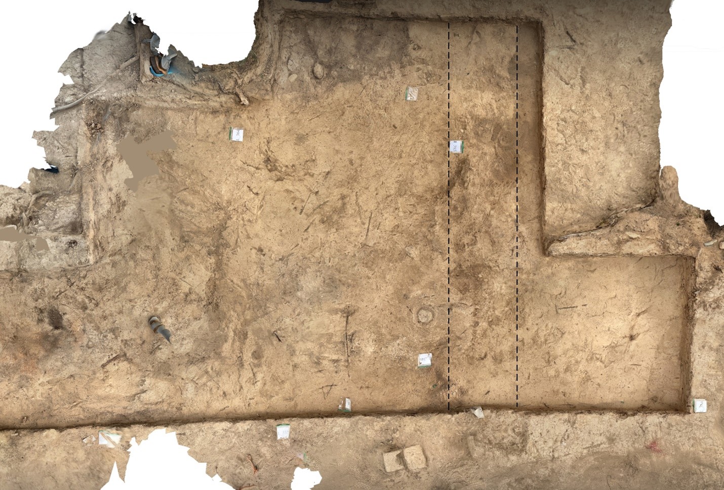
Fig.20. Partial LIDAR scan of L333 (Unit 12). Added black dashed lines indicate the base of a wall (L-365). Note that the circular feature is the lid of a wine khum (L346). Top of the photo is bearing N14°W (C.A. Stewart). |
During the 2023 IB Season, excavators were able to further define the North Annex, but not identify its exact form (either as a building or courtyard). Remains of a wall (L-365) were uncovered and it stood in a north-south direction and, presumably, continued and joined with the chapel (see fig.20). The team’s field interpretation was that this wall served as a step or base for an elevated platform to the north of the chapel’s easternmost room; as such, this platform would have functioned as a courtyard. This wall, evidently, was the lower part of the wall (L-254) found in 2020. Against this wall excavations uncovered a large lidded vessel (khum) that was buried into the floor (at the west side of the wall). This opens up the possible interpretation that this wall (L-254/L-365) served as the eastern limit of a roofed chamber adjoined to the north wall of the chapel (see fig.21a). If this chamber included tombs L-257 and L-258, then it can be called both a mausoleum and a martyrium—but until find the north and west walls are found, this attribution remains speculative. If the khum held wine, then the chamber can be identified as a wine cellar and sacristy. What is certain, is that the medieval ground surface (floor) (west of the wall L-254/L-365) was at the same level as the chapel’s floor (nave), and both floors were made with compacted sandy-silt soil and clay. This type of flooring is called “obmoska” by Russian archaeologists—in English, it is best described as a “treated clay floor” which is between 6 and 10 cm thick. Moreover, this floor (surface) was about 28 cm lower than the compacted mudbrick floor to the east of the wall (L-254/L-365).
Artifacts found on the medieval surface of the North Annex (L-333) were consistent with an interpretation of a “floor”. These consisted of courseware and fine ware (glazed) ceramic fragments and animal bones. Butchered animal bones are quite common throughout this site, both within and outside the cemetery burials and the chapel. With that said, one area had a concentration of bone and ash—therefore, it is best described as an ash feature or ashpit, though without significant depth (L-366). The feature was located on the annex floor’s surface and included several animal bones and ceramic sherds, including a fragment of a fine green glazed nozzle belonging to an oil lamp (chirag). Then, about two meters to the west a fragment of a large vessel (base) and a partial skull of an animal (either a goat or sheep) was also on the floor’s surface. These are rather odd bits of rubbish to find in chapel’s annex (presumably, serving as a sacristy) and near a martyrium; so, there are three possible interpretations:
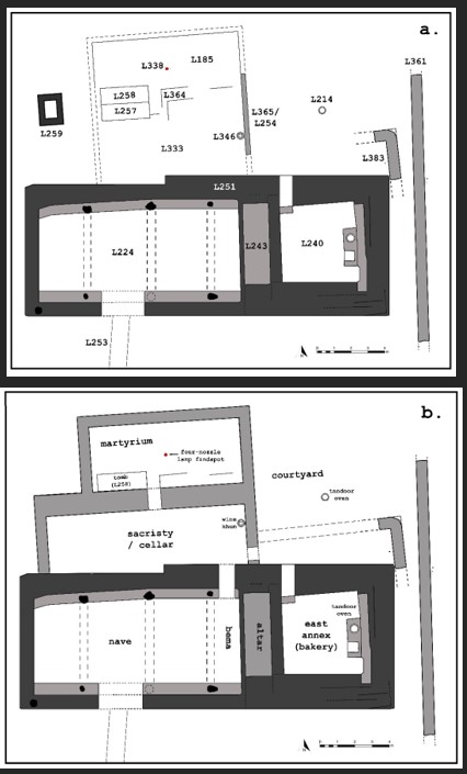
Fig.21. Diagrams of the Funerary Chapel (Unit 12) and North Annex (L333). a. Plan showing the evidence so far uncovered; b. speculative proposal showing a two-chamber construction and interpretation (C.A. Stewart) |
- Funerary meals were frequently prepared within the cemetery and the annex; or
- The chapel and annex were abandoned, and latter squatters prepared a meal here, who were perhaps unaware of the nearby tomb; or
- The chapel and annex were abandoned, and latter squatters dumped their rubbish in this area (which included food waste and broken ceramics).
Among these three theories, the third one is preferable (at this point) since it conforms to the wider context. It is difficult to imagine someone building fire in the middle of a church to cook a meal; likewise, the tomb and the cemetery would have been conspicuous, even after the site had been abandoned. If someone did dump their rubbish here on the floor, after the chapel was abandoned, that would indicate the chapel and its annex were still standing, at least in part. Note that in all soil layers in Unit 12, both on the modern surface and the medieval ground surfaces, similar artifacts (ash, charcoal, sherds, and butchered animal remains) were deposited and mixed within the mudbrick debris; therefore, it seems that the entire site continued to be frequented after abandonment, into the modern period.
Tomb
During the 2023 IB Season, the team excavated L-258 and confirmed that it is indeed a tomb. It was also assumed that the north side of the trench L-364—just to the east of L-258—was also a tomb, but it could not be verified because it is partially under a tree. Tomb L-258 revealed some interesting features (see fig.22). It was a pit burial with ledges, which was then covered with mudbricks; thus, this construction belongs to IB Type 2A. The soil immediately above the mudbrick cover was very dense, and rather hard to excavate; it consisted of deformed mudbricks—so, it is possible that a mudbrick floor once covered over this tomb (that is, above the tomb’s mudbrick cover); alternatively, the deformed mudbricks were fallen masonry of a martyrium, or both. The tomb’s mudbrick covering was also deformed; nevertheless, it is possible to estimate the brick measurements being approximately 25 x 15 x 10 cm. These bricks were laid flat, with the broadest surface on the ground, and oriented in a north-south manner lengthwise. These bricks were somewhat smaller than those used in the northern part of the cemetery, such as Unit 7.
The male occupant of L-258 was oriented in a west-to-east position with his head (at the west end) slightly propped up. His hands were about 20 cm above his chest, indicating that some organic material was placed between (his hands and chest) as if he had once grasped something; unfortunately, no artifacts were found in this area, despite the collapse of this thoracic cavity indicating a rather large object rested on his chest. He was buried at 596.400 meters above sea level (m. asl), which means that this is one of the deepest graves so far excavated. As such, this may indicate that L-258 is one of the oldest burials at the cemetery; one thing is sure, this tomb is the only grave, so far uncovered, that is closely connected to the chapel. As theorized below, this burial seems to have predated the Funerary Chapel.
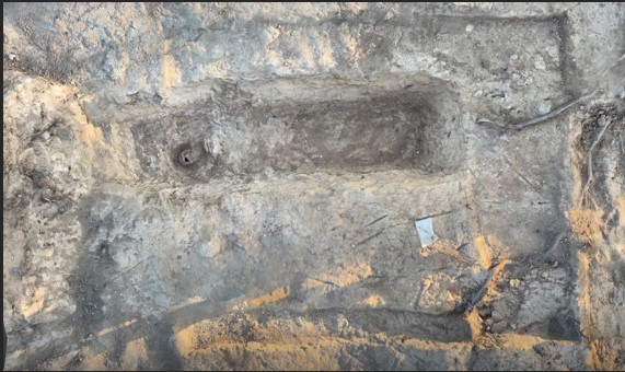
Fig.22. LIDAR scan of Unit 12, L258 (grave) and L257. Top of the photo is north (C.A. Stewart).
Funerary Chapel and Annex Phasing
While the team confirmed that L-258 was a grave, the adjoining feature (L-257) was not able to be investigated. It is assumed it is also a similar tomb since its upper surface is exactly like the deformed mudbrick of L-258; however, it may not be a tomb at all, but rather the remains of a wall as originally interpretated during 2020 Season (see fig.21b). Also a set of mudbricks (L-259) were found to the west of L-257 and L-258; this is shown as the awkward square feature of uncertain function in the plan (see fig.21a). If L-257 is not a tomb, but instead, a wall, then L-259 may simply be the western extent, or corner, where two walls met—one wall that ran north from the chapel and another that separated two chambers (as shown in the diagram, see fig.21b). In this version, the southern chamber would have functioned as a sacristy or wine cellar while the northern chamber served as a martyrium. Note that the two four-nozzle lamps (L-338) were discovered exactly at the center of the hypothetical martyrium. These lamps may have been suspended from the vault above; if so, their find spot should be considered in situ. They fell in place when the walls collapsed. Again, this version better fits what was found nearer the surface of the modern ground level during the 2020 Season; however, this could not be confirmed or rejected with certainty during the 2023 Season. Further excavations, including the removal of the three clusters in this section that are in a straight east-west line, will have to occur in order to confirm, or alter this hypothesis.
The funerary chapel and its surrounding context are complex. Interpreting its layout has been difficult, but it is not an impossible task. Each season has clarified the overall design and function of this space. One problem is that Unit 12 is rather shallow compared to other archaeological sites, such as the Ilibalyk shahristan. Much of the soil above the walls, foundations, and flooring in Unit 12 were covered with deformed mudbrick upon which the field was cultivated by heavy machinery during the Soviet period; moreover, dead roots and living trees has modified the archaeological remains. It is important to remember that the deformed mudbrick once formed the superstructure and vaulting of the chapel. During the 2020 Season, the team reached a level that was assumed to be the original medieval ground surface; however, additional excavations in 2022 and 2023 indicate that there are, at least, two other medieval surfaces—each one can be designated as a construction phase. What is provided below is a tentative interpretation of these phases based on all the evidence so far—and it is, by no means, conclusive.
Phase 1 can be associated with the area and time before the chapel was built. Evidence for this ground surface was found beneath the courtyard (or platform) associated with the level (floor) upon which a tandoor oven was built (L-214). A 14-cm-tall step was constructed within the East Annex (L240) (at the Funerary Chapel’s north wall) and this led to the door’s threshold, forming another 14-cm-tall step that led to the exterior courtyard (see fig.21b). In other words, the courtyard’s mudbrick paving (Phase 2) was about 28 cm above the chapel’s floor (L-240) and the original ground surface (Phase 1). Evidence for Phase 1 was confirmed when parts of the courtyard’s paving was removed (in L-344); underneath was found remains of a round building (L-378) that was constructed on the original ground surface. This round building apparently continues under the chapel’s walls, and its foundations was partially removed by the builders of the chapel’s East Annex (L-240). The exact function of the round structure is unknown; what is certain is that we have evidence of human activity in this area prior to the chapel’s existence.
Both the North Annex and the Funerary Chapel have two anomalies that have been puzzling. First, the orientation of the North Annex (L-333), tomb (L-258), and walls (L-365/L-254, L-383, and L-361) do not align with the Funerary Chapel by four degrees (see figs. 21a and 21b). Second, the Funerary Chapel’s north wall is skewed (also by four degrees) compared to the rest of the building—the other walls are otherwise perfectly aligned with the cardinal points of the compass. Obviously, these two anomalies are related. The best explanation is that the North Annex was built first (during Phase 2) and the Funerary Chapel was constructed later (Phase 3). The Phase-3 Chapel is a more monumental structure, and its precise orientation took precedence; however, to join the newer building to the older structure (North Annex) builders adjusted their design and incorporated the previous mudbrick masonry of the annex, preserving the old alignment (see fig. 23). If this schema is correct then, during Phase 2, the North Annex served as the original “funerary chapel” and was built around the martyrium (tomb L-258), while the tandoor oven (L-214) may have been used for baking Eucharistic bread. One advantage of this interpretation is that the L-214 oven lies near the precise center of a hypothetical square building. It cannot be determined, however, at this point, when this hypothetical Phase 2 building was constructed, and how long it was used as the primary worship space.
At a later date, during Phase 3, a larger Funerary Chapel was constructed to the south. Instead of demolishing the earlier chapel, builders turned it into an ancillary chamber, that served as a sacristy or wine cellar and, clearly, worshippers continued to visit and maintain the martyrium. When a new tandoor was constructed in the East Annex, the L-214 oven was rendered obsolete—whether the oven’s area (i.e. the “courtyard”) was abandoned or maintained is still an open question. What is certain is that the East Annex’s floor led to this elevated “courtyard” indicating that the area still held some significance. Again, it is also important to point out that during the 2020 and 2021 Seasons, our team reached a level of impacted earth that appeared to be the ground surface in the North Annex (L-333); then, during the 2022 and 2023 excavations it was discovered that another occupational surface was 6 to 10 cm lower than this. The best explanation for this is that the lower surface belongs to the Phase 2 occupation, whereas the higher level belongs to Phase 3. Because all the floors (both in the Phase 2 and Phase 3 structures) were covered with ash and charcoal, it seems that these materials were deliberately used to cover the treated clay floors—this helps explains why the floor levels changed between the two phases. In summary, the phases of Unit 12 can be outlined as follows:
Phase 1 – The medieval ground level that shows human activity, including building.
Phase 2 – The construction of the North Annex which housed a tomb, thus serving as a martyrium, and possibly other chambers, which included a tandoor oven. As such it could have functioned as a funerary chapel.
Phase 3 – The Funerary Chapel was constructed to the south of the North Annex, which was repurposed as a sacristy, and the martyrium was maintained. Whether the north tandoor (L-214) continued to be used during this phase, so far, cannot been determined.
It must be reiterated that these suggested phases are still hypothetical. So far the existence of only one wall (L-365) has been confirmed. Therefore, the possibility must continue to be entertained that the North Annex was an open courtyard (and not covered by a roof or a martyrium); if so, the Funerary Chapel could have been built first, that is, before the courtyard and the tomb (L-258) was established. Only with further research and excavation can the relative phasing be clarified, and the original design and function of the North Annex determined.
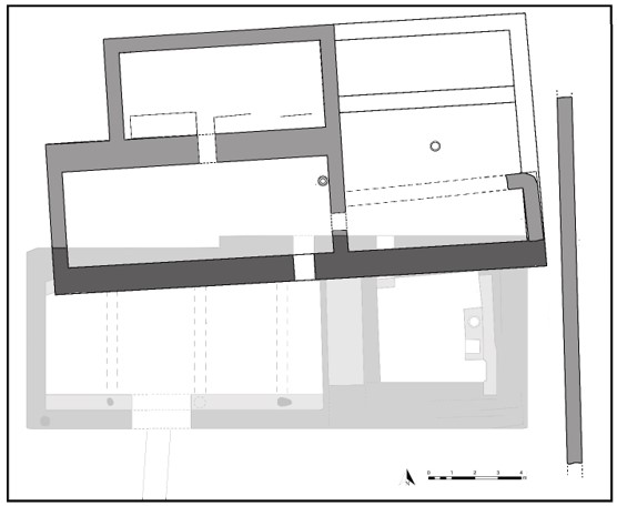
Fig.23. Tentative plan illustrating a hypothetical 2nd-Phase Funerary Chapel and Martyrium, near the top. Faded areas, near the bottom, indicate the later 3rd-Phase Funerary Chapel. White areas are pure conjecture (C.A. Stewart).
Grave Excavation Findings
With the conclusion of the 8th season at Usharal-Ilibalyk, 110 graves in total have now been excavated in the Christian cemetery. Previous reports and subsequent publications (see bibliography) have clearly established that the cemetery represents a homogenous religio-cultural link with the medieval Church of the East during the Mongol period. No other cultural material or burial type has been revealed that would suggest any other religious expression in the cemetery to date. Both cultural material and radiocarbon dating has clearly established the use of the cemetery ranging approximately 1200-1350 AD. This season’s excavations not only continued to affirm these conclusions, but also provided more insight into the Christian community’s sub-cultures as well as with a possible “founder” or “saint” within the community.
This section of the report will provide a summary of some key grave excavations from this season and what the grave constructions; accompanying grave goods; and provenance may tell us in relation to these findings. The conclusions in this section should be considered preliminary and more research, particularly in comparison with other archaeological discoveries in the region and greater Christendom from this period, is certainly warranted.
Locus 258: Possible Founder of the Christian Community
The locus for this adult grave was discovered in 2020 (see 2020 Field Report, pp. 28, 124) and was described as a collection of gray mudbricks, extending in a 230 x 70 cm east-west alignment, with other bricks on both the east and west sides. However, the appearance of these bricks as well as a parallel feature immediately adjacent and parallel with L-258 (designated L-257), with a reddish-pink tint to the soil, caused excavators at that time to interpret these features as something other than graves. In fact, these loci were part of the excavation plan objective for the following 2021 season. That subsequent investigation led to a firmer conclusion that these two features were certainly not graves, but, as the 2021 report stated:
“The current interpretation is that these features marked a delineation between the cemetery to the north and the funerary chapel’s territory. They may have been part of a gate construction and/or entryway into the cemetery itself in which the deceased was escorted from the chapel to the grave” (2021 Field Report, p. 96).
Were it not for a settling of the soil enhanced by the geotextile—that covered these features as a part of the normal protection of the funerary chapel site which revealed mudbricks extending over the entirety of L-258— this grave might have gone unnoticed and ignored. Once, however, it was realized that these bricks covered a large grave approximately 6 meters north and parallel with the funerary chapel, interest returned examine this feature.
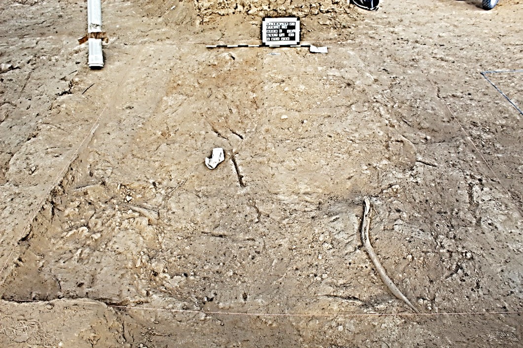
Fig. 24. Loci 257 (L) and L-258 (R) following geotextile removal and clearing of loose soil.
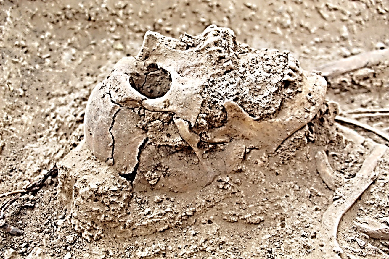
Fig.25. Profile of skull (L-258) with prominent nasal bone.
As the locus description for L-258 details above, this feature was, in fact, a grave, which contained the remains of an Old Adult (50+ yrs.) male of significant size (i.e. height approximately 190 cm as extended in the grave). In fact, preliminary investigation of his remains shows that he was the largest individual discovered so far in the cemetery. In addition, as his skull features indicate, his prominent nasal bone and large mandible seem quite robust and distinct in relation to the other excavated skeletons. His tall facial features stand in contrast to many of the adult facial features of those within the rest of the cemetery, particularly within U-15 and U-17, which seem more East Asian in appearance, with flat, broad zygomatic bones and broader nasal cavities. The dentition for the remains in L-258 was highly worn, indicating this person’s advanced age at time of death and/or overall health, therefore, an examination of the incisors on these remains is problematic which might reveal Asian or Caucasian ethnicity (White, 400-410). Shovel-shaped incisors have been found on many of the skeletons throughout the cemetery (2019 Field Report, 246-247). While physique does not necessarily set others apart for leadership or status, this individual's height would have been prominent and remarkable. In other words, the person buried in L-258 would have been distinguished and had a commanding presence in comparison to others in the Christian 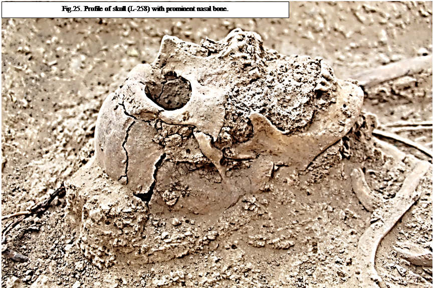
community at Ilibalyk.
Yet, the large stature of this person aside, this grave is unique in several other features. Most prominent is the grave’s location. This grave is nearest to the funerary chapel in comparison to any other within the entire cemetery. No graves have been discovered within the nave or possible altar area to date. No graves have been revealed to the south of the chapel, and the nearest remains to the chapel’s west were adult-sized bones in Unit 10, L-210, which lies 9.2 m from the chapel’s west wall (see 2019 Field Report, pp. 113-114). The excavations of the section due north of the chapel—specifically L-333 and its accompanying loci—along with excavations north of L-258 in L-185, strongly suggest that L-258 was within either a stand-alone mausoleum or an attached martyrium, which served as a northern wing to the chapel itself. If the adjacent Locus 257 is also an adult grave, and if L-379 (currently identified as a gray-colored soil feature with mudbricks in an east-to-west line, yet obstructed by a tree) which lies due west of L-257 and L-258 is found to be a grave, then these tombs are set apart from the rest of the cemetery and within a structure, whether mausoleum or martyrium, considered special by the community.
While exact height cannot be determined by simple measurements of the skeletal remains as interred, no known height formulation has been done for osteological remains in Central Asia. Such a process involves a careful measurement of the appendicular bones followed by a specific mathematical formula. It is this team’s hope to eventually discover or compile such a formula that would provide a more accurate rendering of height and stature for these and other cemeteries in the region. To date, L-257 at 190 cm is the largest adult skeleton measured in situ, the next largest is L-320 (U-16) excavated in 2022 at 185 cm, but all the other adults excavated to date do not exceed 180 cm. While slight variations in burial positions and decomposition render exact height measurements impossible, this rough estimate can certainly prove accurate enough for general comparisons. Currently, the average height for adult skeletons (as interred in the grave) would be 167.6 cm (5’6’’) whereas the body in L-258 his 190 cm (6’3”) would have towered over most of the interred of the Ilibalyk cemetery.
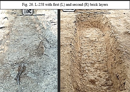
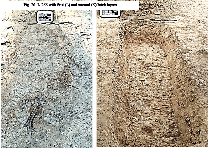
A third factor is the grave’s construction. Excavations revealed two layers of mudbrick across the width of the grave. This is a completely unique characteristic of any grave to date. This has caused the excavation team to identify this as a new variation grave type, specifically Type 2F. The Type 2 graves comprise the majority of graves within the cemetery which utilize bricks in both the lining and covering of the remains in various ways (see 2019 Field Report, pp. 230-237 and 2022 Field Report 129-135). In this case, the double brick layer has an upper layer— which may have protruded through the martyrium floor or even been a part of it followed by a layer of soil, then another layer of bricks. This may indicate that the tomb was first dug during an early phase of Christianity’s presence in Ilibalyk, and with the martyrium built later, or as time passed, the floor of the martyrium accumulated soil or ash over the decades, leading to the addition of soil followed by placement of the upper layer of bricks. It is also possible that the martyrium or mausoleum preceded the construction of the funerary chapel. At the moment, the relationship between this grave and chapel, in terms of stratigraphic phasing, has not been established; however, the top surface of the grave is approximately level to the floor of the chapel.
A fourth factor is the grave’s depth. The remains of the interred of L-258 had a skull level of 596.693 m. asl. This is the fifth deepest skull level of all the excavated remains, with the deepest (L-211) only exceeding this grave’s skull depth by 38 cm. Two of the other four graves exceeding L-258 in depth are those in Unit 3 (L-211, L-190), which is only 15.1 m away to the east-northeast. Our current hypothesis is that the oldest graves of the cemetery are those on the southern area, with some variation, perhaps pertaining to family plot placement and other factors. If so, then it might be expected that early 13th century graves are slightly deeper on average than those further north. Other factors must also be considered if our hypothesis concerning the cemetery being on an incline or hill is correct (see 2022 Field Report, pp. 128-129). Yet, the depth of the remains of L-258, given the other contextual factors, suggests an earlier interment compared to other burials, and pronounced social (and religious) status afforded to the person interred.
A fifth factor was the unique position of the body’s arms, in this case it seems clear that a large object was placed on the body’s chest with the arms placed around the object, as if embracing it. Excavators discovered that the body’s left arm, specifically the ulna and radius, extended upward along a slope at approximately a 20-degree angle with the left hand resting on soil that extended 20 cm above the skeleton. The right hand, which was near the waist, was above the pelvis by 7 cm and not intermingled with the thoracic vertebrae, but the bones of the right hand appeared to lay over a rounded object. No material culture or artifact was detected in the soil fill of the chest or under the arms, thus, whatever was placed there had deteriorated, suggesting it was completely organic (i.e. containing nothing metallic, ceramic, or osteological). The object would necessarily have some mass and weight; first, because it supported the original weight of the arms at time of burial and, second, because it was heavy enough that eventually the entire left side of the rib cage collapsed.
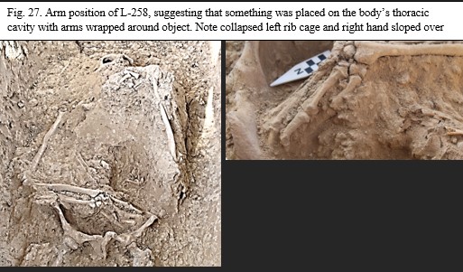
Grave goods, like most medieval Christian burials around the world, rarely extend beyond personal items, such as jewelry. Units 15 and 17 have also revealed some interments having status items as part of the burial (i.e. the boqtag of L-290; scissors of L-291 and L-317; weaponry of L-373; coins in mouth of L-314 and L-317). The remainder of the graves contain a few pieces of personal jewelry, but only in a few burials. Therefore, the inclusion of a large object in which the departed is embracing it, while buried within a probable martyrium or mausoleum, communicates something both about the object and the person buried with it. Further soil analysis from the samples taken from this grave may determine what was placed on the chest of the person in L-258. If not, then this question may never be answered; nevertheless, a large object placed within the grave is beyond question, which again indicates status and uniqueness. Given the value of textiles in this region and, in particular, the vestments (urara and sudhra) in the Syriac tradition, it is possible that a folded garment had been placed in this location.
A final factor to consider related to this grave’s status and significance are the nearby artifacts that were discovered nearby, specifically the two 4-nozzle lamps and chalice base found just 330 cm from the grave. As mentioned in the Special Cultural Material Section, one of these lamps was intended to hang suspended by a chain with a metal cross connector either from the ceiling or lamppost. The other probably sat on a floor stand or within a niche in the wall of the room. Examples of such suspended lamps have been documented in similar sacred tombs in Armenia. It is possible that a mausoleum (or martyrium) had covered this area, including this grave; at the moment this is a working hypothesis.
While many questions remain unresolved, this grave was a person of high religious status to the community based on the above factors. Yet, there is still one potential link that will require further investigation. If the locus adjacent and due south of L-258, specifically L-257, is also a grave (which will have to be excavated as priority for a future season), then this raises the level of significance even further. Nowhere else in the cemetery have two tombs been found parallel and right next to each other. If L-257 is a grave, then this section of the martyrium had at least two graves contained within this confined space, designated with special lighting, which cast significance on the two possibly interred within.
If this supposition is subsequently verified, then it is reasonable to assume that such a double-grave could have been marked with a single kayrak (gravestone). Such a stone was discovered near this location by approximately 10.5 m due north of L-258 during the 2017 excavations. The discovery occurred while the modern topsoil layer was being initially removed in Area C by a mechanical excavator. So, the exact findspot for this stone was only designated after it was seen in the churned soil of the tractor, not directly in situ. The direction of the tractor during topsoil removal and the designated findspot is in a virtual straight path due north of L-257 and L-258 as the tractor removed the soil in a north-south direction within Area C in 2017.
This kayrak (IB 17-IV-С-7) is now labeled the “Yošmid Stone,” a large, round green stone with a written inscription in Old Turkic (See 2017 Field Report, p. 146). In Old Turkic the stone reads:
Latin letter transcription: Baršabbā Qučning qabrāsi. Yošmid kāhnāning qabrāsi.
English translation: The grave of Baršabbā Quč. The grave of Yošmid the priest.
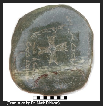
![]()
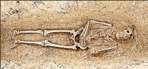
![]()
The original hypothesis for this stone is that it marked the double grave of potential plague victims, or of two adults who died simultaneously and were thus interred together. Such graves have been noted in the Kara Jigach cemetery near Bishkek, which has recently been verified as “ground zero” for Yersinia pestis, the plague bacteria responsible for the pandemic known as the Black Death that struck medieval Europe in the 1340s (see Spyrou; Slavin 2020).
However, with this latest discovery of the potential double grave within the martyrium, a revised interpretation must be considered. The large green Yošmid Stone commemorates a priest, Yošmid, and Barshabba Quč. While Yošmid’s role as clergy was an important office for the Christian community, the name Baršabbā Quč is also found on the meter-long stone discovered in 2014 which initiated the entire Ilibalyk excavation project. This stone, the largest of any discovered throughout the Church of the East gravestone corpus in all Central Asia, mentions a Baršabbā Quč’а as the grandfather for the interred, a “Petros the priest.” A slight variation in the spelling between “Quč” and Quč’a is noted on the stones, yet, such spelling variations are common throughout the Zhetisu (Semirechye) Corpus of stones. The double moniker of a Syriac name in combination with a Turkic name is certainly not unusual. name Baršabbā is unique enough, however, to suggest that the name on these two stones, within this same community, may refer to the same individual—one designating Baršabba Quč’s grave shared with Yošmid, the other identifying him with his grandson, Petros.
Baršabba’s second name, Quč, means either “ram” or “strength” and is a Turkic name, thus this name is a Syriac-Turkic combination. The double name Baršabba Mumin was found on a kayrak from the southern Zhetisu region. Another example of a combined Syriac (or biblical) name with a Turkic name would be Johann Tegin (see Zhumagulov, 27-33). The name Baršabba in Church of the East contexts, particularly in Central Asia comes from the original Mar Baršabba, attributed as a founding missionary who brought Christianity to the far reaches of the Sassanid Persian Empire, specifically the city of Merv, in the late 4th or early 5th century. (Baumer 2016, 72).
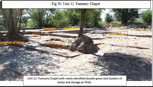
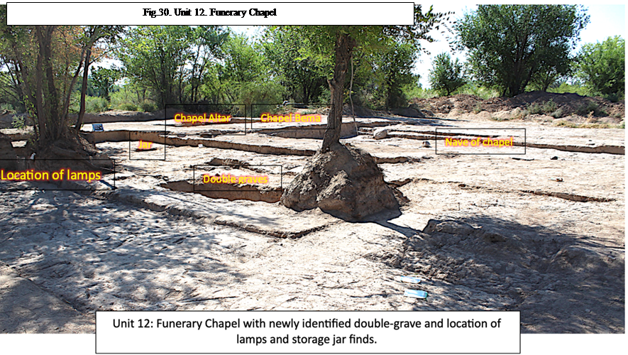
This mention of a third generation on a gravestone appears to be unique to Ilibalyk among the Zhetisu (Semirechye) Corpus. Other stones in the Chuy Valley mention fathers in conjunction with the deceased, but as far as we know, no grandfathers. If Baršabbā preceded Petros in death, then this may indicate that the former was a person of great significance and importance remembered by the Christians of Ilibalyk. Perhaps this man had established the Christian community here as a missionary; alternatively, he may have been sent here later to revitalize the local church when religious tolerance was promulgated by the Qarakhitai, in the late 12th century, or during the so-called Pax Mongolica that emerged in the mid-13th century. late 12th century or the Pax Mongolia the emerged in the mid-13th century.
The weight of the accumulating archaeological evidence, and historical knowledge of the spread of Syriac Christianity, indicates that the above interpretation is beyond mere speculation--but, by no means, is it certain. Indeed, if a second grave is revealed in L-257, then this hypothesis is the best interpretation. Regardless, the discovery of the skeletal remains in L-258 is still one that was considered important to the Christian community based on the abovementioned factors and excavations within this special area should continue to see if the evidence supports this idea.
Locus 373: Turko-Mongol “Warrior”
Within the central section of the 23-meter-long excavation trench, Unit 17, a grave containing a Young Adult (20-35 yrs.) male was revealed. This grave proved significant due to the discovery of various weapons as grave goods, including 2 arrowhead and/or spearheads and a possible dagger (Ib_23_C_IV_373_I006). More than 50 various other iron fragments were discovered throughout the grave, likely as part of his clothing, specifically three 6-petal shaped medallions (Ib_23_C_IV_373_I002), which may have been attached to his clothing or decorative pieces for a quiver or scabbard. Other than the weapon fragments discovered next to the left femur, most of rest were in the soil fill in a vertical layer on the south side of the skull which seem to be part of headgear comprised mostly of organic, thus degradable material, from which no remnants were discovered. Most of these other fragments, due to their heavy corrosion, were unidentifiable, however, the medallions do suggest a decorative function. While these accoutrements do not suggest some type of full battle armor, they are suggestive of costuming of what we term a “warrior” or someone identifying with a military purpose or that of a hunter.
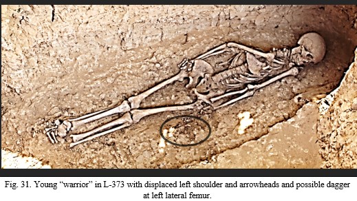
This is the first time such a grave with weaponry, specifically iron arrowheads, has been discovered in a grave. The only exception is grave L-290 (10.4 m to the northeast), which is the female burial of high status containing a boqtag headdress, in U-15, who had a possible dagger placed between her knees and another possible dagger at her left lateral tibia—as identified in the Crimea Island Scientific Restoration Laboratory under the direction of Krym Altynbekov in Almaty, Kazakhstan via x-ray in 2023, (report forthcoming). Such inclusion of weaponry in a grave has been found in other graves from the Mongol era, specifically nomadic graves from the 12th-13th century in Tavantolgoi in Mongolia and Buryatia regions of Russia (Ulziibayar 2022, 230; Assev, 198). The graves in those locations have not been identified as specifically Christian, though those from the Golden Horde areas, specifically on the territory of today’s western Kazakhstan and southern Russia, come from a mixed population of multiple religious expressions during that period and contain weapons such a arrowheads as well as other items such as scissors and other household goods within the tombs (Koltsov, 78-79). Further research for comparative purposes is warranted, though, as Koltsov has mentioned, finding specifically nomadic cemeteries from the Mongol era have rarely occurred.
Examination of the remains while in the field provided further evidence of a “warrior/hunter” connection. Specifically, the question of the way the right shoulder, specifically the way the scapula and humerus bones were displaced medially toward and rested within the thoracic region (see L-373 locus description). While such a position may be explained from roots (and this grave was under an existing tree) or other shifting of the soil within the grave, the presence of an arrowhead at the location where the right shoulder would have rested together with a possible pre-mortem fracture of the left femur, suggests something more violent may have occurred that could even explain death. Age at time of death does not appear to exceed 23 years, based on the lack of complete fusion of the sacrum. In addition, preliminary examination of the pelvis, and specifically the acetabulum joint sockets, may indicate horseback riding. (Trautmann et al.; Berthon, 117-126).If so, this young man, whose shovel-shaped incisors indicate Asian ethnicity markers suggests someone who lived actively as a warrior/hunter that may have met an unexpected, early death.
Church of the East warrior and military connections are not at odds with one another. Nestorians with military connections are well-known, with the most notorious being Nayan, a Mongolian royal prince and possible great-grandson of Chinghis Khan’s brother, ruling several appanages of the Empire and with strong connections to Kaidu, the de-facto ruler of the Chagatai Ulus which included the domains of Ilibalyk. Nayan eventually rebelled against Kublai Khan in reaction to what Nayan feared as Kublai’s rapid Sinicization of the Empire. According to Marco Polo, Nayan fought under the banner of the cross. His campaign of rebellion failed after his defeat and execution in 1287 (Stewart 2022:160: 6; Yule-Cordier 1993: I.339; Toepel 2009:282).
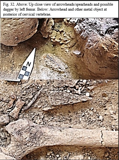
The honoring of military saints seems to both pre-date and coincide with Turko-Mongolian Christian military concepts. Illibalyk excavation team member, Dr. Charles A. Stewart, has argued in an upcoming publication that the Syriac tradition honored common military saints, such as George, Sergius, Bacchus, and Theodorus (Tiron) (Stewart, 2024). One such warrior saint in the Syriac tradition is Mar Qardagh who by 350 AD is described as wearing a cross around his neck before entering battle. Stewart believes this is the earliest account of Christians wearing cross pendants on necklaces (Walker 2006: 50, 52).
Barthold in his publications refers to the Turkic Chigil tribe with their own capital located south of Lake Issykul, who served as a core of the Islamic Qarakhanid army, even though the Chigil had known Nestorian connections (Barthold 1928: 317; 1963: 88). More closely geographically within the Zhetisu region itself is the Naiman prince, Küchlüg, who was received by the Qarakhitai of Balasagun (in southern Zhetisu) who was initially identified with Christianity, whose religion was traditionally Christian from the 11th century onwards, but who appears to have converted to Buddhism as part of a contractual alliance through marriage. This probably was a political move to gain Qarakhtian support against Chinggis and the Mongols, who later captured and executed Küchlüg ending his short-lived rule (Tang 2009: 257-26).
All this historical connection is meant to demonstrate that the Central Asian Nestorian tradition having a military class would not have been unusual at Ilibalyk. In fact, the discovery of the remains and accompanying grave goods in L-373 demonstrate that a warrior class was part of the Christian community in this region.
Locus 317: Wood-lined tomb with Scissors and Coin
As detailed in the loci descriptions, L-317, contained a Middle Adult (35-50 yrs.) female interred within a very large wood-lined tomb and metal scissors at the south side of her head. Additionally, a coin was found to be inserted in this woman’s mouth at burial. This tomb—a variation of the Type 3 tomb (in this case given a new designation, Type 3B)—was more elaborate than a wooden cover (as revealed in L-131 and L-291) but was a structure with vertically-placed support beams that included wood beams lining the contour of the grave’s walls on the west, south, and east sides. While no wood was discovered under the remains (which would have possibly indicated a coffin), the body was probably placed inside the wooden chamber from the north once the structure was completed. Then, mudbricks were placed on the wooden roof and the chamber enclosed with mudbrick on the northside, followed by filling the interment chamber with soil.
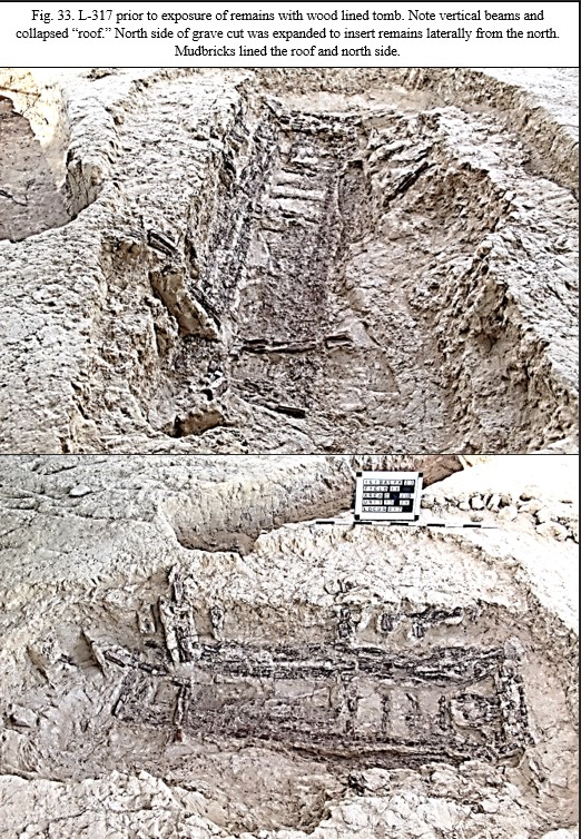
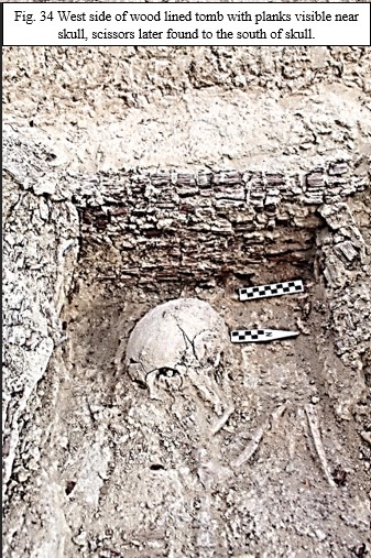
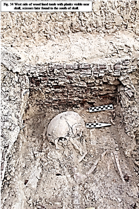
Such a structure with this size and amount of wood has never been found before within the Ilibalyk Christian cemetery. It speaks not only to the expense needed to construct such a tomb, but also to the elite status of the person buried. This status is further enhanced by the presence of the scissors, which have been found in L-291, L-290, and this tomb respectively. Each of these graves are adjacent to one another and lay in a row extending north-to-south.
The inclusion of scissors within graves have been found in Mongolian tombs, both male and female, from the 12th-13th centuries in locations around the former empire (Kradin 17-43). Wooden covers and wooden lined tombs have also been found in these contexts (Ulziibayar 2010, 226-228). Given that these tombs are immediately next to one another and, with two of the graves having either this wooden structure or wooden cover, and all three contain scissors, it is possible to confidently assert that these tombs in this section of U-15 are unique in comparison to the other sections of the cemetery. They not only indicate wealth and status, but possibly a sub-culture among the Christians at Ilibalyk, specifically a nomadic Turko-Mongolian cultural identity.
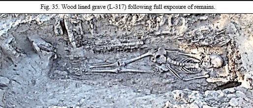
Admittedly more research is needed related to these burials specifically because they included three women with a Turko-Mongol heritage. Not only because this suggests a family group buried together in the cemetery, but also because Christian women of status and influence are well known in the history of the Mongol empire. It was the pattern for Mongolian rulers to marry Keriet and Naiman women following those tribe’s absorption into the Empire in the first half of the 13th century. As Mongol historian Jack Weatherford has observed:
Although he [Chinggis] had killed most of the [Keriat] aristocratic men who had fought against him, he recognized something unique and useful in their women. The Naiman and Kereyid women were some of the most sophisticated and cosmopolitan women he had encountered. They were very much women of the steppe—riding horses, shooting arrows, drinking fermented mare’s milk, and participating fully in political life—but their Christian faith gave them knowledge of a world beyond the steppe and connected them to some of the most important centers of civilization. …although no Mongol man of that era was known to have converted to Christianity, having a Christian wife became a popular practice over the next generation. (Weatherford, 2010).
The natural progression of thought related not only to these three burials, but also in combination with the “warrior” grave (L-373) 10.4 m to the southwest, is whether these graves and possibly this section of the cemetery represent Turko-Mongolian nomads, even perhaps Naiman or Kereit burials. Teeth samples taken from each of these graves can potentially be submitted to genetic testing. Kazakh scientists involved in genetic studies have recently published findings specifically related to specific tribes and the three traditional zhuzes, or hordes (See Khussainova; Ashirbekov). Samples are continually collected from the modern local population which could be used for comparative purposes with that portion of the Kazakh population who claim Naiman and Kerei descent. If a genetic link is discovered, then this would mean that the first archaeological evidence of Naiman or Kerait Christians has been detected at Usharal-Ilibalyk. This would support and confirm the known textual evidence already in the historical accounts. It may also demonstrate that the ethnic composition of the Christian community at Ilibalyk was a diverse combination of settled Turko-Persian dwellers in the city and nomadic Turko-Mongols from the surrounding areas.
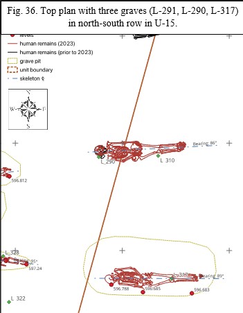
It is important to emphasize that this is still a working hypothesis, but the recent discoveries of these graves within U-15 and U-17 provides compelling evidence of Turko-Mongolian culture that is distinct from those buried in the western side of the cemetery. A boqtag headdress (L-290), scissors, (L-291, L-290, L-317) and coins in mouths (L-314, L-317) have only been discovered within U-15 and have distinctively Mongolian characteristics with analogies throughout the region in both grave good content as well as time period (11th-13th centuries). This is a distinctly Turko-Mongolian section within the Christian cemetery.
is important to emphasize that this is still a working hypothesis, but the recent discoveries of these graves within U-15 and U-17 provides compelling evidence of Turko-Mongolian culture that is distinct from those buried in the western side of the cemetery. A boqtag headdress (L-290), scissors, (L-291, L-290, L-317) and coins in mouths (L-314, L-317) have only been discovered within U-15 and have distinctively Mongolian characteristics with analogies throughout the region in both grave good content as well as time period (11th-13th centuries). This is a distinctly Turko-Mongolian section within the Christian cemetery.
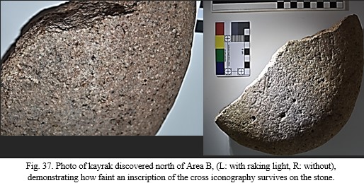
This kayrak (gravestone) was discovered by chance approximately 20-30 m north of Area B within Field IV. The exact location of the findspot was not taken since the discovery occurred on the very last day of excavation during backfilling operations and the geodesic equipment was already removed from the site.
It is a flat, disc-shaped piece of pinkish-white granite with a leveled surface on both sides and a rounded edge. The stone was fragmented and only half of it survives. The remaining portion measures 12.3 x 11.3 cm and is 5.4 cm thick. On the side of the stone that is fractured, a very faint partial cross inscription is visible. It is evident that when the stone existed in its entirety, a whole cross inscription dominated the center of the stone. This surviving section has no other inscriptions or engravings and without the aid of raking light, the inscription is barely noticeable.
The two surviving arms of the cross flared outward from the missing center of the stone. The longest surviving crossbar is 5 cm long and flares outward from 4 cm wide and terminates in a point, or diamond shape. The other crossbar is 3.8 cm long and terminates on its flared end with a vertical straight line expanding from 2.9 cm to 3 cm wide. The engraver used a method of thin contour dot punching by using a chisel to incise an outline of a cross on the surface of the stone. First, the pointed tip of the chisel was used to mark an outline of the cross as peck marks; afterwards, the marks were joined together by carving the spaces in between, and these eventually became incised lines. The width of these chiseled lines is 0.2 cm.
This is only the second time that cross iconography utilizing this method of chiseling has been discovered on the kayraks at Ilibalyk, since almost all the stones discovered prior to this one use a variety of sunken relief techniques, whereas, the contour dot method seems to predominate the cross iconography on the stones from southern Zhetisu in the Chuy Valley. The only other kayrak with contour dot punching was found in L-128 in U-7A (Ib_19_C_IV_128_I004), which also was only a partial stone, may have been in association with an adult grave, yet 2 sub-adult graves were close to the same location. Because this latter stone was also only a fragment, only one crossbar was visible on the surviving portion of the stone. (See 2019 Field Report, pp. 223-224).
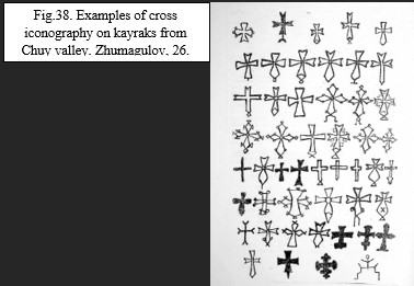
Because only two of the four crossbars are visible from the current stone in question, it is difficult to determine the orientation of the cross as to which is the horizontal crossbar, and which is the vertical. However, based on the cross iconography of kayraks in southern Zhetisu (Chuy Valley, Kyrgyzstan), it is probable that the cross arm with the pointed end would have been oriented downward. If so, then the other crossbar would have been on the right side. If this interpretation is correct, then the probable size of the entire cross may have been 9 x 6 cm. It may also be possible that a second cross was inscribed within the first since a parallel line is visible about 1.5 cm to the left (according to the interpreted orientation) of the right crossbar. Also, a chisel line may be visible 2 cm above the pointed base of the cross. This cross-within-a cross motif, while rare, has been noted on the Chuy Valley stones, specifically a kayrak in the collection of the National Historical Museum of Uzbekistan in Tashkent
(Dickens, 2020, 51-53, 363, Fig. 2-4).
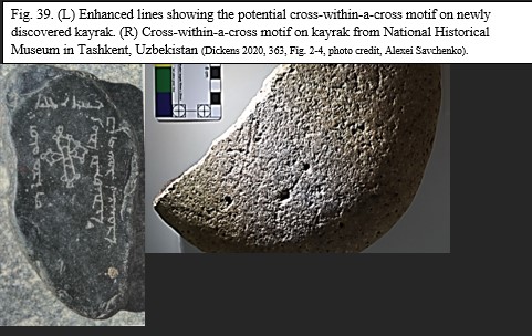
Regardless of whether the cross-within-a-cross motif is found on this stone from Ilibalyk, utilization of the contour dot technique and possible iconographic similarities demonstrate further connection between the Christian communities of southern and northern Zhetisu.
Metal Finds
Grave goods within L-317
Scissors (Ib_23_C_IV_317_I004)
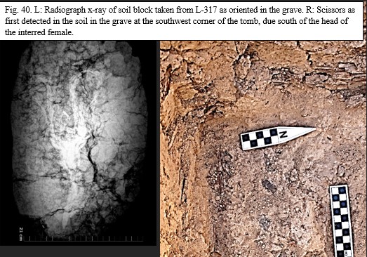
During excavations south of the skull of the female in L-317, metal fragments were discovered by excavators. Initially, due to the large amount of wood in the soil fill, it was surmised that another boqtag (boqta) headdress had been discovered, especially because this tomb was located adjacent to and due south of L-290, a tomb discovered in 2021 and extracted as a block in 2022 with subsequent laboratory investigations, who did have a boqtag headdress in almost the exact same location relative to the skull (see 2021 Field Report,pp. 48-51; 2022 Field Report, pp. 63-68). It was then decided that this artifact would be extracted as a block and removed for later investigation in a laboratory.
Following the extraction and procedural processing of the remains, the soil was isolated by creating an oval-shaped boundary to carefully incorporate the entire artifact. The soil was lowered by approximately 10-15 cm around the artifact, creating boundaries 32 EW x 21 NS cm. The soil was then undercut utilizing a sharp trowel. A flat plastic cover was then inserted within the cut, the soil was wrapped in plastic cellophane followed by industrial strength duct tape and extracted from the tomb.
The following month, in August 2023, this soil block was taken to the Crimea Island Scientific Restoration Laboratory under the direction of Krym Altenbekov in Almaty, Kazakhstan. The soil block was scanned by portable x-ray equipment and the resulting radiograph, revealed a pair of metal (iron) scissors. According to the scissor’s orientation in the tomb, they were placed on the south side of the head with the blade pointing toward the feet, or east.
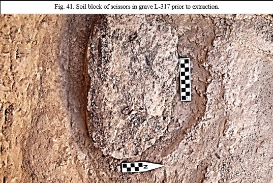
The scissors measured 310 mm long from the furthest point of the northside handle to the tip of the blade and 190 mm wide at the maximum width of the loop handles. The loops were not uniform in size, with the inner loop of the northside handle measuring 60 mm wide and 70 mm long and the inner loop of the southside handle measuring 30 mm wide and 70 mm long. The rope-like handles, which appeared to be made of one piece of curved iron, were about 10 mm in circumference, though this is not exact due to the corrosion of the metal as seen in the radiograph. The inner side of the handles formed vertical u-shape toward the tang leading to the pivot point, though no tang screw was visible. The area of the tang was a sub-triangular shape measuring 50 x 30 mm. While the exact attachment point from the tang to the blade is not visible, the blade appears to measure approximately 110 mm long and 25 mm wide. The blade appears to have corroded in the soil with a slight shift in the soil to the south.
The radiograph seems to show additional metal lying underneath the scissors; however, this is not conclusive. An attempt to expose the scissors within the soil matrix failed, with the iron metal’s integrity so poor that it fragmented into hundreds of slivers of metal no larger than 3-4 cm.
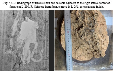
As mentioned in the Grave Excavation Findings above, these scissors are part of medieval Mongolian burial practices and indicative of elite female burials. This is the third pair of scissors discovered in tombs at Ilibalyk (L-291, L-290, L-317) and they were all found in adjacent graves in a successive row proceeding north-to-south. The first pair, discovered during excavations in L-291 on the north side of the females head, were also removed as a block and examined in lab conditions, though not subject to x-ray. At that time and based on that investigation, it was uncertain as to the item or its function, and the 2022 Field report even speculated that the metal object might have been the frame to headgear (pp.156-160). However, subsequent research has shown the practice of including scissors existed and has been discovered in various locations. Both the scissors in L-291 and L-317 are now known to have been of similar composition and size. Additionally, during laboratory examination at the Crimea Island Scientific Restoration Laboratory, scissors were discovered, first through x-ray, and then subsequent excavation on the south side, or at the lateral right femur, of the female burial in L-290, which also contained several other grave goods including a boqtag headdress, a dagger, and a small wooden box containing a silver bracelet and ring. The scissors, in this case, were much smaller in size (exact measurements still pending) and the small treasure box had been placed on top of the scissors. As mentioned above, scissors in graves have been found in burials in Mongolian contexts from the medieval period both in Golden Horde areas as well as within Mongolia proper. This provides further confirm the Turko-Mongolian affiliations of those interred in this section of the Christian cemetery, specifically U-15.
Coin (Ib_23_С_IV_317_I003)
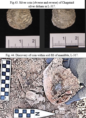
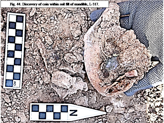
While completing removal of the female skeletal remains of L-317, excavators discovered this silver dirham of the Chagatai ulus in the mandible. It was covered with a green patina and the corrosion from the patina had discolored both the hyoid bone and the base of the mandible’s body. Once the coin was removed from the soil matrix of the mandible, it was eventually cleaned using a soft brush and water. At that point, the green patina was cleared but revealed a heavy, black corrosion. It was originally suspected that the coin would provide no further information, however, after subject to further processing, this black corrosion was fully removed revealing the silver dirham. Both the obverse and reverse revealed some of the imprint, though it was still poorly preserved with many pock marks and indentations. The borders of the coin were quite uneven and rough. Unfortunately, the poor state of preservation has prevented numismatic experts from deciphering a date, however, its size and what remains of the legend allows it to be placed within the Chagataid era (1227-1363 AD), specifically the second half of the 13th century.
The first coin discovered in situ in Area C was found in 2021 in U-13, the excavation unit due south of the funerary chapel in a shallow midden. This coin dated to 689 AH or 1289 AD. The second coin was found in L-314, also in the mouth of an interred female, dating to AH 686 or 1287 AD (see 2022 Report, 140-141). These finds provide clear evidence that the graves in this section of the cemetery were from the latter half of the 13th century, specifically prior to the 14th century as, according to numismatic expert P.K. Petrov, these dirhams were in circulation for only about 10 years. It also likely affirms that the funerary chapel was functioning at this same time.
Even though the coin in L-317 failed to provide a specific date, its location, less than 3 m to the northeast of L-314, thus, it is probable that these interments occurred close in time to one another. If the current theory holds that tombs closer in proximity to the chapel are earlier in chronology, then L-317 also dates around or after 1287 AD and probably before 1300 AD since this dirham is similar to the dateable ones. Another possibility remains, however, that these graves were part of a family plot. If this was so, then the proximity burial idea may be less tenable.
As mentioned in the 2022 report, coins placed in the mouth of the dead date to ancient Greece, in which the coin, or obol (Gr. ὀβολός) for a fare to pay Charon, the ferryman, across the river separating the living from the underworld (Warner 2020, 74). Perhaps due to Alexander the Great’s conquests across Persia and through Central Asia, this Hellenistic practice may have reached parts of Persia. Later evidence suggests that the practice reached China via Byzantine contact (Ying, 1), with also instances in Jewish and Nabatean contexts (Altman, 79-82). Medieval Christian contexts in the West re-interpreted the practice, associating it with the final Eucharist, known as the viaticum, Latin, meaning “provision for the journey” but viewed theologically as a symbol of the Eucharist (Grabka, 27). At times this might be represented by the placing of pebbles in the mouth.
Though perhaps widespread in these instances, there is no known example of the obol/viaticum in Church of the East practice. That is certainly not the case in contemporary Assyrian Christian burial practice. Also, there is neither known reports of such discoveries in the Church of the East burials from archaeological contexts during the 19th century in southern Zhetisu by Pantusov, nor later individual burials of suspected Christian graves in the regions since.
Thus, it seems feasible that this practice is limited—not just to the burials within the cemetery at Ilibalyk—but to this section of the cemetery. This is a sensible conclusion because no other graves among the 110 excavated apart from L-317 and L-314 of U-15 had coins either in mouths or even within the graves themselves. This discovery provides more confirmation of the unique nature of the burials in this section of the cemetery, suggesting a variation in culture. More investigation is warranted concerning other nomadic Turko-Mongol burials.
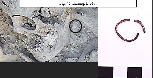
Earring (Ib_23_C_IV_317_I002)
During excavations around the skull of L-317, this silver loop earring was discovered at the base of the left mastoid process, on the north side of the head. Upon removal from the soil, the earring had a green patina and was corroded to the point of being severed in two. In total the loop measured 210 mm in diameter and was 2 mm thick. No other decorative features or stones were discovered with it or in the soil near it.
In total, 8 graves have contained earrings on the body of the interred. Two were on sub-adults, the other six were found on adult females (L-089, L-268, L-290, L-291, L-317, L-327). Except for L-089, who had two earrings with small freshwater pearls at each ear, the other adults all had simple silver loop earrings at the left mastoid process except for L-290, in which the earring was found within the soil near the right frontal lobe during laboratory examination. All three of the women in adjacent graves in U-15 (L-290, L-291, and L-317) had simple silver loop earrings. This may be another indicator of an ethno-cultural marker in this section of the cemetery (U-15).
Grave goods within L-373
Weapon and other assorted fragments (arrowheads, knives, and clothing pendants)
Ib_23_С_IV_373_I001 - I010)
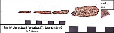
Excavations within the grave of L-373—a 18–23-year-old male at time of death—yielded 51 iron metal fragments discovered around the skeletal remains. The most significant were those fragments which were still relatively intact and identifiable. This included two metal arrowheads and two possible knives and/or spearheads, floral pendants, and other accoutrements for either a quiver or leather armor attachments. Most fragments (38) were discovered behind the parietal lobes of the skull which was turned to face north. One arrowhead and a knife (or spearhead) were found at the lateral side of the left femur, with the left hand possibly placed on top of the knife.
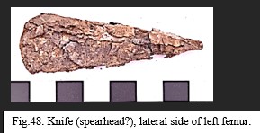
The second arrowhead was discovered northeast of the skull but closer to where the right scapula would have been, had it been in its proper anatomical position. However, the right scapula and humerus had been displaced with what would have been the entire right shoulder bent toward the north. Following decomposition, the right scapula and the attached humerus appeared to have collapsed across the thoracic cavity. This raises the question as to whether the body had been subject to rigor mortis at time of burial. It is indeterminate if the body was placed in the tomb in this state or if some natural forces such as soil shifting or roots resulted in this unusual position of the right shoulder, or if the arrowhead was part of an arrow that wounded (perhaps mortally?) the interred. However, subsequent examination of the skeletal remains showed no evidence osteologically of a wound. The left femur did have a total break which may be ante-mortem, so cause of death may have been traumatic, but again, this is still inconclusive.
While the position of this arrowhead is uncertain, the arrowhead and knife/spearhead on the lateral side of the left femur were certainly ceremonially positioned in the grave. The arrowhead was 7 cm long and a width between 2.2-1.4 cm at it narrowed to it tip. The blade was 0.3 cm thick. The larger spearhead or knife measured 10.6 cm long with a width between 2 and 1.6 cm as it narrowed to the tip, the blade was 0.2 cm thick. The shaft to either the arrows or the spearhead, (which are now fragmented into 3 pieces) when put together measure 6 cm long and are between 0.3-0.5 cm thick.
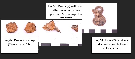
behind and north of the skull were too corroded to identify apart possibly from a specialist, some of the pieces appeared to have a decorative or functional aspect for clothing. One possible decorative piece/pendant or clasp for clothing (or armor?) has a figure-eight-shape with a fine hair-thin round wire in its mid-section and consists of one upper loop and a slightly larger sphere. Between the loop and sphere, a partition is faintly visible, on which a movable latch was attached creating a loop, which was not preserved due to oxidation. The wire was less than 0.4 cm thick and 3.4 cm long. The outer diameter of loop is 1.4 cm, and the inner diameter is 0.6 cm with the diameter of sphere measuring 2.1 cm. One possible interpretation for this piece is a clasp or button.
Another interesting fragment discovered on the medial side of the left fibula were possible rivets with screws. Based on their position near the body, one would suspect that these screws were meant to attach to something wooden, such as a quiver, or a wooden piece connected with the clothing. However, no wood fragments were discovered in the soil fill, though light brown soil discoloration was noted at the feet on the east side of the tomb. Also, within the grave fill in the upper section in the area of the torso, 3 floral-shaped pendants were also discovered in various locations. This forged iron disc-shaped fragments are heavily corroded and have a flat, pointed shaft on what is probably the posterior side with a rounded flat head, suggesting that it was attached to hard material such as wood or leather. The shape of the heads of these rivets appear to have a floral design, possibly of eight petals. Each of the rivets were almost identical in size, averaging 2 x 1.4-2 cm with a width between 0.7 to 1 cm. Two of the three pendants’ shafts were still intact and measured 2 cm long and 0.5 cm thick.

These metal fragments and the entirety of the contents of this tomb do not suggest that this young male was interred in a full set of armor, his connection (at least ceremonially) with the weapons for war and/or hunting are undeniable. It is also evident that he was buried in clothing suggesting this status as well, particularly around his head, such as a military headdress, although these metal fragments seem too sparce to suggest anything elaborate.
This is the first grave discovered in the Christian cemetery with anyone definitively having a weapon, particularly spear or arrowheads. One grave (L-299) discovered in U-16 in 2022, which was an anomalous burial with a west-to-east orientation (as opposed to the standard west-to-east burial) and in the northernmost burial in the cemetery (possibly even outside the boundaries of the cemetery) had metal placed under one of his hands, which might have been a knife, but it was too corroded to make such a determination. Nothing to the extent of this burial in L-373, however, has ever been discovered. There is no question of his identity with the Christians interred in the cemetery, due to the west-to-east orientation of the burial and the proximity to the funerary chapel was well as graves with Christian kayraks.
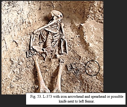
Pottery
4-nozzle lamps (Ib_23_С_IV_338_I001, Ib_23_С_IV_338_I002)
Fig. 54. 4-nozzel lamps (L-338) discovered in L-185, in martyrium.
R: Lamp 1; L: Lamp 2
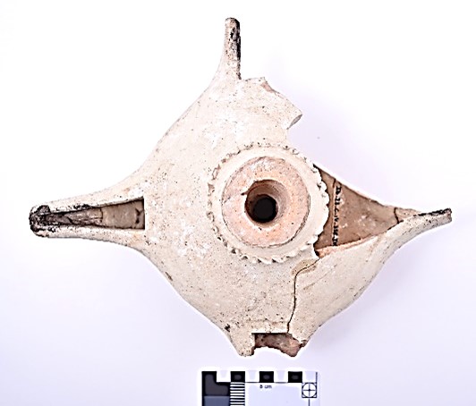
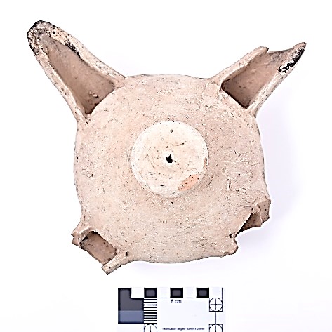
During excavations at the base of a tree within L-185, excavators discovered two archaeologically whole 4-nozzle lamps. The lamps were assigned a separate Locus 338. They rested on the compacted gray surface within what is currently interpreted as a martyrium in association with the funerary chapel (U-12) at a level of 597.285 m. asl. As the lamps were revealed in the soil, a large amount of wood was noticed nearby, which raised the question as to whether these items rested on a wooden surface or within a box. However, the presence of roots from the surrounding trees created confusion as to this interpretation. Regardless, the lamps appeared directly adjacent to one another with one (ID 001) slightly resting on the northern side of the other (ID 002).
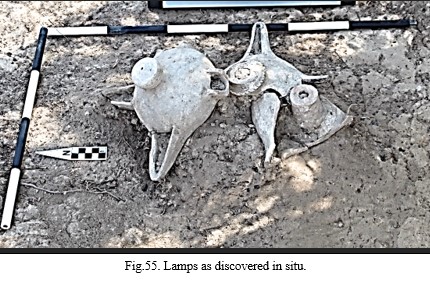
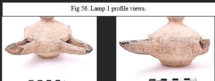
Lamp 1 was the first of the two lamps noticed in the soil through the discovery of its round knob handle which had a small drill hole in the center. As the soil was gradually removed, it revealed that it was significantly larger than anticipated. The sphero-conical oil reservoir with the four nozzles easily identifiable in the soil, even though two of the four nozzles were broken off at the intersection with the reservoir and missing. The surviving nozzles were those facing north and because the lamp was resting at an angle—later understood to be because of the second lamp’s position slightly below the first— thus, the loss of the other two nozzles was probably a result of them resting higher the soil and subject to damage from agricultural work. However, the possibility remains that they were intentionally broken prior to abandonment, or by subsequently destroyed by others.
Because this first lamp was immediately next to the natural baulk caused by the tree and because it was slightly higher and resting on top of the second lamp, excavators did not initially realize the existence of the second lamp. In fact, lamp 2 was only discovered just before extraction of lamp 1. When discovered, plans changed and both lamps were left in situ until all the soil was fully removed revealing both lamps together.
Lamp 2 experienced more damage, with almost a quarter of its oil reservoir missing and its hollow cylindrical core laying slightly south of the lamp. Only one of its four nozzles were intact. Its only surviving nozzle lay on the west side, yet it was still a few centimeters below where the two missing nozzles of lamp 1 would have rested.
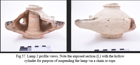
These two lamps were not alone in this section of L-185 as two other pottery fragments at similar levels were found due east. One was a common ware rim, the other a hollow cylindrical base with ascending hollow flange rings which was later identified as the foot of a chalice. Another section of this base was discovered to the south in one of the excavation units (L-341) adjacent to the chapel. Once the lamps were removed from the soil and carefully packed, they were later carefully examined in the field lab with the soil that had filled the reservoirs removed with some of that soil preserved for later analysis.
At this point both differences and similarities were noticed. Both lamps were molded from a well-variegated red clay fabric. Yet, Lamp 2 can be considered to have been crafted to a somewhat higher standard. Lamp 1 was molded by hand, but roughly smoothed giving the lamp’s surface a rough feel following firing. The center molded knob of Lamp 1 had a slightly raised neck. The entire vessel had a pinkish-white slip and is 13.9 cm tall from base to handle. The surviving nozzle tips have black charring both inside and outside showing evidence of regular usage. Lamp 1’s reservoir is 16.5 cm in diameter and was formed utilizing a potter’s wheel. It has an ellipsoid shape with rounded, yet upright walls and a 1.1 cm raised base that is 7.7 cm in diameter. Clearly, this lamp, with its 3.5 cm tall and 4.6 cm wide handle, could easily be clasped in the hand and was made to be set in a niche or on a stand within the martyrium.
Lamp 2, however, was clearly meant to hang from either a lampstand or the ceiling. This is evident due to the molded cylindrical hole that extended through the entire core of the lamp’s reservoir. It was also more decorative, with a molded flange impressed with alternating indentations by the potter using a wood or metal instrument. This upper part is a continuation of the molded sleeve that went through the core of the lamp forming a hole in which a suspension chain would pass through the lamp. The top of the cylindrical core is broken and partially missing, yet immediately above the flange and wavy rill design are circular parallel, horizontal lines, made with combing. Further evidence that this lamp was hung, probably via a metal chain, is found in the small circular indentation at the base of the lamp and encircling the hole of the base. This suggests that a metal disk attached to a chain that extended through the hollow cylinder providing support when it was hung. Further evidence will also be provided below.
Both lamps had their nozzles placed parallel to one another creating a T- or cross-shape. However, Lamp 1’s nozzles were slightly longer, yet wider, measuring 7.8 cm long and 2.9 cm wide at the point of attachment with the reservoir, narrowing to 1.8 cm at the tip. The nozzle walls were just under 1 cm. The nozzles of Lamp 2 were also more delicately and decoratively constructed, and though only one nozzle is completely preserved, their uniformity suggests they all tapered at the end and were bent slightly upward. Lamp 2’s nozzles—based on the dimensions of the surviving nozzle were 7.2 cm long and 1.8 cm wide at the point of attachment with the reservoir, narrowing to 1.8 cm, like Lamp 1. The oil reservoir, also constructed on a potter’s wheel, was 16.5 cm in diameter, identical with Lamp 1. It was 12 cm high, which is 1.9 cm shorter in height, but the raised base of Lamp 1, means that the reservoirs were almost identical in height. Oil volume, however, in Lamp 2 would have been less due to the displacement of the hollow cylinder which was 4 cm wide at the top and 5.3 cm at its base (for more details on measurements see Cultural Material Appendix).
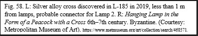
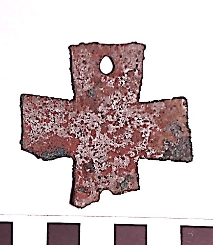
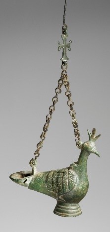
Further evidence that Lamp 2 can be considered a hanging lamp is based on an artifact discovered during the 2019 excavations. As the southern section of the cemetery in Area C was initially excavated, metal detection discovered a 5 x 5 cm, 1 mm wide metal cross with a silver alloy in the baulk of U-9C (Ib_19_C_IV_001_I025_50, 2019 Field Report, p. 228), which is on the border of what was then designated L-185 based on both this find as well as the gray compacted flooring which is now known to be the floor to the probable martyrium. The cross has two punch holes, parallel to each other on the ends of two of the cross bars.
Originally, it was thought the cross with the punch holes was meant to be attached to a wall, or potentially a coffin (as discovered by Pantusov at Kara Jigach in the 1880s). Now, however, given that this metal cross was found within less than a 1 m radius (if not closer) to Lamp 2, it is almost certain that this cross served as an attachment point for the chain that suspended Lamp 2 in the martyrium, even directly over grave L-258 and possible grave L-257. A single connecting chain (which has not been found), would have attached to the upper hole of the cross suspended from the ceiling or a lamp pole. Then, the lamp chain with a metal disk support would have extended through the lamp’s hollow cylinder and connected with the bottom punch hole of the cross. It is possible that the lamp chain surrounded the body of the lamp with three chains gathered at a connecting hook that then attached to the cross. Other examples exist of similar multi-nozzle lamps utilizing cross and Christian iconography in Byzantine Christian contexts dating as early as the 4th century (Byzantine and Christian Museum (2010), 42-43, fig. 43-44; Boura, 2008). Only one punch hole survives fully intact on the metal cross discovered in L-185, but the metal does seem to be elongated which makes it more teardrop-shaped. This suggests that the cross bore weight while used, demonstrating a more utilitarian than merely decorative function.
Additionally, ceramic multi-nozzle lamps have also been found in Central Asian archaeological contexts. Two example of lamps that are quite similar with both Lamp 1 and Lamp 2 were discovered by Karl Baipakov’s team at the site in Talgar which is only 250 km southwest of Ilibalyk (Baipakov 2009; see also Baipakov, 2011a). Not only are these lamps similar in style and construction, but also, they date between the 12th to 14th centuries— within the exact same chronology as these lamps at Ilybalyk.
These artifacts show the combination of local ceramic technology with the Christian community’s iconography and religious ceremony. It also speaks, once more, of the sacred space in this part of Area C and provides additional support to the team’s interpretation of the sacred use of the both the funerary chapel and the now newly discovered martyrium.
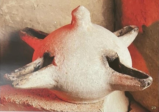
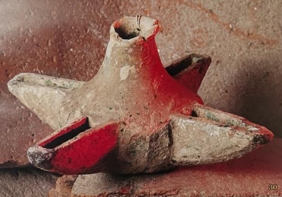
![]()
Chalice foot (Ib_23_C_IV_339_I001; Ib_23_C_IV_341_I001)
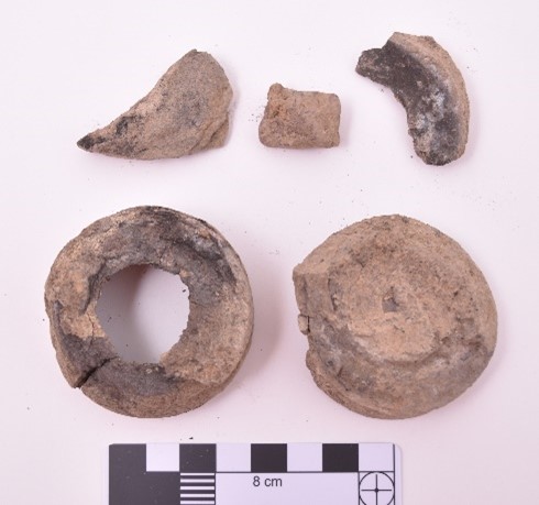
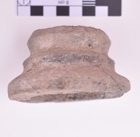
![]()
As excavators cleared the soil within L-185, north of the line of trees and approximately 10 cm to the west of the two 4-nozzel lamps (L-338), they discovered a round, cylindrically shaped gray ceramic object, which was eventually identified as the foot to a chalice. It was made of a well variegated gray clay and had an ascending layer of hollow flange rings with a broad, round ring base. It was discovered very close to the gray compacted floor of the area currently interpreted as a martyrium at a level of 597.291 m. asl.
Later, during clearing operations in test trench L-341 (which lies within L-333), and due south of L-185, more pottery fragments, also of well-variegated gray fabric, were discovered. Only after later examination in the field lab was it determined both sets of fragments belonged to the same vessel.
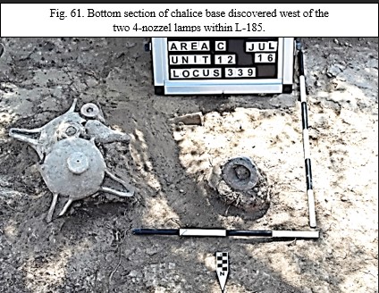
The L-338 fragment was the lower portion of the chalice’s foot. It measured 5.2 cm high, and the sidewall is 0.8 cm thick. The ring base is 8.3 cm wide with the upper portion narrowing to 5.5 cm. The fragment from within L-341, which joined directly to the upper portion of the base, had two additional flange rings, which were severely cracked. Upon cleaning, these two rings separated. This portion of the foot is 5.5 cm wide and eventually narrows in the upper flange to 1.6 cm wide.
Next to this portion of the foot, two broken pieces of the chalice well were discovered, which fit directly onto the top of this second discovered portion of the foot, and it measured 6.1 cm wide. There were sharp breaks around each side of the well, indicating that it was an open mouth rounded vessel when whole. Once cleaned, it also became evident that the vessel had been subject to burning, with charring on both portions of the chalice foot.
Since 2020, with the initial discovery of the funerary chapel, high status and glazed ware pottery which could be used for religious and liturgical purposes has appeared throughout the structure’s remains. This has included a possible icon lamp or thurible; porcelain ware imports from either Persia, Syria, or China; a glass fragment to a gold-painted vessel; glazed lamps with cruciform-designed thumb guards; a glazed footed goblet similar to vessels known on Cyprus; and Jun ware pottery from China, the latter two examples found within the possible altar room or eucharistic bread preparation area (2020 Field Report, pp. 53-73; 2021 Field Report, pp. 58-63; 2022 Field Report, pp. 169-176). This chalice foot, discovered within the currently interpreted area of the martyrium, with one part adjacent to the 4-nozzle lamps, is now added to this collection of fine ware whose weight of evidence speaks to the sacred space south of the Christian cemetery within Area C. The two fragments of the chalice foot located within 4 m of each other in a straight-line north-to-south and both within the supposed walls of the martyrium, suggests it was used within this part of the complex. The charring on this vessel indicates that at some point it was subject to burning, but the evidence is mixed as to whether this shows destruction prior to or following abandonment of the structure.
Glazed Neck of Vessel (Ib_23_C_IV_336_I002)
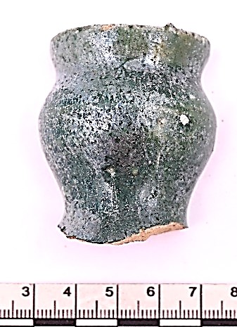
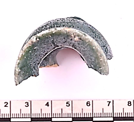
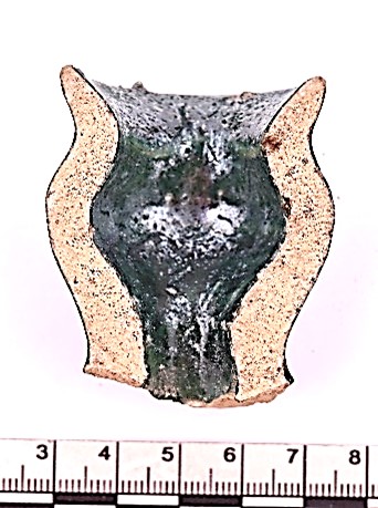
![]()
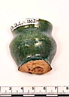
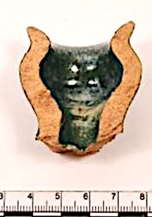
![]()
Excavators discovered this glazed pottery fragment on the north side of test trench L-336 which lies within L-333, the location due north of the funerary chapel’s north wall. This curved, cup-shaped piece of green-glazed ceramic fine ware with glaze on both sides was probably used for ceremonial purposes. It was made from a well-variegated yellow fabric with small inclusions of mica particles and formed on a potter’s wheel. The neck has a slightly everted rim that tapers upward to a thin lip. The rim passes smoothly into the body in its mid-section. It measures 5 cm tall with a diameter of 3.8 cm and a sidewall width that varies between 0.4-0.8 cm.
The other half of this fragment was discovered during the 2020 excavations in L-230, the chapel’s nave floor or slightly above it in the soil fill (See 2020 Field Report, pp. 130, 177; Ib_20_C_IV_230_I001). The halves join and are from the same vessel, however, the fragment discovered this season was subject to burning based on the charring and fading of the glaze’s sheen and micro-sized bubbles in the glaze. Burning was documented throughout this trench, possibly at rather high temperatures. Since the first discovered fragment does not have this same charring, it can be inferred that the vessel was broken before this fire within L-336 occurred.
When the first fragment was found, it was interpreted as the capital of a candlestick. This interpretation, however, is disputed and unlike most candlestick capitals, the neck extends along a narrow canal, presumably into the body of the vessel. Therefore, perhaps a better interpretation is this is the neck to a wine decanter. The ceremonial use of wine, particularly during the taking of the Eucharist in Christian settings is well documented throughout Christendom, dating to its founding in the first century.
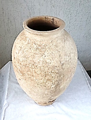
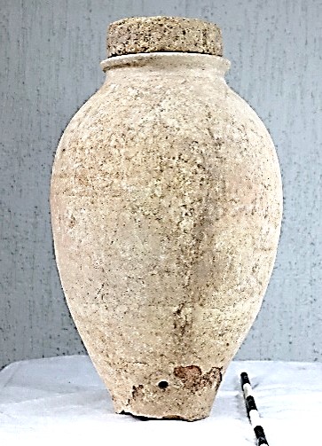
![]()
Storage Jar (Khum) with Fired Brick Stopper (Ib_23_C_IV_346_I001
During excavations in the 2 x 2 m test trench (L-336) due north of the northern wall and possible entrance to the bema area of the funerary chapel, this entirely whole pottery vessel (khum/storage jar) was discovered within the floor of what is currently interpreted as the martyrium. It had been intentionally inserted into the floor for food or liquid storage and covered with a fired brick which had been rounded to sit on top of the vessel’s flat rim (for details on the excavation process and specific measurements, see locus description L-346, and the cultural materials appendix). During the process of revealing the jar, traces of a wall or retaining platform was discovered to the east of the vessel on the occupational surface and assigned Locus 365. It is possible that this section served as a step or base for a platform to the north of the chapel’s bema.
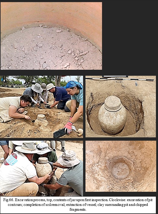
During excavations in the 2 x 2 m test trench (L-336) due north of the northern wall and possible entrance to the bema area of the funerary chapel, this entirely whole pottery vessel (khum/storage jar) was discovered within the floor of what is currently interpreted as the martyrium. It had been intentionally inserted into the floor for food or liquid storage and covered with a fired brick which had been rounded to sit on top of the vessel’s flat rim (for details on the excavation process and specific measurements, see locus description L-346, and the cultural materials appendix). During the process of revealing the jar, traces of a wall or retaining platform was discovered to the east of the vessel on the occupational surface and assigned Locus 365. It is possible that this section served as a step or base for a platform to the north of the chapel’s bema.
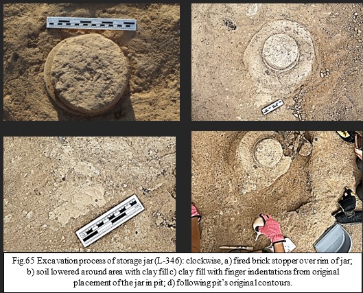
While clearing the soil for the jar’s removal, it was discovered that within the mud compacted floor, liquid clay had been inserted within the voids between the vessel possibly to seal and stabilize the jar. The seal was briefly removed to inspect the contents of the jar which was also photographed. The contents, which was later measured to be up to 26 cm deep, or halfway to the top, was soil fill, later inspected in laboratory conditions. Following recordation of the clay fill, the excavators began removing soil based on the contours of the original pit. Once the amphora was completely revealed and photographed, it was carefully removed and placed in protective material and transported with a wheelbarrow to a vehicle and taken to the field lab. Following removal, it was noticed that parts of the base had stuck to the soil in the bottom of the pit and chipped off the base. This may have been due to adhering to the clay originally placed in the pit, or to liquid from the vessel seeping through a 10 x 10 mm pour hole that was bored 4 cm above the jar’s base. This may have created a natural clay sealant weakening the ceramic on this part of the vessel. These pieces were gathered and placed in a bag for later rejoining.
In the field laboratory, the jar was inspected and measured in totality and then packed in a protective equipment for transport to Almaty where the contents were inspected for the purpose of taking analytical samples. This second inspection involved the removal of the soil fill and to see if any other cultural or organic material might be discovered. The initial 3-4 cm layer of the soil was somewhat compacted, whereas the remainder of the soil was a loose brown loam. The inner surface wall where the soil had reached its highest level in the jar a dark ring around the wall’s circumference. Soil samples were taken of the top, middle, and bottom section of the fill. No further material was discovered within the fill that was carefully inspected. A scraping of the jar’s inner wall was taken at the spot of the dark ring and bagged for future analysis. Additional photographs were taken, and a 3-D model was created. (See https://sketchfab.com/3d-models/ilibalyk-pottery-vessel-a542ef4727e841b9a697c100fd38860d).
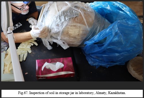
This is the first completely whole vessel discovered during excavations at Ilibalyk. Whereas other whole vessels have been discovered by local villagers and some vessels exist in the Zharkent Mosque Architectural and Arts Museum, this is the first whole vessel discovered in situ under archaeologically controlled conditions. The storage jar is considered common ware with no decorative or ceremonial importance and was used exactly as its name indicates—for storage, probably of food or liquid. Many potsherds from similar vessels have been discovered over the course of excavations at Usharal-Ilibalyk, including sherds with a hole in which liquid could pass through. In fact, in the Russian-language context, these jars are often called aquifers (amphoras in western contexts) since the consensus is they stored liquid. This raises the question, however, that if it stored liquid in the ground, why would they use a vessel with a hole at the base, risking spillage of the contents. This may explain why clay was used at the base of the pit, possibly as a sealant to protect the contents.
Storage jars buried in pits was a common practice in antiquity not just in Central Asian contexts but around the world and helped preserve foods or liquids in a cooler environment. In Central Asia, they most often appear in household settings, specifically buried in raised, soil sufas which were the ancient and medieval equivalent of modern kitchen countertops where food was stored prior to cooking. In the case of our storage jar, however, it seems to be placed within the floor of the martyrium next to either a retaining wall or structural wall and near the bema and altar area of the chapel. Given the context, this means it could have contained wine for communion services related to funerary rites. This hypothesis can hopefully be confirmed if the soil and ceramic samples taken from the jar reveal either lipids (indicating meat) or organic residue from grapes (thus, wine).
Khum Rim with Floral Stamp Impressions (Ib_23_С_IV_334_I001)
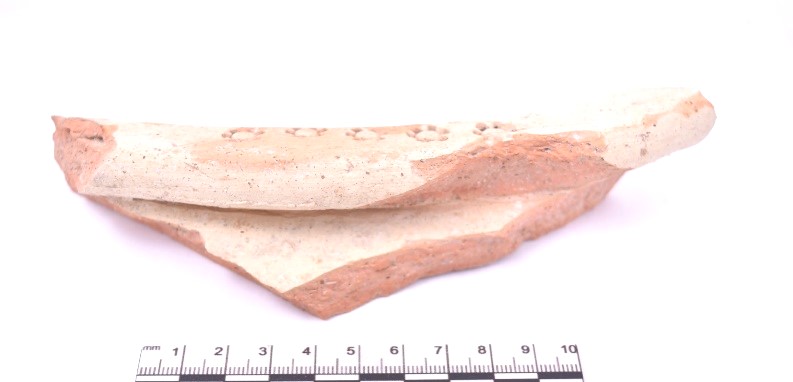
![]()
This rim to a giant pithoid (khum) was discovered in the upper horizon on the east side of U-12 beyond the funerary chapel within the fill of L-334. The vessel was made of a red clay fabric with large mica and micro-sized pebble inclusions, and it was covered with a white slip. The rather worn potsherd has a flat, everted rim with a small portion of the sidewall present. What makes this rim distinct are the stamped 6-petal floral impressions across the rim’s surface. There are 7 flowers in total, with 5 in a row on the flat surface less than 1 cm apart and 2 on the inner side of the rim also equidistance apart. It is probable that the pattern continued around the entirety of the rim. The first 5 flowers on the rim surface are separated from the 2 flowers on the inner side of the rim by 4 cm. This potsherd measures 17.5 x 4.68 x 4.03 cm.

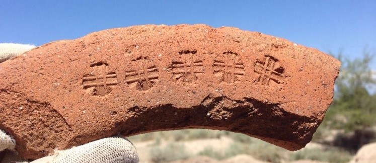
Such stamped impressions on these large pithoids are not uncommon in the Central Asian context and have also been found on the site at Ilibalyk, specifically a rim of similar size discovered in the area of the shahristan in 2016 (IB-16-2-17-1, 2016 Field Report, p. 250). That rim had a stamped impression of 5 crosses, though it is uncertain if these cross stamp impressions signify any connection with Christianity.
Glass
Beads (Ib_23_В_IV_326_I001)
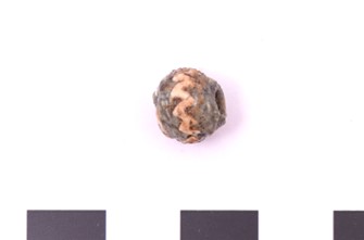
Fig. 70. Bead. Locus 326
During excavation of a sub-adult grave (estimated 10-12 yrs.) in L-326 on the far southern edge of U-15, 3 beads, presumably to a bracelet were discovered on the lateral side of the right ulna. Additionally, 3-4 fragments of even smaller beads were discovered in between the medial section of the left ulna and radius. Following removal from the grave during the cleaning process, only one of the beads located at the right wrist remained intact.
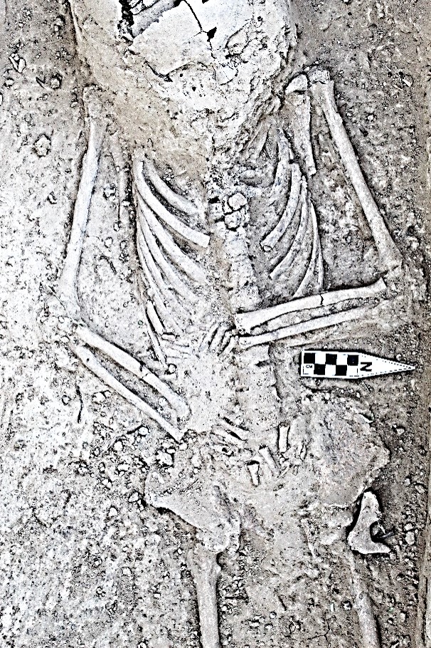
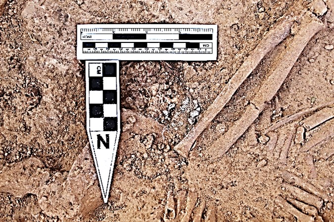
Fig. 71 Bead discovered in L-326 at right and left forearms.
This surviving cylindrical bead, made of an opaque, light green glass paste had a 3 mm center drill hole. It was 9 mm long and 8 mm wide with a wavy 1 mm strip insert of white glass circumventing the bead. Based on its location and being with the other two beads, it is logical to assume these beads were part of a bracelet. The smaller beads, which do not exceed 1-2 mm in circumference, while between the left tibia and ulna cannot be attributed as being part of a bracelet. These beads might have been attached to the clothing in which the child may have been buried.
In total, excluding these newest finds in L-328, 133 beads have been discovered throughout Field IV. Some of these are random finds that have no association with any grave. However, 14 graves have had beads as grave goods within the tomb with 11 of those being in sub-adult graves. The only female adults buried with beads were L-290, (a female with the boqtag headdress with embroidery beads), and L-089, (a female with earrings, rings, and bracelets, including beaded bracelets). One adult male (L-277) had a lone bead in his cervical region. Among the children, most of the beads are the micro-sized, which appear to be embroidery beads attached to clothing. On two occasions beads were at the neck, L-012 (that had beads included with an avian bone necklace) and L-009 (with two beads, including a carnelian stone at the upper thoracic region near the neck).
The beads at the right wrist of L-326 are the first beads found in situ at the wrist of a child. The use of these beads may simply be aesthetic to adorn clothing or the human person. However, it may also be possible that these beads served an apotropaic purpose, such as warding off sickness or evil. While this practice was discouraged through the ages by the Church, including the Church of the East, such syncretistic practice cannot be ruled out in these Turko-Persian settings.
While nothing is known of the use of beads as amulets among Central Asian Christians during the medieval period, written prayer amulets, probably secured in leather pouches and worn around the neck, were discovered at the Christian monastery in Shuipang, Bulayïk in the Turfan oasis ((Dickens, 591-594; Hunter, 2022, 260). Even today, among Kazakhs, mothers will place small, beaded bracelets on an infant with this purpose in mind, and people of all ages wear the tumar, a leather pouch containing Quranic verses given to them by the local header known as a emsha or tayip, which seems to have been similar to the prayer amulets of Shuipang, though there is no evidence they were worn around the neck in a pouch as the above example.
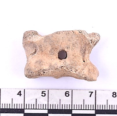
Fig. 72. Assyk bone (talas) disvoered in L343
Asyk (Ib_23_C_IV_343_I001)
In the second layer, L-343, on the east side of U-12, excavators discovered an adult sheep’s talas bone that contained a drilled hole in its center. The bone measured 3.1 x 1.95 x 1.96 and the diameter of the hole is 5 mm. This find was in the context of other pottery and bone fragments with areas of burning to the east of the chapel, but at a level which probably predates the chapel’s construction.
This bone is commonly found in Central Asian archaeological contexts and is often attributed as being a child’s game piece known as an assyk, which is played even today among Kazakh children. Assyk includes dozens of different games that can be played using the bones and dates back many centuries, though no known documentation can trace its origins. In 2017, UNESCO listed the assyk game as a component of intangible culture (https://ich.unesco.org/en/RL/kazakh-traditional-assyk-games-01086#:~:text=Kazakh%20traditional%20Assyk%20games%20are,the%20position%20of%20the%20bone.)
The special nature concerning the assyk in Central Asian Turkic culture was highlighted in 2019 when an archaeological team under the auspices of Dr. Dmitry Voyakin and sponsored by the Society for the Exploration of Eurasia at the site of Kesken Kuyuk Kala in southwest Kazakhstan found 2 bronze assyk replicas. The site which lies east of the Aral Sea—which has been highly impacted by desertification and the shrinking of this inland sea—is attributed as being the medieval city of Juvara, connected to the Oghuz Turks (9th-10th c. AD) and later by Kipchak nomads following the Mongol conquest, in which the city fell into decline.
The discovery of the bronze assyk bones were a very anatomically correct rendering of the sheep talas (2019 Kesken Field Report, pp. 152-153) and this was the first time such artifacts depicting assyk pieces in bronze had ever been discovered in Central Asia. Actual talas bones have also been discovered on the site in domestic contexts, with markings on the body of the bone, which appear to be intentional, though it may have simply been the result of butchering. (p. 171).
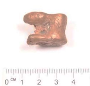
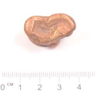
Fig.73. One of two bronze assyk discovered at
Kesken Kuyuk Kala in 2019.
(2019 Kesken Kuyuk Kala Field Report, 153).
Bronze assyk pieces (known as an astragalus) date back as early as the 5th century BC where they have been discovered in Greece. The consensus is that these bronze talas replicas were for gaming. Others have speculated that they served as votive gifts at pagan shrines or as a component of divination (Crawford, 213).
Conclusion
With each passing excavation season, the story of the Christians of Ilibalyk comes more clearly into view. The Usharal-Ilibalyk excavations have now demonstrated that not only did a multi-generational Christian community exist within this city during the late medieval period, but also they comprised a multi-ethnic group of Persian and Turk urban dwellers across a wide-strata of economic and social status with an organized clergy together with Turko-Mongolian nomads who also identified themselves as Christian. Their common language, Old Turkic, and common religion, Christianity, specifically Church of the East (Nestorian) united them. Yet, as the tombs—particularly in U-15 and U-17 demonstrate— they also reveal their cultural distinctiveness as well.
As revealed both by the kayrak (gravestone) inscriptions as well as the presence of a possible martyrium or mausoleum located due north of the funerary chapel; the community had a shared religious history with namesakes within the community from past Church of the East saints (i.e. Baršabba, Shirin, Febronia, etc.), while they also commemorated their own clergy and possible missionaries (Baršabba Quča, Yošmid the priest) who may have founded their own community in the early 13th century.
Based on this season’s excavations, it now has become apparent that this possible martyrium was either a wing on the chapel or was erected prior to the chapel’s construction as a stand-along mausoleum. It was set apart from the other graves in the cemetery and may contain additional graves yet to be revealed due to the tree obstructions which made complete excavation impossible. The discovery of the 4-nozzle lamps and chalice base which were within the same possible structure as these tombs enhances the interpretation of this space as something set apart and religiously significant. It is a strong inference that these lamps were meant to light these tombs (perhaps with a continually maintained flame?) and marked with a stone commemorating the burials within (Yošmid stone).
The discovery of the whole storage vessel with brick stopper intentionally submerged in the soil—either within this northern chapel wing or between the two structures—speaks to the final days of the community, as it most remained in place at the time of the structure’s abandonment or destruction. While the contents of this vessel are unknown pending analysis, wine used for ritual sacraments as a part of funerary rites is a logical and sensible conclusion.
Excavations to the chapel’s east confirm no other structure existed on this side of the chapel nor were graves present in this section. Earlier occupation seems confirmed based on the discovery of cultural material, as does post-chapel occupation with the presence of secondary usage of fired brick, burning pits and pottery fragments above the known 13th century occupational surface. While more investigation is needed concerning the paksa (tamped earth) walls on the east side of U-12 related to phasing, it does seem possible that a retaining wall or raised platform may have separated the altar area of the chapel from the rest of the cemetery, serving as a boundary of sorts. The floor of the martyrium, like the other flooring of both the nave and altar, were covered by a mixture of packed gray loam and ash, which currently is interpreted as a steady accumulation of ceremonial ash as opposed to a sudden destruction by fire, as was concluded in 2020. This interpretation is supported by its compacted nature and the presence of charcoal throughout the layer which is bolstered by the known use of ash for mourning in Syriac Christian rites, and certainly a funerary chapel would constitute a place of mourning for the dead.
Another major discovery with an accumulation of evidence over the past three seasons are the graves in Units 15 and 17. This section of the cemetery is proving unique from the other graves due to both grave construction (i.e. large size and wooden coverings or structures) and the inclusion of grave goods consistent with Turko-Mongolian nomadic graves from this era (12th-13th centuries). Scissors have been found within three graves (L-291, L-290, and L-317) that are adjacent to one another in a row proceeding north-south. All these graves contained females, with one (L-290) having a boqtag headdress—a symbol of very high social status. The grave excavated this season (L-317) adjacent and south of L-290, had an even larger grave structure with the most extensive wooden construction within the tomb discovered to date, containing a wooden roof covered with mudbrick. All three of these women had a single silver loop earring in their left ears, which also carries the suggestion of a cultural marker. Non-metric cranial features along with shovel-shaped incisors also speak to their Asian identities, although these features have also been found among the interred throughout the cemetery, yet not exclusively.
The grave L-373 which contained a young male with remnants of weapons, is located just southwest of the tombs with females, and is the first “warrior” discovered to date within the cemetery. He, too, speaks to the special nature of this section and suggests a Turko-Mongolian connection which has not been as obvious among the graves on the western half of the cemetery. If the preliminary investigation on his pelvis is accurate, then the ware on his bones suggest that he rode a horse, also a sign of wealth and status, and may demonstrate a “warrior class” among the Christians of Ilibalyk.
Despite the more distinct ethno-cultural markers attributed to these particular graves, this does not suggest a difference in religious identity. This is due to the continued west-to-east orientation of the graves and the reader should be reminded of the large kayrak with cross inscription (L-310) discovered immediately on top of the grave of L-290, the “khatun” (princess) with the boqtag headdress. While the grave goods with scissors and weapons may be consistent with non-Christian Turko-Mongolian burials; orientation and location along with gravestone inscriptions and the nearby Christian chapel clearly serve as a strong religious identity indicators still firmly within the Christian fold.
This would also be consistent with what is known historically via textual evidence. Turko-Mongolian tribes, specifically Naiman, Kereit, Kipchak, and Öngüt, were among those who identified as Christian and were observed as Christian adherents by visitors to the region between the 11th-14th centuries. This, then, obviously raises the question, as to whom exactly these obviously Turko-Mongolian people were buried within the Christian cemetery at Ilibalyk. Pending aDNA analysis notwithstanding, it may be possible to now state that this may be the first archaeological evidence of Turkic nomadic Christians ever discovered. The most logical people based on the geographic location would be Naiman or Kereit, with the former the most likely candidate. Certainly more evidence and potential laboratory analysis could shed further light and confirmation on this assertion and will be necessary before a firm conclusion such as this can be made.
The excavation of Unit 18, due east of Unit 15, also revealed more human remains and grave chambers within the soil. This now extends the eastern boundary of Area C by an additional 13 meters. A connection between the lone grave discovered in Area B in 2020 has yet to be established, however, it seems more likely that such a link is in the offering should excavations continue in this easterly direction.
Certainly, more investigation is warranted, particularly in the northern section of Unit 12 to determine if the currently interpreted martyrium is a northern wing of the chapel or is a separate structure. Expansion of excavations to the south and east of Units 15 and 17 could also allow for greater understanding of the graves in this section. The newly acquired LiDAR drone which was employed this season has also provided results and areas of interest which can be explored in the future which could help determine the relationship of the cemetery to the remainder of the medieval city. Additional genetic and potential stable isotope analysis could also answer questions concerning ethnicity, pathology, and immigration. The past eight seasons of excavations have both answered and raised a plethora of questions that can continue to be investigated in depth far into the future.
Selected Bibliography
Allsen, T. (2001) Culture and Conquest in Mongol Eurasia (Cambridge).
Altman, J. (1979) “Gold in Ancient Palestine: Methods of Fabrication in Successive
Cultures,” Gold Bulletin12.2: 75-82.
Amanbaeva, B. and V. Kolchenko (2011) “Kyrgyzstan”, Художественная Культура
Центральной Азии И Азербайджана (Ix–Xv Веков) (Tashkent: IICAS), 85-127.
Arslanova, A. (2005) “Russian Research on the Interrelations of the Golden Horde with
the Ilkhans of Iran and the Chaghatayids”, Acta Orientalia Academiae Scientiarum Hungaricae 58. 3 [Proceedings of the First International Conference on the Mediaeval History of the Eurasian Steppe: Szeged, Hungary May 11—16, 2004: Part III]: 277-293.
Ashirbekov, Y., Seidualy, M., Abaildayev, A., Maxutova, A., Zhunussova, A., Akilzhanova,
A., Sharipov, K., Sabitov, Z., & Zhabagin, M. (2023) “Genetic polymorphism of Y-chromosome in Kazakh populations from Southern Kazakhstan.” BMC Genomics, 24(1), 649. https://doi.org/10.1186/s12864-023-09753-z.
Assev, I.V. (2009) Неоторые аспекты исторических и археологических материалов как
свидетельства расселения монголоязычных племен в байкальском регионе и монголии в средние века [Some aspects of historical and archaeological materials as evidence of the settlement of Mongol-speaking tribes in the Baikal region and Mongolia in the Middle Ages] Bulletin of NSU. Series: History, Philology. Vol. 8, Issue 5: Archeology and Ethnography.
Baipakov, K. and O. Kuznechova (2011) “Kazakhstan,” Художественная Культура Центральной Азии И Азербайджана (IX–XV Веков) (Tashkent: IICAS), 22-84.
Baipakov, K., S. Pidaev, and A. Hakimov. (2011a) Художественная культура
Центральной Азии и Азербайджана IX–XV вв., Vol. I. Керамика [Artistic Culture of Central Asia and Azerbaijan in the 9th–15th centuries, Vol. I. Ceramics] Samarkand-Tashkent, UNESCO-IICAS.
Baipakov, K. and P. Petrov. (2015) “Locating the Town of Ilanbalyk in the Ili
Valley,” Bulletin of IICAS (Samarkand) 21: 80-87.
Baipakov, K. and G. А. Ternovaya (2018) “Христианство в Южном Казахстане и
Семиречье (VI-XIV вв.)” [Christianity in Southern Kazakhstan and Semireche (6th-14th centuries)] in D. A. Voyakin, ed., Религии Центральной Азии и Азербайджана. Том IV. Христианство, [Religions in Central Asia and Azerbaijan. Vol. 4, Christianity] Samarkand: International Institute for Central Asian Studies: 8-47.
Barthold, V. (1928). Turkestan Down to the Mongol Invasion. London: Luzac & Co.
_____. (1963) Ocherk istorii Semirechye. Sochineniya, Vol. 2, Part 1 (Moscow:
Izdatel'stvo vostochnoj literatury.
Baumer, C. (2016) The Church of the East: An Illustrated History of Assyrian
Christianity (New Ed. London: I.B. Tauris).
_____. (2016) History of Central Asia, Vol. 3: The Age of Islam and the
Mongols (London: I.B. Tauris).
Berthon, W., B. Tihanyi, L. Kis, et al. (2019) “Horse Riding and the Shape of the
Acetabulum: Insights from the Bioarchaeological Analysis of Early Hungarian Mounted Archers (10th century).” Int J Osteoarchaeol. 2019; 29: 117- 126. https://doi.org/10.1002/oa.2723.
Biran, M. (2008) “Diplomacy and Chancellery Practices in the Chagataid Khanate: Some
Preliminary Remarks”, Oriente Moderno, Nuova serie 88. 2:369-393.
_____. (2009) "Central Asia from the Conquest of Chinggis Khan to the Rise of
Tamerlane" The Chinggiside Age// The Cambridge History of Inner Asia 2, ed. Di Cosmo. et al., (Cambridge: Cambridge University Press): 46-66.
_____. (2013) Qaidu and the Rise of the Independent Mongol State in Central Asia
(London: Routledge).
Boura, L., M. Parani (2008) Lighting in Early Byzantium (Washington DC, Harvard
University Press and Dumbarton Oaks).
Brock, S. (2009). A Brief Outline of Syriac Literature (Kerala: SEERI).
Brown, R. (2020). "The Significance of the Ilibalyk Nestorian Cemetery
Archaeological Discovery as Sacred Space for Kazakh Christians." In Sacred Geography: Multidisciplinary Approaches in Space and Time, 162-78. Nur-Sultan: Nazarbayev University.
Byzantine and Christian Museum. (2010) Byzantine Collections: The Permanent
Exhibition. Athens: 42-43, fig. 43-44.
Chaillot, C. (2023). The Assyrian Church of the East: History and Geography. Peter
Lang: Oxford.
Crawford, J., S. Goldstein, G. Hanfmann, J. Kroll, J. Lerner, M. Marvin, C. Moore, and D.
Roller, (1970) Objects of Ancient Daily Life. A Catalogue of the Alice Corinne McDaniel Collection Belonging to the Department of the Classics, Harvard University, ed. Jane Waldbaum, Department of the Classics. (Unpublished manuscript).
Dickens, M. (2021) "Syro-Uigurica III: Enochic Material in a Christian Text from Turfan".
Acta Orientalia Academiae Scientiarum Hungaricae 4:583-624.
Gilbert, S. (2022) “The Church of the East Cemetery at Ilibalyk,” Silk Road Traces: Studies
on Syriac Christianity in China and Central Asia. Eds. Li Tang and D. Winkler (Berlin: Lit Verlag): 37-55.
Grabka, G. (1953) "Christian Viaticum: A Study of Its Cultural Background." Traditio. 9 (1):
1–43.
Halbertsma, T. (2015) Early Christian Remains of Inner Mongolia Leiden: Brill, Revised.
Halbertsma, T. (2022) “The Crosses of Shizhuziliang: Tracking down Eight Christian Gravestones and a Marble Base,” // Silk Road Traces: Studies on Syriac Christianity in China and Central Asia. Eds. Li Tang and D. Winkler (Berlin: Lit Verlag): 69-103.
Hunter, E. (2022) “Cursive Palaeography at Turfan: Exploring ‘Medial’ Estrangelā” Silk Road Traces Studies on Syriac Christianity in China and Central Asia [orientalia - patristica - oecumenica 21] (Vienna, Lit Verlag): 253-270.
Juvaini, Ata-Malik, Tarīkh-i Jahān-gushā [Engl. translation and commentaryby J. Boyle, History of the World Conqueror (Cambridge: Harvard University Press, 1958)].
Kharinskii A.V., Orgilbayar S., Korostelev A.M., Erdenebaatar D., Portniagin M.A., 2023.
Mogil’nik XI– XIII vv. Zuun Hyaryn Denzh 1 na severnom poberezh’e ozera Hubsugul (Mongoliya) [Zuun Hyaryn Denj 1 Burial Ground of the 11th – 13th Centuries from the Northern Shore of Lake Khubsugul (Mongolia)]. Nizhnevolzhskiy Arkheologicheskiy Vestnik [The Lower Volga Archaeological Bulletin], vol. 22, no. 1, pp. 289-307. DOI: https:// doi.org/10.15688/nav.jvolsu.2023.1.14
Khussainova, E., Kisselev, I., Iksan, O., Bekmanov, B., Skvortsova, L., Garshin, A.,
Kuzovleva, E., Zhaniyazov, Z., Zhunussova, G., Musralina, L., Kahbatkyzy, N., Amirgaliyeva, A., Begmanova, M., Seisenbayeva, A., Bespalova, K., Perfilyeva, A., Abylkassymova, G., Farkhatuly, A., Good, S. V., & Djansugurova, L. (2022) “Genetic Relationship Among the Kazakh People Based on Y-STR Markers Reveals Evidence of Genetic Variation Among Tribes and Zhuz.” Frontiers in Genetics, 12, 801295. https://doi.org/10.3389/fgene.2021.801295.
Kolchenko, V. (2002) “Заметки О Христианстве В Чуйской Долине В Средние
Века,” (Notes about Christianity in the Chui Valley in the Middle Ages)”, Коомдук илимдер журналга (Bishkek: Kyrgyz-Turkish University "Manas”): 163-182.
_____. (2003) “Периодизация распространения христианства в Средней
Азии по данным археологии” (The periods when Christianity Spread into Central Asia according to Archeology), Буддизм и христианство в культурном наследии Центральной Азии (Buddhism and Christianity in the cultural heritage of Central Asia) (Bishkek): 53-73.
_____. (2013) “Кара-Джигачское (При-Пишпекское) средневековое
кладбище (археологический аспект)” [Kara-Dzhigachskoe (Pre-Pishpek) medieval cemetery (the archaeological aspect)], An International Paschal Reader: Collection of Materials (Bishkek): 81-83.
_____. (2018) “Кыргызстан, (Kyrgyzstan) ”in D. A. Voyakin, ed., Религии
Центральной Азии и Азербайджана. Том IV. Христианство, (Religions in Central Asia and Azerbaijan. Vol. 4, Christianity) Samarkand: International Institute for Central Asian Studies, 2018: 48-103.
Kolsov, P. M., K. P. Kolsova, V. V. Vereshagin. (2018) “Родовые могильники кочевников золотой орды на территории калмыкии” [Family Grave Groups of the Golden Horde Nomads in the Territory of Kalmykia] Medieval Archaeology: Materials of the 8th International Scientific Conference “Dialogue of Urban and Steppe Cultures in the Eurasian Space,” dedicated to the memory of G.A. Fedorov-Davydov. Vol. 4.: 73-87.
Kradin, N. N., S.E. Baksheeva, E.V. Kovichev, A.V. Kharitsky (2016) "Археология
империи Чингисхана в Монголии и Забайкалье” [Archeology of the Genghis Khan Empire in Mongolia and Transbaikalia] Российского научного фонда (проект № 14-18-01165 «Города средневековых империй Дальнего Востока»). [Russian Science Foundation (project No. 14-18-01165 “Cities of medieval empires of the Far East”].
Li, J., J. Esimbek, Y. Ma, (2024) “Investigating the Orientation Patterns of Gumugou Cemetery (3800 BP) in Xinjiang, China,” Journal of Archaeological Science: Reports, Vol. 54: 1-7.
Lollard, J. (2018) A Sanctifying Myth: The Syriac History of John in Its Social, Literary,
and Theological Context. (Unpublished Ph.D. dissertation, Florida State University, Tallahassee.)
Longenecker, B. (2015) The Cross Before Constantine: The Early Life of a Christian
Symbol (Minneapolis: Augsburg Fortress Publishers).
Maklasova, L. and V. Maklasov. (2023) Otchet ob isslevdovanii golovnogo ubora Boktag iz
Pogrebeniy a L-290 pamyatnika Usharal-Ilibalyk, Kazakhstan, v 2023 godu. [Main Investigative Report on the Removal of a Boktag from Grave L-290 of the Usharal-Ilibalyk Site, Kazakhstan in 2023] O.N. Khalikova Institute of Archaeology, Academy of Sciences, Republic of Tatarstan, (Kazan, Russia).
Millward, J. (2009) “Eastern Central Asia (Xinjiang): 1300-1800,” The Chinggisid Age.
Cambridge: Cambridge Univ. Press.
Nugeteren, H. and J. Wilkens. (2019). “A Female Mongol Headdress in Old Uyghur Secular
Documents,” International Journal of Old Uyghur Studies 1/2: 153-170.
Pantusov, N. (1886) “Христианское кладбище близ г. Пишпека (Семиреченской области) в Чуйской долине”, [A Christian Cemetery near Pishpek (Region of Semirechiye) in the Chu Valley], in Zapiski Vostochnogo otdeleniya Rossiĭskogo arkheologicheskogo obshchestva [Transactions of the Oriental Department of the Russian Archaeological Society] 1 (St. Petersburg): 74-83.
_____. (1903) “Надгробные христианские памятники в Алмалыке” [Christian Grave monuments in Almalyk], Протоколы заседаний и сообщений членов Туркестанского кружка любителей археологии. Год седьмой [Historical and cultural monuments of Kazakhstan / Minutes of meetings and reports of members of the Turkestan circle of archeologists. Seventh year (11 December 1902). (Turkestan: Turan): 265-267.
_____. (1908) “Христианское кладбище у ущелья Зауке” [A Christian Cemetery at Saryg Ravine], Протоколы и сообщения членов Туркестанского кружка любителей археологии / Meeting and reports of members of the Turkestan Society of Archeology 13: 14-15.
Petrov, P. K. (2021) “The 13th Century Mints in the Historical Region of Almalyk,” Bulletin of IICAS 32 (Smagulov Collection), 113-124.
Petrov, P. K., Baipakov, D. Voyakin, D. Eresenov (2014) “The Medieval Town Found in the Valley of the Ili River (Numismatic Aspect),” Нумизматика Золотой Орды/Golden Horde Numismatics (Kazan) 4: 61-76.
Pettegrew, David K., William R. Caraher, and Thomas W. Davis, eds. (2019) The Oxford
Handbook of Early Christian Archaeology (New York: Oxford University Press).
Slavin, P. (2019) “Death by the Lake: Mortality Crisis in Early Fourteenth-Century
Central Asia,” Journal of Interdisciplinary History. 1:1 (Summer), 59-90.
_____. (2020) “A Rise and Fall of a Chaghadaid Community: Demographic Growth
and Crisis in ‘Late-Medieval’ Semirech’ye (Zhetysu), circa 1248-1345,” JRAS, Series 3: 1-32. Doi:10.1017/S135618632200044X.
Smagulin, I.M. (ed.) (2011) Археология Семиречья: 1857 – 1912: Сборник Документов и
Материалов.[Archaeology of Semireche: 1857-1912: A Collection of Documents and Materials]Almaty: LEM.
Smith, A. (2021) “Distinguishing Between Antemortem, Perimortem, and Postmortem
Bone Trauma: A Short Primer.” Academia Letters, Article 1570. https://doi.org/10.20935/AL1570.
Song, J. and Xie Jing (2017) 鸾凤穿花纹织金锦姑姑冠罩初探
——北京服装学院民族服饰博物馆馆藏古 116 姑姑冠罩研究报告 摘要 Luanfeg chuan huawen zhi jinjin guguguan zhao chutan—Beijing fuzhuang xueyuan minzu fushi bowuguan guancang gu 116 guguguan zhao uanjiu baogao. [Preliminary Study on the cover of a gugu hat of gold brocade woven with a mythical bird pattern – Research Report of gugu hat cover old [catalog no.] 116 of the Collection of the Ethnic Costume Museum of the Beijing Institute of Fashion Technology]. In: Yishu sheji yanjiu [Art and Design Research] 2017 (2): 153-170.
Spyrou, M.A., Musralina, L., G. Ruscone, et al. (2022) “The Source of the Black
Death in Fourteenth-Century Central Eurasia.” Nature. https://doi.org/10.1038/s41586-022-04800-3.
Stark, S., et al. (2012) Nomads and Networks: The Ancient Art and Culture of Kazakhstan
(Princeton: Princeton University Press).
Stewart, C. A. (2018) “Churches,” in The Oxford Handbook of Early Christian
Archaeology, eds. T. Davis, W. Caraher and D. Pettegrew (Oxford/New York: Oxford University Press): 127-146.
_____. (2020) “The Four-Petal Almond Rosette in Central Asia” Bulletin of the
International Institute of Central Asian Studies 30. IICAS: Samarkand. 69-84. [English & Russian].
_____. (2022) “Iconography of Syriac Gravestones in Kyrgyzstan and
Kazakhstan,” Silk Road Traces: Studies on Syriac Christianity in China
and Central Asia. Eds. Li Tang and D. Winkler (Berlin: Lit Verlag): 145-181.
_____. (forthcoming 2024) “Syriac Funerary Art and Ritual in Kazakhstan and
Xinjiang (China),” Amassing Perspectives: Current Trends in Syriac Iconography, eds. C. Barber, E. Chesley, and A. Cady (Princeton: Princeton University Press).
Stewart, C.A. and S. Gilbert (2022) “Ili Valley Settlement: Trade along the Northern Silk
Route,” Cultures in Contact: Central Asia as Focus of Trade, Cultural Exchange and Knowledge Transmission, eds. C. Baumer, M. Novak, and S. Rutishauser, [Schriften Zur Vorderasiatischen Archaologie, vol. 19] (Wiesbaden: Harrassowitz Verlag): 483-502.
Tang L. (2009) “Medieval Sources on the Naiman Christians and on their Prince Küchlüg
Khan.” Hidden Treasures and Intercultural Encounters. ed. D. Winkler and L. Tang Vienna: LIT Verlag: 257-266.
_____. (2022a) “Syriac Christian Monastery in Süipang, Turfan: Notes on the Recent
Archaeological Report from China,” Silk Road Traces Studies on Syriac Christianity in China and Central Asia [orientalia - patristica - oecumenica 21] (Vienna, Lit Verlag): 9-21.
_____. (2022b) “Christian Communities in Medieval Central Asia: Syriac and Syro-Turkic
Inscriptions from Zhetysu and the Chuy Valley (9th-14th Centuries)” Silk Road Traces: Studies on Syriac Christianity in China and Central Asia. Eds. Li Tang and D. Winkler (Berlin: Lit Verlag): 201-222.
Tang, L. and D. Winkler (eds.) (2022) Silk Road Traces: Studies on Syriac Christianity in
China and Central Asia. (Berlin: Lit Verlag).
Toepel, A. (2009) "Christians in Korea at the End of the 13th Century," Hidden Treasures
and Intercultural Encounters. ed. D. Winkler and L. Tang. Vienna: LIT Verlag: 279-290.
Trautmann, M., et al., “First Bioanthropological Evidence for Yamnaya Horsemanship.”
Sci. Adv. 9, eade2451 (2023). DOI:10.1126/sciadv.ade2451.
Ulziibayar, S., D. Navaan, M. Erdene. (2010) Захоронения Тавантолгойской Культуры
Восточной Монголии [Burials of Tavantolgoi Culture of Eastern Mongolia] Известия Лаборатории древних технологий, (1:8), 221-234.
Ulziibayar, S., B. Baatarkhuu, B. Ochir, A. Uranjargal (2022) “Three Mongilian
Burials of Three Different Periods Found in Khatny Bulag Paleolithic Component.” Izvestiya Laboratorii drevnikh tekhnologii [Reports of the Laboratory of Ancient Technologies]. Vol. 18. No. 4.: 56-70. (In Russ.). https://doi.org/10.21285/2415-8739-2022-4-56-70.
Voyakin, D., S. Gilbert, C. Stewart (2020) “The Christian Community of Medieval Ilibalyk:
Initial Archaeological Investigations of a Medieval Site in Southeastern Kazakhstan,” ИсторияиархеологияТурана. No 5. International Institute of Central Asian Studies, Samarkand: 356-367.
Voyakin, D.A., D.V. Sorokin, S.T. Gilbert (2022) “Результаты Археологических
Исследований Средневекового Городища Илибалык в 2021 Году” [Results of the Archaeological Investigation of the Medieval Settlement Ilibalyk in 2021] // Қазақстандағы Археологиалық Зерттеулер 2021. Ministry of Culture and Sport, Astana: 114-117.
Walker, J. (2006) The Legend of Mar Qardāgh: Narrative and Christian Heroism in Late
Antique Iraq. Berkeley: University of California Press.
Warner, M. (2020) "Charon's Obol and Its Effect on Modern Religious Practices" IdeaFest.
74.
Weatherford, J. (2010) The Secret History of the Mongol Queens: How the Daughters of
Genghis Khan Rescued His Empire (New York: Broadway Books).
_____. (2016) Genghis Khan and the Quest for God: How the World’s Greatest
Conqueror Gave Us Religious Freedom. (New York: Penguin Books).
White, T. and P. Folkens (2005) The Human Bone Manual. (Amsterdam: Elsevier
Academic Press).
Wickes, J. (2015) St. Ephrem the Syrian: The Hymns on Faith [Fathers of the Church,
Vol.130] (Washington, D.C.: Catholic University of America Press)
Winkler, D. (2003) The Church of the East: A Concise History (London: Routledge).
Wiśniewski, R. (2018) The Beginnings of the Cult of Relics (Oxford, Oxford University
Press).
Ying, L. (2003) “Western Turks and Byzantine gold coins found in China,” Transoxiana 6 (published online at http://www.transoxiana.org/0106/index06.html).
Youn, M. et. al. (2007) “Dating the Tavan Tolgoi Site, Mongolia: Burials of the Nobility
from Genghis Khan’s Era” Radiocarbon. (Vol 49, No. 2): 685-691.
Yule, H. and H. Cordier. (1993) The Travels of Marco Polo. New York: Dover.
Field Reports for the Ilibalyk Excavations (2016-2022)
(All reports available at https://www.exploration-eurasia.com/inhalt_english/frameset_projekt_aC.html)
Archaeological Expertise, LLC. and Tandy Institute for Archaeology. 2016 Field
Report on the Archaeological Excavation at Usharal-Ilibalyk. Posted on http://www.exploration-eurasia.com/inhalt_english/frameset_projekt_aC.html.
______. 2017 Field Report on the Archaeological Excavation at Usharal-Ilibalyk.
Posted on http://www.explorationeurasia.com/inhalt_english/ frameset_projekt_aC.html.
______. 2018 Field Report on the Archaeological Excavation at Usharal-Ilibalyk. Vol.
1-2. Posted on http://www.explorationeurasia.com/inhalt_ english/frameset _projekt_aC.html.
______. 2019 Field Report on the Archaeological Excavation at Usharal-Ilibalyk. Posted on
http://www.explorationeurasia.com/inhalt_english/frameset_projekt_aC.html.
Archaeological Expertise, LLC. and Lanier Center for Archaeology. 2020 Field Report on
the Archaeological Excavation at Usharal-Ilibalyk. Posted on http://www.explorationeurasia.com/inhalt_english/frameset_projekt_aC.html.
______. 2021 Field Report on the Archaeological Excavation at Usharal-Ilibalyk.
Posted on http://www.explorationeurasia.com/inhalt_english/frameset_projekt_aC.html.
______. 2022 Field Report on the Archaeological Excavation at Usharal-Ilibalyk.
Posted on http://www.explorationeurasia.com/inhalt_english/frameset_projekt_aC.html.
Baipakov, K. (2019) “Excavations of the site of Usharal—the City of Ilanbalyk in 2018”
(Almaty, Report: Archaeological Society of Kazakhstan; The Society for the Exploration of Eurasia, Switzerland).
Field Forensics
The 2023 season at the Christian cemetery of Ilibalyk resulted in the excavation of 10 graves, with additional disarticulated remains, predominately from Unit 17. The following osteological data are summaries from those graves excavated during this season with a focus upon burial practice, osteological condition, preliminary investigation of sex and age range, and any obviously observable pathology. The excavations were conducted by trained archaeologists with experience in grave excavation, but not by forensic anthropologists or osteologists. For that reason, the results taken in the field during the excavation process should not be considered the definitive results that later laboratory analysis can correct or clarify.
Care was taken to expose the graves utilizing small hand tools and brushes. The remains were kept in place for recordation purposes that included burial chamber measurements, photography, and 3D-photogrammatry and in some instances LIDAR scans utilizing an iPad Pro. Once this process was completed, the remains were then carefully exhumed, cleared of excess soil, the appendicular bones and pelvis was measured, the remains were packed in aluminum foil, bagged, labeled, and boxed. Additional examination and photographs was taken of the selected skull and mandibles to assist with examination of the sex and non-metric traits as well as dentition to assist with age estimation.
Sex and age estimation was based on Tim D. White and Pieter A. Folkens. (2005), The Human Bone Manual. Amsterdam: Elsevier Academic Press and J. E. Buikstra, J.E. and D. H. Ubelaker, (eds) 1994, Standards for Data Collection from Human Skeletal Remains, Arkansas Archaeological Survey Research Series No. 44, Fayetteville. No attempt was made in the field to provide scale numbers regarding either cranial or pelvic data for sex identification, but instead only a basic observation within the various ranges. Age categories were based on the broad categories of Fetus (before birth); Infant (0-3 yrs); Child (3-12 yrs); Adolescent (12-20 yrs); Young Adult (20-35 yrs); Middle Adult (35-50 yrs); Old Adult (50+ yrs).
This cursory observation identified 7 adults, and 2 sub-adults, Determining sub-adult sex was not undertaken. Details concerning the excavation process of these graves are found in the Unit and Loci Description section.
L-258 (Unit-12)
Measurements:
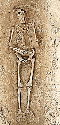 Femur: R-46 L-46.5 cm
Humerus: R-31.5 L-34 cm
Radius: R- 26.5 L-26.5 cm
Ulna: R-28 L-27.5 cm
Tibia: R-frag L- 39.5 cm
Fibula: R-frag L- 39 cm
Cranium: not taken
Pelvis (width): 31 cm
Entire length: 190 cm
Body Description:
Body position: Extended, supine
Directional orientation of the body: Head
at west, feet at east.
Position of hands: L-20 degrees, R-45 degrees at lower abdomen
(arms laid over unknown object placed on body)
Head position: Not raised
Grave Goods: None, but possible inadvertent pottery fragment in mouth
Overall State of Preservation: Grade 3 (95 % or greater)
Age determination estimation features:
Epiphyses fused: Yes
Deciduous teeth: No
Signs of osteoarthritis: No
Age Estimation: Old Adult (50+ yrs)
Cranial Sex determination observations:
Orbital shape: square
Orbital rim: blunt
Sub-orbital ridges: pronounced
Forehead: sloped
Mandible breadth: wide
Nuchal crest: rugged
Mastoid process: large
Mental eminence: pronounced
Possible Sex: Male
Additional comments/observations: Large adult male (190 cm in situ), located in possible martyrium in association with funerary chapel. Grave immediately north and adjacent to L-257, another probable adult grave. May be in association with Yoshmid stone (kayrak) marking double grave of Barshabba Kucha and Yoshmid the Priest. Cranial features dominated by large nasal bone; skeleton measured 190 cm in length (6'2") in grave. Taphonomy on skull, which contained no soil fill. Taphonomy throughout skeleton including right proximal humeral head, left distal femoral head, right tibia and fibula. Left thoracic cavity collapsed probably due to objected placed on the body at interment. Both arms wrapped around this object, which has deteriorated with no ability to discern as to what it is. Determined as Old Adult based on detention. Male based on pelvic and cranial indicators. Remains and floor of burial chamber at lowest elevation of all graves excavated to date. Head: 596.693; Pelvis: 596.504; Feet: 596.542 m. asl. Grave covered with two layers of mudbrick, a new sub-typology. Teeth samples taken.
Excavation year: 2023
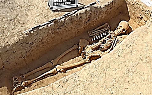 L-316 (Unit-15)
Measurements:
Femur: R 46 cm L 46 cm
Humerus: R 34 cm L 35 cm
Radius: R 26.5 cm L 27 cm
Ulna: R 28 cm L 28 cm
Tibia: R 39 cm L 39 cm
Fibula: R 38 L 38 cm
Cranium: not taken
Pelvis (width): 34 cm
Entire length: 173 cm
Body Description:
Body position: Extended, supine
Directional orientation of the body: Head at west, feet at east
Position of hands: Both hands 170-degrees up at clavicles.
Head position: Raised
Grave Goods: None
Overall State of Preservation: Grade 3 (95% or greater)
Age determination estimation features:
Epiphyses fused: yes
Deciduous teeth: no
Signs of osteoarthritis: yes
Age Estimation: Middle Adult (35-50 yrs.)
Cranial Sex determination observations:
Orbital shape: square
Orbital rim: blunt
Sub-orbital ridges: pronounced
Forehead: upright
Mandible breadth: wide
Nuchal crest: rugged
Mastoid process: large
Mental eminence: pronounced
Possible Sex: Male
Additional comments/observations: Grave had SW-NE orientation, which was off the normal axis. Several disarticulated bones found in the upper fill of the grave. Cranial and pelvic indicators are male. Bones are large and robust. Feet together suggest possible shroud or tying together of legs. Pelvic and cranial characteristics are male. Lower rt and lft PM-2 teeth samples taken. Soil samples taken. Skeletal Levels: Head: 597.101; Pelvis: 596.912; Feet: 596.914 m. asl.
Excavation Year: 2023
L-317 (Unit-15)
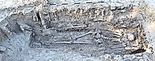
Measurements:
Femur: R damaged cm L 42 cm
Humerus: R 30 cm L 28.5 cm
Radius: R 22 cm L 22.3 cm
Ulna: R 25 cm L 23.5 cm
Tibia: R 33.5 cm L 34 cm
Fibula: R 33 cm L damaged cm
Cranium: not taken
Pelvis (width): 29 cm
Entire length: 163 cm
Body Description:
Body position: Extended, supine
Directional orientation of the body: Head at west, feet at east
Position of hands: Right prone along body, left across left ilium at 20 degrees.
Head position: Raised, gaze askance to south.
Grave Goods: Scissors discovered at right shoulder, silver loop earring, coin (silver) found in mouth.
Overall State of Preservation: Grade 3 (95% or greater)
Age determination estimation features:
Epiphyses fused: yes
Deciduous teeth: no
Signs of osteoarthritis: yes, lipping on L-5
Age Estimation: Middle Adult (35-50 yrs.)
Cranial Sex determination observations:
Orbital shape: round
Orbital rim: sharp
Sub-orbital ridges: unpronounced
Forehead: sloped
Mandible breadth: wide
Nuchal crest: smooth
Mastoid process: small
Mental eminence: triangular
Possible Sex: Female
Additional comments/observations: Wood framed structure lined tomb. Skull fractured postmortem with right orbit damaged under brushing during excavation. Metal fragments in soil may have been from nail from wood structure. Taphonomic damage to left clavicle and ulna, broken postmortem. Damage also on right and left ischia, possibly damaged by wooden structure collapse. Right femur also damaged postmortem(?). Right femur angled toward left, both legs close together possibly confined by wood structure. Both cranial and pelvic indicators are female. Dentition revealed wear consistent with a person closer to 50 yrs at time of death with wide disparity between maxilla, in which almost all teeth were missing prior to death and the mandible, in which almost all teeth were intact. Teeth and soil samples taken. Silver coin discovered in soil fill of mandible. Skeletal Levels: Field error, not taken.
Excavation Year: 2023
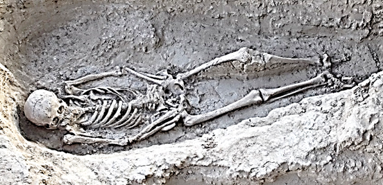 L-325 (Unit-15)
Measurements:
Femur: R 39 cm L 39 cm
Humerus: R 27 cm L 27 cm
Radius: R 22 cm L 22 cm
Ulna: R 24 cm L 23.5 cm
Tibia: R 33 cm L 33 cm
Fibula: R n/a L 31.5 cm
Cranium: 51cm (cir.)
Pelvis (width): 34 cm
Entire length: 150 cm
Body Description:
Body position: Extended, supine
Directional orientation of the body: Head at west, feet at east
Position of hands: Both hands at 25-degree angles over ilium of pelvis
Head position: Raised, gaze to southeast.
Grave Goods: None
Overall State of Preservation: Grade 3 (95% or greater)
Age determination estimation features:
Epiphyses fused: yes
Deciduous teeth: no
Signs of osteoarthritis: yes (L leg raised in grave, may have been impossible to place flat
premortem)
Age Estimation: Old Adult (50+ yrs.)
Cranial Sex determination observations:
Orbital shape: round
Orbital rim: sharp
Sub-orbital ridges: unpronounced
Forehead: upright
Mandible breadth: narrow
Nuchal crest: smooth
Mastoid process: small
Mental eminence: triangular
Possible Sex: Female
Additional comments/observations: Niche burial, with interment chamber to north. Left leg flexed at knee, may indicate pathological condition (arthritis?). Ribs of the right thoracic appeared to have shifted medially with the sternum laying on the left side of the thoracic region and seemingly caved in. The ribs easily fragmented, and the left thoracic region was more disheveled. The left clavicle also appeared slightly displaced and at a vertical position relative to the body. Hands appeared to be clasped over the abdomen with the arms at uniform 25-degree angles. Head was raised by a soil pillow, with the gaze to the southeast, possibly oriented to face the rising sun. Humerii had large tuberosities on the lateral midline. Left proximal humerus head highly worn likely due to arthritis. Maxilla displayed extreme atrophy, and while teeth from the upper maxilla were present in some cases, many appeared missing. Some had collapsed into the mandible and soil fill. Mandible exhibited signs of extensive bone reabsorption and atrophy with no teeth except for one 3rd molar. Skeletal Levels: Head: 597.050; Pelvis: 596.837; Feet: 596.812 m. asl.
Excavation Year: 2023
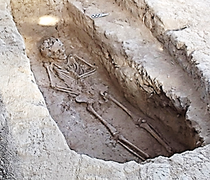 L-326 (Unit-15)
Measurements:
Femur: R 28.5 cm L 29.5 cm
Humerus: R 20 cm L 19 cm
Radius: R 14.5 cm L 14 cm
Ulna: R16 cm L 15.5 cm
Tibia: R 16 cm L 15.5 cm
Fibula: R 22 L 19 cm
Cranium: not taken
Pelvis (width): not taken
Entire length: 123 cm
Body Description:
Body position: Extended, supine
Directional orientation of the body: Head at west, feet at east
Position of hands: Right arm 25-degrees at pelvis,
Left arm 90-degree angle across upper abdomen.
Head position: Raised
Grave Goods: Yes, 2-3 glass paste beads near right wrist,
further fragments middle of left forearm between radius and ulna.
Overall State of Preservation: Grade 3 (95% or greater)
Age determination estimation features:
Epiphyses fused: no
Deciduous teeth: yes
Signs of osteoarthritis: no
Age Estimation: Child (3-12 yrs.)
Cranial Sex determination observations: N/A
Possible Sex: N/A
Additional comments/observations: Niche burial with interment chamber to south. Glass beads near right wrist indicate possible bracelet. Smaller breads at left forearm possible embroidery work. Evaluation of dentition suggest child of 10-12 yrs at time of death. Permanent incisors are shoveled indicating Asian ethnicity. Rt. radius fractured postmortem as were lft radius and ulna. Parts of parietal and frontal lobes collapsed upon itself. Pelvic ischia both deteriorated and left pubic bone fractured from rest of pelvis, but all remains intact in and good condition. Skeletal levels: Head: 597.075; Pelvis: 596.943; Feet: 597.948 m. asl.
Excavation Year: 2023
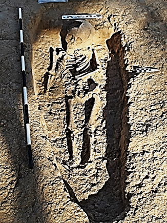 L-328 (Unit-15)
Measurements:
Femur: R 18.5 cm L 19 cm
Humerus: R 14.5 cm L 14.5 cm
Radius: R 11 cm L 11 cm
Ulna: R damaged cm L 12 cm
Tibia: R damaged cm L 18.5 cm
Fibula: not present
Cranium: 13.4 dia. 47 cir.
Body Description:
Body position: Extended, supine
Directional orientation of the body: Head at west, feet
at east
Position of hands: Right prone alongside body, Left 80 degrees across upper abdomen.
Head position: Raised, gaze east/southeast
Grave Goods: None
Overall State of Preservation: Grade 3 (95% or greater)
Age determination estimation features:
Epiphyses fused: no
Deciduous teeth: yes
Signs of osteoarthritis: no
Age Estimation: Child (3-12 yrs.)
Cranial Sex determination observations: N/A
Possible Sex: N/A
Additional comments/observations: Discovered when skull as overrun by wheelbarrow, this damaged right parietal bone. Dentition and size suggest sub-adult 4-5 yrs old since all deciduous teeth had erupted. Overall, remains complete, but taphonomy in lower appendicular skeleton, most foot phalanges missing. Skeletal Levels: Head: 597.345; Pelvis: 597.208; Feet: 597.213 m. asl.
Excavation Year: 2023
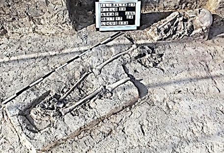 L-354 (Unit-17)
Measurements:
Femur: R 39.5 cm L missing
Humerus: R18.5 cm L missing
Radius: missing
Ulna: R damaged L missing
Tibia: R missing L 32 cm
Fibula: R 31 cm L 32 cm
Cranium: 49 (cir.)
Pelvis (width): damaged
Entire length: 148 cm
Body Description:
Body position: Extended, supine
Directional orientation of the body: Head at west, feet at east.
Position of hands: Indeterminate (missing)
Head position: Not raised, gaze to south.
Grave Goods: None
Overall State of Preservation: Grade 2 (60% - 30%)
Age determination estimation features:
Epiphyses fused: Yes
Deciduous teeth: No
Signs of osteoarthritis: No
Age Estimation: Young Adult (20-35 yrs)
Cranial Sex determination observations:
Orbital shape: round
Orbital rim: sharp
Sub-orbital ridges: pronounced
Forehead: upright
Mandible breadth: narrow
Nuchal crest: smooth
Mastoid process: small
Mental eminence: triangular
Possible Sex: Female
Additional comments/observations:
Remains damaged by mechanical excavation. Right side of the upper axial skeleton (ribs 1-9) intact. Right clavicle and humerus also intact, however, the right ulna was in an inverted position and lay between the right humerus and thoracic cavity. All the left thoracic area downward missing downward with only 20 cm of the left femur’s distal end remaining in situ. Entire left pelvis missing as was right tibia and left fibula. None of left appendicular skeleton present, nor right radius. All the appendages (hands and feet) missing except for some of the metacarpals, yet both tali intact. Feet placed parallel and adjacent to one another, suggesting a possible binding of the legs at time of burial. Small, light-blue glazed potsherd discovered north of the remaining metatarsals. Right mandible bifurcated close to mental eminence and detached completely. Mandible appeared to have a parasymphyseal fracture on the right side, suggesting premortem break since the lower right P1 and P2 molars had somehow shifted and were adhering to the outer mandible wall. The dental alveoli for these lower right P1 and P2 appeared to have bone growth, which indicate some unusual injury that shifted the teeth to the position anterior to the lower right M1 molar. Teeth samples taken. Levels: Head: 597.456; Pelvis (damaged): 597.264; Feet: 597.353 m. asl.
Excavation year: 2023
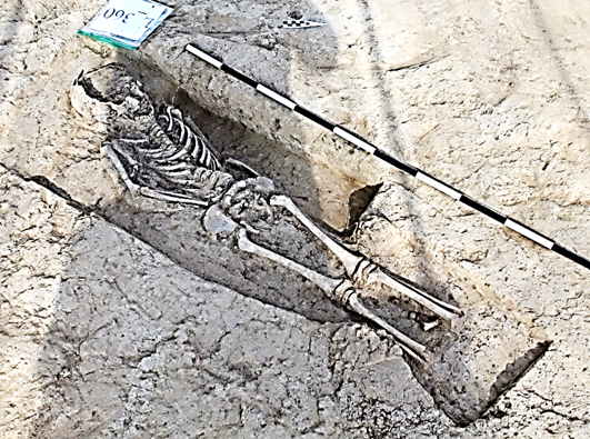 L-360 (Unit-17)
Measurements:
Femur: R 22 cm L 22 cm
Humerus: R 16 cm L 15 cm
Radius: R 12.5 cm L missing
Ulna: R 14 cm L 14 cm
Tibia: R 19 cm L19 cm
Fibula: R 17.2 L 17.7 cm
Cranium: 15 cm (dia.) 45 cm (circ.)
Pelvis (width): 19 cm
Entire length: 96 cm
Body Description:
Body position: Extended, supine
Directional orientation of the body: Head at west, feet at east.
Position of hands: Left, prone, lateral to body. Right, 25 degrees over abdomen.
Head position: Raised
Grave Goods: None
Overall State of Preservation: Grade 1 (95 % or greater)
Age determination estimation features:
Epiphyses fused: No
Deciduous teeth: Yes
Signs of osteoarthritis: No
Age Estimation: Child (3-12 yrs)
Cranial Sex determination observations: N/A
Possible Sex: N/A
Additional comments/observations: Cranium struck by shovel during initial excavation, otherwise all remains intact. Grave pit has more southwest-to -northeast orientation as opposed to cardinal east-west orientation. Grave seems close enough to the neighboring U-15 graves it can be considered part of the cluster of graves with this type of orientation. Right hand was positioned on the abdomen and just below the thoracic cavity. The left arm, slightly lower depth soil due to the tilt of the body, appeared to be prone and lateral to the body. Later examination confirmed that the left hand was slightly under left pelvis. Despite damage to cranium, evident head had been raised with a small “pillow” of soil. Epiphyses of the lower legs clearly visible between the tibiae and fibulae. Lower mandible intact with only part of maxilla due to the shovel strike. Teeth, following a cursory examination, showed that that the lower incisors (I-1 and I-2) are permanent, not deciduous teeth, which would put the approximate age at time of death approximately 6-7 years old. The rib cage along with vertebrae were fully intact. Skeletal levels measured as follows: Head: 597.335; Pelvis: 596.261; Feet: 597.262 m. asl.
Excavation year: 2023
L-368 (Unit-17)
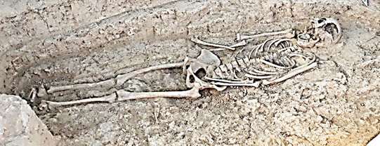
Measurements:
Femur: R 40 cm L 40 cm
Humerus: R 39.5 cm L 39 cm
Radius: R 21.5 cm L 21.5 cm
Ulna: R 23 cm L 23.5 cm
Tibia: R 33.5 cm L 33.5 cm
Fibula: R31.5 L 30 cm
Cranium: damaged
Pelvis (width): 32 cm
Entire length: 157 cm
Body Description:
Body position: Extended, supine
Directional orientation of the body: Head at west, feet at east
Position of hands: R arm prone along body, L across left ilium at 15-degree angle
Head position: Not raised
Grave Goods: None
Overall State of Preservation: Grade 1 (95 % or greater)
Age determination estimation features:
Epiphyses fused: Yes
Deciduous teeth: Yes
Signs of osteoarthritis: No
Age Estimation: Middle Adult (35-50 yrs)
Cranial Sex determination observations:
Orbital shape: square
Orbital rim: sharp
Sub-orbital ridges: unpronounced
Forehead: upright
Mandible breadth: wide
Nuchal crest: unobserved
Mastoid process: small
Mental eminence: triangular
Possible Sex: Female
Additional comments/observations:
Remains within a niche grave (Type 4). Adult skeleton in excellent condition, however, major damage due to a shovel strike to left side of cranium during excavation. Based on position of right radius, right arm was placed prone, laterally to the body. Left arm placed across left ilium of pelvis at a 15-degree angle. Head not intentionally raised, mouth was agape with mandible resting on cervical vertebrae. Both cranial and pelvic features indicate that remains are an adult female. Detention suggests time of death in late 30’s or early 40s. Fused sacrum supports death after 35 years. Mandibular teeth all present, moderate wear. Maxillary teeth were present, except for the upper right M-1 and M-3 with alveoli evidence of bone regrowth, indicating premortem loss. Dental caries noted on the upper right M-2, on the anterior side, and the lateral side of the lower right M-3. Upper left I-1 and I-2 which were missing post-mortem and not detected in the soil. Skeletal levels: Head: 597.178; Pelvis: 597.028; Feet: 596.962 m. asl.
Excavation Year: 2023
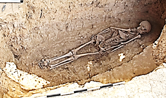 L-373 (Unit-17)
Measurements:
Femur: R 40.5 cm L 41.5 cm
Humerus: R 29.8 cm L 31 cm
Radius: R 22.3 cm L 22 cm
Ulna: R 24.5 cm L 24.5 cm
Tibia: R 33.2 cm L 33 cm
Fibula: R 31.9 L 32.5 cm
Cranium: not taken
Pelvis (width): 30.5 cm
Entire length: 162 cm
Body Description:
Body position: Extended, supine
Directional orientation of the body: Head at west, feet at east
Position of hands: Both arms prone along body, left hand possibly on top of spreadhead and small dagger.
Head position: Raised
Grave Goods: Yes, metal fragments throughout grave and around head, possibly in connection with
clothing. 3 arrow or spearheads, 1 small dagger.
Overall State of Preservation: Grade 3 (95% or greater)
Age determination estimation features:
Epiphyses fused: No, sacrum not fully fused.
Deciduous teeth: No
Signs of osteoarthritis: No
Age Estimation: Young Adult (20-35 yrs.)
Cranial Sex determination observations:
Orbital shape: round
Orbital rim: sharp
Sub-orbital ridges: unpronounced
Forehead: upright
Mandible breadth: wide
Nuchal crest: smooth
Mastoid process: small
Mental eminence: pronounced
Possible Sex: Male
Additional comments/observations: Body extended and supine, however, right scapula, clavicle and humerus displaced across thoracic region, suggesting possible rigor mortis at time of burial. Left hand possibly placed on top spreadhead and small dagger. Legs joined beginning at the knees, extending to the feet, suggesting legs possibly bound at time of interment. The left tibia had a large, complete post-mortem fracture on the distal side of the bone. Head, while facing north, may have been slightly raised. All bones fused with exception of partially fused sacrum. All teeth present, dentition had only slight wear, All the incisors were clearly shoveled, strongly suggesting Asian heritage. The skull indicators mixed as to sex determination, but pelvic indicators clearly indicate male. Head: 596.835; Pelvis: 596.603; Feet: 596.628 m. asl.
Excavation Year: 2023
Appendix. Master Locus Sheet
|
||||||||||||||||||||||||||||||||||||||||||||||||||||||||||||||||||||||||||||||||||||||||||||||||||||||||||||||||||||||||||||||||||||||||||||||||||||||||||||||||||||||||||||||||||||||||||||||||||||
Appendix. Finds Inventory |
||||||||||||||||||||||||||||||||||||||||||||||||||||||||||||||||||||||||||||||||||||||||||||||||||||||||||||||||||||||||||||||||||||||||||||||||||||||||||||||||||||||||||||||||||||||||||||||||||||
|
||||||||||||||||||||||||||||||||||||||||||||||||||||||||||||||||||||||||||||||||||||||||||||||||||||||||||||||||||||||||||||||||||||||||||||||||||||||||||||||||||||||||||||||||||||||||||||||||||||
Appendix. The description of ceramic findsIntact and halfway preserved unglazed ceramic vessels. |
||||||||||||||||||||||||||||||||||||||||||||||||||||||||||||||||||||||||||||||||||||||||||||||||||||||||||||||||||||||||||||||||||||||||||||||||||||||||||||||||||||||||||||||||||||||||||||||||||||
|
||||||||||||||||||||||||||||||||||||||||||||||||||||||||||||||||||||||||||||||||||||||||||||||||||||||||||||||||||||||||||||||||||||||||||||||||||||||||||||||||||||||||||||||||||||||||||||||||||||
A large disc-shaped lid was also found, made from a medium-kneaded dense fabric of red color with yellow-beige tint, with multiple inclusions of small and large sand particles and white colored inclusions visible in the fracture. The surface of the lid is covered with either a light engobe, or with a fabric of the same color but a more liquid consistency as the artifact itself. The lid at the top has several lines indented with fingers, the diameter of the lid is 17 cm, the thickness of the lid is 5 cm, the edges of the lid are not worked, dints and ruts are visible in some areas.
|
||||||||||||||||||||||||||||||||||||||||||||||||||||||||||||||||||||||||||||||||||||||||||||||||||||||||||||||||||||||||||||||||||||||||||||||||||||||||||||||||||||||||||||||||||||||||||||||||||||
A four-spouted chirag-lamp has been found in-situ, made from well-kneaded dense fabric of a light red color with an orange-beige tint, with minor inclusions of small sand particles visible in the fracture. The surface is covered with a light engobe on the exterior and partially on the inerior (namely the interior surface of the spouts); the lamp has a form of a closed dome-shaped reservoir with spouts extending from the sides, two of which are not preserved. A nail-shaped knob on a low stem is affixed at the top center of the reservoir, the height of the knob is 3.5 cm, the diameter of its upper part is 4.6 cm, the thickness of the knob cap is 2.3 cm, the shoulders of the reservoir are gently sloped, the walls expand in the central part and sharply narrow towards a flat disc-shaped base with a diameter of 7.7 cm and a height of 1.1 cm. The spouts are slightly raised upward, their length from the baseline is 7.8 cm, width at the baseline is 4.7 cm, height 3.4 cm. The total height of the lamp is 13.9 cm, the diameter of the reservoir is 16.5 cm, the walls of the reservoir are 0.7-1.4 cm thick. |
||||||||||||||||||||||||||||||||||||||||||||||||||||||||||||||||||||||||||||||||||||||||||||||||||||||||||||||||||||||||||||||||||||||||||||||||||||||||||||||||||||||||||||||||||||||||||||||||||||
A four-spouted chirag-lamp has been found in-situ, with a part of its reservoir and two spouts not preserved, made from a well-kneaded dense fabric of red color with pinkish-beige tint, with minor inclusions of small sand particles and mica visible in the fracture. The surface is covered with a light engobe on the exterior and partially on the inerior (namely the interior surface of the spouts). The top of the chirag is crowned with a molded ridge with a diameter of 6.6 cm and thickness of 0.7 cm decorated with alternating impressions. The molded vertical tube at the center of the reservoir is broken off at the top, the ridge is affixed to the top of reservoir. The upper part of the reservoir has a sphero-conical shape and is flattened at the bottom, a part of the reservoir wall and two spouts are lost. One spout is fully preserved, all the edges and walls of the spouts retain traces of calcination and soot from exposure to fire. The spouts are elongated, subsquare in cross-section, wide at the point of attachment to the outside of wall of the reservoir, they narrow towards the tip and slightly curl up; the length of the preserved spout from its base to the tip is 7.2 cm. The base-ring is flat, 7.5 cm in diameter, and has a through hole at the center with a diameter of 1.9 cm formed by the tube. The height of the lamp is 12 cm, the diameter of the chirag reservoir is 16.5 cm, the walls of the reservoir are 0.7-1.4 cm thick. The height of the cylindrical tube from the bottom of the reservoir to the point of its attachment to the reservoir top is 8 cm. The tube is 4 cm narrow at the top and widens towards the base to 5.3 cm.
|
||||||||||||||||||||||||||||||||||||||||||||||||||||||||||||||||||||||||||||||||||||||||||||||||||||||||||||||||||||||||||||||||||||||||||||||||||||||||||||||||||||||||||||||||||||||||||||||||||||
Unglazed fragments of ceramic vessels and objects.
|
||||||||||||||||||||||||||||||||||||||||||||||||||||||||||||||||||||||||||||||||||||||||||||||||||||||||||||||||||||||||||||||||||||||||||||||||||||||||||||||||||||||||||||||||||||||||||||||||||||
A fragment of a rim of a large khumcha-type vessel was found made from a well-kneaded dense fabric of red color with orange-white tint with minor inclusions of small and large sand particles and white colored inclusions visible in the fracture. The exterior and partially the interior surfaces of the fragment are covered with a thick layer of white engobe. The rim with a thickened edge bent outwards, subrectangular in cross-section, forms a 3.7 cm wide platform beveled inwards with a break, the thickness of the edge is 1.1 cm. The exterior surface of the platform has a stamped decoration in a form of six-leaved flowers arranged in small alternating lines. The neck of the vessel sharply turns into a sloping shoulder, the diameter of the rim along the outer edge is 38 cm, along the inner edge 31 cm, the thickness of the vessel walls is 1.1-1.3 cm.
|
||||||||||||||||||||||||||||||||||||||||||||||||||||||||||||||||||||||||||||||||||||||||||||||||||||||||||||||||||||||||||||||||||||||||||||||||||||||||||||||||||||||||||||||||||||||||||||||||||||
A fragment of a ceramic vessel with a flat base and a sidewall, presumably of a jug, was also discovered, made from a well-kneaded dense fabric of red color with orange-beige tint, with minor inclusions of small sand particles and small cracks visible in the fractures. The exterior surface of the fragment is covered with a layer of light, almost white engobe, traces of soot and blackened burn marks from severe calcination are also visible, as well as a combed decoration in the form of concentric wavy lines drawn in several rows horizontally on the upper part of the vessel’s body. The base of the vessel is 11.5 cm in diameter, the thickness of the base is 0.7-1 cm, the thickness of the sidewalls is 0.8-0.9 cm.
|
||||||||||||||||||||||||||||||||||||||||||||||||||||||||||||||||||||||||||||||||||||||||||||||||||||||||||||||||||||||||||||||||||||||||||||||||||||||||||||||||||||||||||||||||||||||||||||||||||||
Glazed fragments of ceramic vessels and objects. A small fragment of a sidewall of a thin-walled vessel was also found, made from well-kneaded dense fabric of a yellow-beige color, with no visible inclusions. The interior surface of a fragment is covered with a layer of transparent orange-brown glaze interspersed with dark color; the exterior surface is covered with a layer of yellow glaze with dark speckles; the ornamentation is absent. The thickness of the sidewall is 0.4 cm. |
||||||||||||||||||||||||||||||||||||||||||||||||||||||||||||||||||||||||||||||||||||||||||||||||||||||||||||||||||||||||||||||||||||||||||||||||||||||||||||||||||||||||||||||||||||||||||||||||||||
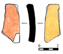 Figure 11. Ib_23_C_IV_343_I002 |
||||||||||||||||||||||||||||||||||||||||||||||||||||||||||||||||||||||||||||||||||||||||||||||||||||||||||||||||||||||||||||||||||||||||||||||||||||||||||||||||||||||||||||||||||||||||||||||||||||
Fragments of metal artefacts |
||||||||||||||||||||||||||||||||||||||||||||||||||||||||||||||||||||||||||||||||||||||||||||||||||||||||||||||||||||||||||||||||||||||||||||||||||||||||||||||||||||||||||||||||||||||||||||||||||||
Fragments of bone artefacts
|
||||||||||||||||||||||||||||||||||||||||||||||||||||||||||||||||||||||||||||||||||||||||||||||||||||||||||||||||||||||||||||||||||||||||||||||||||||||||||||||||||||||||||||||||||||||||||||||||||||
A bead A stone |
||||||||||||||||||||||||||||||||||||||||||||||||||||||||||||||||||||||||||||||||||||||||||||||||||||||||||||||||||||||||||||||||||||||||||||||||||||||||||||||||||||||||||||||||||||||||||||||||||||
A Coin Figure 21. Ib_22_С_IV_317_I003 |
||||||||||||||||||||||||||||||||||||||||||||||||||||||||||||||||||||||||||||||||||||||||||||||||||||||||||||||||||||||||||||||||||||||||||||||||||||||||||||||||||||||||||||||||||||||||||||||||||||
| Appendix. Drawing documentation | ||||||||||||||||||||||||||||||||||||||||||||||||||||||||||||||||||||||||||||||||||||||||||||||||||||||||||||||||||||||||||||||||||||||||||||||||||||||||||||||||||||||||||||||||||||||||||||||||||||
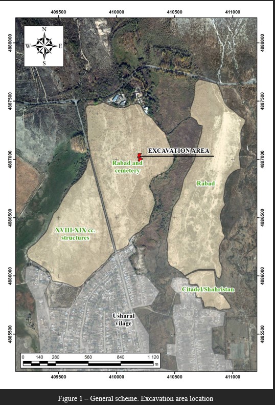 |
||||||||||||||||||||||||||||||||||||||||||||||||||||||||||||||||||||||||||||||||||||||||||||||||||||||||||||||||||||||||||||||||||||||||||||||||||||||||||||||||||||||||||||||||||||||||||||||||||||
 |
||||||||||||||||||||||||||||||||||||||||||||||||||||||||||||||||||||||||||||||||||||||||||||||||||||||||||||||||||||||||||||||||||||||||||||||||||||||||||||||||||||||||||||||||||||||||||||||||||||
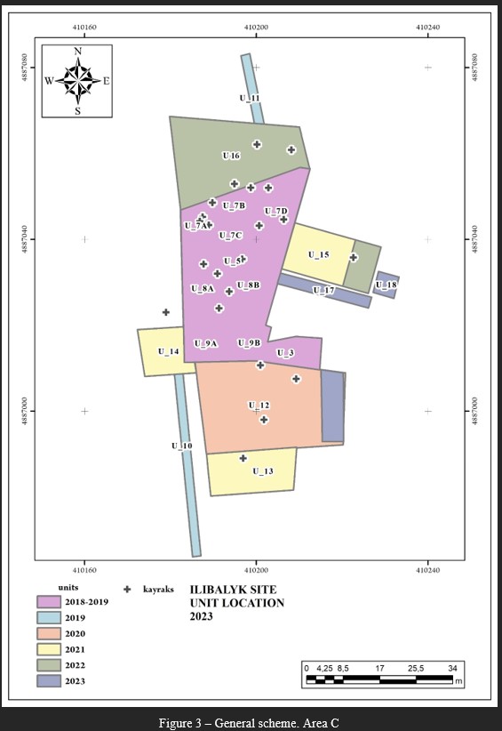 |
||||||||||||||||||||||||||||||||||||||||||||||||||||||||||||||||||||||||||||||||||||||||||||||||||||||||||||||||||||||||||||||||||||||||||||||||||||||||||||||||||||||||||||||||||||||||||||||||||||
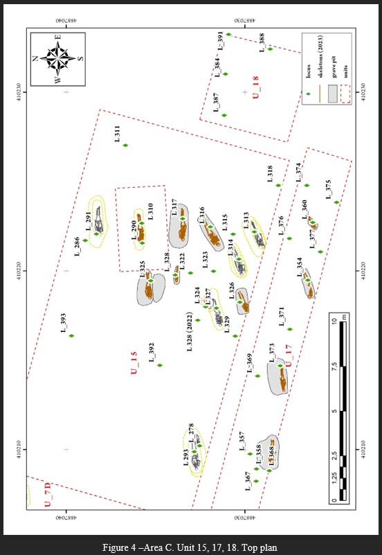 |
||||||||||||||||||||||||||||||||||||||||||||||||||||||||||||||||||||||||||||||||||||||||||||||||||||||||||||||||||||||||||||||||||||||||||||||||||||||||||||||||||||||||||||||||||||||||||||||||||||
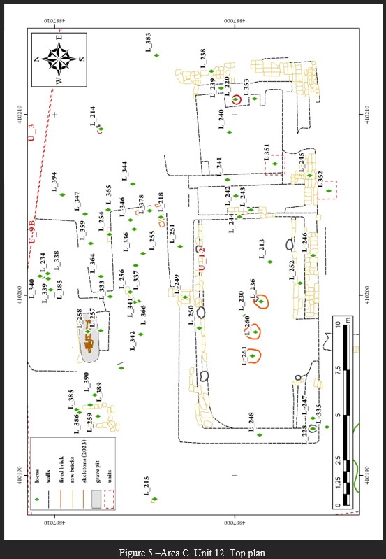 |
||||||||||||||||||||||||||||||||||||||||||||||||||||||||||||||||||||||||||||||||||||||||||||||||||||||||||||||||||||||||||||||||||||||||||||||||||||||||||||||||||||||||||||||||||||||||||||||||||||
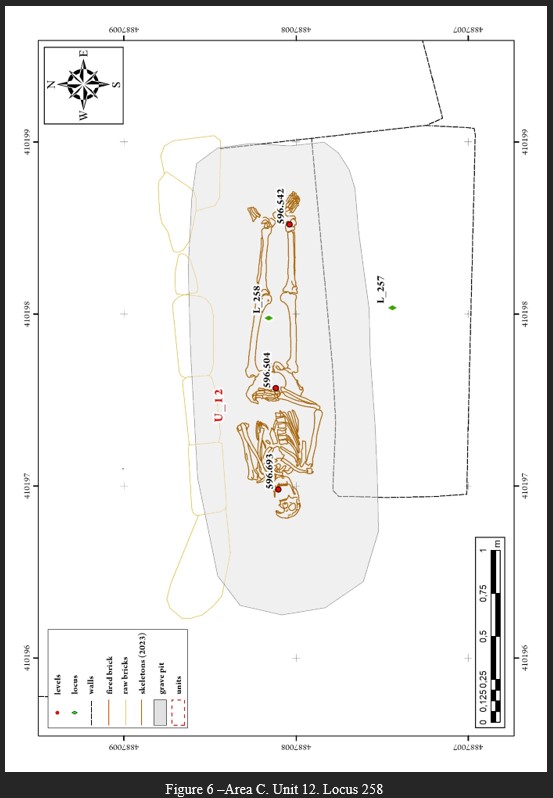 |
||||||||||||||||||||||||||||||||||||||||||||||||||||||||||||||||||||||||||||||||||||||||||||||||||||||||||||||||||||||||||||||||||||||||||||||||||||||||||||||||||||||||||||||||||||||||||||||||||||
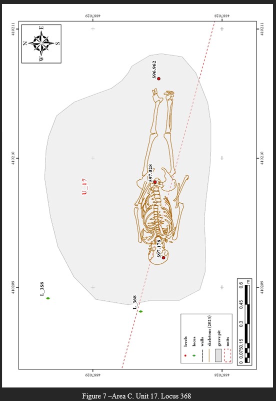 |
||||||||||||||||||||||||||||||||||||||||||||||||||||||||||||||||||||||||||||||||||||||||||||||||||||||||||||||||||||||||||||||||||||||||||||||||||||||||||||||||||||||||||||||||||||||||||||||||||||
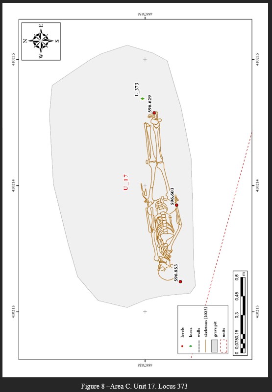 |
||||||||||||||||||||||||||||||||||||||||||||||||||||||||||||||||||||||||||||||||||||||||||||||||||||||||||||||||||||||||||||||||||||||||||||||||||||||||||||||||||||||||||||||||||||||||||||||||||||
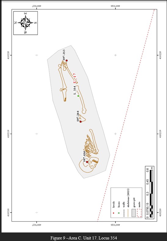 |
||||||||||||||||||||||||||||||||||||||||||||||||||||||||||||||||||||||||||||||||||||||||||||||||||||||||||||||||||||||||||||||||||||||||||||||||||||||||||||||||||||||||||||||||||||||||||||||||||||
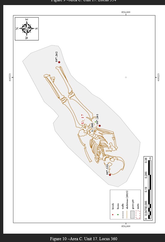 |
||||||||||||||||||||||||||||||||||||||||||||||||||||||||||||||||||||||||||||||||||||||||||||||||||||||||||||||||||||||||||||||||||||||||||||||||||||||||||||||||||||||||||||||||||||||||||||||||||||
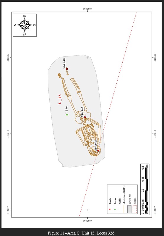 |
||||||||||||||||||||||||||||||||||||||||||||||||||||||||||||||||||||||||||||||||||||||||||||||||||||||||||||||||||||||||||||||||||||||||||||||||||||||||||||||||||||||||||||||||||||||||||||||||||||
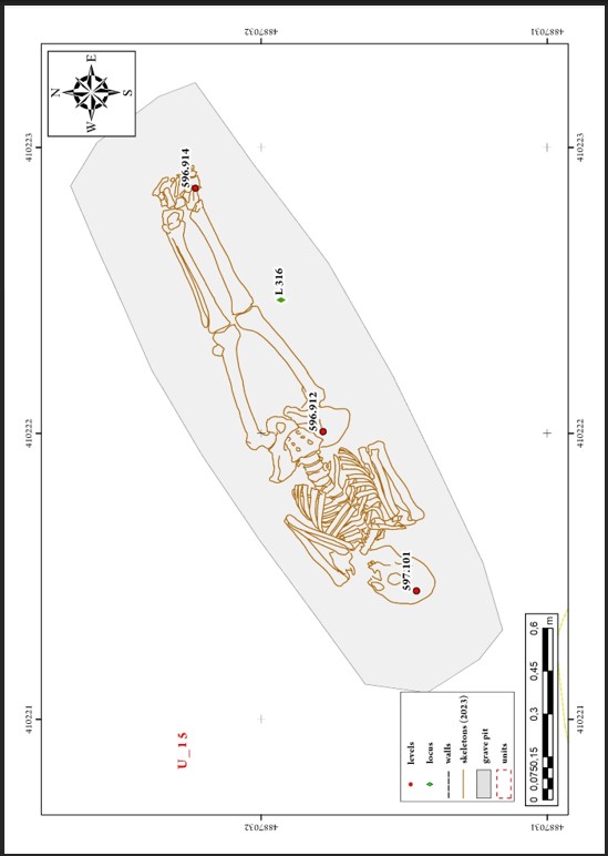 |
||||||||||||||||||||||||||||||||||||||||||||||||||||||||||||||||||||||||||||||||||||||||||||||||||||||||||||||||||||||||||||||||||||||||||||||||||||||||||||||||||||||||||||||||||||||||||||||||||||
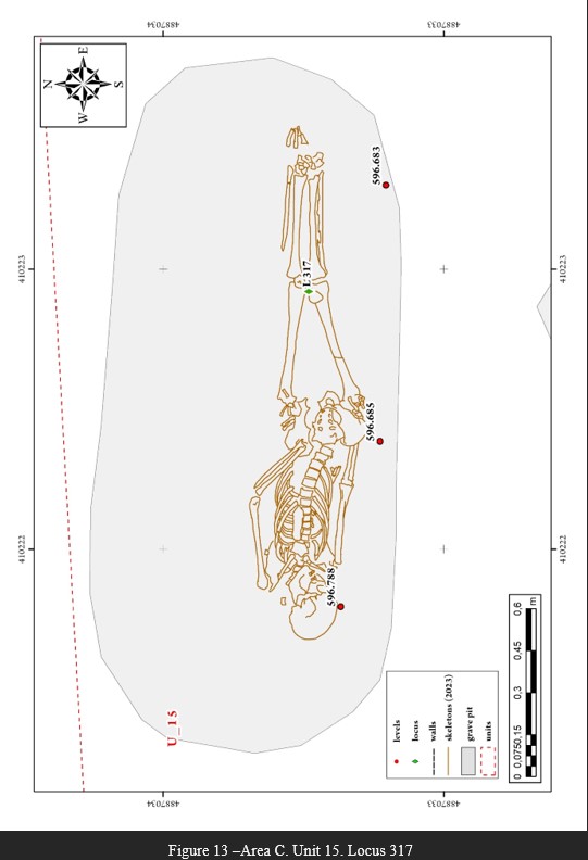 |
||||||||||||||||||||||||||||||||||||||||||||||||||||||||||||||||||||||||||||||||||||||||||||||||||||||||||||||||||||||||||||||||||||||||||||||||||||||||||||||||||||||||||||||||||||||||||||||||||||
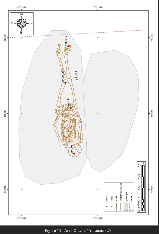 |
||||||||||||||||||||||||||||||||||||||||||||||||||||||||||||||||||||||||||||||||||||||||||||||||||||||||||||||||||||||||||||||||||||||||||||||||||||||||||||||||||||||||||||||||||||||||||||||||||||
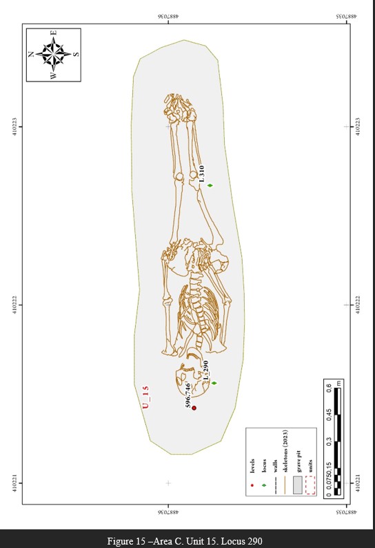 |
||||||||||||||||||||||||||||||||||||||||||||||||||||||||||||||||||||||||||||||||||||||||||||||||||||||||||||||||||||||||||||||||||||||||||||||||||||||||||||||||||||||||||||||||||||||||||||||||||||
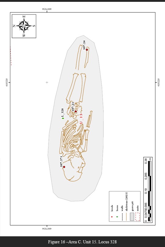 |
||||||||||||||||||||||||||||||||||||||||||||||||||||||||||||||||||||||||||||||||||||||||||||||||||||||||||||||||||||||||||||||||||||||||||||||||||||||||||||||||||||||||||||||||||||||||||||||||||||
Appendix. Photos |
||||||||||||||||||||||||||||||||||||||||||||||||||||||||||||||||||||||||||||||||||||||||||||||||||||||||||||||||||||||||||||||||||||||||||||||||||||||||||||||||||||||||||||||||||||||||||||||||||||
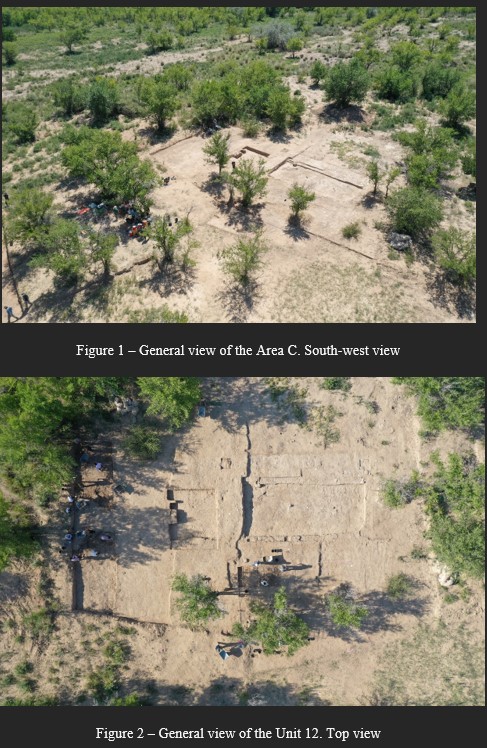 |
||||||||||||||||||||||||||||||||||||||||||||||||||||||||||||||||||||||||||||||||||||||||||||||||||||||||||||||||||||||||||||||||||||||||||||||||||||||||||||||||||||||||||||||||||||||||||||||||||||
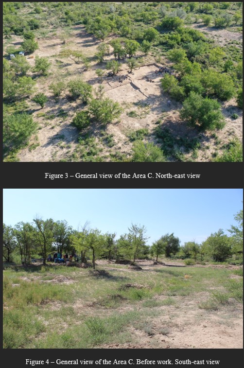 |
||||||||||||||||||||||||||||||||||||||||||||||||||||||||||||||||||||||||||||||||||||||||||||||||||||||||||||||||||||||||||||||||||||||||||||||||||||||||||||||||||||||||||||||||||||||||||||||||||||
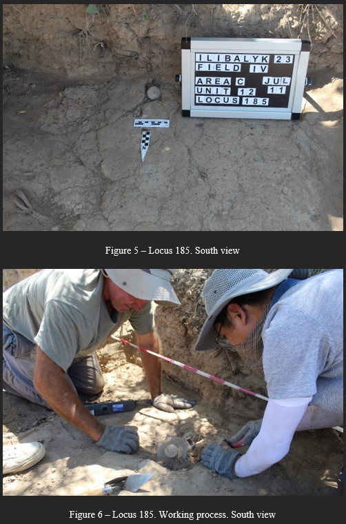 |
||||||||||||||||||||||||||||||||||||||||||||||||||||||||||||||||||||||||||||||||||||||||||||||||||||||||||||||||||||||||||||||||||||||||||||||||||||||||||||||||||||||||||||||||||||||||||||||||||||
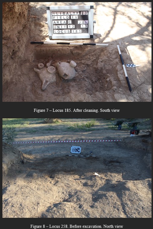 |
||||||||||||||||||||||||||||||||||||||||||||||||||||||||||||||||||||||||||||||||||||||||||||||||||||||||||||||||||||||||||||||||||||||||||||||||||||||||||||||||||||||||||||||||||||||||||||||||||||
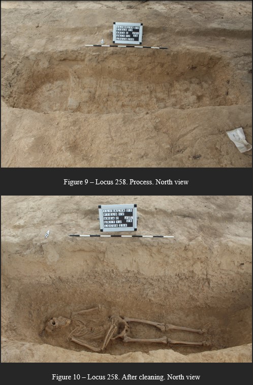 |
||||||||||||||||||||||||||||||||||||||||||||||||||||||||||||||||||||||||||||||||||||||||||||||||||||||||||||||||||||||||||||||||||||||||||||||||||||||||||||||||||||||||||||||||||||||||||||||||||||
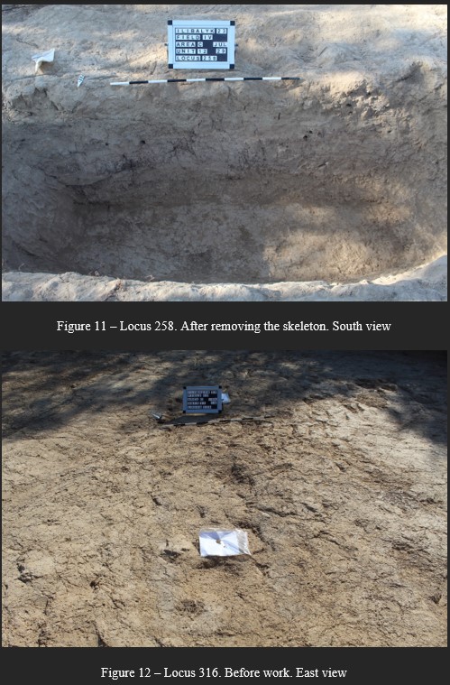 |
||||||||||||||||||||||||||||||||||||||||||||||||||||||||||||||||||||||||||||||||||||||||||||||||||||||||||||||||||||||||||||||||||||||||||||||||||||||||||||||||||||||||||||||||||||||||||||||||||||
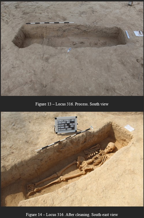 |
||||||||||||||||||||||||||||||||||||||||||||||||||||||||||||||||||||||||||||||||||||||||||||||||||||||||||||||||||||||||||||||||||||||||||||||||||||||||||||||||||||||||||||||||||||||||||||||||||||
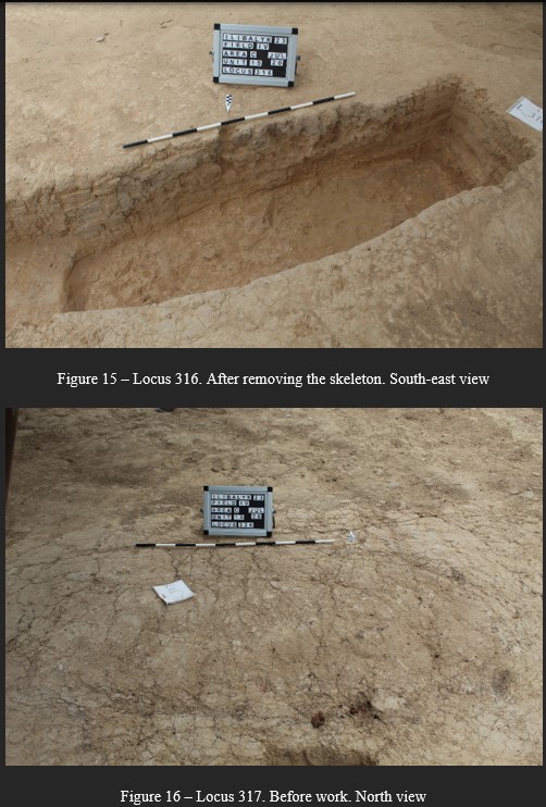 |
||||||||||||||||||||||||||||||||||||||||||||||||||||||||||||||||||||||||||||||||||||||||||||||||||||||||||||||||||||||||||||||||||||||||||||||||||||||||||||||||||||||||||||||||||||||||||||||||||||
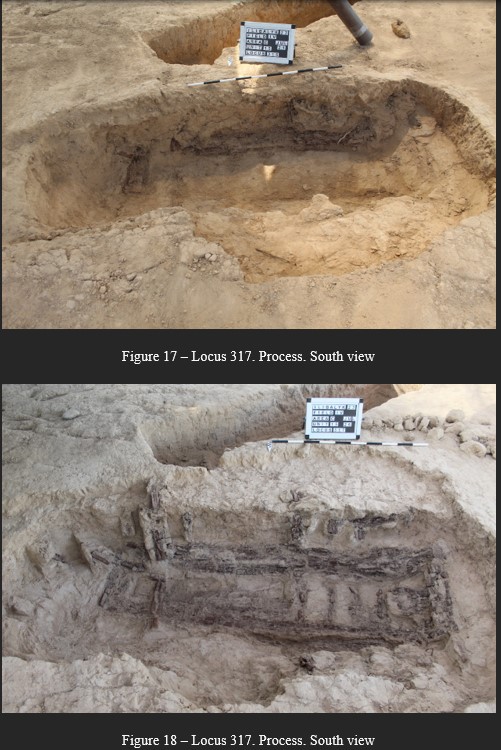 |
||||||||||||||||||||||||||||||||||||||||||||||||||||||||||||||||||||||||||||||||||||||||||||||||||||||||||||||||||||||||||||||||||||||||||||||||||||||||||||||||||||||||||||||||||||||||||||||||||||
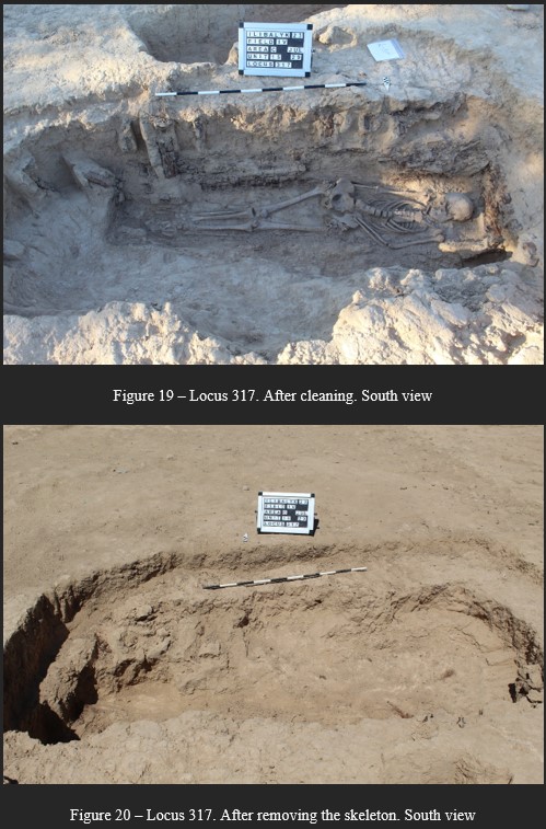 |
||||||||||||||||||||||||||||||||||||||||||||||||||||||||||||||||||||||||||||||||||||||||||||||||||||||||||||||||||||||||||||||||||||||||||||||||||||||||||||||||||||||||||||||||||||||||||||||||||||
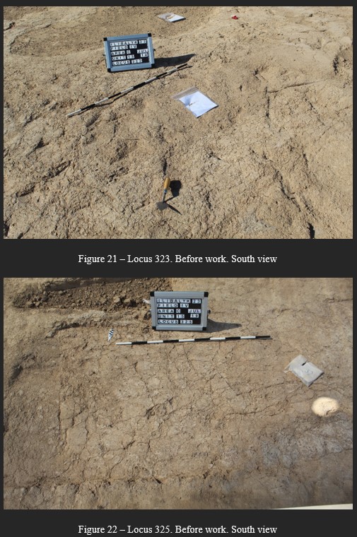 |
||||||||||||||||||||||||||||||||||||||||||||||||||||||||||||||||||||||||||||||||||||||||||||||||||||||||||||||||||||||||||||||||||||||||||||||||||||||||||||||||||||||||||||||||||||||||||||||||||||
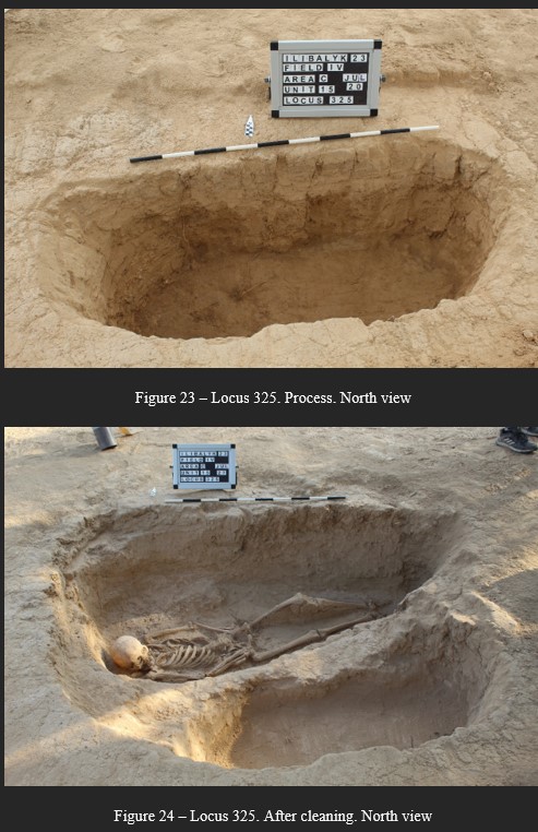 |
||||||||||||||||||||||||||||||||||||||||||||||||||||||||||||||||||||||||||||||||||||||||||||||||||||||||||||||||||||||||||||||||||||||||||||||||||||||||||||||||||||||||||||||||||||||||||||||||||||
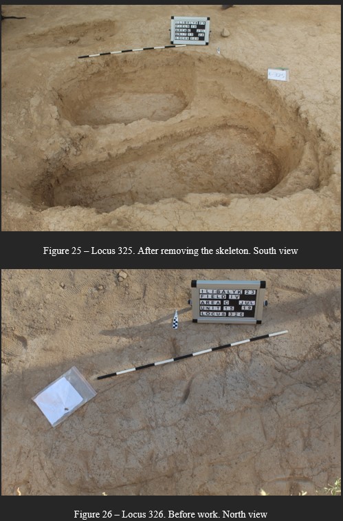 |
||||||||||||||||||||||||||||||||||||||||||||||||||||||||||||||||||||||||||||||||||||||||||||||||||||||||||||||||||||||||||||||||||||||||||||||||||||||||||||||||||||||||||||||||||||||||||||||||||||
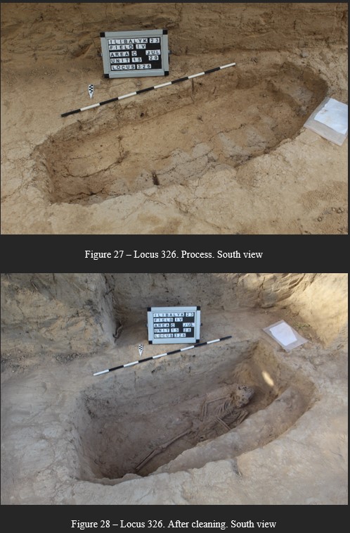 |
||||||||||||||||||||||||||||||||||||||||||||||||||||||||||||||||||||||||||||||||||||||||||||||||||||||||||||||||||||||||||||||||||||||||||||||||||||||||||||||||||||||||||||||||||||||||||||||||||||
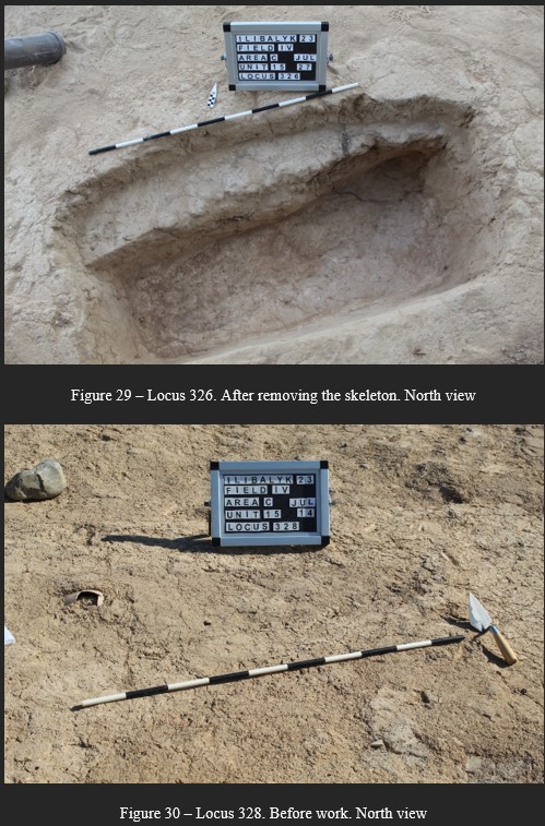 |
||||||||||||||||||||||||||||||||||||||||||||||||||||||||||||||||||||||||||||||||||||||||||||||||||||||||||||||||||||||||||||||||||||||||||||||||||||||||||||||||||||||||||||||||||||||||||||||||||||
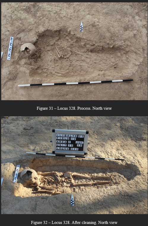 |
||||||||||||||||||||||||||||||||||||||||||||||||||||||||||||||||||||||||||||||||||||||||||||||||||||||||||||||||||||||||||||||||||||||||||||||||||||||||||||||||||||||||||||||||||||||||||||||||||||
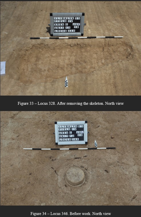 |
||||||||||||||||||||||||||||||||||||||||||||||||||||||||||||||||||||||||||||||||||||||||||||||||||||||||||||||||||||||||||||||||||||||||||||||||||||||||||||||||||||||||||||||||||||||||||||||||||||
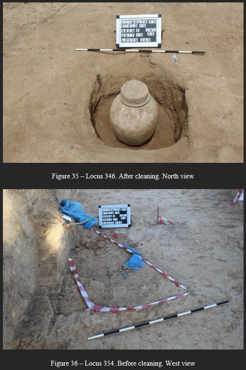 |
||||||||||||||||||||||||||||||||||||||||||||||||||||||||||||||||||||||||||||||||||||||||||||||||||||||||||||||||||||||||||||||||||||||||||||||||||||||||||||||||||||||||||||||||||||||||||||||||||||
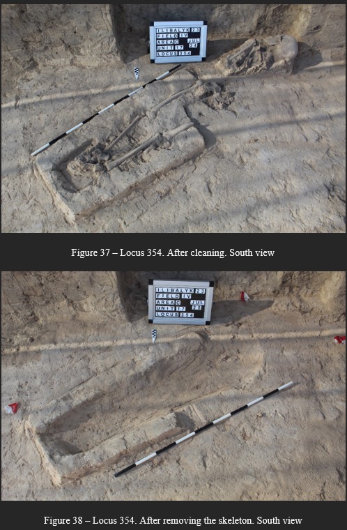 |
||||||||||||||||||||||||||||||||||||||||||||||||||||||||||||||||||||||||||||||||||||||||||||||||||||||||||||||||||||||||||||||||||||||||||||||||||||||||||||||||||||||||||||||||||||||||||||||||||||
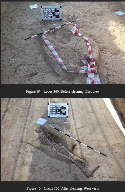 |
||||||||||||||||||||||||||||||||||||||||||||||||||||||||||||||||||||||||||||||||||||||||||||||||||||||||||||||||||||||||||||||||||||||||||||||||||||||||||||||||||||||||||||||||||||||||||||||||||||
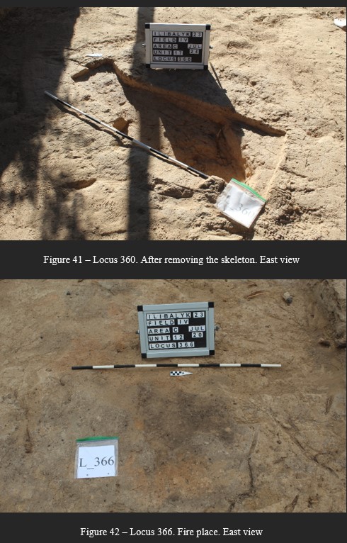 |
||||||||||||||||||||||||||||||||||||||||||||||||||||||||||||||||||||||||||||||||||||||||||||||||||||||||||||||||||||||||||||||||||||||||||||||||||||||||||||||||||||||||||||||||||||||||||||||||||||
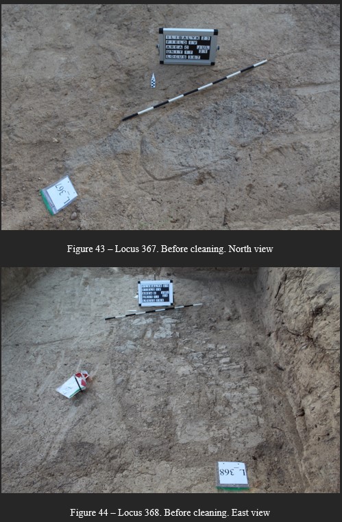 |
||||||||||||||||||||||||||||||||||||||||||||||||||||||||||||||||||||||||||||||||||||||||||||||||||||||||||||||||||||||||||||||||||||||||||||||||||||||||||||||||||||||||||||||||||||||||||||||||||||
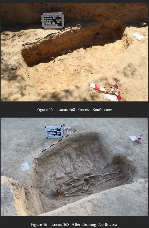 |
||||||||||||||||||||||||||||||||||||||||||||||||||||||||||||||||||||||||||||||||||||||||||||||||||||||||||||||||||||||||||||||||||||||||||||||||||||||||||||||||||||||||||||||||||||||||||||||||||||
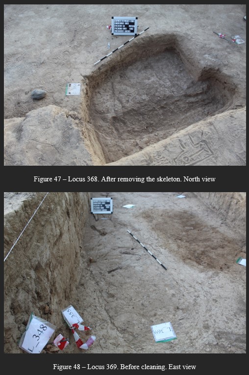 |
||||||||||||||||||||||||||||||||||||||||||||||||||||||||||||||||||||||||||||||||||||||||||||||||||||||||||||||||||||||||||||||||||||||||||||||||||||||||||||||||||||||||||||||||||||||||||||||||||||
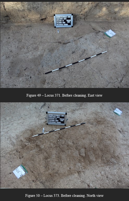 |
||||||||||||||||||||||||||||||||||||||||||||||||||||||||||||||||||||||||||||||||||||||||||||||||||||||||||||||||||||||||||||||||||||||||||||||||||||||||||||||||||||||||||||||||||||||||||||||||||||
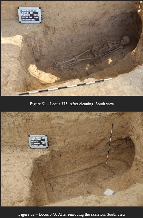 |
||||||||||||||||||||||||||||||||||||||||||||||||||||||||||||||||||||||||||||||||||||||||||||||||||||||||||||||||||||||||||||||||||||||||||||||||||||||||||||||||||||||||||||||||||||||||||||||||||||
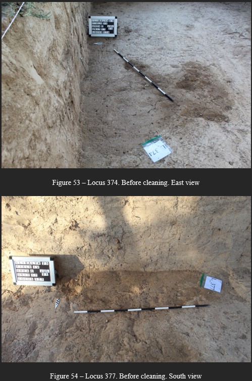 |
||||||||||||||||||||||||||||||||||||||||||||||||||||||||||||||||||||||||||||||||||||||||||||||||||||||||||||||||||||||||||||||||||||||||||||||||||||||||||||||||||||||||||||||||||||||||||||||||||||
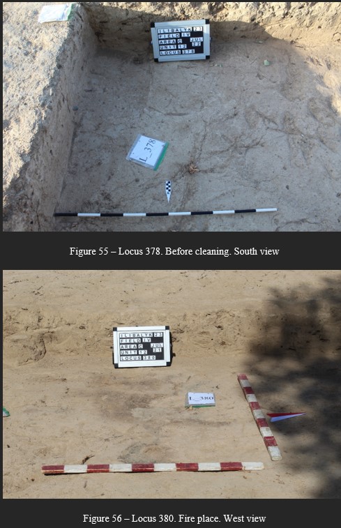 |
||||||||||||||||||||||||||||||||||||||||||||||||||||||||||||||||||||||||||||||||||||||||||||||||||||||||||||||||||||||||||||||||||||||||||||||||||||||||||||||||||||||||||||||||||||||||||||||||||||
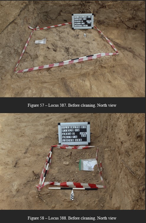 |
||||||||||||||||||||||||||||||||||||||||||||||||||||||||||||||||||||||||||||||||||||||||||||||||||||||||||||||||||||||||||||||||||||||||||||||||||||||||||||||||||||||||||||||||||||||||||||||||||||
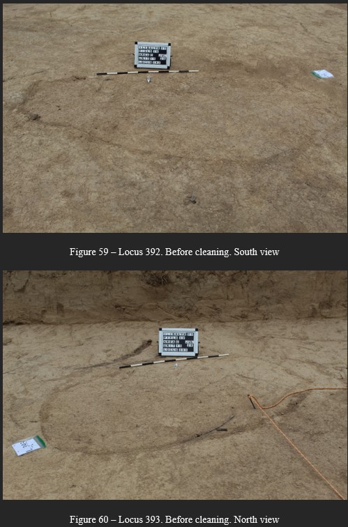 |
||||||||||||||||||||||||||||||||||||||||||||||||||||||||||||||||||||||||||||||||||||||||||||||||||||||||||||||||||||||||||||||||||||||||||||||||||||||||||||||||||||||||||||||||||||||||||||||||||||
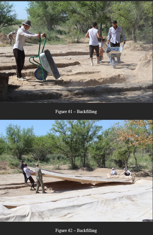 |
||||||||||||||||||||||||||||||||||||||||||||||||||||||||||||||||||||||||||||||||||||||||||||||||||||||||||||||||||||||||||||||||||||||||||||||||||||||||||||||||||||||||||||||||||||||||||||||||||||
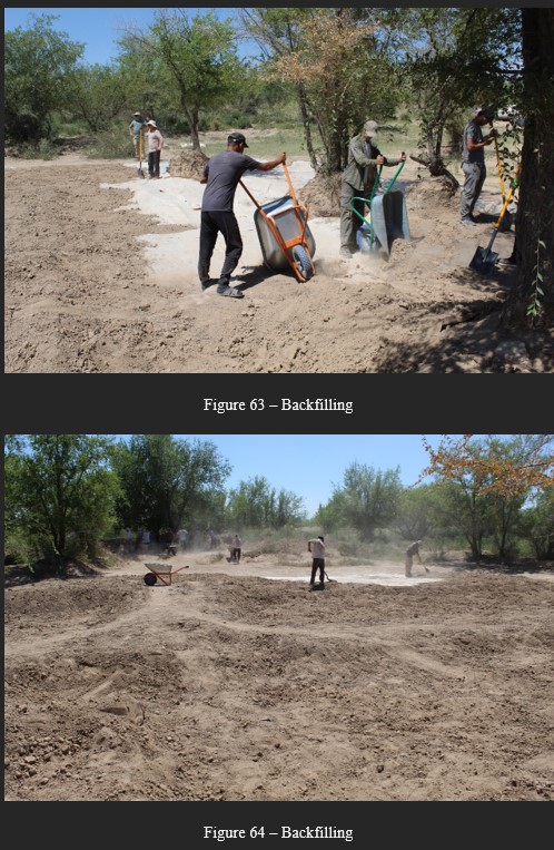 |
||||||||||||||||||||||||||||||||||||||||||||||||||||||||||||||||||||||||||||||||||||||||||||||||||||||||||||||||||||||||||||||||||||||||||||||||||||||||||||||||||||||||||||||||||||||||||||||||||||
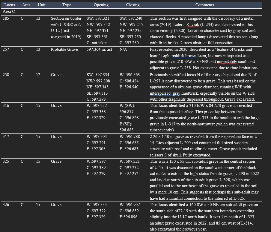
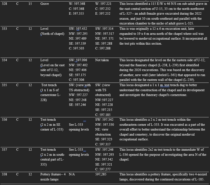
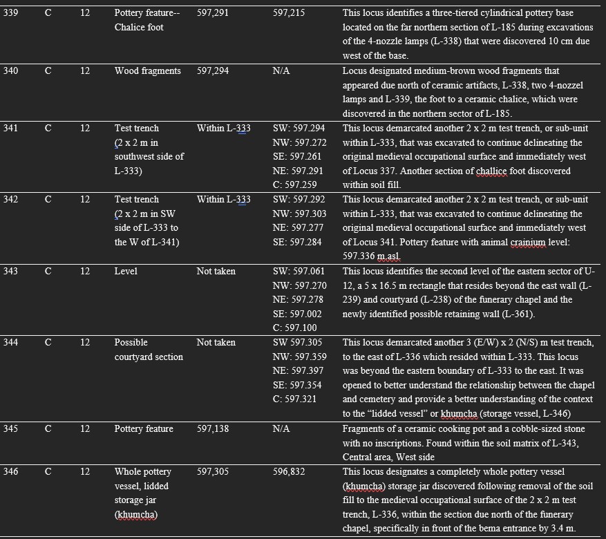
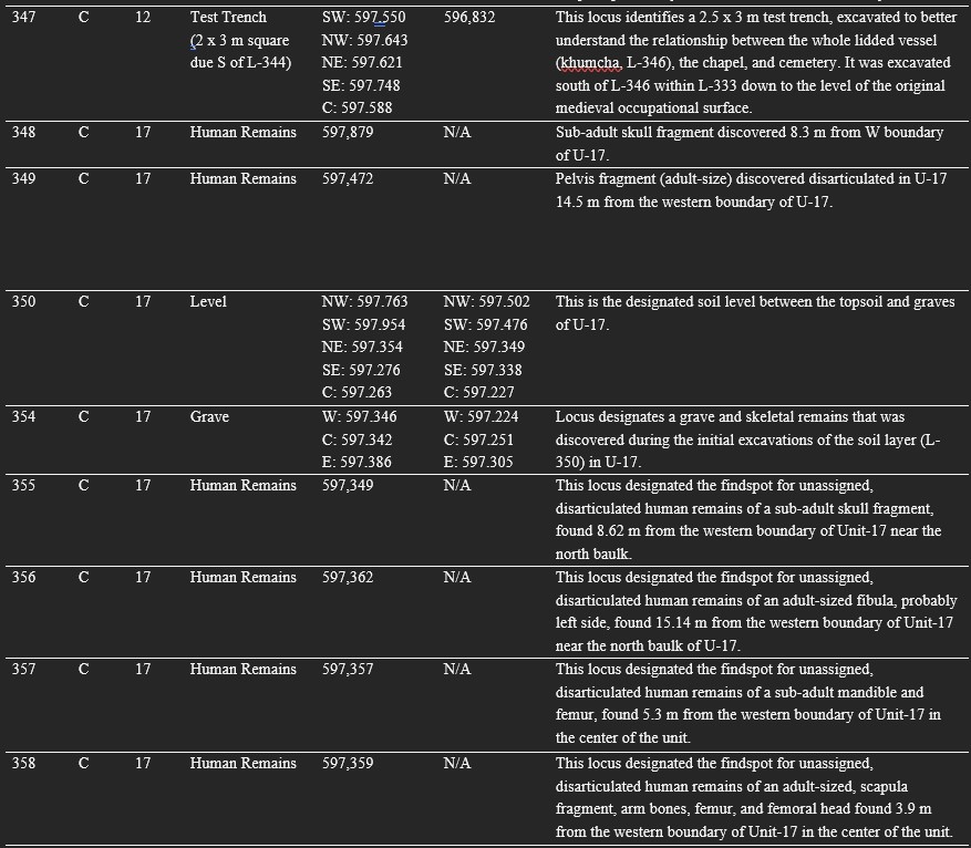
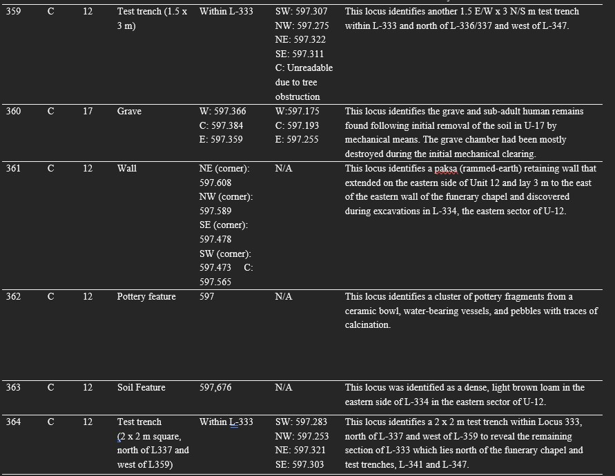
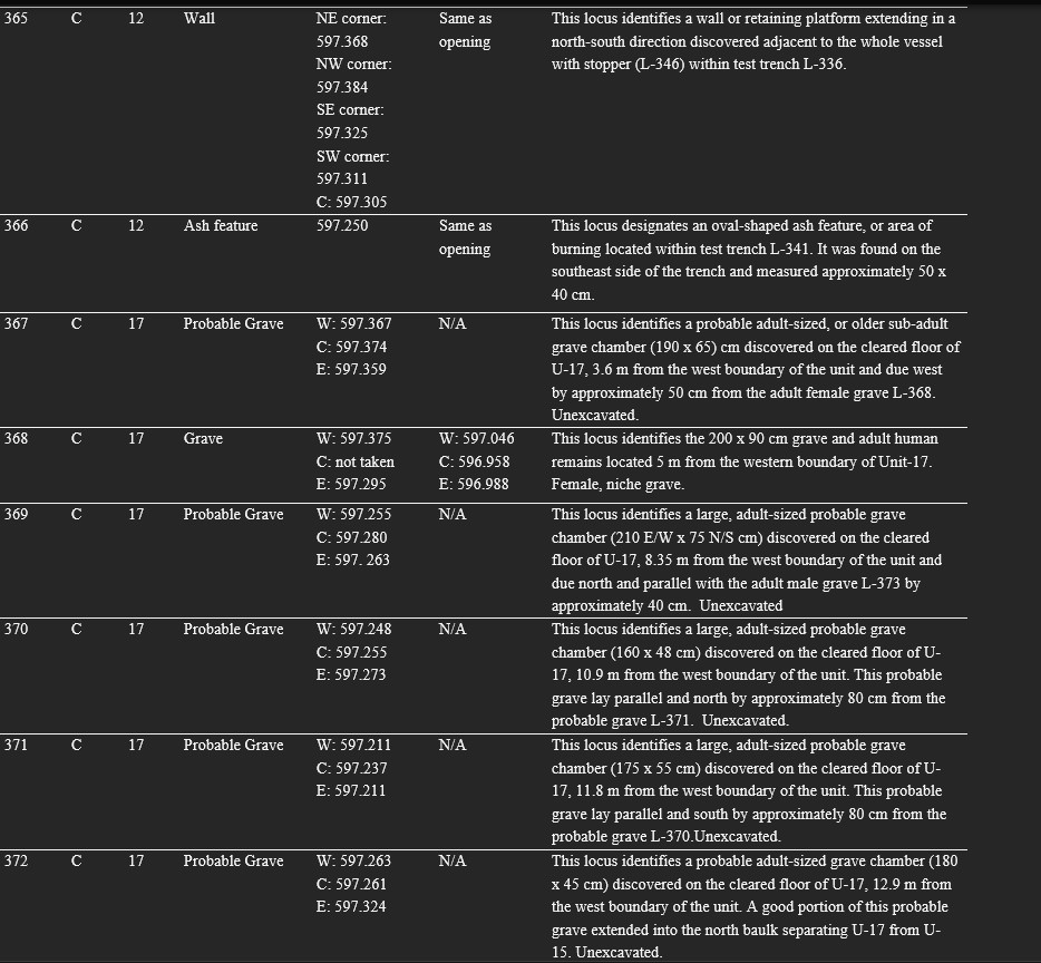
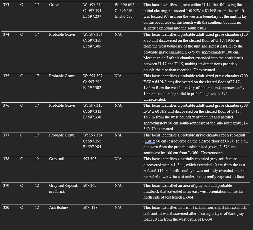
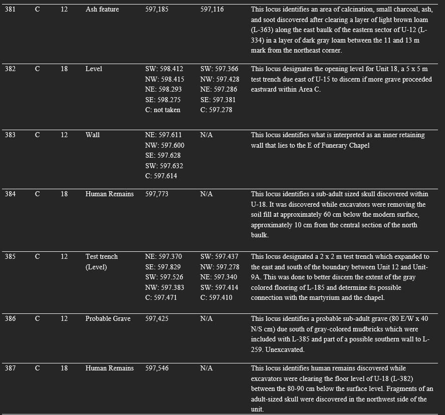
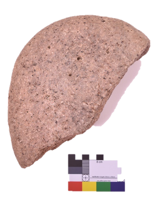
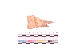
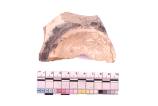
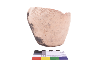
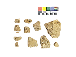
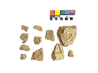
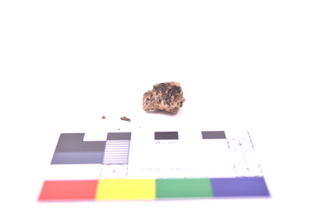
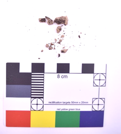
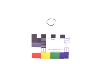
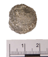
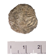
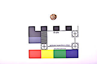
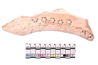
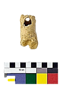
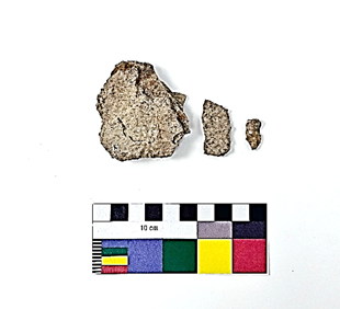
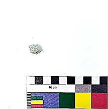
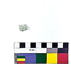
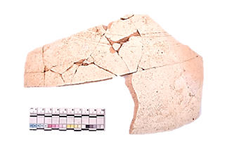
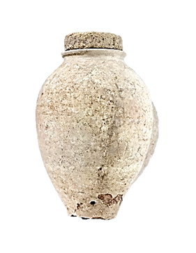
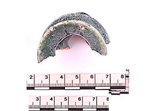
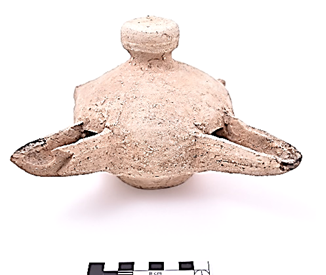
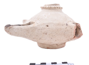
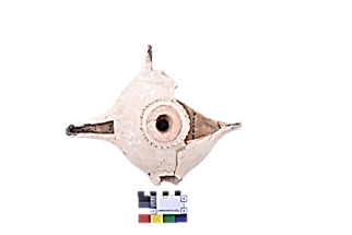
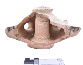
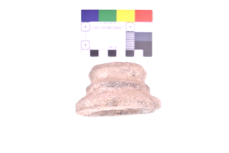
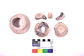
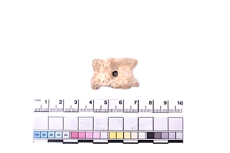
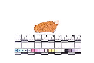
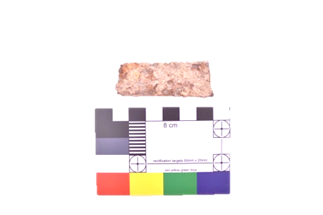
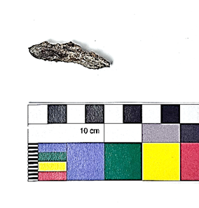
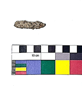
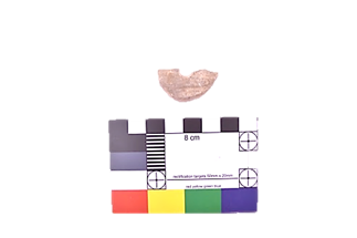
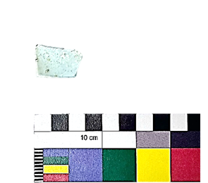
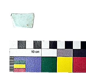
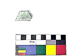
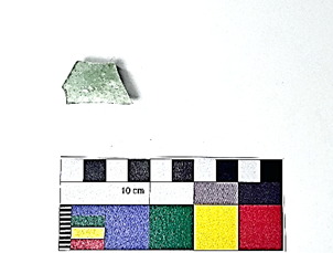
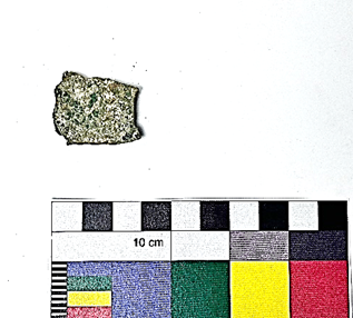
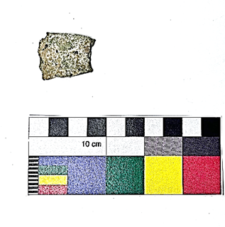
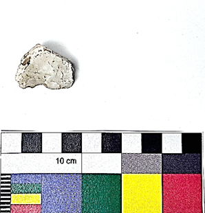
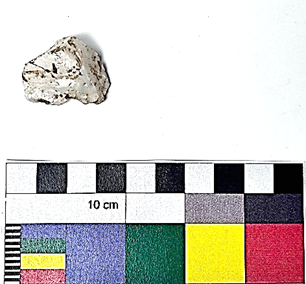
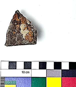
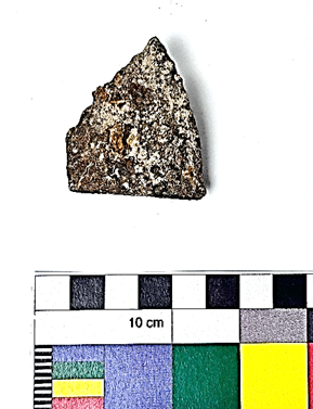
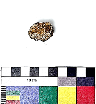
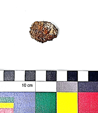
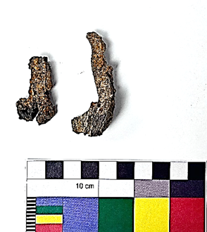
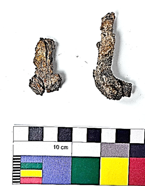
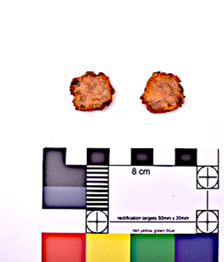
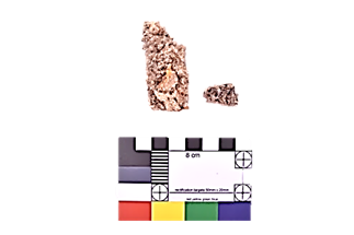
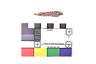
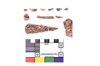
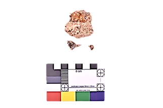
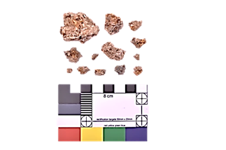
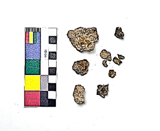
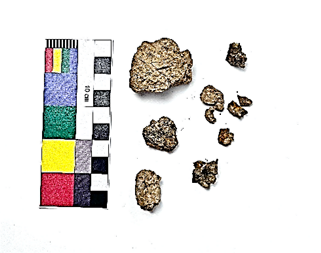
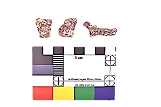
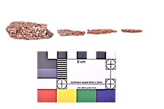
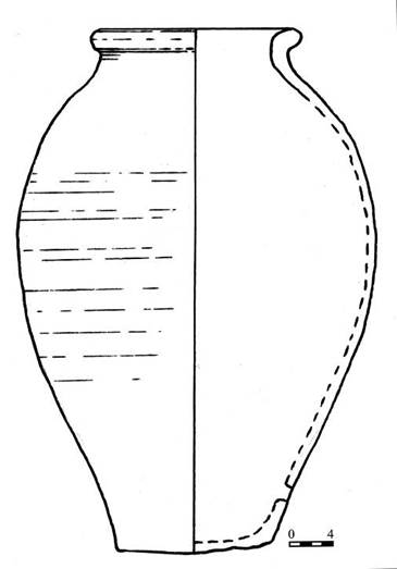
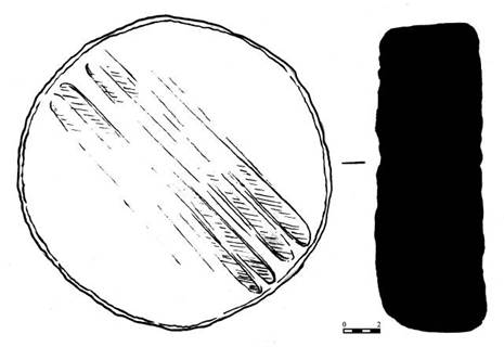
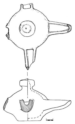
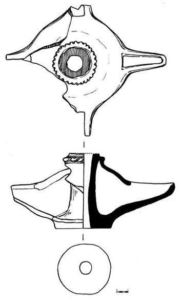
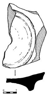
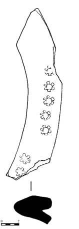
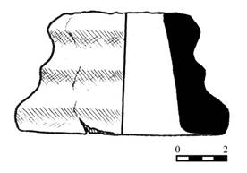
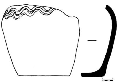
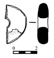
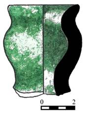
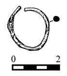
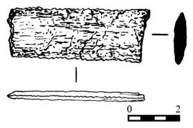
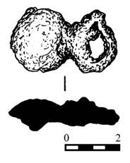
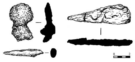
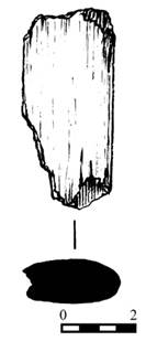
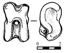
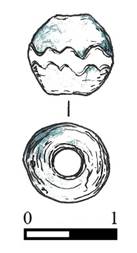
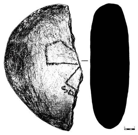

| copyright by The Society for the Exploration
of EurAsia| E-mail
| Home
| ![]()